
| TRI-STATE/MILTON J. FERGUSON HUNTINGTON WV |
| |
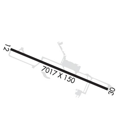
| Lat: N 3822.1 Long: W 08233.6 Elev: 828 Var: +06 Longest Runway: 7017 | ||
| Clr Del: 118.05 Dept. ATIS: 125.2 Arr. ATIS: 125.2 Ground: 121.9 Tower: 118.5 | ||
| ||||||||||||||||||||||||||||||||||||||||||||
| ||||||||||||||||||||||||||||||||||||||||||||
| ||||||||||||||||||||||||||||||||||||||||||||
| Rwy | Rwy | |||||||
| 7017x150 | 7017' | 109.90 - 118° | 7017x150 | 6516' | 108.70 - 298° | |||
| Runway ID | Single Wheel | Double Wheel | Double Tandem Wheel | Dual Double Wheel |
| 12/30 | 110,000 | 140,000 | 230,000 | N/A |
| These numbers are Advisory and are not limits. The Airport Manager should have more accurate Weight Limits | ||||
 Airport Diagram might not be current. | |
| Facility Name: | TRI-STATE/MILTON J FERGUSON FLD |
| City Name: | HUNTINGTON |
| County: | WAYNE |
| State abbrev: | WV |
| State Name: | WEST VIRGINIA |
| Ownership: | PUBLICLY OWNED |
| Use: | OPEN TO THE PUBLIC |
| Owner's Name: | TRI-STATE AIRPORT AUTH. |
| Address: | 1449 AIRPORT ROAD |
| HUNTINGTON, WV 25704 | |
| Owner's Phone: | 304-453-6165 |
| Manager's Name: | BRENT BROWN |
| Address: | 1449 AIRPORT ROAD |
| HUNTINGTON, WV 25704 | |
| Phone: | 304-453-6165 |
| FAA Region: | EASTERN |
| FAA Field Office: | BKW |
| Date | Sunrise | Sunset |
|---|---|---|
| 09/24/21 Friday | 7:19 | 19:24 |
| 09/25/21 Saturday | 7:20 | 19:23 |
| 09/26/21 Sunday | 7:21 | 19:21 |
| 09/27/21 Monday | 7:22 | 19:20 |
| 09/28/21 Tuesday | 7:23 | 19:18 |
| 09/29/21 Wednesday | 7:24 | 19:17 |
| 09/30/21 Thursday | 7:25 | 19:15 |
| 10/01/21 Friday | 7:26 | 19:13 |
| 10/02/21 Saturday | 7:27 | 19:12 |
| 10/03/21 Sunday | 7:28 | 19:10 |
| 10/04/21 Monday | 7:29 | 19:09 |
| 10/05/21 Tuesday | 7:29 | 19:07 |
| 10/06/21 Wednesday | 7:30 | 19:06 |
| 10/07/21 Thursday | 7:31 | 19:04 |
| Airport Attendance Schedule | CONTINUOUS |
| Airport Status | OPERATIONAL (This Status can change at any time - please check NOTAMS) |
| Airport Lighting Schedule | |
| Airport Storage Available | Tie Downs, Hanger |
| Extra Services Available | Cargo Handling, Charter, Flight Instruction, Aircraft Sales |
| Wind Indicator | YES - (lighted) |
| Control Tower | YES |
| CTAF Frequency | |
| Unicom Frequency | 122.950 |
| Rotating Beacon Color | CLEAR-GREEN (Light Land Airport) |
| Segmented Circle | NO |
| Landing Fee | YES; FEE FOR ACFT UNLESS FUEL PURCHASED. |
| Airport Inspected | FEDERAL - performed by FAA AIRPORTS FIELD PERSONNEL |
| Inspection Date | 03/19/2019 |
| Type of Fuel Available | Grade 100LL, JET A (freeze point -40C) |
| Airframe Repair Service | MAJOR |
| Power Plant Repair Service | MAJOR |
| Latitude | N3822.1 |
| Longitude | W08233.6 (ESTIMATED) |
| Arpt Elevation | 828ft (SURVEYED) |
| Magnetic Variation | 06W |
| 3 miles S | of HUNTINGTON |
| Traffic Pattern Altitude | |
| Sectional Chart | CINCINNATI |
| Operations (Reported) | Yearly | Avg. Daily |
|---|---|---|
| General Aviation Transient | 5995 | 16 |
| General Aviation Local | 1500 | 4 |
| Air Taxi | 3912 | 11 |
| Commerical | 2058 | 6 |
| Commuter | 0 | 0 |
| Military | 768 | 2 |
| Aircraft based on Field | |
|---|---|
| General Aviation Singles | 30 |
| General Aviation Multi | 5 |
| Jet Aircraft | 3 |
| General Aviation Helicopters | 1 |
| Military Aircraft | 0 |
| Gliders | 0 |
| Ultralights | 2 |
| FSS on field | NO |
| FSS tie-in | ELKINS |
| FSS Phone | 1-800-WX-BRIEF |
| Who issues Notams | HTS |
| Notam D service at airport | YES |
| ARTCC Name | INDIANAPOLIS |
| Airport Certification | AIRPORT RECEIVING SCHEDULED AIR CARRIER SERVICE FROM CARRIERS CERTIFICATED BY THE CIVIL AERONAUTICS BOARD |
| Aircraft Rescue & Firefighting Index | AIRPORT HAS A CERTIFICATE UNDER CFR PART 139 |
| Airport of Entry | No |
| Custom Landing Rights | YES |
| Joint Civil/Military | No |
| Military Landing rights | YES |
| NATIONAL PLAN OF INTEGRATED AIRPORT SYSTEMS (NPIAS) |
| GRANT AGREEMENTS UNDER FAAP/ADAP/AIP |
| ASSURANCES PURSUANT TO TITLE VI, CIVIL RIGHTS ACT OF 1964 |
| COMPLIANCE WITH ACCESSIBILITY TO THE HANDICAPPED |
| PILOTS REPORT POSSIBILITY OF MISTAKING FUEL BURNING STACK LCTD APRXLY 2 MI W RY 12 FOR APCH LGTG SFL. |
| RY 12 OBSTN TWR LCTD 5100 FT W 600 FT N END RY. |
| BIRDS & DEER ON & INVOF ARPT. |
Airport Communications & Frequencies:
| ||||||||||||||||||||||||||||||
| Runway: 12 | Runway: 30 | ||
| Mag heading: | 118° | Mag heading: | 298° |
| Rwy Slope: | .00% Up | Rwy Slope: | .00% Down |
| Approach: | ILS | Approach: | ILS |
| Pattern: | Left Traffic | Pattern: | Left Traffic |
| Markings: | PRECISION INSTRUMENT | Markings: | PRECISION INSTRUMENT |
| Marking Condition: | GOOD | Marking Condition: | GOOD |
| Arresting Dev: | Arresting Dev: | ||
| Lat & Long: | N3822.3 W08234.3 | Lat. & Long.: | N3821.9 W08232.9 |
| Elev: | 827.9 ft. MSL | Elev: | 828.1 ft. MSL |
| TCH: | 56 ft. AGL | TCH: | 49 ft. AGL |
| Visual Glide Path: | 3.00 degrees | Visual Glide Path: | 3.00 degrees |
| Displaced Threshold: | No | Displaced Threshold: | 501 feet |
| Touchdown Zone: | YES | Touchdown Zone: | YES |
| Touchdown Elev.: | 828.0 feet | Touchdown Elev.: | 828.3 feet |
| Visual Glide Slope: | 4-Light PAPI on LEFT side of Runway | Visual Glide Slope: | 4-Light PAPI on LEFT side of Runway; RY 30 P4L UNUSBL BYD 7 DEGS LEFT OF CNTRLN. |
| RVR Equipment: | TOUCHDOWN | RVR Equipment: | ROLLOUT |
| RVV Equipment: | NO | RVV Equipment: | NO |
| Approach Lights: | MALSR - 1,400 foot medium intensity approach lighting system with runway alignment indicator lights | Approach Lights: | |
| REIL: | NO | REIL: | YES |
| Centerline Lights: | NO | Centerline Lights: | NO |
| Touchdown lights: | NO | Touchdown lights: | NO |
| Runway Category: | Precision Instrument Runway | Runway Category: | Precision Instrument Runway |
| Declared Distances: | TORA:7017' TODA:7017' ASDA:6516' LDA:6516' | Declared Distances: | TORA:7017' TODA:7017' ASDA:7017' LDA:6516' |
| Obstructions: | TREES | Obstructions: | |
| Marked: | NOT Marked/Lighted | Marked: | |
| Clearance slope: | 21:1 | Clearance slope: | 50:1 |
| Obstruction height: | 36 feet AGL | Obstruction height: | |
| Dist. from runway: | 950 feet | Dist. from runway: | |
| Centerline offset: | 400 left of centerline | Centerline offset: | |
| Comments: | Comments: |
Thanks for using FltPlan.com
all rights reserved © 1999-2021 by Flight Plan LLC
