| ROSCOMMON COUNTY - BLODGETT HOUGHTON LAKE MI |
| |
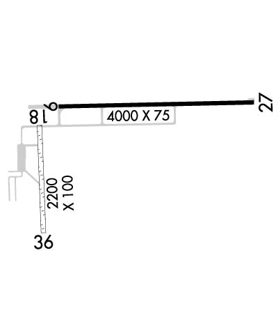
| Lat: N 4421.6 Long: W 08440.2 Elev: 1150 Var: +05 Longest Runway: 4000 | ||
| AWOS: 111.6 CTAF: 122.8 | ||
| |||||||||||||||||||||||
| |||||||||||||||||||||||
| |||||||||||||||||||||||
| Rwy | Rwy | |||||||
| 4000x75 | 4000' | 4000x75 | 4000' | |||||
| 2200x100 | 2200' | 2200x100 | 2000' | |||||
| Runway ID | Single Wheel | Double Wheel | Double Tandem Wheel | Dual Double Wheel |
| 09/27 | 24,000 | N/A | N/A | N/A |
| 18/36 | N/A | N/A | N/A | N/A |
| These numbers are Advisory and are not limits. The Airport Manager should have more accurate Weight Limits | ||||
 Airport Diagram might not be current. | |
| Facility Name: | ROSCOMMON COUNTY - BLODGETT MEML |
| City Name: | HOUGHTON LAKE |
| County: | ROSCOMMON |
| State abbrev: | MI |
| State Name: | MICHIGAN |
| Ownership: | PUBLICLY OWNED |
| Use: | OPEN TO THE PUBLIC |
| Owner's Name: | ROSCOMMON COUNTY |
| Address: | 500 LAKE ST |
| ROSCOMMON, MI 48653-7664 | |
| Owner's Phone: | 989-275-8021 |
| Manager's Name: | ERIC J JAROCH |
| Address: | 5218 E HOUGHTON LAKE DR |
| HOUGHTON LAKE, MI 48629-8313 | |
| Phone: | 989-366-7660 |
| FAA Region: | GREAT LAKES |
| FAA Field Office: | DET |
| Date | Sunrise | Sunset |
|---|---|---|
| 09/24/21 Friday | 7:28 | 19:33 |
| 09/25/21 Saturday | 7:29 | 19:31 |
| 09/26/21 Sunday | 7:30 | 19:29 |
| 09/27/21 Monday | 7:31 | 19:27 |
| 09/28/21 Tuesday | 7:33 | 19:25 |
| 09/29/21 Wednesday | 7:34 | 19:24 |
| 09/30/21 Thursday | 7:35 | 19:22 |
| 10/01/21 Friday | 7:36 | 19:20 |
| 10/02/21 Saturday | 7:37 | 19:18 |
| 10/03/21 Sunday | 7:39 | 19:16 |
| 10/04/21 Monday | 7:40 | 19:14 |
| 10/05/21 Tuesday | 7:41 | 19:13 |
| 10/06/21 Wednesday | 7:42 | 19:11 |
| 10/07/21 Thursday | 7:43 | 19:09 |
| Airport Attendance Schedule | 7 Days A Week 0900-1700; ARPT UNATNDD MAJOR HOLIDAYS. |
| Airport Status | OPERATIONAL (This Status can change at any time - please check NOTAMS) |
| Airport Lighting Schedule | HIRL RY 09/27 PRESET ON LOW INTST DUSK-2100; AFT 2100 ACTVT - CTAF. TO INCR INTST & ACTVT REIL & PAPI RYS 09 & 27 - CTAF. |
| Airport Storage Available | Tie Downs, Hanger |
| Extra Services Available | NONE |
| Wind Indicator | YES - (lighted) |
| Control Tower | NO |
| CTAF Frequency | 122.800 |
| Unicom Frequency | 122.800 |
| Rotating Beacon Color | CLEAR-GREEN (Light Land Airport) |
| Segmented Circle | YES |
| Landing Fee | NO |
| Airport Inspected | STATE - performed by STATE AERONAUTICAL PERSONNEL |
| Inspection Date | 06/26/2019 |
| Type of Fuel Available | Grade 100LL |
| Airframe Repair Service | MAJOR |
| Power Plant Repair Service | MAJOR |
| Latitude | N4421.6 |
| Longitude | W08440.2 (ESTIMATED) |
| Arpt Elevation | 1149ft (SURVEYED) |
| Magnetic Variation | 05W |
| 5 miles NE | of HOUGHTON LAKE |
| Traffic Pattern Altitude | |
| Sectional Chart | LAKE HURON |
| Operations (Reported) | Yearly | Avg. Daily |
|---|---|---|
| General Aviation Transient | 6450 | 18 |
| General Aviation Local | 6450 | 18 |
| Air Taxi | 0 | 0 |
| Commerical | 0 | 0 |
| Commuter | 0 | 0 |
| Military | 0 | 0 |
| Aircraft based on Field | |
|---|---|
| General Aviation Singles | 17 |
| General Aviation Multi | 0 |
| Jet Aircraft | 0 |
| General Aviation Helicopters | 0 |
| Military Aircraft | 0 |
| Gliders | 0 |
| Ultralights | 0 |
| FSS on field | NO |
| FSS tie-in | LANSING |
| FSS Phone | 1-800-WX-BRIEF |
| Who issues Notams | HTL |
| Notam D service at airport | YES |
| ARTCC Name | MINNEAPOLIS |
| Airport Certification | |
| Aircraft Rescue & Firefighting Index | None |
| Airport of Entry | No |
| Custom Landing Rights | No |
| Joint Civil/Military | No |
| Military Landing rights | YES |
| NATIONAL PLAN OF INTEGRATED AIRPORT SYSTEMS (NPIAS) |
| GRANT AGREEMENTS UNDER FAAP/ADAP/AIP |
| ASSURANCES PURSUANT TO TITLE VI, CIVIL RIGHTS ACT OF 1964 |
| ANIMALS ON & INVOF ARPT. |
| 2203 FT MSL (883 AGL) TOWER 4.2 NM SW OF ARPT. |
| RY 18/36 CLSD WHEN SNOW COVERED XCPT FOR SKI-EQUIPPED ACFT. |
| FOR CD CTC MINNEAPOLIS ARTCC AT 651-463-5588. |
Airport Communications & Frequencies:
| |||||||||
| Runway: 09 | Runway: 27 | ||
| Mag heading: | 94° | Mag heading: | 274° |
| Rwy Slope: | -.08% Down | Rwy Slope: | .08% Up |
| Approach: | Approach: | ||
| Pattern: | Left Traffic | Pattern: | Left Traffic |
| Markings: | NONPRECISION INSTRUMENT | Markings: | NONPRECISION INSTRUMENT |
| Marking Condition: | GOOD | Marking Condition: | GOOD |
| Arresting Dev: | Arresting Dev: | ||
| Lat & Long: | N4421.7 W08440.4 | Lat. & Long.: | N4421.7 W08439.5 |
| Elev: | 1147.8 ft. MSL | Elev: | 1144.7 ft. MSL |
| TCH: | 32 ft. AGL | TCH: | 32 ft. AGL |
| Visual Glide Path: | 3.50 degrees | Visual Glide Path: | 3.50 degrees |
| Displaced Threshold: | No | Displaced Threshold: | No |
| Touchdown Zone: | YES | Touchdown Zone: | YES |
| Touchdown Elev.: | 1147.8 feet | Touchdown Elev.: | 1145.5 feet |
| Visual Glide Slope: | 4-Light PAPI on LEFT side of Runway | Visual Glide Slope: | 4-Light PAPI on RIGHT side of Runway |
| RVR Equipment: | RVR Equipment: | ||
| RVV Equipment: | NO | RVV Equipment: | NO |
| Approach Lights: | Approach Lights: | ||
| REIL: | YES | REIL: | YES |
| Centerline Lights: | NO | Centerline Lights: | NO |
| Touchdown lights: | NO | Touchdown lights: | NO |
| Runway Category: | Runway with a Non-precision Approach | Runway Category: | Runway with a Non-precision Approach |
| Declared Distances: | Declared Distances: | ||
| Obstructions: | TREES | Obstructions: | |
| Marked: | NOT Marked/Lighted | Marked: | |
| Clearance slope: | 34:1 | Clearance slope: | 50:1 |
| Obstruction height: | 57 feet AGL | Obstruction height: | |
| Dist. from runway: | 2171 feet | Dist. from runway: | |
| Centerline offset: | B | Centerline offset: | |
| Comments: | Comments: |
| Runway: 18 | Runway: 36 | ||
| Mag heading: | 183° | Mag heading: | 3° |
| Rwy Slope: | -.18% Down | Rwy Slope: | .18% Up |
| Approach: | Approach: | ||
| Pattern: | Left Traffic | Pattern: | Left Traffic |
| Markings: | Markings: | ||
| Marking Condition: | 18/36 MKD WITH 3 FT YELLOW CONES. | Marking Condition: | |
| Arresting Dev: | Arresting Dev: | ||
| Lat & Long: | N4421.6 W08440.5 | Lat. & Long.: | N4421.3 W08440.5 |
| Elev: | 1148.3 ft. MSL | Elev: | 1144.3 ft. MSL |
| TCH: | TCH: | ||
| Visual Glide Path: | Visual Glide Path: | ||
| Displaced Threshold: | No | Displaced Threshold: | 200 feet |
| Touchdown Zone: | YES | Touchdown Zone: | YES |
| Touchdown Elev.: | 1149.7 feet | Touchdown Elev.: | 1149.7 feet |
| Visual Glide Slope: | Visual Glide Slope: | ||
| RVR Equipment: | RVR Equipment: | ||
| RVV Equipment: | NO | RVV Equipment: | NO |
| Approach Lights: | Approach Lights: | ||
| REIL: | NO | REIL: | NO |
| Centerline Lights: | NO | Centerline Lights: | NO |
| Touchdown lights: | NO | Touchdown lights: | NO |
| Runway Category: | Runway with a Visual Approach | Runway Category: | Runway with a Visual Approach |
| Declared Distances: | Declared Distances: | ||
| Obstructions: | TREES | Obstructions: | TREES |
| Marked: | NOT Marked/Lighted | Marked: | NOT Marked/Lighted |
| Clearance slope: | 21:1 | Clearance slope: | 16:1; RY 36 APCH RATIO 18:1 TO DSPLCD THLD. |
| Obstruction height: | 65 feet AGL | Obstruction height: | 93 feet AGL |
| Dist. from runway: | 1365 feet | Dist. from runway: | 1500 feet |
| Centerline offset: | Centerline offset: | ||
| Comments: | Comments: |
Thanks for using FltPlan.com
all rights reserved © 1999-2021 by Flight Plan LLC