
| HUNTSVILLE INTL-CARL T JONES F HUNTSVILLE AL |
| |
| Lat: N 3438.2 Long: W 08646.5 Elev: 629 Var: +04 Longest Runway: 12600 | ||
| Clr Del: 120.35 Dept. ATIS: 121.25 Arr. ATIS: 121.25 AWOS: 121.25 Ground: 121.9 Tower: 127.6 | ||
| |||||||||||||||||||||||||||||||||||||||||||||||||||||||||||||||||||||
| |||||||||||||||||||||||||||||||||||||||||||||||||||||||||||||||||||||
| |||||||||||||||||||||||||||||||||||||||||||||||||||||||||||||||||||||
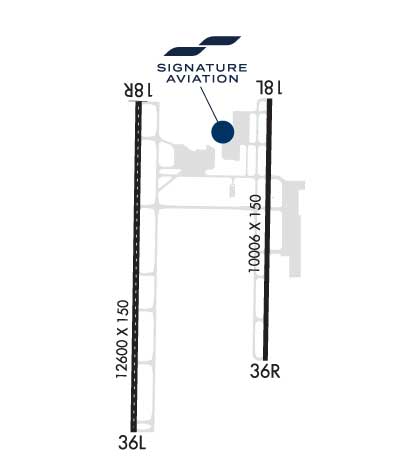
| FBOs at nearby airports who want your business: | |||||||||||||||||
| |||||||||||||||||
| |||||||||||||||||
| Rwy | Rwy | |||||||
| 10001x150 | 10001' | 111.90 - 184° | 10001x150 | 9801' | 109.55 - 004° | |||
| 12600x150 | 12600' | 109.30 - 184° | 12600x150 | 12600' | 108.50 - 004° | |||
| Runway ID | Single Wheel | Double Wheel | Double Tandem Wheel | Dual Double Wheel |
| 18L/36R | 120,000 | 250,000 | 550,000 | N/A |
| 18R/36L | 120,000 | 250,000 | 550,000 | N/A |
| These numbers are Advisory and are not limits. The Airport Manager should have more accurate Weight Limits | ||||
 Airport Diagram might not be current. | |
| Facility Name: | HUNTSVILLE INTL-CARL T JONES FLD |
| City Name: | HUNTSVILLE |
| County: | MADISON |
| State abbrev: | AL |
| State Name: | ALABAMA |
| Ownership: | PUBLICLY OWNED |
| Use: | OPEN TO THE PUBLIC |
| Owner's Name: | HUNTSVILLE MADISON COUNTY; AIRPORT AUTHORITY |
| Address: | 1000 GLENN HEARN BLVD, |
| HUNTSVILLE, AL 35824 | |
| Owner's Phone: | 256-772-9395 |
| Manager's Name: | RICHARD TUCKER |
| Address: | 1000 GLENN HEARN BLVD,, BOX 20008 |
| HUNTSVILLE, AL 35824 | |
| Phone: | 256-258-1955 |
| FAA Region: | SOUTHERN |
| FAA Field Office: | JAN |
| Date | Sunrise | Sunset |
|---|---|---|
| 09/24/21 Friday | 6:36 | 18:41 |
| 09/25/21 Saturday | 6:37 | 18:40 |
| 09/26/21 Sunday | 6:38 | 18:39 |
| 09/27/21 Monday | 6:39 | 18:37 |
| 09/28/21 Tuesday | 6:39 | 18:36 |
| 09/29/21 Wednesday | 6:40 | 18:34 |
| 09/30/21 Thursday | 6:41 | 18:33 |
| 10/01/21 Friday | 6:42 | 18:31 |
| 10/02/21 Saturday | 6:42 | 18:30 |
| 10/03/21 Sunday | 6:43 | 18:29 |
| 10/04/21 Monday | 6:44 | 18:27 |
| 10/05/21 Tuesday | 6:45 | 18:26 |
| 10/06/21 Wednesday | 6:45 | 18:25 |
| 10/07/21 Thursday | 6:46 | 18:23 |
| Airport Attendance Schedule | CONTINUOUS |
| Airport Status | OPERATIONAL (This Status can change at any time - please check NOTAMS) |
| Airport Lighting Schedule | ACTVT MALSR RWY 18L, 36L & 36R; HIRL RWY 18L/36R & 18R/36L - CTAF. RWY 18R ALSF ON STEP 2 WHEN ATCT CLSD. |
| Airport Storage Available | Tie Downs, Hanger |
| Extra Services Available | Air Freight, Avionics, Cargo Handling, Charter, Flight Instruction, Aircraft Rental, Annual Surveying |
| Wind Indicator | YES - (lighted) |
| Control Tower | YES |
| CTAF Frequency | 127.600 |
| Unicom Frequency | 122.950 |
| Rotating Beacon Color | CLEAR-GREEN (Light Land Airport) |
| Segmented Circle | YES |
| Landing Fee | NO |
| Airport Inspected | FEDERAL - performed by FAA AIRPORTS FIELD PERSONNEL |
| Inspection Date | 07/21/2021 |
| Type of Fuel Available | Grade 100LL, JET A (freeze point -40C) |
| Airframe Repair Service | MAJOR |
| Power Plant Repair Service | MAJOR |
| Latitude | N3438.2 |
| Longitude | W08646.5 (ESTIMATED) |
| Arpt Elevation | 628ft (SURVEYED) |
| Magnetic Variation | 04W |
| 9 miles SW | of HUNTSVILLE |
| Traffic Pattern Altitude | |
| Sectional Chart | ATLANTA |
| Operations (Reported) | Yearly | Avg. Daily |
|---|---|---|
| General Aviation Transient | 17217 | 47 |
| General Aviation Local | 2908 | 8 |
| Air Taxi | 5768 | 16 |
| Commerical | 10558 | 29 |
| Commuter | 0 | 0 |
| Military | 18447 | 51 |
| Aircraft based on Field | |
|---|---|
| General Aviation Singles | 64 |
| General Aviation Multi | 15 |
| Jet Aircraft | 6 |
| General Aviation Helicopters | 0 |
| Military Aircraft | 0 |
| Gliders | 0 |
| Ultralights | 1 |
| FSS on field | NO |
| FSS tie-in | ANNISTON |
| FSS Phone | 1-800-WX-BRIEF |
| Who issues Notams | HSV |
| Notam D service at airport | YES |
| ARTCC Name | MEMPHIS |
| Airport Certification | AIRPORT RECEIVING SCHEDULED AIR CARRIER SERVICE FROM CARRIERS CERTIFICATED BY THE CIVIL AERONAUTICS BOARD |
| Aircraft Rescue & Firefighting Index | AIRPORT HAS A CERTIFICATE UNDER CFR PART 139 |
| Airport of Entry | YES |
| Custom Landing Rights | YES |
| Joint Civil/Military | No |
| Military Landing rights | YES |
| NATIONAL PLAN OF INTEGRATED AIRPORT SYSTEMS (NPIAS) |
| GRANT AGREEMENTS UNDER FAAP/ADAP/AIP |
| ASSURANCES PURSUANT TO TITLE VI, CIVIL RIGHTS ACT OF 1964 |
| LINE UP AND WAIT NA. |
| FOR CD WHEN TWR CLSD, IF UNA TO CTC ON FSS FREQ, CTC MEMPHIS ARTCC AT 901-368-8453/8449. |
| FLT NOTIFICATION SVC (ADCUS) AVBL. |
| INTXN OF TWY J AND SERVICE RD IS UNCONTROLLED. |
Airport Communications & Frequencies:
| |||||||||||||||||||||||||||||||||||||||||||||||||||
| Runway: 18L | Runway: 36R | ||
| Mag heading: | 185° | Mag heading: | 5° |
| Rwy Slope: | -.21% Down | Rwy Slope: | .21% Up |
| Approach: | ILS | Approach: | ILS/DME |
| Pattern: | Left Traffic | Pattern: | Right Traffic |
| Markings: | PRECISION INSTRUMENT | Markings: | PRECISION INSTRUMENT |
| Marking Condition: | GOOD | Marking Condition: | GOOD |
| Arresting Dev: | Arresting Dev: | ||
| Lat & Long: | N3439.2 W08645.9 | Lat. & Long.: | N3437.5 W08646.0 |
| Elev: | 609.3 ft. MSL | Elev: | 588.6 ft. MSL |
| TCH: | 73 ft. AGL | TCH: | 72 ft. AGL |
| Visual Glide Path: | 3.00 degrees | Visual Glide Path: | 3.00 degrees |
| Displaced Threshold: | No | Displaced Threshold: | 200 feet |
| Touchdown Zone: | YES | Touchdown Zone: | YES |
| Touchdown Elev.: | 609.3 feet | Touchdown Elev.: | 594.9 feet |
| Visual Glide Slope: | 4-Light PAPI on RIGHT side of Runway | Visual Glide Slope: | 4-Light PAPI on RIGHT side of Runway |
| RVR Equipment: | TOUCHDOWN-ROLLOUT | RVR Equipment: | TOUCHDOWN-ROLLOUT |
| RVV Equipment: | NO | RVV Equipment: | NO |
| Approach Lights: | MALSR - 1,400 foot medium intensity approach lighting system with runway alignment indicator lights | Approach Lights: | MALSR - 1,400 foot medium intensity approach lighting system with runway alignment indicator lights |
| REIL: | NO | REIL: | NO |
| Centerline Lights: | NO | Centerline Lights: | NO |
| Touchdown lights: | NO | Touchdown lights: | NO |
| Runway Category: | Precision Instrument Runway | Runway Category: | Precision Instrument Runway |
| Declared Distances: | TORA:10001' TODA:10001' ASDA:9801' LDA:9801' | Declared Distances: | TORA:10001' TODA:10001' ASDA:10001' LDA:9801' |
| Runway: 18R | Runway: 36L | ||
| Mag heading: | 185° | Mag heading: | 5° |
| Rwy Slope: | -.14% Down | Rwy Slope: | .14% Up |
| Approach: | ILS | Approach: | ILS |
| Pattern: | Right Traffic | Pattern: | Left Traffic |
| Markings: | PRECISION INSTRUMENT | Markings: | PRECISION INSTRUMENT |
| Marking Condition: | GOOD | Marking Condition: | GOOD |
| Arresting Dev: | Arresting Dev: | ||
| Lat & Long: | N3439.2 W08646.9 | Lat. & Long.: | N3437.1 W08647.0 |
| Elev: | 628.4 ft. MSL | Elev: | 611.2 ft. MSL |
| TCH: | TCH: | ||
| Visual Glide Path: | Visual Glide Path: | ||
| Displaced Threshold: | No | Displaced Threshold: | No |
| Touchdown Zone: | YES | Touchdown Zone: | YES |
| Touchdown Elev.: | 628.9 feet | Touchdown Elev.: | 615.5 feet |
| Visual Glide Slope: | Visual Glide Slope: | ||
| RVR Equipment: | TOUCHDOWN-MIDFIELD-ROLLOUT | RVR Equipment: | TOUCHDOWN-MIDFIELD-ROLLOUT |
| RVV Equipment: | NO | RVV Equipment: | NO |
| Approach Lights: | ALSF2 - standard 2,400 foot high intensity approach lighting system with sequenced flashers, Category II or III | Approach Lights: | MALSR - 1,400 foot medium intensity approach lighting system with runway alignment indicator lights |
| REIL: | NO | REIL: | NO |
| Centerline Lights: | YES | Centerline Lights: | YES |
| Touchdown lights: | YES | Touchdown lights: | YES |
| Runway Category: | Precision Instrument Runway | Runway Category: | Precision Instrument Runway |
| Declared Distances: | TORA:12600' TODA:12600' ASDA:12600' LDA:12600' | Declared Distances: | TORA:12600' TODA:12600' ASDA:12600' LDA:12600' |
Thanks for using FltPlan.com
all rights reserved © 1999-2021 by Flight Plan LLC