
| BOONE COUNTY HARRISON AR |
| |
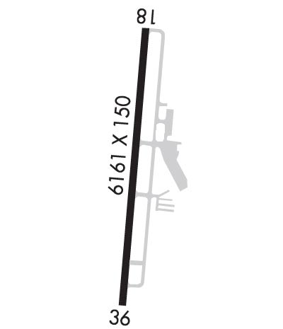
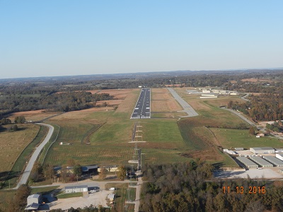
| Lat: N 3615.7 Long: W 09309.3 Elev: 1365 Var: -04 Longest Runway: 6161 | ||
| AWOS: 121.12 CTAF: 123.0 | ||
| ||||||
| ||||||
|
| Rwy | Rwy | |||||||
| 6161x150 | 6161' | 6161x150 | 6161' | 111.70 - 358° | ||||
| Runway ID | Single Wheel | Double Wheel | Double Tandem Wheel | Dual Double Wheel |
| 18/36 | 38,000 | 53,000 | 84,000 | N/A |
| These numbers are Advisory and are not limits. The Airport Manager should have more accurate Weight Limits | ||||
 Airport Diagram might not be current. | |
| Facility Name: | BOONE COUNTY |
| City Name: | HARRISON |
| County: | BOONE |
| State abbrev: | AR |
| State Name: | ARKANSAS |
| Ownership: | PUBLICLY OWNED |
| Use: | OPEN TO THE PUBLIC |
| Owner's Name: | BOONE COUNTY |
| Address: | 100 N MAIN SUITE 300 |
| HARRISON, AR 72601 | |
| Owner's Phone: | 870-741-5760 |
| Manager's Name: | JUDY MC CUTCHEON |
| Address: | PO BOX 1114 |
| HARRISON, AR 72601 | |
| Phone: | 870-741-6954 |
| FAA Region: | SOUTHWEST |
| FAA Field Office: | AOK |
| Date | Sunrise | Sunset |
|---|---|---|
| 09/24/21 Friday | 7:02 | 19:07 |
| 09/25/21 Saturday | 7:03 | 19:05 |
| 09/26/21 Sunday | 7:03 | 19:04 |
| 09/27/21 Monday | 7:04 | 19:02 |
| 09/28/21 Tuesday | 7:05 | 19:01 |
| 09/29/21 Wednesday | 7:06 | 18:59 |
| 09/30/21 Thursday | 7:07 | 18:58 |
| 10/01/21 Friday | 7:08 | 18:56 |
| 10/02/21 Saturday | 7:08 | 18:55 |
| 10/03/21 Sunday | 7:09 | 18:54 |
| 10/04/21 Monday | 7:10 | 18:52 |
| 10/05/21 Tuesday | 7:11 | 18:51 |
| 10/06/21 Wednesday | 7:12 | 18:49 |
| 10/07/21 Thursday | 7:13 | 18:48 |
| Airport Attendance Schedule | 7 Days A Week 0700-1900; FOR SVC AFT HRS CALL 870-741-4510; FEE CHRGD; CALL AHD IF POSS. |
| Airport Status | OPERATIONAL (This Status can change at any time - please check NOTAMS) |
| Airport Lighting Schedule | ACTVT MALSR RWY 36, REIL RWY 18 & HIRL RWY 18/36 - CTAF. |
| Airport Storage Available | Tie Downs, Hanger |
| Extra Services Available | Air Freight, Air Ambulance, Charter, Flight Instruction |
| Wind Indicator | YES - (lighted) |
| Control Tower | NO |
| CTAF Frequency | 123.000 |
| Unicom Frequency | 123.000 |
| Rotating Beacon Color | CLEAR-GREEN (Light Land Airport) |
| Segmented Circle | YES |
| Landing Fee | NO |
| Airport Inspected | STATE - performed by STATE AERONAUTICAL PERSONNEL |
| Inspection Date | 10/25/2018 |
| Type of Fuel Available | Grade 100LL, JET A (freeze point -40C); -10100LL AVBL 24 HRS SELF SERVE. |
| Airframe Repair Service | MINOR |
| Power Plant Repair Service | MINOR |
| Latitude | N3615.7 |
| Longitude | W09309.3 (ESTIMATED) |
| Arpt Elevation | 1364ft (SURVEYED) |
| Magnetic Variation | 04E |
| 3 miles NW | of HARRISON |
| Traffic Pattern Altitude | 836 |
| Sectional Chart | KANSAS CITY |
| Operations (Reported) | Yearly | Avg. Daily |
|---|---|---|
| General Aviation Transient | 4000 | 11 |
| General Aviation Local | 3400 | 9 |
| Air Taxi | 1150 | 3 |
| Commerical | 2100 | 6 |
| Commuter | 0 | 0 |
| Military | 100 | 0 |
| Aircraft based on Field | |
|---|---|
| General Aviation Singles | 37 |
| General Aviation Multi | 8 |
| Jet Aircraft | 2 |
| General Aviation Helicopters | 1 |
| Military Aircraft | 0 |
| Gliders | 0 |
| Ultralights | 0 |
| FSS on field | NO |
| FSS tie-in | JONESBORO |
| FSS Phone | 1-800-WX-BRIEF |
| Who issues Notams | HRO |
| Notam D service at airport | YES |
| ARTCC Name | MEMPHIS |
| Airport Certification | |
| Aircraft Rescue & Firefighting Index | None |
| Airport of Entry | No |
| Custom Landing Rights | No |
| Joint Civil/Military | No |
| Military Landing rights | YES |
| NATIONAL PLAN OF INTEGRATED AIRPORT SYSTEMS (NPIAS) |
| GRANT AGREEMENTS UNDER FAAP/ADAP/AIP |
| OBLIGATIONS ASSUMED BY TRANSFER |
| ASSURANCES PURSUANT TO TITLE VI, CIVIL RIGHTS ACT OF 1964 |
| THIS AIRPORT HAS BEEN SURVEYED BY THE NATIONAL GEODETIC SURVEY. |
| DEER & BIRDS ON & INVOF ARPT. |
| FOR CD CTC MEMPHIS ARTCC AT 901-368-8453/8449. |
Airport Communications & Frequencies:
| |||||||||
| Runway: 18 | Runway: 36 | ||
| Mag heading: | 182° | Mag heading: | 2° |
| Rwy Slope: | -.19% Down | Rwy Slope: | .19% Up |
| Approach: | Approach: | ILS/DME | |
| Pattern: | Left Traffic | Pattern: | Left Traffic |
| Markings: | PRECISION INSTRUMENT | Markings: | PRECISION INSTRUMENT |
| Marking Condition: | GOOD | Marking Condition: | GOOD |
| Arresting Dev: | Arresting Dev: | ||
| Lat & Long: | N3616.2 W09309.2 | Lat. & Long.: | N3615.2 W09309.3 |
| Elev: | 1362.9 ft. MSL | Elev: | 1351.3 ft. MSL |
| TCH: | 50 ft. AGL | TCH: | 50 ft. AGL |
| Visual Glide Path: | 3.00 degrees | Visual Glide Path: | 3.00 degrees |
| Displaced Threshold: | No | Displaced Threshold: | No |
| Touchdown Zone: | YES | Touchdown Zone: | YES |
| Touchdown Elev.: | 1364.5 feet | Touchdown Elev.: | 1351.3 feet |
| Visual Glide Slope: | 4-BOX VASI ON LEFT SIDE OF RUNWAY | Visual Glide Slope: | 4-BOX VASI ON LEFT SIDE OF RUNWAY |
| RVR Equipment: | RVR Equipment: | ||
| RVV Equipment: | NO | RVV Equipment: | NO |
| Approach Lights: | Approach Lights: | MALSR - 1,400 foot medium intensity approach lighting system with runway alignment indicator lights | |
| REIL: | YES | REIL: | NO |
| Centerline Lights: | NO | Centerline Lights: | NO |
| Touchdown lights: | NO | Touchdown lights: | NO |
| Runway Category: | Runway with a Non-precision Approach having visibility minimums greater than 3/4 mile | Runway Category: | Precision Instrument Runway |
| Declared Distances: | Declared Distances: |
Thanks for using FltPlan.com
all rights reserved © 1999-2021 by Flight Plan LLC