| THOMSON-MCDUFFIE COUNTY THOMSON GA |
| |
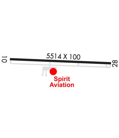
| Lat: N 3331.8 Long: W 08231.0 Elev: 501 Var: +04 Longest Runway: 5514 | ||
| AWOS: 120.62 CTAF: 122.8 | ||
| ||||||||||||||||||||||||||||||||||||||||||||||||||||||||||||||||||||
| ||||||||||||||||||||||||||||||||||||||||||||||||||||||||||||||||||||
| ||||||||||||||||||||||||||||||||||||||||||||||||||||||||||||||||||||
| Rwy | Rwy | |||||||
| 5514x100 | 5215' | 110.75 - 096° | 5514x100 | 5320' | ||||
| Runway ID | Single Wheel | Double Wheel | Double Tandem Wheel | Dual Double Wheel |
| 10/28 | 30,000 | 50,000 | 87,000 | N/A |
| These numbers are Advisory and are not limits. The Airport Manager should have more accurate Weight Limits | ||||
 Airport Diagram might not be current. | |
| Facility Name: | THOMSON/MCDUFFIE COUNTY |
| City Name: | THOMSON |
| County: | MC DUFFIE |
| State abbrev: | GA |
| State Name: | GEORGIA |
| Ownership: | PUBLICLY OWNED |
| Use: | OPEN TO THE PUBLIC |
| Owner's Name: | THOMSON CITY & MCDUFFIE CO |
| Address: | P.O. BOX 1017; MCDUFFIE COUNTY - 210 RAIL ROAD STREET, THOMSON, GA 30824. |
| THOMSON, GA 30824 | |
| Owner's Phone: | 706-595-1781 |
| Manager's Name: | TERESA SMITH |
| Address: | CITY OF THOMSON, 210 RAILROAD STREET |
| THOMSON, GA 30824 | |
| Phone: | 706-597-7378 |
| FAA Region: | SOUTHERN |
| FAA Field Office: | ATL |

| Date | Sunrise | Sunset |
|---|---|---|
| 06/08/26 Monday | 6:20 | 20:39 |
| 06/09/26 Tuesday | 6:20 | 20:39 |
| 06/10/26 Wednesday | 6:20 | 20:40 |
| 06/11/26 Thursday | 6:19 | 20:40 |
| 06/12/26 Friday | 6:19 | 20:40 |
| 06/13/26 Saturday | 6:19 | 20:41 |
| 06/14/26 Sunday | 6:19 | 20:41 |
| 06/15/26 Monday | 6:20 | 20:42 |
| 06/16/26 Tuesday | 6:20 | 20:42 |
| 06/17/26 Wednesday | 6:20 | 20:42 |
| 06/18/26 Thursday | 6:20 | 20:42 |
| 06/19/26 Friday | 6:20 | 20:43 |
| 06/20/26 Saturday | 6:20 | 20:43 |
| 06/21/26 Sunday | 6:20 | 20:43 |
| Airport Attendance Schedule | 7 Days A Week 0800-1700 |
| Airport Status | OPERATIONAL (This Status can change at any time - please check NOTAMS) |
| Airport Lighting Schedule | ACTVT PAPI RWY 10 & 28; HIRL RWY 10/28 - CTAF. |
| Airport Storage Available | Tie Downs, Hanger |
| Extra Services Available | Charter, Flight Instruction, Aircraft Rental |
| Wind Indicator | YES - (lighted) |
| Control Tower | NO |
| CTAF Frequency | 122.800 |
| Unicom Frequency | 122.800 |
| Rotating Beacon Color | WG |
| Segmented Circle | YES |
| Landing Fee | NO |
| Airport Inspected | STATE - performed by STATE AERONAUTICAL PERSONNEL |
| Inspection Date | 04/02/2026 |
| Type of Fuel Available | Grade 100LL, JET A |
| Airframe Repair Service | MINOR |
| Power Plant Repair Service | MINOR |
| Latitude | N3331.8 |
| Longitude | W08231.0 (ESTIMATED) |
| Arpt Elevation | 501ft (SURVEYED) |
| Magnetic Variation | 04W |
| 4 miles N | of THOMSON |
| Traffic Pattern Altitude | |
| Sectional Chart | ATLANTA |
| Operations (Reported) | Yearly | Avg. Daily |
|---|---|---|
| General Aviation Transient | 0 | 0 |
| General Aviation Local | 0 | 0 |
| Air Taxi | 0 | 0 |
| Commerical | 0 | 0 |
| Commuter | 0 | 0 |
| Military | 0 | 0 |
| Aircraft based on Field | |
|---|---|
| General Aviation Singles | 0 |
| General Aviation Multi | 0 |
| Jet Aircraft | 0 |
| General Aviation Helicopters | 0 |
| Military Aircraft | 0 |
| Gliders | 0 |
| Ultralights | 0 |
| FSS on field | NO |
| FSS tie-in | MACON |
| FSS Phone | 1-800-WX-BRIEF |
| Who issues Notams | MCN |
| Notam D service at airport | YES |
| ARTCC Name | ATLANTA |
| Airport Certification | |
| Aircraft Rescue & Firefighting Index | None |
| Airport of Entry | No |
| Custom Landing Rights | No |
| Joint Civil/Military | No |
| Military Landing rights | YES |
| NATIONAL PLAN OF INTEGRATED AIRPORT SYSTEMS (NPIAS) |
| GRANT AGREEMENTS UNDER FAAP/ADAP/AIP |
| ASSURANCES PURSUANT TO TITLE VI, CIVIL RIGHTS ACT OF 1964 |
| DEER ON RWY AT NGT. |
| FOR CD CTC AUGUSTA APCH AT 706-771-1777, WHEN APCH CLSD CTC ATLANTA ARTCC AT 770-210-7692. |
| RCO RELAY FREQ 124.45 AVAIL FOR GND USE. |
Airport Communications & Frequencies:
| |||||||||||||||||
| Runway: 10 | Runway: 28 | ||
| Mag heading: | 97° | Mag heading: | 277° |
| Rwy Slope: | .96% Up | Rwy Slope: | -.96% Down |
| Approach: | ILS | Approach: | |
| Pattern: | Left Traffic | Pattern: | Left Traffic |
| Markings: | PRECISION INSTRUMENT | Markings: | PRECISION INSTRUMENT |
| Marking Condition: | FAIR | Marking Condition: | FAIR |
| Arresting Dev: | Arresting Dev: | ||
| Lat & Long: | N3331.8 W08231.6 | Lat. & Long.: | N3331.8 W08230.5 |
| Elev: | 448.5 ft. MSL | Elev: | 501.3 ft. MSL |
| TCH: | 48 ft. AGL | TCH: | 50 ft. AGL |
| Visual Glide Path: | 3.00 degrees | Visual Glide Path: | 3.50 degrees |
| Displaced Threshold: | 299 feet | Displaced Threshold: | 194 feet |
| Touchdown Zone: | YES | Touchdown Zone: | YES |
| Touchdown Elev.: | 467.4 feet | Touchdown Elev.: | 501.3 feet |
| Visual Glide Slope: | 2-Light PAPI on LEFT side of Runway | Visual Glide Slope: | 2-Light PAPI on LEFT side of Runway |
| RVR Equipment: | RVR Equipment: | ||
| RVV Equipment: | NO | RVV Equipment: | NO |
| Approach Lights: | Approach Lights: | ||
| REIL: | NO | REIL: | NO |
| Centerline Lights: | NO | Centerline Lights: | NO |
| Touchdown lights: | NO | Touchdown lights: | NO |
| Runway Category: | Precision Instrument Runway | Runway Category: | Runway with a Non-precision Approach having visibility minimums greater than 3/4 mile |
| Declared Distances: | TORA:5514' TODA:5514' ASDA:5514' LDA:5215' | Declared Distances: | TORA:5514' TODA:5514' ASDA:5373' LDA:5179' |
| Obstructions: | TREES | Obstructions: | TREES |
| Marked: | NOT Marked/Lighted | Marked: | NOT Marked/Lighted |
| Clearance slope: | 26:1 | Clearance slope: | 18:1 |
| Obstruction height: | 103 feet AGL | Obstruction height: | 83 feet AGL |
| Dist. from runway: | 2878 feet | Dist. from runway: | 1694 feet |
| Centerline offset: | 57 left of centerline | Centerline offset: | 212 feet right of centerline |
| Comments: | Comments: | 50 FT TREES 480 FT RIGHT AT 0 FT - 200 FT FM RWY END. |
Thanks for using FltPlan.com
all rights reserved © 1999-2026 by Flight Plan LLC