
| BAYTOWN BAYTOWN TX |
| |
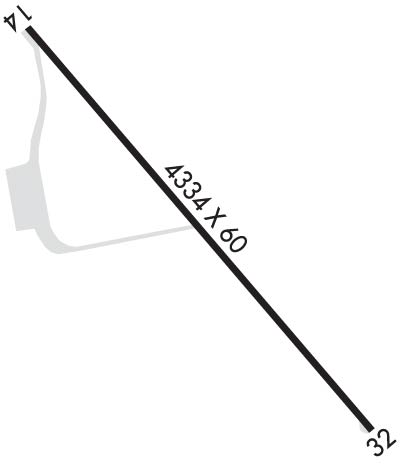
| Lat: N 2947.2 Long: W 09457.2 Elev: 34 Var: -03 Longest Runway: 4334 | ||
| CTAF: 122.8 | ||
| ||||||||||||||||||||||||||||||||||||||||||||
| ||||||||||||||||||||||||||||||||||||||||||||
| Rwy | Rwy | |||||||
| 4334x60 | 3548' | 4334x60 | 3613' | |||||
| Runway ID | Single Wheel | Double Wheel | Double Tandem Wheel | Dual Double Wheel |
| 14/32 | 24,000 | N/A | N/A | N/A |
| These numbers are Advisory and are not limits. The Airport Manager should have more accurate Weight Limits | ||||
 Airport Diagram might not be current. | |
| Facility Name: | BAYTOWN |
| City Name: | BAYTOWN |
| County: | HARRIS |
| State abbrev: | TX |
| State Name: | TEXAS |
| Ownership: | PRIVATELY OWNED |
| Use: | OPEN TO THE PUBLIC |
| Owner's Name: | RACECO INC--BAYTOWN ARPT |
| Address: | 5600 BARKALOO ROAD |
| BAYTOWN, TX 77520 | |
| Owner's Phone: | 281-421-1671 |
| Manager's Name: | CHARLES DANLEY |
| Address: | 5600 BARKALOO ROAD |
| BAYTOWN, TX 77521 | |
| Phone: | 713-303-8638; OR 713-303-8638 (CELL). |
| FAA Region: | SOUTHWEST |
| FAA Field Office: | TEX |
| Date | Sunrise | Sunset |
|---|---|---|
| 09/24/21 Friday | 7:09 | 19:14 |
| 09/25/21 Saturday | 7:10 | 19:13 |
| 09/26/21 Sunday | 7:10 | 19:12 |
| 09/27/21 Monday | 7:11 | 19:10 |
| 09/28/21 Tuesday | 7:11 | 19:09 |
| 09/29/21 Wednesday | 7:12 | 19:08 |
| 09/30/21 Thursday | 7:12 | 19:07 |
| 10/01/21 Friday | 7:13 | 19:06 |
| 10/02/21 Saturday | 7:14 | 19:04 |
| 10/03/21 Sunday | 7:14 | 19:03 |
| 10/04/21 Monday | 7:15 | 19:02 |
| 10/05/21 Tuesday | 7:15 | 19:01 |
| 10/06/21 Wednesday | 7:16 | 19:00 |
| 10/07/21 Thursday | 7:16 | 18:58 |
| Airport Attendance Schedule | 7 Days A Week 0800-1700 |
| Airport Status | OPERATIONAL (This Status can change at any time - please check NOTAMS) |
| Airport Lighting Schedule | ACTVT REIL RWY 14 & 32; PAPI RWY 14 & 32; MIRL RWY 14/32 - CTAF. |
| Airport Storage Available | Tie Downs, Hanger |
| Extra Services Available | Air Ambulance, Flight Instruction |
| Wind Indicator | YES - (lighted) |
| Control Tower | NO |
| CTAF Frequency | 122.800 |
| Unicom Frequency | 122.800 |
| Rotating Beacon Color | CLEAR-GREEN (Light Land Airport) |
| Segmented Circle | YES |
| Landing Fee | NO |
| Airport Inspected | STATE - performed by PRIVATE CONTRACT PERSONNEL |
| Inspection Date | 04/24/2020 |
| Type of Fuel Available | Grade 100LL, JET A |
| Airframe Repair Service | MAJOR |
| Power Plant Repair Service | MAJOR |
| Latitude | N2947.2 |
| Longitude | W09457.2 (ESTIMATED) |
| Arpt Elevation | 33ft (SURVEYED) |
| Magnetic Variation | 03E |
| 3 miles N | of BAYTOWN |
| Traffic Pattern Altitude | |
| Sectional Chart | HOUSTON |
| Operations (Reported) | Yearly | Avg. Daily |
|---|---|---|
| General Aviation Transient | 10950 | 30 |
| General Aviation Local | 10950 | 30 |
| Air Taxi | 0 | 0 |
| Commerical | 0 | 0 |
| Commuter | 0 | 0 |
| Military | 0 | 0 |
| Aircraft based on Field | |
|---|---|
| General Aviation Singles | 32 |
| General Aviation Multi | 12 |
| Jet Aircraft | 2 |
| General Aviation Helicopters | 3 |
| Military Aircraft | 0 |
| Gliders | 0 |
| Ultralights | 0 |
| FSS on field | NO |
| FSS tie-in | MONTGOMERY COUNTY |
| FSS Phone | 1-800-WX-BRIEF |
| Who issues Notams | CXO |
| Notam D service at airport | YES |
| ARTCC Name | HOUSTON |
| Airport Certification | |
| Aircraft Rescue & Firefighting Index | None |
| Airport of Entry | No |
| Custom Landing Rights | No |
| Joint Civil/Military | No |
| Military Landing rights | No |
| THIS AIRPORT HAS BEEN SURVEYED BY THE NATIONAL GEODETIC SURVEY. |
| FOR CD CTC HOUSTON APCH AT 281-443-5844 TO CNL IFR CALL 281-443-5888. |
Airport Communications & Frequencies:
| ||||||||||||||
| Runway: 14 | Runway: 32 | ||
| Mag heading: | 140° | Mag heading: | 320° |
| Rwy Slope: | -.15% Down | Rwy Slope: | .15% Up |
| Approach: | Approach: | ||
| Pattern: | Left Traffic | Pattern: | Left Traffic |
| Markings: | NONPRECISION INSTRUMENT | Markings: | NONPRECISION INSTRUMENT |
| Marking Condition: | FAIR | Marking Condition: | FAIR |
| Arresting Dev: | Arresting Dev: | ||
| Lat & Long: | N2947.4 W09457.4 | Lat. & Long.: | N2946.9 W09456.9 |
| Elev: | 33.8 ft. MSL | Elev: | 27.4 ft. MSL |
| TCH: | 20 ft. AGL | TCH: | 20 ft. AGL |
| Visual Glide Path: | 3.00 degrees | Visual Glide Path: | 3.00 degrees |
| Displaced Threshold: | 786 feet | Displaced Threshold: | 721 feet |
| Touchdown Zone: | YES | Touchdown Zone: | YES |
| Touchdown Elev.: | 33.8 feet | Touchdown Elev.: | 28.0 feet |
| Visual Glide Slope: | 2-Light PAPI on LEFT side of Runway | Visual Glide Slope: | 2-Light PAPI on LEFT side of Runway |
| RVR Equipment: | RVR Equipment: | ||
| RVV Equipment: | NO | RVV Equipment: | NO |
| Approach Lights: | Approach Lights: | ||
| REIL: | YES | REIL: | YES |
| Centerline Lights: | NO | Centerline Lights: | NO |
| Touchdown lights: | NO | Touchdown lights: | NO |
| Runway Category: | Runway with a Non-precision Approach having visibility minimums greater than 3/4 mile | Runway Category: | Runway with a Non-precision Approach having visibility minimums greater than 3/4 mile |
| Declared Distances: | TORA:4088' TODA:4088' ASDA:4088' LDA:3320' | Declared Distances: | TORA:4003' TODA:4003' ASDA:4003' LDA:3283' |
| Obstructions: | ROAD | Obstructions: | PLINE |
| Marked: | NOT Marked/Lighted | Marked: | MARKED |
| Clearance slope: | APCH SLOPE 11:1 TO DSPLCD THR OVR 76 FT TREES, 900 FT DSTC, 385 L. | Clearance slope: | APCH SLOPE TO RWY 32 APCH SLOPE 20:1 TO DSPLCD THR OVR 23 FT TREES, 463 FT DSTC, 260 FT L. |
| Obstruction height: | 15 feet AGL | Obstruction height: | 20 feet AGL |
| Dist. from runway: | 201 feet | Dist. from runway: | 200 feet |
| Centerline offset: | 131 left of centerline | Centerline offset: | |
| Comments: | +15 FT RD 65 FT FM THR 250 FT L EXTDD CNTRLN; 6 FT FENCE FM 120 FT FM THR ACRS EXTDD CNTRLN. | Comments: | 15 FT RD 0-199 FT DSTC FM 131 FT L - 185 FT R. |
Thanks for using FltPlan.com
all rights reserved © 1999-2021 by Flight Plan LLC
