| WESTCHESTER COUNTY WHITE PLAINS NY |
| |
| Lat: N 4104.0 Long: W 07342.5 Elev: 439 Var: +13 Longest Runway: 6549 | ||
| Clr Del: 127.25 TWR CL Dept. ATIS: 133.8 Arr. ATIS: 133.8 Ground: 121.82 Tower: 118.57 | ||
| |||||||||||||||||||||||||||||||||||||||||||||||||||||||||||||||||||||
| |||||||||||||||||||||||||||||||||||||||||||||||||||||||||||||||||||||
| |||||||||||||||||||||||||||||||||||||||||||||||||||||||||||||||||||||
| |||||||||||||||||||||||||||||||||||||||||||||||||||||||||||||||||||||
| |||||||||||||||||||||||||||||||||||||||||||||||||||||||||||||||||||||
| |||||||||||||||||||||||||||||||||||||||||||||||||||||||||||||||||||||
| |||||||||||||||||||||||||||||||||||||||||||||||||||||||||||||||||||||
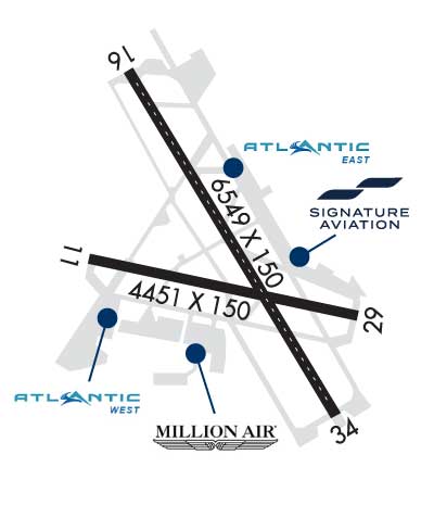
| Rwy | Rwy | |||||||
| 4451x150 | 4451' | 4451x150 | 3159' | |||||
| 6549x150 | 6549' | 109.70 - 161° | 6549x150 | 6549' | 109.70 - 342° | |||
| Runway ID | Single Wheel | Double Wheel | Double Tandem Wheel | Dual Double Wheel |
| 11/29 | 70,000 | 120,000 | 120,000 | N/A |
| 16/34 | N/A | 120,000 | N/A | N/A |
| These numbers are Advisory and are not limits. The Airport Manager should have more accurate Weight Limits | ||||
 Airport Diagram might not be current. | |
| Facility Name: | WESTCHESTER COUNTY |
| City Name: | WHITE PLAINS |
| County: | WESTCHESTER |
| State abbrev: | NY |
| State Name: | NEW YORK |
| Ownership: | PUBLICLY OWNED |
| Use: | OPEN TO THE PUBLIC |
| Owner's Name: | COUNTY OF WESTCHESTER |
| Address: | COUNTY OFFICE BLDG |
| WHITE PLAINS, NY 10604 | |
| Owner's Phone: | 914-995-4856 |
| Manager's Name: | PETER SCHERRER |
| Address: | 240 AIRPORT ROAD SUITE 202 |
| WHITE PLAINS, NY 10604 | |
| Phone: | 914-995-4850 |
| FAA Region: | EASTERN |
| FAA Field Office: | NYC |

| Date | Sunrise | Sunset |
|---|---|---|
| 09/24/21 Friday | 6:44 | 18:49 |
| 09/25/21 Saturday | 6:45 | 18:47 |
| 09/26/21 Sunday | 6:46 | 18:46 |
| 09/27/21 Monday | 6:47 | 18:44 |
| 09/28/21 Tuesday | 6:48 | 18:42 |
| 09/29/21 Wednesday | 6:49 | 18:41 |
| 09/30/21 Thursday | 6:50 | 18:39 |
| 10/01/21 Friday | 6:51 | 18:37 |
| 10/02/21 Saturday | 6:52 | 18:36 |
| 10/03/21 Sunday | 6:53 | 18:34 |
| 10/04/21 Monday | 6:54 | 18:32 |
| 10/05/21 Tuesday | 6:55 | 18:31 |
| 10/06/21 Wednesday | 6:56 | 18:29 |
| 10/07/21 Thursday | 6:57 | 18:27 |
| Airport Attendance Schedule | CONTINUOUS |
| Airport Status | OPERATIONAL (This Status can change at any time - please check NOTAMS) |
| Airport Lighting Schedule | WHEN ATCT CLSD ACTVT MALSR RWY 16; REIL RWY 11 & 34; TDZ LGTS RWY 16; CNTRLN LGTS RWY 16/34; HIRL RWY 16/34; MIRL RWY 11/29; TWY LGTS - CTAF. |
| Airport Storage Available | Tie Downs, Hanger |
| Extra Services Available | Avionics, Cargo Handling, Charter, Flight Instruction, Aircraft Rental, Aircraft Sales |
| Wind Indicator | YES - (lighted) |
| Control Tower | YES |
| CTAF Frequency | 118.575 |
| Unicom Frequency | 122.950 |
| Rotating Beacon Color | CLEAR-GREEN (Light Land Airport) |
| Segmented Circle | NO |
| Landing Fee | YES |
| Airport Inspected | FEDERAL - performed by STATE AERONAUTICAL PERSONNEL |
| Inspection Date | 07/07/2021 |
| Type of Fuel Available | Grade 100LL, JET A (freeze point -40C) |
| Airframe Repair Service | MAJOR |
| Power Plant Repair Service | MAJOR |
| Latitude | N4104.0 |
| Longitude | W07342.5 (ESTIMATED) |
| Arpt Elevation | 439ft (SURVEYED) |
| Magnetic Variation | 13W |
| 3 miles NE | of WHITE PLAINS |
| Traffic Pattern Altitude | |
| Sectional Chart | NEW YORK |
| Operations (Reported) | Yearly | Avg. Daily |
|---|---|---|
| General Aviation Transient | 51400 | 141 |
| General Aviation Local | 41037 | 112 |
| Air Taxi | 4269 | 12 |
| Commerical | 3548 | 10 |
| Commuter | 0 | 0 |
| Military | 100 | 0 |
| Aircraft based on Field | |
|---|---|
| General Aviation Singles | 135 |
| General Aviation Multi | 19 |
| Jet Aircraft | 99 |
| General Aviation Helicopters | 10 |
| Military Aircraft | 0 |
| Gliders | 0 |
| Ultralights | 0 |
| FSS on field | NO |
| FSS tie-in | NEW YORK |
| FSS Phone | 1-800-WX-BRIEF |
| Who issues Notams | HPN |
| Notam D service at airport | YES |
| ARTCC Name | NEW YORK |
| Airport Certification | AIRPORT RECEIVING SCHEDULED AIR CARRIER SERVICE FROM CARRIERS CERTIFICATED BY THE CIVIL AERONAUTICS BOARD |
| Aircraft Rescue & Firefighting Index | AIRPORT HAS A CERTIFICATE UNDER CFR PART 139 |
| Airport of Entry | No |
| Custom Landing Rights | YES |
| Joint Civil/Military | No |
| Military Landing rights | YES |
| NATIONAL PLAN OF INTEGRATED AIRPORT SYSTEMS (NPIAS) |
| GRANT AGREEMENTS UNDER FAAP/ADAP/AIP |
| COMPLIANCE WITH ACCESSIBILITY TO THE HANDICAPPED |
| ASSURANCES PURSUANT TO TITLE VI, CIVIL RIGHTS ACT OF 1964 |
| AGREEMENT UNDER DLAND OR DCLA HAS EXPIRED. |
| NOISE ABATEMENT PROC IN EFCT CTC ARPT MGMT 914-995-4861. |
| BE ALERT: GND EQUIP OPRG ADJ TO EAST SIDE OF TWY ALPHA BTN TWY G AND TWY F. |
| EQUIP AND MTRLS STAGED ADJ TO SOUTHERN EDGE OF HNGR 6 RAMP. |
| FOUR DSGND HEL RTES IN USE FOR NOISE ABATEMENT. |
| ATC CLNC RQRD FOR PUSHBACK ONTO MOV AREAS. |
| MOWING WITHIN SAFETY AREAS OF ALL RWYS AND TWYS MAY THRU NOV. |
| BIRDS & OTHER WILDLIFE ON & INVOF ARPT. |
| SN REMOVAL EQUIP OPRG ON ALL ACFT MOV AREAS NOV THRU APR. |
| RWY 29 CLSD TO LDG ACFT MORE THAN 12500 LBS. |
| HNGR D3 RAMP ADJ TO ACTV PAX LOADING AREA AT MAIN TRML RAMP, ACFT REQSTD USE MNM THRUST AND AVOID EXCESS PWR AND JET BLAST. |
| FOR CD WHEN ATCT CLSD CTC NEW YORK APCH ON 126.4, IF UNA CALL 516-683-2849. |
| RWY 11/29 CLSD TO SKED ACR OPS WITH MORE THAN 9 PAX SEATS AND NON SKED ACR OPS WITH MORE THAN 30 PAX SEATS EXC FOR TAX. |
| ACFT OPRG WITH MGTOW OVR 120000 LBS MUST HAVE PRIOR PERMISSION, TO BE GRANTED BY AMGR OR DESIGNEE 914-995-4856. ALL APVD ACFT MUST CTC ARPT OPNS (OPEN 24/7) ON UNICOM FREQ: 122.95 WITH ACTUAL TKOF & LDG WTS. |
Airport Communications & Frequencies:
| |||||||||||||||||||||||||||||||||||||||
| Runway: 11 | Runway: 29 | ||
| Mag heading: | 115° | Mag heading: | 295° |
| Rwy Slope: | -.21% Down | Rwy Slope: | .21% Up |
| Approach: | Approach: | ||
| Pattern: | Left Traffic | Pattern: | Left Traffic |
| Markings: | BASIC | Markings: | BASIC |
| Marking Condition: | GOOD; RWY 11 AIMING POINT MARKINGS. | Marking Condition: | GOOD |
| Arresting Dev: | Arresting Dev: | ||
| Lat & Long: | N4104.0 W07342.9 | Lat. & Long.: | N4103.9 W07342.0 |
| Elev: | 397.2 ft. MSL | Elev: | 387.7 ft. MSL |
| TCH: | 54 ft. AGL | TCH: | |
| Visual Glide Path: | 3.00 degrees | Visual Glide Path: | |
| Displaced Threshold: | No | Displaced Threshold: | 1292 feet |
| Touchdown Zone: | YES | Touchdown Zone: | YES |
| Touchdown Elev.: | 399.0 feet | Touchdown Elev.: | 399.2 feet |
| Visual Glide Slope: | 4-Light PAPI on LEFT side of Runway | Visual Glide Slope: | |
| RVR Equipment: | RVR Equipment: | ||
| RVV Equipment: | NO | RVV Equipment: | NO |
| Approach Lights: | Approach Lights: | ||
| REIL: | YES | REIL: | NO |
| Centerline Lights: | NO | Centerline Lights: | NO |
| Touchdown lights: | NO | Touchdown lights: | NO |
| Runway Category: | Runway with a Visual Approach | Runway Category: | Runway with a Visual Approach |
| Declared Distances: | TORA:4451' TODA:4451' ASDA:4451' LDA:4451' | Declared Distances: | TORA:4451' TODA:4451' ASDA:4451' LDA:3159' |
| Obstructions: | Obstructions: | TREES | |
| Marked: | Marked: | NOT Marked/Lighted | |
| Clearance slope: | 20:1 | Clearance slope: | 4:1; APCH RATIO 25:1 TO DSPLCD THR. |
| Obstruction height: | Obstruction height: | 71 feet AGL | |
| Dist. from runway: | Dist. from runway: | 527 feet | |
| Centerline offset: | Centerline offset: | 15 feet right of centerline | |
| Comments: | Comments: |
| Runway: 16 | Runway: 34 | ||
| Mag heading: | 163° | Mag heading: | 343° |
| Rwy Slope: | -.90% Down | Rwy Slope: | .90% Up |
| Approach: | ILS/DME | Approach: | ILS/DME |
| Pattern: | Left Traffic | Pattern: | Left Traffic |
| Markings: | PRECISION INSTRUMENT | Markings: | PRECISION INSTRUMENT |
| Marking Condition: | GOOD | Marking Condition: | GOOD |
| Arresting Dev: | Arresting Dev: | ||
| Lat & Long: | N4104.5 W07342.8 | Lat. & Long.: | N4103.6 W07342.1 |
| Elev: | 439.0 ft. MSL | Elev: | 379.8 ft. MSL |
| TCH: | 55 ft. AGL | TCH: | 56 ft. AGL |
| Visual Glide Path: | 3.00 degrees | Visual Glide Path: | 3.00 degrees |
| Displaced Threshold: | No | Displaced Threshold: | No |
| Touchdown Zone: | YES | Touchdown Zone: | YES |
| Touchdown Elev.: | 439.0 feet | Touchdown Elev.: | 401.2 feet |
| Visual Glide Slope: | 4-Light PAPI on LEFT side of Runway | Visual Glide Slope: | 4-Light PAPI on LEFT side of Runway |
| RVR Equipment: | TOUCHDOWN | RVR Equipment: | ROLLOUT |
| RVV Equipment: | NO | RVV Equipment: | NO |
| Approach Lights: | MALSR - 1,400 foot medium intensity approach lighting system with runway alignment indicator lights | Approach Lights: | |
| REIL: | NO | REIL: | YES |
| Centerline Lights: | YES | Centerline Lights: | YES |
| Touchdown lights: | YES | Touchdown lights: | NO |
| Runway Category: | Precision Instrument Runway | Runway Category: | Precision Instrument Runway |
| Declared Distances: | TORA:6549' TODA:6549' ASDA:6549' LDA:6549' | Declared Distances: | TORA:6549' TODA:6549' ASDA:6549' LDA:6549' |
| Obstructions: | Obstructions: | BLDG | |
| Marked: | Marked: | LIGHTED | |
| Clearance slope: | 50:1 | Clearance slope: | 37:1 |
| Obstruction height: | Obstruction height: | 87 feet AGL | |
| Dist. from runway: | Dist. from runway: | 3460 feet | |
| Centerline offset: | Centerline offset: | 600 feet right of centerline | |
| Comments: | Comments: |
Thanks for using FltPlan.com
all rights reserved © 1999-2021 by Flight Plan LLC