
| WILLIAM P HOBBY HOUSTON TX |
| |
| Lat: N 2938.7 Long: W 09516.7 Elev: 46 Var: -03 Longest Runway: 7602 | ||
| Clr Del: 125.45 Dept. ATIS: 124.6 Arr. ATIS: 124.6 Ground: 121.9 Tower: 118.7 | ||

| |||||||||||||||||||||||||||||||||||||||||||||||||||||||||||||||||||||
| |||||||||||||||||||||||||||||||||||||||||||||||||||||||||||||||||||||
| |||||||||||||||||||||||||||||||||||||||||||||||||||||||||||||||||||||
| |||||||||||||||||||||||||||||||||||||||||||||||||||||||||||||||||||||
| |||||||||||||||||||||||||||||||||||||||||||||||||||||||||||||||||||||
| |||||||||||||||||||||||||||||||||||||||||||||||||||||||||||||||||||||
| |||||||||||||||||||||||||||||||||||||||||||||||||||||||||||||||||||||
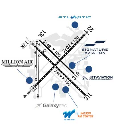
| FBOs at nearby airports who want your business: | |||||||||||||||||
| |||||||||||||||||
| |||||||||||||||||
| |||||||||||||||||
| Rwy | Rwy | |||||||
| 7602x150 | 7602' | 109.90 - 040° | 7602x150 | 7602' | 109.90 - 220° | |||
| 5148x100 | 5148' | 5148x100 | 5148' | |||||
| 7599x150 | 6565' | 111.30 - 130° | 7599x150 | 7599' | 111.30 - 310° | |||
| 6000x150 | 6000' | 6000x150 | 6000' | |||||
| Runway ID | Single Wheel | Double Wheel | Double Tandem Wheel | Dual Double Wheel |
| 04/22 | 75,000 | 200,000 | 400,000 | N/A |
| 13L/31R | 30,000 | 45,000 | 80,000 | N/A |
| 13R/31L | 75,000 | 195,000 | 220,000 | N/A |
| 17/35 | 75,000 | 121,000 | 195,000 | N/A |
| These numbers are Advisory and are not limits. The Airport Manager should have more accurate Weight Limits | ||||
 Airport Diagram might not be current. | |
| Facility Name: | WILLIAM P HOBBY |
| City Name: | HOUSTON |
| County: | HARRIS |
| State abbrev: | TX |
| State Name: | TEXAS |
| Ownership: | PUBLICLY OWNED |
| Use: | OPEN TO THE PUBLIC |
| Owner's Name: | CITY OF HOUSTON |
| Address: | 16930 JF KENNEDY BLVD |
| HOUSTON, TX 77032 | |
| Owner's Phone: | 281-233-3000 |
| Manager's Name: | STEVE RUNGE |
| Address: | PO BOX 60106 |
| HOUSTON, TX 77205 | |
| Phone: | 281-233-7351 |
| FAA Region: | SOUTHWEST |
| FAA Field Office: | TEX |
| Date | Sunrise | Sunset |
|---|---|---|
| 09/24/21 Friday | 7:10 | 19:15 |
| 09/25/21 Saturday | 7:11 | 19:14 |
| 09/26/21 Sunday | 7:11 | 19:13 |
| 09/27/21 Monday | 7:12 | 19:12 |
| 09/28/21 Tuesday | 7:13 | 19:11 |
| 09/29/21 Wednesday | 7:13 | 19:09 |
| 09/30/21 Thursday | 7:14 | 19:08 |
| 10/01/21 Friday | 7:14 | 19:07 |
| 10/02/21 Saturday | 7:15 | 19:06 |
| 10/03/21 Sunday | 7:15 | 19:04 |
| 10/04/21 Monday | 7:16 | 19:03 |
| 10/05/21 Tuesday | 7:17 | 19:02 |
| 10/06/21 Wednesday | 7:17 | 19:01 |
| 10/07/21 Thursday | 7:18 | 19:00 |
| Airport Attendance Schedule | CONTINUOUS |
| Airport Status | OPERATIONAL (This Status can change at any time - please check NOTAMS) |
| Airport Lighting Schedule | SS-SR |
| Airport Storage Available | Tie Downs, Hanger |
| Extra Services Available | Air Freight, Air Ambulance, Avionics, Cargo Handling, Charter, Flight Instruction, Aircraft Rental |
| Wind Indicator | YES - (unlit) |
| Control Tower | YES |
| CTAF Frequency | |
| Unicom Frequency | 122.950 |
| Rotating Beacon Color | CLEAR-GREEN (Light Land Airport) |
| Segmented Circle | NO |
| Landing Fee | NO |
| Airport Inspected | FEDERAL - performed by FAA AIRPORTS FIELD PERSONNEL |
| Inspection Date | 05/21/2021 |
| Type of Fuel Available | Grade 100LL, JET A (freeze point -40C), JET A-1 (freeze point -50C) |
| Airframe Repair Service | MINOR |
| Power Plant Repair Service | MINOR |
| Latitude | N2938.7 |
| Longitude | W09516.7 (ESTIMATED) |
| Arpt Elevation | 46ft (SURVEYED) |
| Magnetic Variation | 03E |
| 8 miles SE | of HOUSTON |
| Traffic Pattern Altitude | |
| Sectional Chart | HOUSTON |
| Operations (Reported) | Yearly | Avg. Daily |
|---|---|---|
| General Aviation Transient | 43160 | 118 |
| General Aviation Local | 0 | 0 |
| Air Taxi | 29968 | 82 |
| Commerical | 78857 | 216 |
| Commuter | 0 | 0 |
| Military | 1855 | 5 |
| Aircraft based on Field | |
|---|---|
| General Aviation Singles | 9 |
| General Aviation Multi | 9 |
| Jet Aircraft | 172 |
| General Aviation Helicopters | 8 |
| Military Aircraft | 0 |
| Gliders | 0 |
| Ultralights | 0 |
| FSS on field | NO |
| FSS tie-in | MONTGOMERY COUNTY |
| FSS Phone | 1-800-WX-BRIEF |
| Who issues Notams | HOU |
| Notam D service at airport | YES |
| ARTCC Name | HOUSTON |
| Airport Certification | AIRPORT RECEIVING SCHEDULED AIR CARRIER SERVICE FROM CARRIERS CERTIFICATED BY THE CIVIL AERONAUTICS BOARD |
| Aircraft Rescue & Firefighting Index | AIRPORT HAS A CERTIFICATE UNDER CFR PART 139 |
| Airport of Entry | No |
| Custom Landing Rights | YES |
| Joint Civil/Military | No |
| Military Landing rights | YES |
| NATIONAL PLAN OF INTEGRATED AIRPORT SYSTEMS (NPIAS) |
| GRANT AGREEMENTS UNDER FAAP/ADAP/AIP |
| ASSURANCES PURSUANT TO TITLE VI, CIVIL RIGHTS ACT OF 1964 |
| AGREEMENT UNDER DLAND OR DCLA HAS EXPIRED. |
| NMRS BIRDS ON AND IN VCNTY OF ARPT. |
| CUST RAMP HAS MULT OBSTNS; LARGE ACFT WILL BE ASGND AN ALTN AREA BY ATCT. |
| ASDE-X IN USE. OPR TRANSPONDERS WITH ALT RPRTG MODE AND ADS-B (IF EQUIPPED) ENABLED ON ALL ARPT SFCS. |
| ARPT CLSD TO ACFT WITH WING SPAN OVER 125 FT EXCP 24 HRS PPR CALL OPNS 713-417-5710. |
| PILOTS/CREW SHOULD BE AWARE OF DEP TURNS IN EXCESS OF 180 DEGS. READ BACK OF DRCTN OF TURNS IS HIGHLY ENCOURAGED. |
| TWY G CNTRLN TO PARKED ACFT ON WEST SIDE ONLY 68 FT. TWY G CNTRLN TO EDGE OF ADJ SVC VEHICLE ROAD ON WEST SIDE ONLY 48 FT. |
| DUE TO COMPLEX RWY CONFIGN; WHEN TAX TO THRS 13L & 13R CHECK COMPASS HDG BFR DEPARTING. |
| ACFT SOUTHBOUND ON TWY C TO RWY 31L THR USE EXTREME CARE; TWY C MAKES A 45 DEG DOGLEG TO THE LEFT XNG TWY K. |
| ACFT IN TKOF PTN ON RWY 22 BE ALERT FOR POSS RADIO INTFC OR NULL ON FREQ 118.7. USE UPPER ANT IF SO EQUIPPED. |
| RWY 17/3 5 CLSD PERMLY PER NOTAM. |
Airport Communications & Frequencies:
| ||||||||||||||||||||||||||||||||||||||||||||||||||||||||||||||||||
| Runway: 04 | Runway: 22 | ||
| Mag heading: | 41° | Mag heading: | 221° |
| Rwy Slope: | -.04% Down | Rwy Slope: | .04% Up |
| Approach: | ILS/DME | Approach: | LOC/DME |
| Pattern: | Left Traffic | Pattern: | Left Traffic |
| Markings: | PRECISION INSTRUMENT | Markings: | PRECISION INSTRUMENT |
| Marking Condition: | GOOD | Marking Condition: | GOOD |
| Arresting Dev: | Arresting Dev: | ||
| Lat & Long: | N2938.3 W09517.1 | Lat. & Long.: | N2939.2 W09516.1 |
| Elev: | 42.0 ft. MSL | Elev: | 38.9 ft. MSL |
| TCH: | 58 ft. AGL | TCH: | 49 ft. AGL |
| Visual Glide Path: | 3.00 degrees | Visual Glide Path: | 3.00 degrees |
| Displaced Threshold: | No | Displaced Threshold: | No |
| Touchdown Zone: | YES | Touchdown Zone: | YES |
| Touchdown Elev.: | 44.1 feet | Touchdown Elev.: | 41.0 feet |
| Visual Glide Slope: | 4-Light PAPI on RIGHT side of Runway | Visual Glide Slope: | 4-Light PAPI on LEFT side of Runway |
| RVR Equipment: | TOUCHDOWN-MIDFIELD-ROLLOUT | RVR Equipment: | TOUCHDOWN-MIDFIELD-ROLLOUT |
| RVV Equipment: | NO | RVV Equipment: | NO |
| Approach Lights: | ALSF2 - standard 2,400 foot high intensity approach lighting system with sequenced flashers, Category II or III | Approach Lights: | MALS - 1,400 foot medium intensity approach lighting system |
| REIL: | NO | REIL: | NO |
| Centerline Lights: | YES | Centerline Lights: | YES |
| Touchdown lights: | YES | Touchdown lights: | NO |
| Runway Category: | Precision Instrument Runway | Runway Category: | D |
| Declared Distances: | TORA:7602' TODA:7602' ASDA:7602' LDA:7602' | Declared Distances: | TORA:7602' TODA:7602' ASDA:7602' LDA:7602' |
| Obstructions: | Obstructions: | POLE | |
| Marked: | Marked: | NOT Marked/Lighted | |
| Clearance slope: | 50:1 | Clearance slope: | 33:1 |
| Obstruction height: | Obstruction height: | 125 feet AGL | |
| Dist. from runway: | Dist. from runway: | 4400 feet | |
| Centerline offset: | Centerline offset: | 1000 feet left of centerline | |
| Comments: | Comments: |
| Runway: 13L | Runway: 31R | ||
| Mag heading: | 131° | Mag heading: | 311° |
| Rwy Slope: | -.10% Down | Rwy Slope: | .10% Up |
| Approach: | Approach: | ||
| Pattern: | Left Traffic | Pattern: | Left Traffic |
| Markings: | BASIC | Markings: | BASIC |
| Marking Condition: | GOOD | Marking Condition: | GOOD |
| Arresting Dev: | Arresting Dev: | ||
| Lat & Long: | N2939.2 W09517.0 | Lat. & Long.: | N2938.6 W09516.3 |
| Elev: | 44.9 ft. MSL | Elev: | 39.6 ft. MSL |
| TCH: | 60 ft. AGL | TCH: | |
| Visual Glide Path: | 3.00 degrees | Visual Glide Path: | |
| Displaced Threshold: | No | Displaced Threshold: | No |
| Touchdown Zone: | YES | Touchdown Zone: | YES |
| Touchdown Elev.: | 44.9 feet | Touchdown Elev.: | 44.0 feet |
| Visual Glide Slope: | 4-Light PAPI on LEFT side of Runway | Visual Glide Slope: | |
| RVR Equipment: | RVR Equipment: | ||
| RVV Equipment: | NO | RVV Equipment: | NO |
| Approach Lights: | Approach Lights: | ||
| REIL: | NO | REIL: | NO |
| Centerline Lights: | NO | Centerline Lights: | NO |
| Touchdown lights: | NO | Touchdown lights: | NO |
| Runway Category: | Runway with a Visual Approach | Runway Category: | Runway with a Visual Approach |
| Declared Distances: | TORA:5148' TODA:5148' ASDA:5148' LDA:5148' | Declared Distances: | TORA:5148' TODA:5148' ASDA:5148' LDA:5148' |
| Runway: 13R | Runway: 31L | ||
| Mag heading: | 131° | Mag heading: | 311° |
| Rwy Slope: | -.04% Down | Rwy Slope: | .04% Up |
| Approach: | ILS/DME | Approach: | ILS/DME |
| Pattern: | Left Traffic | Pattern: | Left Traffic |
| Markings: | PRECISION INSTRUMENT | Markings: | PRECISION INSTRUMENT |
| Marking Condition: | GOOD | Marking Condition: | GOOD |
| Arresting Dev: | Arresting Dev: | ||
| Lat & Long: | N2939.1 W09517.1 | Lat. & Long.: | N2938.2 W09516.1 |
| Elev: | 44.6 ft. MSL | Elev: | 41.3 ft. MSL |
| TCH: | 52 ft. AGL | TCH: | 76 ft. AGL |
| Visual Glide Path: | 3.00 degrees | Visual Glide Path: | 3.00 degrees |
| Displaced Threshold: | 1034 feet | Displaced Threshold: | No |
| Touchdown Zone: | YES | Touchdown Zone: | YES |
| Touchdown Elev.: | 46.2 feet | Touchdown Elev.: | 42.5 feet |
| Visual Glide Slope: | 4-Light PAPI on RIGHT side of Runway | Visual Glide Slope: | 4-Light PAPI on LEFT side of Runway |
| RVR Equipment: | TOUCHDOWN | RVR Equipment: | TOUCHDOWN |
| RVV Equipment: | NO | RVV Equipment: | NO |
| Approach Lights: | MALSR - 1,400 foot medium intensity approach lighting system with runway alignment indicator lights | Approach Lights: | |
| REIL: | NO | REIL: | YES |
| Centerline Lights: | YES | Centerline Lights: | YES |
| Touchdown lights: | YES | Touchdown lights: | YES |
| Runway Category: | Precision Instrument Runway | Runway Category: | Precision Instrument Runway |
| Declared Distances: | TORA:7599' TODA:7599' ASDA:7599' LDA:6565' | Declared Distances: | TORA:7599' TODA:7599' ASDA:7599' LDA:7599' |
| Obstructions: | POLE | Obstructions: | ROAD |
| Marked: | NOT Marked/Lighted | Marked: | NOT Marked/Lighted |
| Clearance slope: | 2:1; APCH RATIO 36:1 TO DSPLCD THR. | Clearance slope: | |
| Obstruction height: | 37 feet AGL | Obstruction height: | 13 feet AGL |
| Dist. from runway: | 310 feet | Dist. from runway: | 200 feet |
| Centerline offset: | 500 right of centerline | Centerline offset: | 500 feet right of centerline |
| Comments: | Comments: |
| Runway: 17 | Runway: 35 | ||
| Mag heading: | 176° | Mag heading: | 356° |
| Rwy Slope: | -.03% Down | Rwy Slope: | .03% Up |
| Approach: | Approach: | ||
| Pattern: | Left Traffic | Pattern: | Left Traffic |
| Markings: | NONPRECISION INSTRUMENT | Markings: | NONPRECISION INSTRUMENT |
| Marking Condition: | GOOD | Marking Condition: | GOOD |
| Arresting Dev: | Arresting Dev: | ||
| Lat & Long: | N2939.1 W09517.1 | Lat. & Long.: | N2938.2 W09517.1 |
| Elev: | 44.8 ft. MSL | Elev: | 42.9 ft. MSL |
| TCH: | 38 ft. AGL | TCH: | 41 ft. AGL |
| Visual Glide Path: | 3.00 degrees | Visual Glide Path: | 3.00 degrees |
| Displaced Threshold: | No | Displaced Threshold: | No |
| Touchdown Zone: | YES | Touchdown Zone: | YES |
| Touchdown Elev.: | 46.2 feet | Touchdown Elev.: | 46.0 feet |
| Visual Glide Slope: | 4-BOX VASI ON LEFT SIDE OF RUNWAY | Visual Glide Slope: | 4-Light PAPI on RIGHT side of Runway |
| RVR Equipment: | RVR Equipment: | ||
| RVV Equipment: | NO | RVV Equipment: | NO |
| Approach Lights: | Approach Lights: | ||
| REIL: | NO | REIL: | YES |
| Centerline Lights: | NO | Centerline Lights: | NO |
| Touchdown lights: | NO | Touchdown lights: | NO |
| Runway Category: | Runway with a Non-precision Approach having visibility minimums greater than 3/4 mile | Runway Category: | Runway with a Non-precision Approach having visibility minimums greater than 3/4 mile |
| Declared Distances: | TORA:6000' TODA:6000' ASDA:6000' LDA:6000' | Declared Distances: | TORA:6000' TODA:6000' ASDA:6000' LDA:6000' |
| Obstructions: | POLE | Obstructions: | BLDG |
| Marked: | NOT Marked/Lighted | Marked: | NOT Marked/Lighted |
| Clearance slope: | 38:1 | Clearance slope: | 18:1 |
| Obstruction height: | 32 feet AGL | Obstruction height: | 25 feet AGL |
| Dist. from runway: | 1428 feet | Dist. from runway: | 653 feet |
| Centerline offset: | 120 right of centerline | Centerline offset: | 225 feet right of centerline |
| Comments: | Comments: |
Thanks for using FltPlan.com
all rights reserved © 1999-2021 by Flight Plan LLC