
| CAMPBELL AAF FT CAMPBELL/HOPKINSV KY |
| |
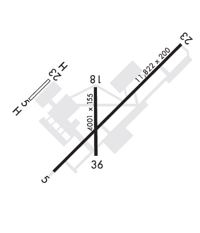
| Lat: N 3640.4 Long: W 08729.5 Elev: 571 Var: +01 Longest Runway: 10926 | ||
| Clr Del: 138.8 Dept. ATIS: 125.17 Arr. ATIS: 125.17 Ground: 121.8 Tower: 120.9 | ||
| ||
| Rwy | Rwy | |||||||
| 10926x150 | 10926' | 10926x150 | 10926' | 111.90 - 225° | ||||
| 4500x100 | 4500' | 4500x100 | 4500' | |||||
| Runway ID | Single Wheel | Double Wheel | Double Tandem Wheel | Dual Double Wheel |
| 05/23 | N/A | N/A | N/A | N/A |
| 18/36 | N/A | N/A | N/A | N/A |
| These numbers are Advisory and are not limits. The Airport Manager should have more accurate Weight Limits | ||||
 Airport Diagram might not be current. | |
| Facility Name: | CAMPBELL AAF (FORT CAMPBELL) |
| City Name: | FORT CAMPBELL/HOPKINSVILLE |
| County: | CHRISTIAN |
| State abbrev: | KY |
| State Name: | KENTUCKY |
| Ownership: | ARMY OWNED |
| Use: | PRIVATE |
| Owner's Name: | US ARMY ATCA-ASO |
| Address: | 9325 GUNSTON ROAD |
| FT BELVOIR, VA 22060 | |
| Owner's Phone: | 502-798-7146 |
| Manager's Name: | AIRFIELD OPS |
| Address: | |
| FORT CAMPBELL | |
| Phone: | 270-798-7146/47 |
| FAA Region: | SOUTHERN |
| FAA Field Office: | MEM |
| Date | Sunrise | Sunset |
|---|---|---|
| 09/24/21 Friday | 6:39 | 18:44 |
| 09/25/21 Saturday | 6:40 | 18:43 |
| 09/26/21 Sunday | 6:41 | 18:41 |
| 09/27/21 Monday | 6:42 | 18:40 |
| 09/28/21 Tuesday | 6:43 | 18:38 |
| 09/29/21 Wednesday | 6:43 | 18:37 |
| 09/30/21 Thursday | 6:44 | 18:35 |
| 10/01/21 Friday | 6:45 | 18:34 |
| 10/02/21 Saturday | 6:46 | 18:32 |
| 10/03/21 Sunday | 6:47 | 18:31 |
| 10/04/21 Monday | 6:48 | 18:29 |
| 10/05/21 Tuesday | 6:48 | 18:28 |
| 10/06/21 Wednesday | 6:49 | 18:26 |
| 10/07/21 Thursday | 6:50 | 18:25 |
| Airport Attendance Schedule | CONTINUOUS; SEE FLIP AP/1 FLT HAZ & SUPPLEMENTARY ARPT |
| Airport Status | OPERATIONAL (This Status can change at any time - please check NOTAMS) |
| Airport Lighting Schedule | SS-SR |
| Airport Storage Available | NONE |
| Extra Services Available | NONE |
| Wind Indicator | NONE |
| Control Tower | YES |
| CTAF Frequency | 122.950 |
| Unicom Frequency | |
| Rotating Beacon Color | SPLIT-CLEAR-GREEN (LIGHTED MILITARY AIRPORT) |
| Segmented Circle | NO |
| Landing Fee |
| Airport Inspected | No Inspection Data Available performed by the OWNER |
| Inspection Date | Unknown |
| Type of Fuel Available | ++ |
| Airframe Repair Service | None |
| Power Plant Repair Service | None |
| Latitude | N3640.4 |
| Longitude | W08729.5 (ESTIMATED) |
| Arpt Elevation | 571ft (SURVEYED) |
| Magnetic Variation | 01W |
| 2 miles NW | of FORT CAMPBELL/HOPKINSVILLE |
| Traffic Pattern Altitude | |
| Sectional Chart | ST LOUIS |
| Operations (Reported) | Yearly | Avg. Daily |
|---|---|---|
| General Aviation Transient | 0 | 0 |
| General Aviation Local | 0 | 0 |
| Air Taxi | 0 | 0 |
| Commerical | 0 | 0 |
| Commuter | 0 | 0 |
| Military | 0 | 0 |
| Aircraft based on Field | |
|---|---|
| General Aviation Singles | 0 |
| General Aviation Multi | 0 |
| Jet Aircraft | 0 |
| General Aviation Helicopters | 0 |
| Military Aircraft | 0 |
| Gliders | 0 |
| Ultralights | 0 |
| FSS on field | NO |
| FSS tie-in | LOUISVILLE |
| FSS Phone | 1-800-WX-BRIEF |
| Who issues Notams | HOP |
| Notam D service at airport | YES |
| ARTCC Name | MEMPHIS |
| Airport Certification | |
| Aircraft Rescue & Firefighting Index | None |
| Airport of Entry | YES; CSTMS/AG/IMG: AVBL 72 HR PPR; MIL ACFT ONLY - D635-7146. |
| Custom Landing Rights | No |
| Joint Civil/Military | No |
| Military Landing rights | No |
| OIL: O-123-128-148-156 SP |
| PPR FOR TSNT ACFT SVC OR FUEL - BASE OPS 130.65 OR 230.1. |
| CTN: R3701 & SMALL ARMS RANGE 1000 YD DEP END RWY 23; DEER HAZ; PJE. |
| MISC: NO HGR TSNT ACFT. BASE OPS H24 - DSN 635-7146/7147/C270-798-7146/47. |
| JASU: 3(M-32A-86) 3(AM32-95) 1(MC-2A) |
| MISC: NO F/W PRKG ON FREEDOM RAMP. |
| MISC: WX OBSN AUTO & AUGMENTED H24; FCST H24 - EAGLE CON. |
| RSTD: TWY K NORTH OF RWY 05/23 ROTARY WING ONLY. |
| EAGLE CON - CLSD FM 1200Z SAT - 1200Z MON -6(-5DT); CTC PRIOR TO ENTRY R3701, R3702 - 139.9 285.700. |
| BACH HEL APCH HDG 155 DEG; DEP HDG 335 DEG; CTC APCH ON 118.1; VFR ONLY. LTD USE BY AIR AMBULANCE AVOID OVFT OF HOSP, WILSON THEATER, GARRISON HQ, HOUSING AREA AND SCHOOLS. PCL VHF 122.8. |
| NAVAID: HXW TACAN & FK NDB UNMONITORED 0400-1400Z++. |
| FOR CD WHEN UNA VIA FREQ CTC CAMPBELL APCH AT 270-798-6441. |
| NO CLASSIFIED OR COMSEC STORAGE AVBL. |
| TWY A, C, D, E, G, H, L & M PAVED SHOULDERS NA. |
| RWY 05/2 3 RWY-5H L5, 13, 50 RWY-23. SERVICE-2(AM32-95) NAVAIDS-593/3°'W. AVOID OVFT OF WILSON THEATER |
Airport Communications & Frequencies:
| |||||||||||||||||||||||||||||||||
| Runway: 05 | Runway: 23 | ||
| Mag heading: | N/A | Mag heading: | N/A |
| Rwy Slope: | .16% Up | Rwy Slope: | -.16% Down |
| Approach: | Approach: | ILS/DME | |
| Pattern: | Left Traffic | Pattern: | Right Traffic |
| Markings: | PRECISION INSTRUMENT | Markings: | PRECISION INSTRUMENT |
| Marking Condition: | GOOD | Marking Condition: | FAIR |
| Arresting Dev: | Arresting Dev: | ||
| Lat & Long: | N3639.8 W08730.2 | Lat. & Long.: | N3641.1 W08728.6 |
| Elev: | 553.8 ft. MSL | Elev: | 571.0 ft. MSL |
| TCH: | 59 ft. AGL | TCH: | 78 ft. AGL |
| Visual Glide Path: | 3.00 degrees | Visual Glide Path: | 3.00 degrees |
| Displaced Threshold: | No | Displaced Threshold: | No |
| Touchdown Zone: | YES | Touchdown Zone: | YES |
| Touchdown Elev.: | 555.1 feet | Touchdown Elev.: | 570.9 feet |
| Visual Glide Slope: | 4-Light PAPI on LEFT side of Runway | Visual Glide Slope: | 4-Light PAPI on LEFT side of Runway |
| RVR Equipment: | RVR Equipment: | TOUCHDOWN | |
| RVV Equipment: | NO | RVV Equipment: | NO |
| Approach Lights: | Approach Lights: | SSALR - simplified short approach lighting system with runway alignment indicator lights | |
| REIL: | NO | REIL: | NO |
| Centerline Lights: | NO | Centerline Lights: | NO |
| Touchdown lights: | NO | Touchdown lights: | NO |
| Runway Category: | Runway Category: | ||
| Declared Distances: | Declared Distances: |
| Runway: 18 | Runway: 36 | ||
| Mag heading: | N/A | Mag heading: | N/A |
| Rwy Slope: | -.17% Down | Rwy Slope: | .17% Up |
| Approach: | Approach: | ||
| Pattern: | Left Traffic | Pattern: | Left Traffic |
| Markings: | NONPRECISION INSTRUMENT | Markings: | BASIC |
| Marking Condition: | GOOD | Marking Condition: | POOR |
| Arresting Dev: | Arresting Dev: | ||
| Lat & Long: | N3640.6 W08729.8 | Lat. & Long.: | N3639.9 W08729.8 |
| Elev: | 561.4 ft. MSL | Elev: | 553.6 ft. MSL |
| TCH: | 50 ft. AGL | TCH: | 49 ft. AGL |
| Visual Glide Path: | 3.00 degrees | Visual Glide Path: | 3.00 degrees |
| Displaced Threshold: | No | Displaced Threshold: | No |
| Touchdown Zone: | YES | Touchdown Zone: | YES |
| Touchdown Elev.: | 562.4 feet | Touchdown Elev.: | 555.1 feet |
| Visual Glide Slope: | 4-Light PAPI on LEFT side of Runway | Visual Glide Slope: | 4-Light PAPI on LEFT side of Runway |
| RVR Equipment: | RVR Equipment: | ||
| RVV Equipment: | NO | RVV Equipment: | NO |
| Approach Lights: | Approach Lights: | ||
| REIL: | NO | REIL: | NO |
| Centerline Lights: | NO | Centerline Lights: | NO |
| Touchdown lights: | NO | Touchdown lights: | NO |
| Runway Category: | Runway Category: | ||
| Declared Distances: | Declared Distances: |
Thanks for using FltPlan.com
all rights reserved © 1999-2021 by Flight Plan LLC
