| LEA COUNTY RGNL HOBBS NM |
| |
| Lat: N 3241.2 Long: W 10313.1 Elev: 3661 Var: -07 Longest Runway: 8000 | ||
| Dept. ATIS: 119.75 Arr. ATIS: 119.75 AWOS: 119.75 Ground: 121.9 Tower: 120.65 | ||
| ||||||||||||||||||||||||||||||||||||||||||||||||||||||||||||||||||||
| ||||||||||||||||||||||||||||||||||||||||||||||||||||||||||||||||||||
| ||||||||||||||||||||||||||||||||||||||||||||||||||||||||||||||||||||
| ||||||||||||||||||||||||||||||||||||||||||||||||||||||||||||||||||||
| Rwy | Rwy | |||||||
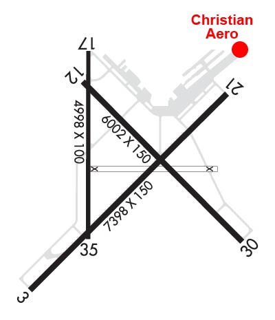
| 8000x150 | 7398' | 108.50 - 038° | 8000x150 | 8000' | ||||
| 6002x150 | 6002' | 6002x150 | 6002' | |||||
| 4370x100 | 3878' | 4370x100 | 4370' | |||||
| Runway ID | Single Wheel | Double Wheel | Double Tandem Wheel | Dual Double Wheel |
| 04/22 | 112,000 | 168,000 | 259,000 | N/A |
| 13/31 | 120,000 | 171,000 | 279,000 | N/A |
| 17/35 | 32,000 | 50,000 | N/A | N/A |
| These numbers are Advisory and are not limits. The Airport Manager should have more accurate Weight Limits | ||||
 Airport Diagram might not be current. | |
| Facility Name: | LEA COUNTY RGNL |
| City Name: | HOBBS |
| County: | LEA |
| State abbrev: | NM |
| State Name: | NEW MEXICO |
| Ownership: | PUBLICLY OWNED |
| Use: | OPEN TO THE PUBLIC |
| Owner's Name: | LEA COUNTY |
| Address: | 100 N MAIN AVE, COURTHOUSE BOX 5C |
| LOVINGTON, NM 88260-4000 | |
| Owner's Phone: | 575-396-8521 |
| Manager's Name: | COREY NEEDHAM |
| Address: | 100 N MAIN AVE, COURTHOUSE BOX 5C |
| LOVINGTON, NM 88260-4000 | |
| Phone: | 575-391-2934 |
| FAA Region: | SOUTHWEST |
| FAA Field Office: | LNM |
| Date | Sunrise | Sunset |
|---|---|---|
| 06/08/26 Monday | 5:45 | 19:59 |
| 06/09/26 Tuesday | 5:45 | 20:00 |
| 06/10/26 Wednesday | 5:44 | 20:00 |
| 06/11/26 Thursday | 5:44 | 20:01 |
| 06/12/26 Friday | 5:44 | 20:01 |
| 06/13/26 Saturday | 5:44 | 20:01 |
| 06/14/26 Sunday | 5:44 | 20:02 |
| 06/15/26 Monday | 5:45 | 20:02 |
| 06/16/26 Tuesday | 5:45 | 20:02 |
| 06/17/26 Wednesday | 5:45 | 20:03 |
| 06/18/26 Thursday | 5:45 | 20:03 |
| 06/19/26 Friday | 5:45 | 20:03 |
| 06/20/26 Saturday | 5:45 | 20:04 |
| 06/21/26 Sunday | 5:45 | 20:04 |
| Airport Attendance Schedule | 7 Days A Week 0600-1700; FICONS UNMON WHEN UNATNDD. |
| Airport Status | OPERATIONAL (This Status can change at any time - please check NOTAMS) |
| Airport Lighting Schedule | WHEN ATCT CLSD REIL RWY 22; HIRL RWY 04/22; MIRL RWY 13/31 PRESET LOW INTST; TO INCR INTST & ACTVT MALSR RWY 04; PAPI RWY 22, 13, & 31; TWY LGTS - CTAF. |
| Airport Storage Available | Tie Downs, Hanger |
| Extra Services Available | Air Freight, Air Ambulance, Cargo Handling |
| Wind Indicator | YES - (lighted) |
| Control Tower | YES |
| CTAF Frequency | 120.650 |
| Unicom Frequency | 122.950 |
| Rotating Beacon Color | WG |
| Segmented Circle | YES |
| Landing Fee | NO |
| Airport Inspected | FEDERAL - performed by FAA AIRPORTS FIELD PERSONNEL |
| Inspection Date | 12/19/2025 |
| Type of Fuel Available | Grade 100LL, JET A (freeze point -40C) |
| Airframe Repair Service | None |
| Power Plant Repair Service | MINOR |
| Latitude | N3241.2 |
| Longitude | W10313.1 (ESTIMATED) |
| Arpt Elevation | 3660ft (SURVEYED) |
| Magnetic Variation | 07E |
| 4 miles W | of HOBBS |
| Traffic Pattern Altitude | |
| Sectional Chart | ALBUQUERQUE |
| Operations (Reported) | Yearly | Avg. Daily |
|---|---|---|
| General Aviation Transient | 0 | 0 |
| General Aviation Local | 0 | 0 |
| Air Taxi | 0 | 0 |
| Commerical | 0 | 0 |
| Commuter | 0 | 0 |
| Military | 0 | 0 |
| Aircraft based on Field | |
|---|---|
| General Aviation Singles | 0 |
| General Aviation Multi | 0 |
| Jet Aircraft | 0 |
| General Aviation Helicopters | 0 |
| Military Aircraft | 0 |
| Gliders | 0 |
| Ultralights | 0 |
| FSS on field | NO |
| FSS tie-in | ALBUQUERQUE |
| FSS Phone | 1-800-WX-BRIEF |
| Who issues Notams | HOB |
| Notam D service at airport | YES |
| ARTCC Name | FORT WORTH |
| Airport Certification | AIRPORT RECEIVING SCHEDULED AIR CARRIER SERVICE FROM CARRIERS CERTIFICATED BY THE CIVIL AERONAUTICS BOARD |
| Aircraft Rescue & Firefighting Index | AIRPORT HAS A CERTIFICATE UNDER CFR PART 139 |
| Airport of Entry | No |
| Custom Landing Rights | No |
| Joint Civil/Military | No |
| Military Landing rights | YES |
| NATIONAL PLAN OF INTEGRATED AIRPORT SYSTEMS (NPIAS) |
| GRANT AGREEMENTS UNDER FAAP/ADAP/AIP |
| ASSURANCES PURSUANT TO TITLE VI, CIVIL RIGHTS ACT OF 1964 |
| AGREEMENT UNDER DLAND OR DCLA HAS EXPIRED. |
| FOR CD IF UNA TO CTC ON FSS FREQ, CTC FORT WORTH ARTCC AT 817-858-7584. |
| RWY 04/2 2 PCR VALUE: 410/F/C/X/T |
| RWY 13/3 1 PCR VALUE: 200/F/C/X/T |
| RWY 17/3 5 PCR VALUE: 80/F/D/X/T |
Airport Communications & Frequencies:
| |||||||||||||||||||||
| Runway: 04 | Runway: 22 | ||
| Mag heading: | 38° | Mag heading: | 218° |
| Rwy Slope: | -.09% Down | Rwy Slope: | .09% Up |
| Approach: | ILS/DME | Approach: | |
| Pattern: | Left Traffic | Pattern: | Left Traffic |
| Markings: | PRECISION INSTRUMENT | Markings: | NONPRECISION INSTRUMENT |
| Marking Condition: | GOOD | Marking Condition: | GOOD |
| Arresting Dev: | Arresting Dev: | ||
| Lat & Long: | N3240.7 W10313.6 | Lat. & Long.: | N3241.6 W10312.5 |
| Elev: | 3653.9 ft. MSL | Elev: | 3646.4 ft. MSL |
| TCH: | TCH: | 44 ft. AGL | |
| Visual Glide Path: | Visual Glide Path: | 3.00 degrees | |
| Displaced Threshold: | 602 feet | Displaced Threshold: | No |
| Touchdown Zone: | YES | Touchdown Zone: | YES |
| Touchdown Elev.: | 3652.4 feet | Touchdown Elev.: | 3649.3 feet |
| Visual Glide Slope: | Visual Glide Slope: | 4-Light PAPI on LEFT side of Runway | |
| RVR Equipment: | RVR Equipment: | ||
| RVV Equipment: | NO | RVV Equipment: | NO |
| Approach Lights: | MALSR - 1,400 foot medium intensity approach lighting system with runway alignment indicator lights | Approach Lights: | |
| REIL: | NO | REIL: | YES |
| Centerline Lights: | NO | Centerline Lights: | NO |
| Touchdown lights: | NO | Touchdown lights: | NO |
| Runway Category: | Precision Instrument Runway | Runway Category: | Runway with a Non-precision Approach having visibility minimums greater than 3/4 mile |
| Declared Distances: | TORA:8000' TODA:8000' ASDA:8000' LDA:7398' | Declared Distances: | TORA:8000' TODA:8000' ASDA:8000' LDA:8000' |
| Runway: 13 | Runway: 31 | ||
| Mag heading: | 128° | Mag heading: | 308° |
| Rwy Slope: | -.38% Down | Rwy Slope: | .38% Up |
| Approach: | Approach: | ||
| Pattern: | Left Traffic | Pattern: | Left Traffic |
| Markings: | NONPRECISION INSTRUMENT | Markings: | NONPRECISION INSTRUMENT |
| Marking Condition: | GOOD | Marking Condition: | GOOD |
| Arresting Dev: | Arresting Dev: | ||
| Lat & Long: | N3241.6 W10313.3 | Lat. & Long.: | N3240.9 W10312.5 |
| Elev: | 3660.5 ft. MSL | Elev: | 3637.6 ft. MSL |
| TCH: | 49 ft. AGL | TCH: | 41 ft. AGL |
| Visual Glide Path: | 3.00 degrees | Visual Glide Path: | 3.00 degrees |
| Displaced Threshold: | No | Displaced Threshold: | No |
| Touchdown Zone: | YES | Touchdown Zone: | YES |
| Touchdown Elev.: | 3660.5 feet | Touchdown Elev.: | 3649.0 feet |
| Visual Glide Slope: | 4-Light PAPI on LEFT side of Runway | Visual Glide Slope: | 4-Light PAPI on RIGHT side of Runway |
| RVR Equipment: | RVR Equipment: | ||
| RVV Equipment: | NO | RVV Equipment: | NO |
| Approach Lights: | Approach Lights: | ||
| REIL: | NO | REIL: | NO |
| Centerline Lights: | NO | Centerline Lights: | NO |
| Touchdown lights: | NO | Touchdown lights: | NO |
| Runway Category: | Runway with a Visual Approach | Runway Category: | Runway with a Visual Approach |
| Declared Distances: | TORA:6002' TODA:6002' ASDA:6002' LDA:6002' | Declared Distances: | TORA:6002' TODA:6002' ASDA:6002' LDA:6002' |
| Runway: 17 | Runway: 35 | ||
| Mag heading: | 173° | Mag heading: | 353° |
| Rwy Slope: | -.21% Down | Rwy Slope: | .21% Up |
| Approach: | Approach: | ||
| Pattern: | Left Traffic | Pattern: | Left Traffic |
| Markings: | PRECISION INSTRUMENT | Markings: | NONPRECISION INSTRUMENT |
| Marking Condition: | GOOD | Marking Condition: | GOOD |
| Arresting Dev: | Arresting Dev: | ||
| Lat & Long: | N3241.8 W10313.2 | Lat. & Long.: | N3241.0 W10313.3 |
| Elev: | 3659.7 ft. MSL | Elev: | 3650.7 ft. MSL |
| TCH: | TCH: | ||
| Visual Glide Path: | Visual Glide Path: | ||
| Displaced Threshold: | 492 feet | Displaced Threshold: | No |
| Touchdown Zone: | YES | Touchdown Zone: | YES |
| Touchdown Elev.: | 3660.7 feet | Touchdown Elev.: | 3658.9 feet |
| Visual Glide Slope: | Visual Glide Slope: | ||
| RVR Equipment: | RVR Equipment: | ||
| RVV Equipment: | NO | RVV Equipment: | NO |
| Approach Lights: | Approach Lights: | ||
| REIL: | NO | REIL: | NO |
| Centerline Lights: | NO | Centerline Lights: | NO |
| Touchdown lights: | NO | Touchdown lights: | NO |
| Runway Category: | Runway with a Visual Approach | Runway Category: | Runway with a Visual Approach |
| Declared Distances: | TORA:4370' TODA:4370' ASDA:4370' LDA:3878' | Declared Distances: | TORA:4370' TODA:3418' ASDA:3878' LDA:3878' |
Thanks for using FltPlan.com
all rights reserved © 1999-2026 by Flight Plan LLC