
| HENDERSON-OXFORD OXFORD NC |
| |
| Lat: N 3621.7 Long: W 07831.8 Elev: 526 Var: +09 Longest Runway: 5501 | ||
| Clr Del: 135.07 GCO AWOS: 118.62 CTAF: 122.8 | ||
| ||||||||||||||||||||||||||||||||
| ||||||||||||||||||||||||||||||||
| ||||||||||||||||||||||||||||||||
| ||||||||||||||||||||||||||||||||
| Rwy | Rwy | |||||||
| 5501x100 | 5501' | 109.75 - 060° | 5501x100 | 5501' | ||||
| Runway ID | Single Wheel | Double Wheel | Double Tandem Wheel | Dual Double Wheel |
| 06/24 | 30,000 | N/A | N/A | N/A |
| These numbers are Advisory and are not limits. The Airport Manager should have more accurate Weight Limits | ||||
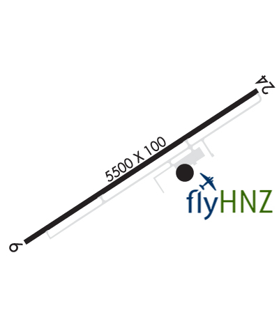 Airport Diagram might not be current. | |
| Facility Name: | HENDERSON/OXFORD |
| City Name: | OXFORD; AND CITY OF HENDERSON. |
| County: | GRANVILLE; AND VANCE CO. |
| State abbrev: | NC |
| State Name: | NORTH CAROLINA |
| Ownership: | PUBLICLY OWNED |
| Use: | OPEN TO THE PUBLIC |
| Owner's Name: | OXFORD-HENDERSON ARPT AUTH |
| Address: | 6514 AIRPORT ROAD |
| OXFORD, NC 27565-6459 | |
| Owner's Phone: | 919-693-5769 |
| Manager's Name: | AMANDA WELSH |
| Address: | 6514 AIRPORT ROAD |
| OXFORD, NC 27565-6459 | |
| Phone: | 919-693-5769 |
| FAA Region: | SOUTHERN |
| FAA Field Office: | MEM |
| Date | Sunrise | Sunset |
|---|---|---|
| 06/07/26 Sunday | 5:56 | 20:30 |
| 06/08/26 Monday | 5:56 | 20:30 |
| 06/09/26 Tuesday | 5:56 | 20:31 |
| 06/10/26 Wednesday | 5:56 | 20:31 |
| 06/11/26 Thursday | 5:56 | 20:32 |
| 06/12/26 Friday | 5:56 | 20:32 |
| 06/13/26 Saturday | 5:56 | 20:33 |
| 06/14/26 Sunday | 5:56 | 20:33 |
| 06/15/26 Monday | 5:56 | 20:33 |
| 06/16/26 Tuesday | 5:56 | 20:34 |
| 06/17/26 Wednesday | 5:56 | 20:34 |
| 06/18/26 Thursday | 5:56 | 20:34 |
| 06/19/26 Friday | 5:56 | 20:35 |
| 06/20/26 Saturday | 5:56 | 20:35 |
| Airport Attendance Schedule | MON-SAT 0800-1700, SUN 1300-1700; UNATTENDED THANKSGIVING & CHRISTMAS DAYS. |
| Airport Status | OPERATIONAL (This Status can change at any time - please check NOTAMS) |
| Airport Lighting Schedule | ACTVT REIL RWY 06; MIRL RWY 06/24 - CTAF. PAPI RWY 06 & 24 OPR CONSLY. |
| Airport Storage Available | Tie Downs |
| Extra Services Available | Flight Instruction, Aircraft Rental |
| Wind Indicator | YES - (lighted) |
| Control Tower | NO |
| CTAF Frequency | 122.800 |
| Unicom Frequency | 122.800 |
| Rotating Beacon Color | WG |
| Segmented Circle | YES |
| Landing Fee | NO |
| Airport Inspected | STATE - performed by STATE AERONAUTICAL PERSONNEL |
| Inspection Date | 07/01/2023 |
| Type of Fuel Available | Grade 100LL, JET A-1 (icing inhibitor, freeze point -50C); -10FUEL 24 HR CREDIT CARD SVC AVBL. |
| Airframe Repair Service | MAJOR |
| Power Plant Repair Service | MAJOR |
| Latitude | N3621.7 |
| Longitude | W07831.8 (ESTIMATED) |
| Arpt Elevation | 526ft (SURVEYED) |
| Magnetic Variation | 09W |
| 4 miles NE | of OXFORD; AND CITY OF HENDERSON. |
| Traffic Pattern Altitude | |
| Sectional Chart | WASHINGTON |
| Operations (Reported) | Yearly | Avg. Daily |
|---|---|---|
| General Aviation Transient | 0 | 0 |
| General Aviation Local | 0 | 0 |
| Air Taxi | 0 | 0 |
| Commerical | 0 | 0 |
| Commuter | 0 | 0 |
| Military | 0 | 0 |
| Aircraft based on Field | |
|---|---|
| General Aviation Singles | 0 |
| General Aviation Multi | 0 |
| Jet Aircraft | 0 |
| General Aviation Helicopters | 0 |
| Military Aircraft | 0 |
| Gliders | 0 |
| Ultralights | 0 |
| FSS on field | NO |
| FSS tie-in | RALEIGH |
| FSS Phone | 1-800-WX-BRIEF |
| Who issues Notams | HNZ |
| Notam D service at airport | YES |
| ARTCC Name | WASHINGTON |
| Airport Certification | |
| Aircraft Rescue & Firefighting Index | None |
| Airport of Entry | No |
| Custom Landing Rights | No |
| Joint Civil/Military | No |
| Military Landing rights | YES |
| NATIONAL PLAN OF INTEGRATED AIRPORT SYSTEMS (NPIAS) |
| GRANT AGREEMENTS UNDER FAAP/ADAP/AIP |
| ASSURANCES PURSUANT TO TITLE VI, CIVIL RIGHTS ACT OF 1964 |
| RWY 24 HAS 60 FT DROP OFF 325 FT FM THR & 90 FT LEFT & RIGHT FM CNTRLN. |
| RWY 6 HAS 28 FT UNMARKED POWERLINE 1000 FT FM THR ON CNTRLN. |
| NO LINE OF SIGHT BTN RWY ENDS. |
| FOR AFTER HOURS SERVICE CALL 919-693-5769. |
| TREES EAST OF THE ARPT OBSCURE THE ROTG BCN. |
| HOLD LINES ARE LESS THAN 150 FT FROM CNTRLN. |
| RWY 24 HAS 30 FT UNMKD POWERLINE 1000 FT FM THR ON CNTRLN. |
| FOR CD IF UNA VIA GCO CTC RALEIGH APCH AT 919-380-3144. |
| RWY 6 HAS 30 FT DROP-OFF 280 FT FROM THR & 40-60 FT DROP-OFF 75 FT BOTH SIDES OF CNTRLN. |
Airport Communications & Frequencies:
| ||||||||||||||
| Runway: 06 | Runway: 24 | ||
| Mag heading: | 60° | Mag heading: | 240° |
| Rwy Slope: | -.33% Down | Rwy Slope: | .33% Up |
| Approach: | LOCALIZER | Approach: | |
| Pattern: | Left Traffic | Pattern: | Left Traffic |
| Markings: | NONPRECISION INSTRUMENT | Markings: | NONPRECISION INSTRUMENT |
| Marking Condition: | GOOD | Marking Condition: | GOOD |
| Arresting Dev: | Arresting Dev: | ||
| Lat & Long: | N3621.4 W07832.2 | Lat. & Long.: | N3622.0 W07831.4 |
| Elev: | 523.2 ft. MSL | Elev: | 505.1 ft. MSL |
| TCH: | 43 ft. AGL | TCH: | 41 ft. AGL |
| Visual Glide Path: | 3.25 degrees | Visual Glide Path: | 3.00 degrees |
| Displaced Threshold: | No | Displaced Threshold: | No |
| Touchdown Zone: | YES | Touchdown Zone: | YES |
| Touchdown Elev.: | 526.3 feet | Touchdown Elev.: | 522.6 feet |
| Visual Glide Slope: | 4-Light PAPI on LEFT side of Runway | Visual Glide Slope: | 4-Light PAPI on RIGHT side of Runway |
| RVR Equipment: | RVR Equipment: | ||
| RVV Equipment: | NO | RVV Equipment: | NO |
| Approach Lights: | Approach Lights: | ||
| REIL: | YES | REIL: | NO |
| Centerline Lights: | NO | Centerline Lights: | NO |
| Touchdown lights: | NO | Touchdown lights: | NO |
| Runway Category: | Runway with a Non-precision Approach having visibility minimums greater than 3/4 mile | Runway Category: | Runway with a Non-precision Approach having visibility minimums greater than 3/4 mile |
| Declared Distances: | Declared Distances: | ||
| Obstructions: | TREES | Obstructions: | PLINE |
| Marked: | NOT Marked/Lighted | Marked: | NOT Marked/Lighted |
| Clearance slope: | 29:1 | Clearance slope: | 34:1 |
| Obstruction height: | 48 feet AGL | Obstruction height: | 33 feet AGL |
| Dist. from runway: | 1634 feet | Dist. from runway: | 1353 feet |
| Centerline offset: | 63 left of centerline | Centerline offset: | |
| Comments: | Comments: |
Thanks for using FltPlan.com
all rights reserved © 1999-2026 by Flight Plan LLC