
| HEMET-RYAN HEMET CA |
| |
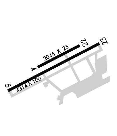
| Lat: N 3344.0 Long: W 11701.3 Elev: 1515 Var: -13 Longest Runway: 4315 | ||
| AWOS: 118.37 CTAF: 123.0 | ||
| ||||||||||||||||||||||||||||||||||||||||||||
| ||||||||||||||||||||||||||||||||||||||||||||
| ||||||||||||||||||||||||||||||||||||||||||||
| Rwy | Rwy | |||||||
| 2014x25 | 2014' | 2014x25 | 2014' | |||||
| 4315x100 | 4315' | 4315x100 | 4315' | |||||
| Runway ID | Single Wheel | Double Wheel | Double Tandem Wheel | Dual Double Wheel |
| 04/22 | N/A | N/A | N/A | N/A |
| 05/23 | 80,000 | 130,000 | N/A | N/A |
| These numbers are Advisory and are not limits. The Airport Manager should have more accurate Weight Limits | ||||
 Airport Diagram might not be current. | |
| Facility Name: | HEMET-RYAN |
| City Name: | HEMET |
| County: | RIVERSIDE |
| State abbrev: | CA |
| State Name: | CALIFORNIA |
| Ownership: | PUBLICLY OWNED |
| Use: | OPEN TO THE PUBLIC |
| Owner's Name: | COUNTY OF RIVERSIDE |
| Address: | 4080 LEMON STREET, 14TH FLOOR |
| RIVERSIDE, CA 92501 | |
| Owner's Phone: | 951-955-9722 |
| Manager's Name: | ANGELA JAMISON |
| Address: | 4080 LEMON STREET, 14TH FLOOR |
| RIVERSIDE, CA 92501 | |
| Phone: | 951-955-9418 |
| FAA Region: | WESTERN-PACIFIC |
| FAA Field Office: | LAX |
| Date | Sunrise | Sunset |
|---|---|---|
| 09/24/21 Friday | 6:37 | 18:42 |
| 09/25/21 Saturday | 6:38 | 18:41 |
| 09/26/21 Sunday | 6:39 | 18:39 |
| 09/27/21 Monday | 6:40 | 18:38 |
| 09/28/21 Tuesday | 6:40 | 18:37 |
| 09/29/21 Wednesday | 6:41 | 18:35 |
| 09/30/21 Thursday | 6:42 | 18:34 |
| 10/01/21 Friday | 6:42 | 18:33 |
| 10/02/21 Saturday | 6:43 | 18:31 |
| 10/03/21 Sunday | 6:44 | 18:30 |
| 10/04/21 Monday | 6:45 | 18:29 |
| 10/05/21 Tuesday | 6:45 | 18:27 |
| 10/06/21 Wednesday | 6:46 | 18:26 |
| 10/07/21 Thursday | 6:47 | 18:25 |
| Airport Attendance Schedule | 7 Days A Week DALGT |
| Airport Status | OPERATIONAL (This Status can change at any time - please check NOTAMS) |
| Airport Lighting Schedule | ACTVT MIRL RY 05/23 & TWY LGTS - CTAF. |
| Airport Storage Available | Tie Downs |
| Extra Services Available | Air Ambulance, Glider, Flight Instruction, Aircraft Rental, Glider Towing |
| Wind Indicator | YES - (lighted) |
| Control Tower | NO |
| CTAF Frequency | 123.000 |
| Unicom Frequency | 123.000 |
| Rotating Beacon Color | CLEAR-GREEN (Light Land Airport) |
| Segmented Circle | YES |
| Landing Fee | NO |
| Airport Inspected | STATE - performed by STATE AERONAUTICAL PERSONNEL |
| Inspection Date | 12/11/2020 |
| Type of Fuel Available | Grade 100LL, JET A (freeze point -40C) |
| Airframe Repair Service | MAJOR |
| Power Plant Repair Service | MAJOR |
| Latitude | N3344.0 |
| Longitude | W11701.3 (ESTIMATED) |
| Arpt Elevation | 1514ft (SURVEYED) |
| Magnetic Variation | 13E |
| 3 miles SW | of HEMET |
| Traffic Pattern Altitude | |
| Sectional Chart | LOS ANGELES |
| Operations (Reported) | Yearly | Avg. Daily |
|---|---|---|
| General Aviation Transient | 28291 | 78 |
| General Aviation Local | 47153 | 129 |
| Air Taxi | 0 | 0 |
| Commerical | 0 | 0 |
| Commuter | 0 | 0 |
| Military | 0 | 0 |
| Aircraft based on Field | |
|---|---|
| General Aviation Singles | 91 |
| General Aviation Multi | 13 |
| Jet Aircraft | 1 |
| General Aviation Helicopters | 7 |
| Military Aircraft | 0 |
| Gliders | 5 |
| Ultralights | 0 |
| FSS on field | NO |
| FSS tie-in | RIVERSIDE |
| FSS Phone | 1-800-WX-BRIEF |
| Who issues Notams | RAL |
| Notam D service at airport | YES |
| ARTCC Name | LOS ANGELES |
| Airport Certification | |
| Aircraft Rescue & Firefighting Index | None |
| Airport of Entry | No |
| Custom Landing Rights | No |
| Joint Civil/Military | No |
| Military Landing rights | YES |
| NATIONAL PLAN OF INTEGRATED AIRPORT SYSTEMS (NPIAS) |
| GRANT AGREEMENTS UNDER FAAP/ADAP/AIP |
| SURPLUS PROPERTY AGREEMENT UNDER PUBLIC LAW 289 |
| ASSURANCES PURSUANT TO TITLE VI, CIVIL RIGHTS ACT OF 1964 |
| AIR TANKER ACTIVITY MAY-NOV; FOREST SVC FIRE FIGHTING ACFT FREQUENTLY FLY THE CONVENTIONAL RECTANGULAR PAT WITH FOUR 90 DEG CLEARING TURNS ENTERING THE DOWN WIND LEG ABEAM MIDPOINT OF RY. |
| WATCH FOR USFS FIRE FIGHTING ACFT. |
| GLIDER, ULTRALIGHT ACT NORTH SIDE OF ARPT. |
| FOR CD CTC SOCAL APCH AT 800-448-3724. |
Airport Communications & Frequencies:
| ||||||||||||||||||||||
| Runway: 04 | Runway: 22 | ||
| Mag heading: | 50° | Mag heading: | 230° |
| Rwy Slope: | .29% Up | Rwy Slope: | -.29% Down |
| Approach: | Approach: | ||
| Pattern: | Left Traffic | Pattern: | Right Traffic |
| Markings: | BASIC | Markings: | BASIC |
| Marking Condition: | GOOD | Marking Condition: | GOOD |
| Arresting Dev: | Arresting Dev: | ||
| Lat & Long: | N3344.0 W11701.4 | Lat. & Long.: | N3344.2 W11701.1 |
| Elev: | 1506.6 ft. MSL | Elev: | 1512.4 ft. MSL |
| TCH: | TCH: | ||
| Visual Glide Path: | Visual Glide Path: | ||
| Displaced Threshold: | No | Displaced Threshold: | No |
| Touchdown Zone: | YES | Touchdown Zone: | YES |
| Touchdown Elev.: | 1512.4 feet | Touchdown Elev.: | 1512.4 feet |
| Visual Glide Slope: | Visual Glide Slope: | ||
| RVR Equipment: | RVR Equipment: | ||
| RVV Equipment: | NO | RVV Equipment: | NO |
| Approach Lights: | Approach Lights: | ||
| REIL: | NO | REIL: | NO |
| Centerline Lights: | NO | Centerline Lights: | NO |
| Touchdown lights: | NO | Touchdown lights: | NO |
| Runway Category: | Runway with a Visual Approach | Runway Category: | Runway with a Visual Approach |
| Declared Distances: | Declared Distances: |
| Runway: 05 | Runway: 23 | ||
| Mag heading: | 50° | Mag heading: | 230° |
| Rwy Slope: | .21% Up | Rwy Slope: | -.21% Down |
| Approach: | Approach: | ||
| Pattern: | Right Traffic | Pattern: | Left Traffic |
| Markings: | NONPRECISION INSTRUMENT | Markings: | BASIC |
| Marking Condition: | GOOD | Marking Condition: | GOOD |
| Arresting Dev: | Arresting Dev: | ||
| Lat & Long: | N3343.8 W11701.7 | Lat. & Long.: | N3344.2 W11701.0 |
| Elev: | 1505.7 ft. MSL | Elev: | 1514.7 ft. MSL |
| TCH: | TCH: | 26 ft. AGL | |
| Visual Glide Path: | Visual Glide Path: | 3.00 degrees | |
| Displaced Threshold: | No | Displaced Threshold: | No |
| Touchdown Zone: | YES | Touchdown Zone: | YES |
| Touchdown Elev.: | 1512.5 feet | Touchdown Elev.: | 1514.8 feet |
| Visual Glide Slope: | Visual Glide Slope: | 2-Light PAPI on LEFT side of Runway | |
| RVR Equipment: | RVR Equipment: | ||
| RVV Equipment: | NO | RVV Equipment: | NO |
| Approach Lights: | Approach Lights: | ||
| REIL: | NO | REIL: | NO |
| Centerline Lights: | NO | Centerline Lights: | NO |
| Touchdown lights: | NO | Touchdown lights: | NO |
| Runway Category: | Runway with a Non-precision Approach having visibility minimums greater than 3/4 mile | Runway Category: | Runway with a Visual Approach |
| Declared Distances: | Declared Distances: |
Thanks for using FltPlan.com
all rights reserved © 1999-2021 by Flight Plan LLC
