
| HOLLOMAN AFB (PRIVATE) ALAMOGORDO NM |
| |
| Lat: N 3251.1 Long: W 10606.5 Elev: 4093 Var: -10 Longest Runway: 12922 | ||
| Clr Del: 126.7 Dept. ATIS: 273.5 Arr. ATIS: 273.5 Ground: 127.05 Tower: 119.3 | ||
| |||||
| |||||
|
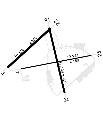
| Rwy | Rwy | |||||||
| 10578x300 | 10578' | 10578x300 | 10578' | 111.70 - 219° | ||||
| 12922x150 | 12922' | 12922x150 | 12922' | |||||
| 12134x150 | 12134' | 108.90 - 157° | 12134x150 | 12134' | ||||
| Runway ID | Single Wheel | Double Wheel | Double Tandem Wheel | Dual Double Wheel |
| 04/22 | N/A | N/A | N/A | N/A |
| 07/25 | N/A | N/A | N/A | N/A |
| 16/34 | N/A | N/A | N/A | N/A |
| These numbers are Advisory and are not limits. The Airport Manager should have more accurate Weight Limits | ||||
 Airport Diagram might not be current. | |
| Facility Name: | HOLLOMAN AFB |
| City Name: | ALAMOGORDO |
| County: | OTERO |
| State abbrev: | NM |
| State Name: | NEW MEXICO |
| Ownership: | AIR FORCE OWNED |
| Use: | PRIVATE |
| Owner's Name: | USAF |
| Address: | 49TH CSG/TAC/ |
| HOLLOMAN AFB, NM 88330 | |
| Owner's Phone: | |
| Manager's Name: | BASE OPERATIONS |
| Address: | 49TH CSG/TAC/ |
| HOLLOMAN AFB, NM 88330 | |
| Phone: | 575-572-5411 |
| FAA Region: | SOUTHWEST |
| FAA Field Office: | LNM |
| Date | Sunrise | Sunset |
|---|---|---|
| 09/24/21 Friday | 6:54 | 18:59 |
| 09/25/21 Saturday | 6:54 | 18:57 |
| 09/26/21 Sunday | 6:55 | 18:56 |
| 09/27/21 Monday | 6:56 | 18:55 |
| 09/28/21 Tuesday | 6:56 | 18:53 |
| 09/29/21 Wednesday | 6:57 | 18:52 |
| 09/30/21 Thursday | 6:58 | 18:51 |
| 10/01/21 Friday | 6:58 | 18:49 |
| 10/02/21 Saturday | 6:59 | 18:48 |
| 10/03/21 Sunday | 7:00 | 18:47 |
| 10/04/21 Monday | 7:00 | 18:45 |
| 10/05/21 Tuesday | 7:01 | 18:44 |
| 10/06/21 Wednesday | 7:02 | 18:43 |
| 10/07/21 Thursday | 7:03 | 18:41 |
| Airport Attendance Schedule | |
| Airport Status | OPERATIONAL (This Status can change at any time - please check NOTAMS) |
| Airport Lighting Schedule | SS-SR |
| Airport Storage Available | NONE |
| Extra Services Available | NONE |
| Wind Indicator | YES - (unlit) |
| Control Tower | YES |
| CTAF Frequency | |
| Unicom Frequency | |
| Rotating Beacon Color | CLEAR-GREEN (Light Land Airport) |
| Segmented Circle | NO |
| Landing Fee |
| Airport Inspected | No Inspection Data Available performed by the OWNER |
| Inspection Date | Unknown |
| Type of Fuel Available | JET B (wide-cut turbine fuel, icing inhibitor, freeze point -50C) |
| Airframe Repair Service | MAJOR |
| Power Plant Repair Service | MAJOR |
| Latitude | N3251.1 |
| Longitude | W10606.5 (ESTIMATED) |
| Arpt Elevation | 4093ft (ESTIMATED) |
| Magnetic Variation | 10E |
| 6 miles SW | of ALAMOGORDO |
| Traffic Pattern Altitude | OVERHEAD 6100 FT /300 KT. |
| Sectional Chart | ALBUQUERQUE |
| Operations (Reported) | Yearly | Avg. Daily |
|---|---|---|
| General Aviation Transient | 0 | 0 |
| General Aviation Local | 0 | 0 |
| Air Taxi | 0 | 0 |
| Commerical | 0 | 0 |
| Commuter | 0 | 0 |
| Military | 0 | 0 |
| Aircraft based on Field | |
|---|---|
| General Aviation Singles | 0 |
| General Aviation Multi | 0 |
| Jet Aircraft | 0 |
| General Aviation Helicopters | 0 |
| Military Aircraft | 1 |
| Gliders | 0 |
| Ultralights | 0 |
| FSS on field | NO |
| FSS tie-in | ALBUQUERQUE |
| FSS Phone | 1-800-WX-BRIEF |
| Who issues Notams | HMN |
| Notam D service at airport | YES |
| ARTCC Name | ALBUQUERQUE |
| Airport Certification | |
| Aircraft Rescue & Firefighting Index | None |
| Airport of Entry | No |
| Custom Landing Rights | No |
| Joint Civil/Military | No |
| Military Landing rights | No |
| CAUTION: MT TERRAIN 10 NM E AND 20 NM W. |
| CAUTION: PORTIONS OF ARPT NOT VIS FR TWR. EXIT RWY 22 ON TWY R HOLD SHORT TWY G. |
| ILS/RADAR: RWY 16 ILS AVBL FOR CIR APCH TO RWY 22. |
| MISC: AERODROME WX SVC AVBL MON-SAT 0600-0100Z++, SAT 1400-2100Z++. CLSD SUN, HOL OR WHEN AFLD IS NOTAM CLSD. AUTO OBS AVBL DUR NON-OPR HRS. |
| SERVICE-A-GEAR: RWY 04-22 BAK-12B (MID FLD) AND RWY 25 APCH BAK-12B 30 MIN PN. BAK-15 LCTD RWY 16 UNDER-RUN UNSVC. NETS AVBL TO BE RAISED AT PILOT REQ. RWY 34 HOOK BAK-12 B (60 FT OVRN) UNIT IS NOT BI-DIRECTIONAL. |
| CAUTION: AFLD HAS HI POTENTIAL FOR FOD FR ENG BLAST, MINIMIZE THRUST DUR GRD OPS. |
| MISC: ONLY SINGLE APCH AND FULL STOP LDG AUTHORIZED FOR TRAN ACFT. |
| RSTD: RWY 16-34 RSTD TO ACFT WITH WINGSPAN 175 FT OR LESS. |
| CAUTION: COPTER ARR/DEP AVOID HOVER OVER UNPREPARED SFC. |
| SERVICE-LGT: RWY 16-34 DIST REM MRK OTS. |
| TWY GOLF EDGE LGTS LOCATED 150 FT SOUTH OF TWY GOLF PAVEMENT EDGE INVOF CLSD END OF RWY (EOR) GULF. |
| REMARKS-RSTD: CTC AM OPS DSN 572-5411, C575-572-5411 TO SKED. |
| UNITS WISHING TO FORWARD DEPLOY TO HOLLOMAN AFB CTC 49 WG/XP DSN 572-7483 FOR WG APVL. |
| CAUTION: BIRD HAZARD: WETLANDS AND LAKE LOCATED LESS THAN 1 NM S OF RWY 34 APCH END. BASH PHASE II IN EFF: 1 MAR-31 MAY AND 1 AUG-31 OCT. |
| RSTD: ALL ACFT RQRG CARGO AND/OR PAX SVC RQR TO CTC 49 LRS AT DSN 572-0905, C575-572-0905. |
| RSTD: NO ENG RUNNING ON/OFF LOADS WITHOUT PRIOR COORD WITH 49 LRS. |
| CAUTION: NON-FRANGIBLE SIGN LCTD ON TWY F/TWY E INT LESS THAN 100 FT FR TWY F CNTRLN ON S SIDE. |
| SERVICE-A-GEAR: CAUTION: RWY 25 APCH BAK-12 INCREASED STRIKE HAZ TO F-16 CONFIGURED WITH EXTERNAL CNTRLN STORES/TANKS. |
| SERVICE-LGT: GATED THLD LGT ALL RWY. |
| BEARING STRENGTH RWY 04-22: ST155 SBTT590 DDT837. |
| BEARING STRENGTH RWY 07-25: ST155. |
| BEARING STRENGTH RWY 16-34: ST155 SBTT590. |
| CAUTION: UNCTL VEH ON MOVEMENT AREA. |
| MISC: STD AETC RSRS APPLIED, NON-AETC ASGN ACFT RQR WRITTEN APVL. |
| MISC: RADAR MONITORING NOT AVBL ALL RWY. |
| JASU: 2(MD-3) 2(MA-1A) 3(MC-1) 1(MC-1A) 1(M32A-60). |
| FUEL: A++. |
| FLUID: SP LHOX LOX. |
| OIL: O-128-133-148-156 SOAP. |
| A: OPR 1000-0100Z++ MON-SAT. |
| PPR MUST BE REQ 72 HR PRIOR BUT NO EARLIER THAN 7 DAYS PRIOR TO ARR. CTC AFLD MGMT DSN 572-5411/5412, C575-572-5411/5412. PPR VALID +/- 30 MIN PRIOR/AFTER ETA. EARLY/LATE ARR/DEP MUST BE RE-COORD WITH AFLD MGMT. |
| SEE FLIP AP/1 SUPPLEMENTARY ARPT |
| MISC: TWY GOLF WIDTH 150 FT WT BEARING. |
| RSTD: HEAVY ACFT SHOULD EXPECT TO LAND RWY 22. |
| MISC: WX OBSN SITE LTD 220-350 DEG DUE TO BLDG; NGT OBSN LTD DUE TO HI INST LGT. SVC UNAVBL WHEN AFLD NOTAM CLSD. WX DSN 572-3924/5 C575-572-3924/5. FOR SBY SVC DUR NON-OPR WX HR CTC 25 OWS DSN 228-6674. |
| MISC: TRANSIENT ACFT LAST PRIORITY ON REFUELING DUE TO REFUELING MECHANICAL PROBLEMS, EXPECT DELAYS. |
| TRAN ALERT: TRAN ALERT SVC AVBL 1230-0330Z++ MON-FRI, 1430-2230++ SAT-SUN. NO PRIORITY BASIS. |
| MISC: WX SUPPORT AND AUGMENTED AUTOMATED OBSN AVBL DUR WING FLYING HRS.AUTOMATED OBSN AVBL DUR NON-OPR WX HRS AND DUR AFLD CLOSURE. |
| CAUTION: UNCONTROLLED AFD OPS (UAO) IN EFFECT DURING OUTSIDE PUB AFLD HRS. UAO ONLY AUTH FOR FLYING UNITS LISTED IN HAFBI 11-250. CTC COMD POST DSN 572-7575, C575-572-7575 FOR CURRENT UAO STATUS. |
| MISC: VFR HOLD LINES LCTD AT INTERSECTIONS OF RWY 16/34 (4 EA.). ACFT GIVEN CLNC TO LAND OR TAKE-OFF SHALL DISREGARD HOLD LINES AT THE INTERSECTIONS DURG LANDING AND TAKE-OFF ROLL. LAND AND HOLD SHORT OPS NOT AUTH. |
| RSTD: HEAVY ACFT PROH FR DEP OR ARR RWY 07/25. |
| CAUTION: PAVEMENT MARKINGS THROUGHOUT AFLD FADED & NON-REFLECTIVE. |
| CAUTION: USE EXTREME CAUTION, UAS ACFT CONDUCTING STD OPS IN HOLLOMAN AIRSPACE. |
| RSTD: 180 DEGS TURNS ON RWY ASPHALT SFC NOT PERMITTED WITHOUT AFLD MGR APVL. |
| OPR HRS BY NOTAM. |
| CSTMS/AG/IMG: CSTMS/ IMG AVBL TO 49 TFW FR OUTSIDE CONUS. |
| RWY 34 & RWY 04; AT 2000 FT DIST REMAINING MRK, ONLY 1700 FT OF RWY AVBL. |
| RWY 04/2 2 1000 FT X 300 FT CONC THLD, REMAINING RWY IS 8575 FT X 300 FT ASPHALT. RWY MRK 10575 FT X 150 FT. |
| RWY 07/2 5 FIRST 1000 FT RWY 25 CONCRETE, WEST OF TWY F MIDDLE 75 FT CONCRETE OUTER 37.5 FT WT BRG ASPHALT. |
| RWY 16/3 4 FIRST 1850 FT RWY 34, FIRST 1700 FT RWY 16 CONCRETE, MID 8581 FT ASPHALT. |
Airport Communications & Frequencies:
| |||||||||||||||||||||||||||||||
| Runway: 04 | Runway: 22 | ||
| Mag heading: | N/A | Mag heading: | 218° |
| Rwy Slope: | .23% Up | Rwy Slope: | -.23% Down |
| Approach: | Approach: | ILS | |
| Pattern: | Left Traffic | Pattern: | Left Traffic |
| Markings: | NONPRECISION INSTRUMENT | Markings: | NONPRECISION INSTRUMENT |
| Marking Condition: | GOOD | Marking Condition: | GOOD |
| Arresting Dev: | BAK-12B; HOOK BAK-12B(B) (1450 FT) HOOK BAK-12B(B) (5287 FT). | Arresting Dev: | BAK-12B; HOOK BAK-12B(B) (1500 FT). |
| Lat & Long: | N3250.8 W10608.0 | Lat. & Long.: | N3252.0 W10606.4 |
| Elev: | 4058.7 ft. MSL | Elev: | 4082.8 ft. MSL |
| TCH: | TCH: | 54 ft. AGL | |
| Visual Glide Path: | Visual Glide Path: | 3.00 degrees | |
| Displaced Threshold: | No | Displaced Threshold: | No |
| Touchdown Zone: | YES | Touchdown Zone: | YES |
| Touchdown Elev.: | 4058.7 feet | Touchdown Elev.: | 4082.8 feet |
| Visual Glide Slope: | Visual Glide Slope: | 4-Light PAPI on LEFT side of Runway; PAPI UNUSABLE BYD 8 DEG LEFT OF CENTERLINE. | |
| RVR Equipment: | RVR Equipment: | ||
| RVV Equipment: | NO | RVV Equipment: | NO |
| Approach Lights: | Approach Lights: | ALSF1 - standard 2,400 foot high intensity approach lighting system with sequenced flashers, Category I | |
| REIL: | NO | REIL: | NO |
| Centerline Lights: | NO | Centerline Lights: | NO |
| Touchdown lights: | NO | Touchdown lights: | NO |
| Runway Category: | Runway Category: | ||
| Declared Distances: | Declared Distances: |
| Runway: 07 | Runway: 25 | ||
| Mag heading: | N/A | Mag heading: | 249° |
| Rwy Slope: | .32% Up | Rwy Slope: | -.32% Down |
| Approach: | Approach: | ||
| Pattern: | Left Traffic | Pattern: | Left Traffic |
| Markings: | NONPRECISION INSTRUMENT | Markings: | NONPRECISION INSTRUMENT |
| Marking Condition: | GOOD | Marking Condition: | GOOD |
| Arresting Dev: | BAK-12B; BAK-15 CHAG (2276 FT OVRN) HOOK BAK-12B(B) (1500 FT). | Arresting Dev: | BAK-12B; HOOK BAK-12B(B) (1617 FT). |
| Lat & Long: | N3250.8 W10607.5 | Lat. & Long.: | N3251.2 W10605.0 |
| Elev: | 4051.0 ft. MSL | Elev: | 4092.6 ft. MSL |
| TCH: | TCH: | 44 ft. AGL | |
| Visual Glide Path: | Visual Glide Path: | 2.50 degrees | |
| Displaced Threshold: | No | Displaced Threshold: | No |
| Touchdown Zone: | YES | Touchdown Zone: | YES |
| Touchdown Elev.: | 4057.0 feet | Touchdown Elev.: | 4092.6 feet |
| Visual Glide Slope: | Visual Glide Slope: | 4-Light PAPI on LEFT side of Runway | |
| RVR Equipment: | RVR Equipment: | ||
| RVV Equipment: | NO | RVV Equipment: | NO |
| Approach Lights: | Approach Lights: | ||
| REIL: | NO | REIL: | NO |
| Centerline Lights: | NO | Centerline Lights: | NO |
| Touchdown lights: | NO | Touchdown lights: | NO |
| Runway Category: | Runway Category: | ||
| Declared Distances: | Declared Distances: |
| Runway: 16 | Runway: 34 | ||
| Mag heading: | 158° | Mag heading: | 338° |
| Rwy Slope: | -.28% Down | Rwy Slope: | .28% Up |
| Approach: | LOC/GS | Approach: | |
| Pattern: | Left Traffic | Pattern: | Left Traffic |
| Markings: | PRECISION INSTRUMENT | Markings: | PRECISION INSTRUMENT |
| Marking Condition: | GOOD | Marking Condition: | GOOD |
| Arresting Dev: | BAK-12B; HOOK BAK-12 B (B) (1500 FT) | Arresting Dev: | BAK-12B; HOOK BAK-12 B (B) (1505 FT) HOOK BAK-12 B (60FT OVRN) BAK-15 (120 FT OVRN). |
| Lat & Long: | N3252.0 W10606.5 | Lat. & Long.: | N3250.0 W10606.0 |
| Elev: | 4082.8 ft. MSL | Elev: | 4049.2 ft. MSL |
| TCH: | 42 ft. AGL | TCH: | 43 ft. AGL |
| Visual Glide Path: | 2.51 degrees | Visual Glide Path: | 2.50 degrees |
| Displaced Threshold: | No | Displaced Threshold: | No |
| Touchdown Zone: | YES | Touchdown Zone: | YES |
| Touchdown Elev.: | 4082.8 feet | Touchdown Elev.: | 4058.1 feet |
| Visual Glide Slope: | 4-Light PAPI on LEFT side of Runway | Visual Glide Slope: | 2-Light PAPI on LEFT side of Runway; PAPI UNUSABLE BYD 8 DEG LEFT OF CENTERLINE. |
| RVR Equipment: | RVR Equipment: | ||
| RVV Equipment: | NO | RVV Equipment: | NO |
| Approach Lights: | ALSF1 - standard 2,400 foot high intensity approach lighting system with sequenced flashers, Category I | Approach Lights: | |
| REIL: | NO | REIL: | NO |
| Centerline Lights: | NO | Centerline Lights: | NO |
| Touchdown lights: | NO | Touchdown lights: | NO |
| Runway Category: | Runway Category: | ||
| Declared Distances: | Declared Distances: |
Thanks for using FltPlan.com
all rights reserved © 1999-2021 by Flight Plan LLC
