
| HICKORY RGNL HICKORY NC |
| |
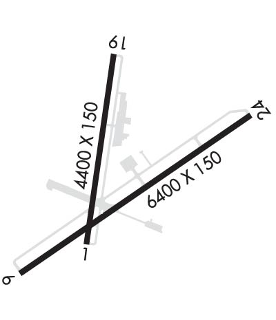
| Lat: N 3544.5 Long: W 08123.4 Elev: 1190 Var: +06 Longest Runway: 6401 | ||
| Clr Del: 121.7 AWOS: 118.32 Ground: 121.7 Tower: 128.15 | ||
| ||||||
| ||||||
|
| Rwy | Rwy | |||||||
| 6401x150 | 6401' | 6401x150 | 6401' | 108.70 - 241° | ||||
| Runway ID | Single Wheel | Double Wheel | Double Tandem Wheel | Dual Double Wheel |
| 06/24 | 120,000 | 198,000 | 321,000 | 766,000 |
| These numbers are Advisory and are not limits. The Airport Manager should have more accurate Weight Limits | ||||
 Airport Diagram might not be current. | |
| Facility Name: | HICKORY RGNL |
| City Name: | HICKORY |
| County: | CATAWBA; AND BURKE COUNTY. |
| State abbrev: | NC |
| State Name: | NORTH CAROLINA |
| Ownership: | PUBLICLY OWNED |
| Use: | OPEN TO THE PUBLIC |
| Owner's Name: | CITY OF HICKORY |
| Address: | PO BOX 398 |
| HICKORY, NC 28603 | |
| Owner's Phone: | 828-327-0147 |
| Manager's Name: | CHAD HUNSUCKER |
| Address: | 3101 9TH AVE DR NW |
| HICKORY, NC 28601 | |
| Phone: | 828-358-8473 |
| FAA Region: | SOUTHERN |
| FAA Field Office: | MEM |
| Date | Sunrise | Sunset |
|---|---|---|
| 06/08/26 Monday | 6:09 | 20:40 |
| 06/09/26 Tuesday | 6:09 | 20:41 |
| 06/10/26 Wednesday | 6:09 | 20:41 |
| 06/11/26 Thursday | 6:09 | 20:41 |
| 06/12/26 Friday | 6:09 | 20:42 |
| 06/13/26 Saturday | 6:09 | 20:42 |
| 06/14/26 Sunday | 6:09 | 20:43 |
| 06/15/26 Monday | 6:09 | 20:43 |
| 06/16/26 Tuesday | 6:09 | 20:43 |
| 06/17/26 Wednesday | 6:09 | 20:44 |
| 06/18/26 Thursday | 6:09 | 20:44 |
| 06/19/26 Friday | 6:09 | 20:44 |
| 06/20/26 Saturday | 6:10 | 20:45 |
| 06/21/26 Sunday | 6:10 | 20:45 |
| Airport Attendance Schedule | MON-FRI 0700-1900, SAT- SUN 0700-1900; SVCS AVAIL M-F 0700-1900 LCL / S & S 0700-1900 LCL. AFT HRS SVCS CALL 828-327-0147. |
| Airport Status | OPERATIONAL (This Status can change at any time - please check NOTAMS) |
| Airport Lighting Schedule | DUSK-DAWN. ACTVT MALSR RWY 24; PAPI RWY 24; HIRL RWY 06/24 - CTAF (2100-0700). PAPI RWY 06 OPR CONSLY. |
| Airport Storage Available | Tie Downs, Hanger |
| Extra Services Available | Air Freight, Charter, Flight Instruction, Aircraft Rental, Aircraft Sales |
| Wind Indicator | YES - (lighted) |
| Control Tower | YES |
| CTAF Frequency | 128.150 |
| Unicom Frequency | |
| Rotating Beacon Color | WG |
| Segmented Circle | YES |
| Landing Fee | NO |
| Airport Inspected | FEDERAL - performed by FAA AIRPORTS FIELD PERSONNEL |
| Inspection Date | 06/25/2025 |
| Type of Fuel Available | Grade 100LL, JET A-1 (icing inhibitor, freeze point -50C); -10100LL AVBL AFT HRS WITH CREDIT CARD. |
| Airframe Repair Service | MAJOR |
| Power Plant Repair Service | MAJOR |
| Latitude | N3544.5 |
| Longitude | W08123.4 (ESTIMATED) |
| Arpt Elevation | 1189ft (SURVEYED) |
| Magnetic Variation | 06W |
| 3 miles W | of HICKORY |
| Traffic Pattern Altitude | |
| Sectional Chart | CHARLOTTE |
| Operations (Reported) | Yearly | Avg. Daily |
|---|---|---|
| General Aviation Transient | 0 | 0 |
| General Aviation Local | 0 | 0 |
| Air Taxi | 0 | 0 |
| Commerical | 0 | 0 |
| Commuter | 0 | 0 |
| Military | 0 | 0 |
| Aircraft based on Field | |
|---|---|
| General Aviation Singles | 0 |
| General Aviation Multi | 0 |
| Jet Aircraft | 0 |
| General Aviation Helicopters | 0 |
| Military Aircraft | 0 |
| Gliders | 0 |
| Ultralights | 0 |
| FSS on field | NO |
| FSS tie-in | RALEIGH |
| FSS Phone | 1-800-WX-BRIEF |
| Who issues Notams | HKY |
| Notam D service at airport | YES |
| ARTCC Name | ATLANTA |
| Airport Certification | AIRPORT RECEIVING SCHEDULED AIR CARRIER SERVICE FROM CARRIERS CERTIFICATED BY THE CIVIL AERONAUTICS BOARD; CLSD TO UNSKED ACR OPNS WITH MORE THAN 30 PSGR SEATS EXCP 24 HR PPR CALL AMGR 828-327-0147. |
| Aircraft Rescue & Firefighting Index | AIRPORT HAS A CERTIFICATE UNDER CFR PART 139 |
| Airport of Entry | No |
| Custom Landing Rights | No |
| Joint Civil/Military | No |
| Military Landing rights | YES |
| NATIONAL PLAN OF INTEGRATED AIRPORT SYSTEMS (NPIAS) |
| GRANT AGREEMENTS UNDER FAAP/ADAP/AIP |
| ASSURANCES PURSUANT TO TITLE VI, CIVIL RIGHTS ACT OF 1964 |
| AFT HRS SVCS CALL 828-327-0147. |
| RWY 06/2 4 PCR VALUE: 550/F/B/X/T |
Airport Communications & Frequencies:
| |||||||||||||
| Runway: 06 | Runway: 24 | ||
| Mag heading: | 61° | Mag heading: | 241° |
| Rwy Slope: | .83% Up | Rwy Slope: | -.83% Down |
| Approach: | Approach: | ILS | |
| Pattern: | Left Traffic | Pattern: | Left Traffic |
| Markings: | NONPRECISION INSTRUMENT | Markings: | PRECISION INSTRUMENT |
| Marking Condition: | FAIR | Marking Condition: | FAIR |
| Arresting Dev: | Arresting Dev: | ||
| Lat & Long: | N3544.1 W08123.8 | Lat. & Long.: | N3544.7 W08122.8 |
| Elev: | 1136.3 ft. MSL | Elev: | 1189.6 ft. MSL |
| TCH: | 57 ft. AGL | TCH: | 54 ft. AGL |
| Visual Glide Path: | 3.00 degrees | Visual Glide Path: | 3.00 degrees |
| Displaced Threshold: | No | Displaced Threshold: | No |
| Touchdown Zone: | YES | Touchdown Zone: | YES |
| Touchdown Elev.: | 1151.9 feet | Touchdown Elev.: | 1189.6 feet |
| Visual Glide Slope: | 4-Light PAPI on LEFT side of Runway | Visual Glide Slope: | 4-Light PAPI on LEFT side of Runway |
| RVR Equipment: | RVR Equipment: | ||
| RVV Equipment: | NO | RVV Equipment: | NO |
| Approach Lights: | Approach Lights: | MALSR - 1,400 foot medium intensity approach lighting system with runway alignment indicator lights | |
| REIL: | YES | REIL: | NO |
| Centerline Lights: | NO | Centerline Lights: | NO |
| Touchdown lights: | NO | Touchdown lights: | NO |
| Runway Category: | Runway with a Non-precision Approach having visibility minimums greater than 3/4 mile | Runway Category: | Precision Instrument Runway |
| Declared Distances: | TORA:6401' TODA:6401' ASDA:6401' LDA:6401' | Declared Distances: | TORA:6401' TODA:6401' ASDA:6401' LDA:6401' |
| Obstructions: | TREES | Obstructions: | |
| Marked: | NOT Marked/Lighted | Marked: | |
| Clearance slope: | 20:1 | Clearance slope: | 50:1 |
| Obstruction height: | 68 feet AGL | Obstruction height: | |
| Dist. from runway: | 1560 feet | Dist. from runway: | |
| Centerline offset: | 300 right of centerline | Centerline offset: | |
| Comments: | Comments: |
Thanks for using FltPlan.com
all rights reserved © 1999-2026 by Flight Plan LLC
