
| HEBRON MUNI HEBRON NE |
| |
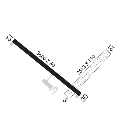
| Lat: N 4009.1 Long: W 09735.1 Elev: 1468 Var: -04 Longest Runway: 3600 | ||
| AWOS: 118.52 CTAF: 122.9 | ||
| ||||||||||||||||||||||||||||||||
| ||||||||||||||||||||||||||||||||
| ||||||||||||||||||||||||||||||||
| Rwy | Rwy | |||||||
| 2513x150 | 2513' | 2513x150 | 2513' | |||||
| 3600x60 | 3600' | 3600x60 | 3600' | |||||
| Runway ID | Single Wheel | Double Wheel | Double Tandem Wheel | Dual Double Wheel |
| 03/21 | N/A | N/A | N/A | N/A |
| 12/30 | 30,000 | N/A | N/A | N/A |
| These numbers are Advisory and are not limits. The Airport Manager should have more accurate Weight Limits | ||||
 Airport Diagram might not be current. | |
| Facility Name: | HEBRON MUNI |
| City Name: | HEBRON |
| County: | THAYER |
| State abbrev: | NE |
| State Name: | NEBRASKA |
| Ownership: | PUBLICLY OWNED |
| Use: | OPEN TO THE PUBLIC |
| Owner's Name: | HEBRON ARPT AUTHORITY |
| Address: | P.O. BOX 256 |
| HEBRON, NE 68370-0256 | |
| Owner's Phone: | (402) 768-6597 |
| Manager's Name: | WILLIAM LINTON |
| Address: | 1115 OLIVE AVE |
| HEBRON, NE 68370-1317 | |
| Phone: | (402) 768-6597 |
| FAA Region: | CENTRAL |
| FAA Field Office: | NONE |

| Date | Sunrise | Sunset |
|---|---|---|
| 09/24/21 Friday | 7:20 | 19:24 |
| 09/25/21 Saturday | 7:21 | 19:23 |
| 09/26/21 Sunday | 7:22 | 19:21 |
| 09/27/21 Monday | 7:23 | 19:19 |
| 09/28/21 Tuesday | 7:23 | 19:18 |
| 09/29/21 Wednesday | 7:24 | 19:16 |
| 09/30/21 Thursday | 7:25 | 19:15 |
| 10/01/21 Friday | 7:26 | 19:13 |
| 10/02/21 Saturday | 7:27 | 19:11 |
| 10/03/21 Sunday | 7:28 | 19:10 |
| 10/04/21 Monday | 7:29 | 19:08 |
| 10/05/21 Tuesday | 7:30 | 19:06 |
| 10/06/21 Wednesday | 7:31 | 19:05 |
| 10/07/21 Thursday | 7:32 | 19:03 |
| Airport Attendance Schedule | UNATTENDED |
| Airport Status | OPERATIONAL (This Status can change at any time - please check NOTAMS) |
| Airport Lighting Schedule | ACTVT MIRL RY 12/30; PAPI & REIL RYS 12 & 30 - CTAF. |
| Airport Storage Available | Tie Downs, Hanger |
| Extra Services Available | Crop Dusting, Flight Instruction |
| Wind Indicator | YES - (lighted) |
| Control Tower | NO |
| CTAF Frequency | 122.900 |
| Unicom Frequency | |
| Rotating Beacon Color | CLEAR-GREEN (Light Land Airport) |
| Segmented Circle | YES |
| Landing Fee | NO |
| Airport Inspected | STATE - performed by STATE AERONAUTICAL PERSONNEL |
| Inspection Date | 05/06/2021 |
| Type of Fuel Available | Grade 100LL, JET A (freeze point -40C); -1024-HR CREDIT CARD READER FOR FUEL. IF UNAVABL CALL (402) 768-6597. |
| Airframe Repair Service | AIRFRAME RPRS BY APNTMT ONLY. |
| Power Plant Repair Service | PWR PLANT RPRS BY APNTMT ONLY. |
| Latitude | N4009.1 |
| Longitude | W09735.1 (ESTIMATED) |
| Arpt Elevation | 1468ft (SURVEYED) |
| Magnetic Variation | 04E |
| 1 miles S | of HEBRON |
| Traffic Pattern Altitude | |
| Sectional Chart | OMAHA |
| Operations (Reported) | Yearly | Avg. Daily |
|---|---|---|
| General Aviation Transient | 540 | 1 |
| General Aviation Local | 4880 | 13 |
| Air Taxi | 0 | 0 |
| Commerical | 0 | 0 |
| Commuter | 0 | 0 |
| Military | 80 | 0 |
| Aircraft based on Field | |
|---|---|
| General Aviation Singles | 8 |
| General Aviation Multi | 1 |
| Jet Aircraft | 0 |
| General Aviation Helicopters | 1 |
| Military Aircraft | 0 |
| Gliders | 0 |
| Ultralights | 0 |
| FSS on field | NO |
| FSS tie-in | COLUMBUS |
| FSS Phone | 1-800-WX-BRIEF |
| Who issues Notams | HJH |
| Notam D service at airport | YES |
| ARTCC Name | MINNEAPOLIS |
| Airport Certification | |
| Aircraft Rescue & Firefighting Index | None |
| Airport of Entry | No |
| Custom Landing Rights | No |
| Joint Civil/Military | No |
| Military Landing rights | No |
| NATIONAL PLAN OF INTEGRATED AIRPORT SYSTEMS (NPIAS) |
| GRANT AGREEMENTS UNDER FAAP/ADAP/AIP |
| ASSURANCES PURSUANT TO TITLE VI, CIVIL RIGHTS ACT OF 1964 |
| THIS AIRPORT HAS BEEN SURVEYED BY THE NATIONAL GEODETIC SURVEY. |
| APCHS PROTECTED BY STRUCTURE CONTROL ORDINANCE. |
| FOR CD CTC MINNEAPOLIS ARTCC AT 651-463-5588. |
Airport Communications & Frequencies:
| |||||||
| Runway: 03 | Runway: 21 | ||
| Mag heading: | 38° | Mag heading: | 218° |
| Rwy Slope: | -.65% Down | Rwy Slope: | .65% Up |
| Approach: | Approach: | ||
| Pattern: | Left Traffic | Pattern: | Left Traffic |
| Markings: | Markings: | ||
| Marking Condition: | RY 03/21 MKD WITH REFLECTORS & YELLOW CONES. | Marking Condition: | |
| Arresting Dev: | Arresting Dev: | ||
| Lat & Long: | N4008.9 W09735.0 | Lat. & Long.: | N4009.2 W09734.7 |
| Elev: | 1468.2 ft. MSL | Elev: | 1451.8 ft. MSL |
| TCH: | TCH: | ||
| Visual Glide Path: | Visual Glide Path: | ||
| Displaced Threshold: | No | Displaced Threshold: | No |
| Touchdown Zone: | YES | Touchdown Zone: | YES |
| Touchdown Elev.: | 1468.2 feet | Touchdown Elev.: | 1468.2 feet |
| Visual Glide Slope: | Visual Glide Slope: | ||
| RVR Equipment: | RVR Equipment: | ||
| RVV Equipment: | NO | RVV Equipment: | NO |
| Approach Lights: | Approach Lights: | ||
| REIL: | NO | REIL: | NO |
| Centerline Lights: | NO | Centerline Lights: | NO |
| Touchdown lights: | NO | Touchdown lights: | NO |
| Runway Category: | Runway with a Visual Approach | Runway Category: | Runway with a Visual Approach |
| Declared Distances: | Declared Distances: | ||
| Obstructions: | TREES | Obstructions: | ROAD |
| Marked: | NOT Marked/Lighted | Marked: | NOT Marked/Lighted |
| Clearance slope: | 20:1 | Clearance slope: | 37:1 |
| Obstruction height: | 54 feet AGL; RWY 21 8 FT TALL CORN IN SUMMER CAN CREATE 22:1. | Obstruction height: | 15 feet AGL |
| Dist. from runway: | 1085 feet | Dist. from runway: | 567 feet |
| Centerline offset: | 222 right of centerline | Centerline offset: | |
| Comments: | Comments: |
| Runway: 12 | Runway: 30 | ||
| Mag heading: | 124° | Mag heading: | 304° |
| Rwy Slope: | .09% Up | Rwy Slope: | -.09% Down |
| Approach: | Approach: | ||
| Pattern: | Left Traffic | Pattern: | Left Traffic |
| Markings: | NONPRECISION INSTRUMENT | Markings: | NONPRECISION INSTRUMENT |
| Marking Condition: | GOOD | Marking Condition: | GOOD |
| Arresting Dev: | Arresting Dev: | ||
| Lat & Long: | N4009.3 W09735.5 | Lat. & Long.: | N4009.0 W09734.9 |
| Elev: | 1462.2 ft. MSL | Elev: | 1465.6 ft. MSL |
| TCH: | 52 ft. AGL | TCH: | 40 ft. AGL |
| Visual Glide Path: | 3.90 degrees | Visual Glide Path: | 3.00 degrees |
| Displaced Threshold: | No | Displaced Threshold: | No |
| Touchdown Zone: | YES | Touchdown Zone: | YES |
| Touchdown Elev.: | 1465.1 feet | Touchdown Elev.: | 1465.6 feet |
| Visual Glide Slope: | 2-Light PAPI on LEFT side of Runway | Visual Glide Slope: | 2-Light PAPI on LEFT side of Runway |
| RVR Equipment: | RVR Equipment: | ||
| RVV Equipment: | NO | RVV Equipment: | NO |
| Approach Lights: | Approach Lights: | ||
| REIL: | YES | REIL: | YES |
| Centerline Lights: | NO | Centerline Lights: | NO |
| Touchdown lights: | NO | Touchdown lights: | NO |
| Runway Category: | Runway with a Non-precision Approach | Runway Category: | Runway with a Non-precision Approach |
| Declared Distances: | Declared Distances: | ||
| Obstructions: | TREE | Obstructions: | ROAD |
| Marked: | NOT Marked/Lighted | Marked: | NOT Marked/Lighted |
| Clearance slope: | 20:1 | Clearance slope: | 20:1 |
| Obstruction height: | 61 feet AGL | Obstruction height: | 27 feet AGL |
| Dist. from runway: | 1428 feet | Dist. from runway: | 743 feet |
| Centerline offset: | 315 right of centerline | Centerline offset: | |
| Comments: | Comments: |
Thanks for using FltPlan.com
all rights reserved © 1999-2021 by Flight Plan LLC