
| PORTLAND-HILLSBORO PORTLAND OR |
| |
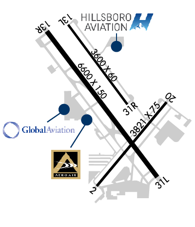
| Lat: N 4532.5 Long: W 12257.0 Elev: 208 Var: -16 Longest Runway: 6600 | ||
| Dept. ATIS: 127.65 Arr. ATIS: 127.65 Ground: 121.7 Tower: 119.3 | ||
| |||||||||||||||||||||||||||||||||||||||||||||||||||||||||||||||||||||
| |||||||||||||||||||||||||||||||||||||||||||||||||||||||||||||||||||||
| |||||||||||||||||||||||||||||||||||||||||||||||||||||||||||||||||||||
| |||||||||||||||||||||||||||||||||||||||||||||||||||||||||||||||||||||
| |||||||||||||||||||||||||||||||||||||||||||||||||||||||||||||||||||||
| Rwy | Rwy | |||||||
| 3820x75 | 3820' | 3820x75 | 3820' | |||||
| 3600x60 | 3600' | 3600x60 | 3600' | |||||
| 6600x150 | 6600' | 110.70 - 127° | 6600x150 | 6600' | ||||
| Runway ID | Single Wheel | Double Wheel | Double Tandem Wheel | Dual Double Wheel |
| 02/20 | 54,500 | 74,000 | 139,000 | N/A |
| 13L/31R | 28,000 | N/A | N/A | N/A |
| 13R/31L | 50,000 | 70,000 | 110,000 | N/A |
| These numbers are Advisory and are not limits. The Airport Manager should have more accurate Weight Limits | ||||
 Airport Diagram might not be current. | |
| Facility Name: | PORTLAND-HILLSBORO |
| City Name: | PORTLAND |
| County: | WASHINGTON |
| State abbrev: | OR |
| State Name: | OREGON |
| Ownership: | PUBLICLY OWNED |
| Use: | OPEN TO THE PUBLIC |
| Owner's Name: | THE PORT OF PORTLAND |
| Address: | BOX 3529 |
| PORTLAND, OR 97208 | |
| Owner's Phone: | 503-944-7000 |
| Manager's Name: | STEPHEN M. NAGY |
| Address: | THE PORT OF PORTLAND, BOX 3529 |
| PORTLAND, OR 97208 | |
| Phone: | 503-460-4119 |
| FAA Region: | NORTHWEST MOUNTAIN |
| FAA Field Office: | SEA |
| Date | Sunrise | Sunset |
|---|---|---|
| 09/24/21 Friday | 7:01 | 19:06 |
| 09/25/21 Saturday | 7:02 | 19:04 |
| 09/26/21 Sunday | 7:04 | 19:02 |
| 09/27/21 Monday | 7:05 | 19:00 |
| 09/28/21 Tuesday | 7:06 | 18:58 |
| 09/29/21 Wednesday | 7:07 | 18:56 |
| 09/30/21 Thursday | 7:09 | 18:54 |
| 10/01/21 Friday | 7:10 | 18:52 |
| 10/02/21 Saturday | 7:11 | 18:50 |
| 10/03/21 Sunday | 7:12 | 18:48 |
| 10/04/21 Monday | 7:14 | 18:47 |
| 10/05/21 Tuesday | 7:15 | 18:45 |
| 10/06/21 Wednesday | 7:16 | 18:43 |
| 10/07/21 Thursday | 7:17 | 18:41 |
| Airport Attendance Schedule | 7 Days A Week 0600-2200 |
| Airport Status | OPERATIONAL (This Status can change at any time - please check NOTAMS) |
| Airport Lighting Schedule | WHEN ATCT CLSD ACTVT MALSR RWY 13R; PAPI RWY 02 & PAPI RWY 20 - CTAF. |
| Airport Storage Available | Tie Downs, Hanger |
| Extra Services Available | Air Freight, Air Ambulance, Avionics, Charter, Flight Instruction, Aircraft Rental, Aircraft Sales |
| Wind Indicator | YES - (lighted) |
| Control Tower | YES |
| CTAF Frequency | 119.300 |
| Unicom Frequency | 122.950 |
| Rotating Beacon Color | CLEAR-GREEN (Light Land Airport) |
| Segmented Circle | NO |
| Landing Fee | YES; COMMERCIAL ACFT & OPERATORS WITH AN FAA CERTIFIED MAX GROSS LANDING WEIGHT THAT EXCEEDS 10000 LBS ARE REQUIRED TO PAY A LANDING FEE. |
| Airport Inspected | STATE - performed by STATE AERONAUTICAL PERSONNEL |
| Inspection Date | 07/13/2020 |
| Type of Fuel Available | Grade 100LL, JET A (freeze point -40C) |
| Airframe Repair Service | MAJOR |
| Power Plant Repair Service | MAJOR |
| Latitude | N4532.5 |
| Longitude | W12257.0 (ESTIMATED) |
| Arpt Elevation | 207ft (SURVEYED) |
| Magnetic Variation | 16E |
| 15 miles SW | of PORTLAND |
| Traffic Pattern Altitude | TPA: 1000 FT AGL, TURBINE AND LARGE AIRCRAFT 1500 FT AGL. |
| Sectional Chart | SEATTLE |
| Operations (Reported) | Yearly | Avg. Daily |
|---|---|---|
| General Aviation Transient | 83381 | 228 |
| General Aviation Local | 160261 | 439 |
| Air Taxi | 9561 | 26 |
| Commerical | 0 | 0 |
| Commuter | 0 | 0 |
| Military | 644 | 2 |
| Aircraft based on Field | |
|---|---|
| General Aviation Singles | 163 |
| General Aviation Multi | 26 |
| Jet Aircraft | 41 |
| General Aviation Helicopters | 23 |
| Military Aircraft | 0 |
| Gliders | 5 |
| Ultralights | 0 |
| FSS on field | NO |
| FSS tie-in | MC MINNVILLE |
| FSS Phone | 1-800-WX-BRIEF |
| Who issues Notams | HIO |
| Notam D service at airport | YES |
| ARTCC Name | SEATTLE |
| Airport Certification | |
| Aircraft Rescue & Firefighting Index | None |
| Airport of Entry | No |
| Custom Landing Rights | YES; US CUSTOMS USER FEE ARPT. |
| Joint Civil/Military | No |
| Military Landing rights | YES |
| NATIONAL PLAN OF INTEGRATED AIRPORT SYSTEMS (NPIAS) |
| GRANT AGREEMENTS UNDER FAAP/ADAP/AIP |
| ASSURANCES PURSUANT TO TITLE VI, CIVIL RIGHTS ACT OF 1964 |
| AGREEMENT UNDER DLAND OR DCLA HAS EXPIRED. |
| BE ALERT FOR BIRD ACTIVITY IN VICINITY NOV-MAY. |
| NIGHTTIME TOUCH AND GOES ARE DISCOURAGED 0600-1400Z++. |
| RWY 2-20 HAS 150' X 75' PAVED BLAST PADS AT BOTH ENDS |
| RWY 13R-31L HAS 200' X 150' PAVED BLAST PADS AT BOTH ENDS |
| GLIDER OPS 5NM NORTHWEST DURING DALGT HOURS MAR-OCT |
| BE ALERT EXTV HELICOPTER TRAINING OPERATIONS TO TWY A, TWY B, TWY D. |
| FOR CD WHEN TWR CLSD CTC PORTLAND APCH AT 503-493-7545. |
| CSTMS AVBL 2000-0400Z++ 503-693-1069, OTHERWISE CSTMS FLT NOTIFICATION SVC (ADCUS) AVBL; ADVANCE COORDINATION REQ 503-326-3230. |
| NOISE ABATEMENT PROCEDURES IN EFFECT CALL 503-460-4100 OR 800-938-6647. |
| RY 13R RUN-UP AREA NOT VISIBLE FROM ATCT. |
| RY 31L IS PREFERRED RY FOR NOISE ABATEMENT. |
| NOISE SENSITIVE AREAS BORDER ARPT WEST, SOUTH AND EAST. |
| FEE-BASED CSTMS FACILITY: $60 SINGLE-ENGINE, $175 TWIN-ENGINE, $500 TURBINE. |
| AVOID LOW-LEVEL OVERFLIGHTS OF RESIDENTIAL AREAS WHENEVER POSSIBLE. |
| RWY 02/2 0 CLSD TO TOUCH AND GO LNDGS BETWEEN 2200-0600. |
Airport Communications & Frequencies:
| |||||||||||||||||||||||||||||||||||
| Runway: 02 | Runway: 20 | ||
| Mag heading: | 23° | Mag heading: | 203° |
| Rwy Slope: | .09% Up | Rwy Slope: | -.09% Down |
| Approach: | Approach: | ||
| Pattern: | Right Traffic | Pattern: | Left Traffic |
| Markings: | BASIC | Markings: | BASIC |
| Marking Condition: | FAIR | Marking Condition: | FAIR |
| Arresting Dev: | Arresting Dev: | ||
| Lat & Long: | N4532.0 W12257.1 | Lat. & Long.: | N4532.5 W12256.5 |
| Elev: | 204.3 ft. MSL | Elev: | 207.9 ft. MSL |
| TCH: | 39 ft. AGL | TCH: | 38 ft. AGL |
| Visual Glide Path: | 3.00 degrees | Visual Glide Path: | 3.00 degrees |
| Displaced Threshold: | No | Displaced Threshold: | No |
| Touchdown Zone: | YES | Touchdown Zone: | YES |
| Touchdown Elev.: | 205.3 feet | Touchdown Elev.: | 207.9 feet |
| Visual Glide Slope: | 4-Light PAPI on RIGHT side of Runway | Visual Glide Slope: | 4-Light PAPI on LEFT side of Runway |
| RVR Equipment: | RVR Equipment: | ||
| RVV Equipment: | NO | RVV Equipment: | NO |
| Approach Lights: | Approach Lights: | ||
| REIL: | NO | REIL: | NO |
| Centerline Lights: | NO | Centerline Lights: | NO |
| Touchdown lights: | NO | Touchdown lights: | NO |
| Runway Category: | Runway Category: | ||
| Declared Distances: | Declared Distances: | ||
| Obstructions: | ROAD | Obstructions: | TREE |
| Marked: | NOT Marked/Lighted | Marked: | NOT Marked/Lighted |
| Clearance slope: | 50:1 | Clearance slope: | 26:1 |
| Obstruction height: | 15 feet AGL | Obstruction height: | 72 feet AGL |
| Dist. from runway: | 1370 feet | Dist. from runway: | 2105 feet |
| Centerline offset: | 270 right of centerline | Centerline offset: | 450 feet left of centerline |
| Comments: | Comments: |
| Runway: 13L | Runway: 31R | ||
| Mag heading: | 128° | Mag heading: | 308° |
| Rwy Slope: | .15% Up | Rwy Slope: | -.15% Down |
| Approach: | Approach: | ||
| Pattern: | Left Traffic | Pattern: | Right Traffic |
| Markings: | BASIC | Markings: | BASIC |
| Marking Condition: | GOOD | Marking Condition: | GOOD |
| Arresting Dev: | Arresting Dev: | ||
| Lat & Long: | N4533.0 W12257.4 | Lat. & Long.: | N4532.5 W12256.9 |
| Elev: | 200.6 ft. MSL | Elev: | 206.1 ft. MSL |
| TCH: | 27 ft. AGL | TCH: | 26 ft. AGL |
| Visual Glide Path: | 3.00 degrees | Visual Glide Path: | 3.00 degrees |
| Displaced Threshold: | No | Displaced Threshold: | No |
| Touchdown Zone: | YES | Touchdown Zone: | YES |
| Touchdown Elev.: | 205.6 feet | Touchdown Elev.: | 206.1 feet |
| Visual Glide Slope: | 4-Light PAPI on LEFT side of Runway; UNUSBL BEYOND 8 DEG L AND R OF RWY CNTRLN | Visual Glide Slope: | 4-Light PAPI on LEFT side of Runway; UNUSBL BEYOND 8 DEG L AND R OF RWY CNTRLN |
| RVR Equipment: | RVR Equipment: | ||
| RVV Equipment: | NO | RVV Equipment: | NO |
| Approach Lights: | Approach Lights: | ||
| REIL: | NO | REIL: | NO |
| Centerline Lights: | NO | Centerline Lights: | NO |
| Touchdown lights: | NO | Touchdown lights: | NO |
| Runway Category: | Runway with a Visual Approach | Runway Category: | Runway with a Visual Approach |
| Declared Distances: | Declared Distances: |
| Runway: 13R | Runway: 31L | ||
| Mag heading: | 127° | Mag heading: | 307° |
| Rwy Slope: | -.03% Down | Rwy Slope: | .03% Up |
| Approach: | ILS | Approach: | |
| Pattern: | Left Traffic | Pattern: | Left Traffic |
| Markings: | PRECISION INSTRUMENT | Markings: | NONPRECISION INSTRUMENT |
| Marking Condition: | GOOD | Marking Condition: | GOOD |
| Arresting Dev: | Arresting Dev: | ||
| Lat & Long: | N4533.0 W12257.6 | Lat. & Long.: | N4532.1 W12256.7 |
| Elev: | 199.9 ft. MSL | Elev: | 198.0 ft. MSL |
| TCH: | 49 ft. AGL | TCH: | 51 ft. AGL |
| Visual Glide Path: | 3.00 degrees | Visual Glide Path: | 3.00 degrees |
| Displaced Threshold: | No | Displaced Threshold: | No |
| Touchdown Zone: | YES | Touchdown Zone: | YES |
| Touchdown Elev.: | 202.8 feet | Touchdown Elev.: | 203.9 feet |
| Visual Glide Slope: | 4-Light PAPI on LEFT side of Runway | Visual Glide Slope: | 4-Light PAPI on LEFT side of Runway |
| RVR Equipment: | TOUCHDOWN | RVR Equipment: | ROLLOUT |
| RVV Equipment: | NO | RVV Equipment: | NO |
| Approach Lights: | MALSR - 1,400 foot medium intensity approach lighting system with runway alignment indicator lights | Approach Lights: | |
| REIL: | NO | REIL: | YES |
| Centerline Lights: | NO | Centerline Lights: | NO |
| Touchdown lights: | NO | Touchdown lights: | NO |
| Runway Category: | Precision Instrument Runway | Runway Category: | Runway with a Non-precision Approach having visibility minimums greater than 3/4 mile |
| Declared Distances: | Declared Distances: | ||
| Obstructions: | Obstructions: | TREE | |
| Marked: | Marked: | NOT Marked/Lighted | |
| Clearance slope: | 50:1 | Clearance slope: | 19:1 |
| Obstruction height: | Obstruction height: | 135 feet AGL | |
| Dist. from runway: | Dist. from runway: | 2800 feet | |
| Centerline offset: | Centerline offset: | 200 feet right of centerline | |
| Comments: | Comments: |
Thanks for using FltPlan.com
all rights reserved © 1999-2021 by Flight Plan LLC