
| RANGE REGIONAL HIBBING MN |
| |
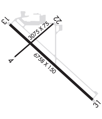
| Lat: N 4723.2 Long: W 09250.3 Elev: 1354 Var: -02 Longest Runway: 6758 | ||
| Clr Del: 127.4 AWOS: 126.42 CTAF: 123.0 | ||
| ||||||||||||||||||||||||||||||||||||||||||||
| ||||||||||||||||||||||||||||||||||||||||||||
| ||||||||||||||||||||||||||||||||||||||||||||
| Rwy | Rwy | |||||||
| 3075x75 | 3075' | 3075x75 | 3075' | |||||
| 6758x150 | 6758' | 110.50 - 130° | 6758x150 | 6758' | 109.50 - 310° | |||
| Runway ID | Single Wheel | Double Wheel | Double Tandem Wheel | Dual Double Wheel |
| 04/22 | 35,000 | 45,000 | N/A | N/A |
| 13/31 | 60,000 | 100,000 | 160,000 | N/A |
| These numbers are Advisory and are not limits. The Airport Manager should have more accurate Weight Limits | ||||
 Airport Diagram might not be current. | |
| Facility Name: | RANGE RGNL |
| City Name: | HIBBING |
| County: | ST LOUIS |
| State abbrev: | MN |
| State Name: | MINNESOTA |
| Ownership: | PUBLICLY OWNED |
| Use: | OPEN TO THE PUBLIC |
| Owner's Name: | CHISHOLM-HIBBING AIRPORT |
| Address: | 11038 HIGHWAY 37 |
| HIBBING, MN 55746-8203 | |
| Owner's Phone: | 218-262-3451 |
| Manager's Name: | BARRETT ZIEMER |
| Address: | 11038 HIGHWAY 37 |
| HIBBING, MN 55746-8203 | |
| Phone: | 218-262-3452 |
| FAA Region: | GREAT LAKES |
| FAA Field Office: | DMA |
| Date | Sunrise | Sunset |
|---|---|---|
| 09/24/21 Friday | 7:00 | 19:05 |
| 09/25/21 Saturday | 7:02 | 19:03 |
| 09/26/21 Sunday | 7:03 | 19:01 |
| 09/27/21 Monday | 7:05 | 18:59 |
| 09/28/21 Tuesday | 7:06 | 18:57 |
| 09/29/21 Wednesday | 7:07 | 18:55 |
| 09/30/21 Thursday | 7:09 | 18:53 |
| 10/01/21 Friday | 7:10 | 18:51 |
| 10/02/21 Saturday | 7:11 | 18:49 |
| 10/03/21 Sunday | 7:13 | 18:47 |
| 10/04/21 Monday | 7:14 | 18:45 |
| 10/05/21 Tuesday | 7:15 | 18:43 |
| 10/06/21 Wednesday | 7:17 | 18:41 |
| 10/07/21 Thursday | 7:18 | 18:39 |
| Airport Attendance Schedule | 7 Days A Week 0400-0000 |
| Airport Status | OPERATIONAL (This Status can change at any time - please check NOTAMS) |
| Airport Lighting Schedule | ACTVT OR INCR INTST MALSR RWY 13 & 31; HIRL RWY 13/31 - CTAF. PAPI RWY 13 & 31 OPR CONSLY; HIRL RWY 13/31 PRESET LOW INTST. |
| Airport Storage Available | Tie Downs |
| Extra Services Available | Air Ambulance, Avionics |
| Wind Indicator | YES - (lighted) |
| Control Tower | NO |
| CTAF Frequency | 123.000 |
| Unicom Frequency | 123.000 |
| Rotating Beacon Color | CLEAR-GREEN (Light Land Airport) |
| Segmented Circle | NO |
| Landing Fee | YES; LDG FEE FOR ALL ACFT OVR 12500 LB. |
| Airport Inspected | FEDERAL - performed by FAA AIRPORTS FIELD PERSONNEL |
| Inspection Date | 09/12/2019 |
| Type of Fuel Available | Grade 100LL, JET A (freeze point -40C) |
| Airframe Repair Service | MAJOR |
| Power Plant Repair Service | MAJOR |
| Latitude | N4723.2 |
| Longitude | W09250.3 (ESTIMATED) |
| Arpt Elevation | 1353ft (SURVEYED) |
| Magnetic Variation | 02E |
| 4 miles SE | of HIBBING |
| Traffic Pattern Altitude | |
| Sectional Chart | GREEN BAY |
| Operations (Reported) | Yearly | Avg. Daily |
|---|---|---|
| General Aviation Transient | 10000 | 27 |
| General Aviation Local | 14000 | 38 |
| Air Taxi | 2225 | 6 |
| Commerical | 2525 | 7 |
| Commuter | 0 | 0 |
| Military | 100 | 0 |
| Aircraft based on Field | |
|---|---|
| General Aviation Singles | 40 |
| General Aviation Multi | 0 |
| Jet Aircraft | 0 |
| General Aviation Helicopters | 1 |
| Military Aircraft | 0 |
| Gliders | 0 |
| Ultralights | 0 |
| FSS on field | NO |
| FSS tie-in | PRINCETON |
| FSS Phone | 1-800-WX-BRIEF |
| Who issues Notams | HIB |
| Notam D service at airport | YES |
| ARTCC Name | MINNEAPOLIS |
| Airport Certification | AIRPORT RECEIVING SCHEDULED AIR CARRIER SERVICE FROM CARRIERS CERTIFICATED BY THE CIVIL AERONAUTICS BOARD; ACR OPS NA IN EXCESS OF 15 MINS BFR OR AFT SKEDD ARR/DEP TIMES WO PRIOR CDN WITH AMGR. 24 HR PPR FOR UNSKED ACR OPS GTR THAN 30 PAX SEATS - CALL AMGR 218-262-3451. |
| Aircraft Rescue & Firefighting Index | AIRPORT HAS A CERTIFICATE UNDER CFR PART 139 |
| Airport of Entry | No |
| Custom Landing Rights | No |
| Joint Civil/Military | No |
| Military Landing rights | YES |
| NATIONAL PLAN OF INTEGRATED AIRPORT SYSTEMS (NPIAS) |
| GRANT AGREEMENTS UNDER FAAP/ADAP/AIP |
| ASSURANCES PURSUANT TO TITLE VI, CIVIL RIGHTS ACT OF 1964 |
| AGREEMENT UNDER DLAND OR DCLA HAS EXPIRED. |
| CTC DULUTH APP CON TO ACTVT RYS 13 & 31 ILS 0600-2300. |
| DIVD ACFT LIMITATIONS - NO INTL PSGR PROCESSING. ONLY ONE ACR GATE. LTD STERILE AREA SPACE (125 PSGRS). VENDING CONCESSIONS ONLY. |
| FOR CD CTC DULUTH APCH AT 218-740-5950. |
| TWY A AND TWY B AT THE APCH END OF RWY 22 CLSD TO ACR OPS DURG THE HRS OF DARKNESS AND CONDS BLW VFR MNMS AIRFIELD. GUIDANCE SIGNS UNLIT. |
| BIRDS ON & INVOF ARPT. |
| FLD CONDS UNMON 0000-0400. |
| RWY 04/2 2 CLSD TO SKEDD ACR OPS GTR THAN 9 PAX SEATS OR UNSKED ACR OPS GTR THAN 30 PAX SEATS. CLSD AT NGT. |
Airport Communications & Frequencies:
| ||||||||||||||||
| Runway: 04 | Runway: 22 | ||
| Mag heading: | 47° | Mag heading: | 227° |
| Rwy Slope: | .10% Up | Rwy Slope: | -.10% Down |
| Approach: | Approach: | ||
| Pattern: | Left Traffic | Pattern: | Left Traffic |
| Markings: | NONPRECISION INSTRUMENT | Markings: | BASIC |
| Marking Condition: | GOOD | Marking Condition: | GOOD |
| Arresting Dev: | Arresting Dev: | ||
| Lat & Long: | N4723.2 W09250.8 | Lat. & Long.: | N4723.5 W09250.2 |
| Elev: | 1349.0 ft. MSL | Elev: | 1352.0 ft. MSL |
| TCH: | TCH: | ||
| Visual Glide Path: | Visual Glide Path: | ||
| Displaced Threshold: | No | Displaced Threshold: | No |
| Touchdown Zone: | YES | Touchdown Zone: | YES |
| Touchdown Elev.: | 1351.8 feet | Touchdown Elev.: | 1352.0 feet |
| Visual Glide Slope: | Visual Glide Slope: | ||
| RVR Equipment: | RVR Equipment: | ||
| RVV Equipment: | NO | RVV Equipment: | NO |
| Approach Lights: | Approach Lights: | ||
| REIL: | NO | REIL: | NO |
| Centerline Lights: | NO | Centerline Lights: | NO |
| Touchdown lights: | NO | Touchdown lights: | NO |
| Runway Category: | Runway with a Non-precision Approach | Runway Category: | Runway with a Non-precision Approach |
| Declared Distances: | TORA:3075' TODA:3075' ASDA:3075' LDA:3075' | Declared Distances: | TORA:3075' TODA:3075' ASDA:3075' LDA:3075' |
| Obstructions: | ROAD | Obstructions: | ROAD |
| Marked: | NOT Marked/Lighted | Marked: | NOT Marked/Lighted |
| Clearance slope: | 11:1 | Clearance slope: | 42:1 |
| Obstruction height: | 10 feet AGL | Obstruction height: | 17 feet AGL |
| Dist. from runway: | 310 feet | Dist. from runway: | 930 feet |
| Centerline offset: | 250 right of centerline | Centerline offset: | 350 feet right of centerline |
| Comments: | Comments: |
| Runway: 13 | Runway: 31 | ||
| Mag heading: | 130° | Mag heading: | 310° |
| Rwy Slope: | -.23% Down | Rwy Slope: | .23% Up |
| Approach: | ILS | Approach: | ILS |
| Pattern: | Left Traffic | Pattern: | Left Traffic |
| Markings: | PRECISION INSTRUMENT | Markings: | PRECISION INSTRUMENT |
| Marking Condition: | GOOD | Marking Condition: | GOOD |
| Arresting Dev: | Arresting Dev: | ||
| Lat & Long: | N4723.5 W09250.9 | Lat. & Long.: | N4722.8 W09249.7 |
| Elev: | 1353.7 ft. MSL | Elev: | 1338.2 ft. MSL |
| TCH: | 50 ft. AGL | TCH: | 62 ft. AGL |
| Visual Glide Path: | 3.00 degrees | Visual Glide Path: | 2.90 degrees |
| Displaced Threshold: | No | Displaced Threshold: | No |
| Touchdown Zone: | YES | Touchdown Zone: | YES |
| Touchdown Elev.: | 1353.7 feet | Touchdown Elev.: | 1344.8 feet |
| Visual Glide Slope: | 4-Light PAPI on LEFT side of Runway | Visual Glide Slope: | 4-Light PAPI on LEFT side of Runway |
| RVR Equipment: | RVR Equipment: | ||
| RVV Equipment: | NO | RVV Equipment: | NO |
| Approach Lights: | MALSR - 1,400 foot medium intensity approach lighting system with runway alignment indicator lights | Approach Lights: | MALSR - 1,400 foot medium intensity approach lighting system with runway alignment indicator lights |
| REIL: | NO | REIL: | NO |
| Centerline Lights: | NO | Centerline Lights: | NO |
| Touchdown lights: | NO | Touchdown lights: | NO |
| Runway Category: | Precision Instrument Runway | Runway Category: | Precision Instrument Runway |
| Declared Distances: | TORA:6758' TODA:6758' ASDA:6758' LDA:6758' | Declared Distances: | TORA:6758' TODA:6758' ASDA:6758' LDA:6758' |
Thanks for using FltPlan.com
all rights reserved © 1999-2021 by Flight Plan LLC
