
| HUNTINGTON MUNI HUNTINGTON IN |
| |
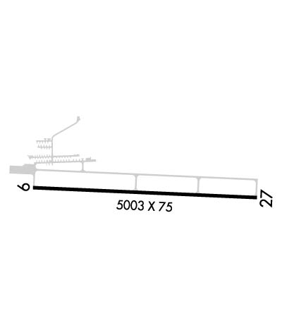
| Lat: N 4051.2 Long: W 08527.4 Elev: 806 Var: +03 Longest Runway: 5003 | ||
| AWOS: 126.57 CTAF: 122.8 | ||
| |||||||||||||||||||||||||||||||||||||||||||||||||||||||||||||
| |||||||||||||||||||||||||||||||||||||||||||||||||||||||||||||
| |||||||||||||||||||||||||||||||||||||||||||||||||||||||||||||
| Rwy | Rwy | |||||||
| 5003x75 | 5003' | 5003x75 | 5003' | |||||
| Runway ID | Single Wheel | Double Wheel | Double Tandem Wheel | Dual Double Wheel |
| 09/27 | 38,000 | 50,000 | N/A | N/A |
| These numbers are Advisory and are not limits. The Airport Manager should have more accurate Weight Limits | ||||
 Airport Diagram might not be current. | |
| Facility Name: | HUNTINGTON MUNI |
| City Name: | HUNTINGTON |
| County: | HUNTINGTON |
| State abbrev: | IN |
| State Name: | INDIANA |
| Ownership: | PUBLICLY OWNED |
| Use: | OPEN TO THE PUBLIC |
| Owner's Name: | HUNTINGTON BOAC |
| Address: | 1365 WARREN RD |
| HUNTINGTON, IN 46750 | |
| Owner's Phone: | 260-356-8515 |
| Manager's Name: | SCOTT NICOLA |
| Address: | 1365 WARREN RD |
| HUNTINGTON, IN 46750 | |
| Phone: | 260-356-8515 |
| FAA Region: | GREAT LAKES |
| FAA Field Office: | CHI |
| Date | Sunrise | Sunset |
|---|---|---|
| 09/24/21 Friday | 7:31 | 19:36 |
| 09/25/21 Saturday | 7:32 | 19:34 |
| 09/26/21 Sunday | 7:33 | 19:33 |
| 09/27/21 Monday | 7:34 | 19:31 |
| 09/28/21 Tuesday | 7:35 | 19:29 |
| 09/29/21 Wednesday | 7:36 | 19:28 |
| 09/30/21 Thursday | 7:37 | 19:26 |
| 10/01/21 Friday | 7:38 | 19:24 |
| 10/02/21 Saturday | 7:39 | 19:23 |
| 10/03/21 Sunday | 7:40 | 19:21 |
| 10/04/21 Monday | 7:41 | 19:19 |
| 10/05/21 Tuesday | 7:42 | 19:18 |
| 10/06/21 Wednesday | 7:43 | 19:16 |
| 10/07/21 Thursday | 7:44 | 19:14 |
| Airport Attendance Schedule | MON - SAT 0800-1700, SUN 1200-1700; ARPT UNATNDD HOLIDAYS. |
| Airport Status | OPERATIONAL (This Status can change at any time - please check NOTAMS) |
| Airport Lighting Schedule | MIRL RY 09/27 PRESET ON LOW INTST; TO INCR INTST & ACTVT REIL RYS 09 & 27 - CTAF. |
| Airport Storage Available | Tie Downs, Hanger |
| Extra Services Available | Flight Instruction, Aircraft Rental, Aircraft Sales |
| Wind Indicator | YES - (lighted) |
| Control Tower | NO |
| CTAF Frequency | 122.800 |
| Unicom Frequency | 122.800 |
| Rotating Beacon Color | CLEAR-GREEN (Light Land Airport) |
| Segmented Circle | NO |
| Landing Fee | NO |
| Airport Inspected | STATE - performed by STATE AERONAUTICAL PERSONNEL |
| Inspection Date | 09/18/2018 |
| Type of Fuel Available | Grade 100LL, JET A (freeze point -40C); -10SELF SVC AVBL. |
| Airframe Repair Service | MAJOR |
| Power Plant Repair Service | MAJOR |
| Latitude | N4051.2 |
| Longitude | W08527.4 (ESTIMATED) |
| Arpt Elevation | 805ft (SURVEYED) |
| Magnetic Variation | 03W |
| 3 miles SE | of HUNTINGTON |
| Traffic Pattern Altitude | |
| Sectional Chart | CHICAGO |
| Operations (Reported) | Yearly | Avg. Daily |
|---|---|---|
| General Aviation Transient | 1667 | 5 |
| General Aviation Local | 3492 | 10 |
| Air Taxi | 52 | 0 |
| Commerical | 0 | 0 |
| Commuter | 0 | 0 |
| Military | 0 | 0 |
| Aircraft based on Field | |
|---|---|
| General Aviation Singles | 40 |
| General Aviation Multi | 1 |
| Jet Aircraft | 1 |
| General Aviation Helicopters | 0 |
| Military Aircraft | 0 |
| Gliders | 0 |
| Ultralights | 0 |
| FSS on field | NO |
| FSS tie-in | TERRE HAUTE |
| FSS Phone | 1-800-WX-BRIEF |
| Who issues Notams | HUF |
| Notam D service at airport | YES |
| ARTCC Name | CHICAGO |
| Airport Certification | |
| Aircraft Rescue & Firefighting Index | None |
| Airport of Entry | No |
| Custom Landing Rights | No |
| Joint Civil/Military | No |
| Military Landing rights | YES |
| NATIONAL PLAN OF INTEGRATED AIRPORT SYSTEMS (NPIAS) |
| GRANT AGREEMENTS UNDER FAAP/ADAP/AIP |
| ASSURANCES PURSUANT TO TITLE VI, CIVIL RIGHTS ACT OF 1964 |
| THIS AIRPORT HAS BEEN SURVEYED BY THE NATIONAL GEODETIC SURVEY. |
| DEER ON & INVOF ARPT, ESPECIALLY EARLY MRNG & EVNG HRS. |
| 24-HR INSIDE PHONE AVBL. |
| FOR CD CTC CHICAGO ARTCC AT 630-906-8921. |
Airport Communications & Frequencies:
| ||||||||||||||
| Runway: 09 | Runway: 27 | ||
| Mag heading: | 95° | Mag heading: | 275° |
| Rwy Slope: | -.01% Down | Rwy Slope: | .01% Up |
| Approach: | Approach: | ||
| Pattern: | Left Traffic | Pattern: | Left Traffic |
| Markings: | NONPRECISION INSTRUMENT | Markings: | NONPRECISION INSTRUMENT |
| Marking Condition: | FAIR | Marking Condition: | FAIR |
| Arresting Dev: | Arresting Dev: | ||
| Lat & Long: | N4051.2 W08528.0 | Lat. & Long.: | N4051.2 W08526.9 |
| Elev: | 804.8 ft. MSL | Elev: | 804.2 ft. MSL |
| TCH: | 39 ft. AGL | TCH: | 49 ft. AGL |
| Visual Glide Path: | 3.00 degrees | Visual Glide Path: | 3.00 degrees |
| Displaced Threshold: | No | Displaced Threshold: | No |
| Touchdown Zone: | YES | Touchdown Zone: | YES |
| Touchdown Elev.: | 805.6 feet | Touchdown Elev.: | 805.7 feet |
| Visual Glide Slope: | 2-Light PAPI on LEFT side of Runway | Visual Glide Slope: | 2-Light PAPI on LEFT side of Runway |
| RVR Equipment: | RVR Equipment: | ||
| RVV Equipment: | NO | RVV Equipment: | NO |
| Approach Lights: | Approach Lights: | ||
| REIL: | YES | REIL: | YES |
| Centerline Lights: | NO | Centerline Lights: | NO |
| Touchdown lights: | NO | Touchdown lights: | NO |
| Runway Category: | Runway with a Non-precision Approach | Runway Category: | Runway with a Non-precision Approach |
| Declared Distances: | Declared Distances: | ||
| Obstructions: | TREES | Obstructions: | TREES |
| Marked: | NOT Marked/Lighted | Marked: | NOT Marked/Lighted |
| Clearance slope: | 8:1 | Clearance slope: | 13:1 |
| Obstruction height: | 55 feet AGL | Obstruction height: | 65 feet AGL |
| Dist. from runway: | 675 feet | Dist. from runway: | 1100 feet |
| Centerline offset: | Centerline offset: | ||
| Comments: | Comments: |
Thanks for using FltPlan.com
all rights reserved © 1999-2021 by Flight Plan LLC

