
| HETTINGER MUNI HETTINGER ND |
| |
| Lat: N 4600.9 Long: W 10239.4 Elev: 2706 Var: -08 Longest Runway: 4652 | ||
| AWOS: 119.92 CTAF: 122.8 | ||
| ||||||||||||||||||||||||||||||||||||||||||||
| ||||||||||||||||||||||||||||||||||||||||||||
| ||||||||||||||||||||||||||||||||||||||||||||
| Rwy | Rwy | |||||||
| 4652x75 | 4652' | 4652x75 | 4652' | |||||
| 2020x110 | 2020' | 2020x110 | 2020' | |||||
| Runway ID | Single Wheel | Double Wheel | Double Tandem Wheel | Dual Double Wheel |
| 12/30 | 11,500 | N/A | N/A | N/A |
| 17/35 | N/A | N/A | N/A | N/A |
| These numbers are Advisory and are not limits. The Airport Manager should have more accurate Weight Limits | ||||
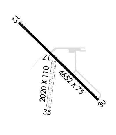 Airport Diagram might not be current. | |
| Facility Name: | HETTINGER/JB LINDQUIST RGNL |
| City Name: | HETTINGER |
| County: | ADAMS |
| State abbrev: | ND |
| State Name: | NORTH DAKOTA |
| Ownership: | PUBLICLY OWNED |
| Use: | OPEN TO THE PUBLIC |
| Owner's Name: | ADAMS CO ARPT AUTH |
| Address: | BOX 429 |
| HETTINGER, ND 58639 | |
| Owner's Phone: | 701-567-2069 |
| Manager's Name: | JAY B. LINDQUIST |
| Address: | PO BOX 429 |
| HETTINGER, ND 58639 | |
| Phone: | 701-567-2069; ADDL CTC AFT HRS CHARLES LINDQUIST 701-567-4469 OR 701-928-0615. |
| FAA Region: | GREAT LAKES |
| FAA Field Office: | DMA |
| Date | Sunrise | Sunset |
|---|---|---|
| 06/08/26 Monday | 5:00 | 20:39 |
| 06/09/26 Tuesday | 5:00 | 20:40 |
| 06/10/26 Wednesday | 5:00 | 20:41 |
| 06/11/26 Thursday | 5:00 | 20:41 |
| 06/12/26 Friday | 4:59 | 20:42 |
| 06/13/26 Saturday | 4:59 | 20:42 |
| 06/14/26 Sunday | 4:59 | 20:43 |
| 06/15/26 Monday | 4:59 | 20:43 |
| 06/16/26 Tuesday | 4:59 | 20:44 |
| 06/17/26 Wednesday | 4:59 | 20:44 |
| 06/18/26 Thursday | 4:59 | 20:44 |
| 06/19/26 Friday | 4:59 | 20:45 |
| 06/20/26 Saturday | 4:59 | 20:45 |
| 06/21/26 Sunday | 5:00 | 20:45 |
| Airport Attendance Schedule | MON-SAT 0700-1700; FOR ATTENDANT DUSK-DAWN CALL (701) 928-0615. |
| Airport Status | OPERATIONAL (This Status can change at any time - please check NOTAMS) |
| Airport Lighting Schedule | PAPI RWY 12 & 30; MIRL RWY 12/30 OPR CONSLY FM DUSK TO 2200; AFT 2200 TO ACTVT PAPI RWY 12 & 30; MIRL RWY 12/30 - CTAF. |
| Airport Storage Available | Tie Downs, Hanger |
| Extra Services Available | Crop Dusting, Flight Instruction, Aircraft Rental, Aircraft Sales |
| Wind Indicator | YES - (lighted) |
| Control Tower | NO |
| CTAF Frequency | 122.800 |
| Unicom Frequency | 122.800 |
| Rotating Beacon Color | WG |
| Segmented Circle | YES |
| Landing Fee | NO |
| Airport Inspected | STATE - performed by STATE AERONAUTICAL PERSONNEL |
| Inspection Date | 06/19/2024 |
| Type of Fuel Available | Grade 100LL, JET A (freeze point -40C); -1024-HR SELF- SERVICE FUEL AVBL WITH CREDIT CARD. |
| Airframe Repair Service | MAJOR |
| Power Plant Repair Service | MAJOR |
| Latitude | N4600.9 |
| Longitude | W10239.4 (ESTIMATED) |
| Arpt Elevation | 2705ft (SURVEYED) |
| Magnetic Variation | 08E |
| 1 miles NW | of HETTINGER |
| Traffic Pattern Altitude | |
| Sectional Chart | BILLINGS |
| Operations (Reported) | Yearly | Avg. Daily |
|---|---|---|
| General Aviation Transient | 0 | 0 |
| General Aviation Local | 0 | 0 |
| Air Taxi | 0 | 0 |
| Commerical | 0 | 0 |
| Commuter | 0 | 0 |
| Military | 0 | 0 |
| Aircraft based on Field | |
|---|---|
| General Aviation Singles | 0 |
| General Aviation Multi | 0 |
| Jet Aircraft | 0 |
| General Aviation Helicopters | 0 |
| Military Aircraft | 0 |
| Gliders | 0 |
| Ultralights | 0 |
| FSS on field | NO |
| FSS tie-in | GRAND FORKS |
| FSS Phone | 1-800-WX-BRIEF |
| Who issues Notams | HEI |
| Notam D service at airport | YES |
| ARTCC Name | MINNEAPOLIS |
| Airport Certification | |
| Aircraft Rescue & Firefighting Index | None |
| Airport of Entry | No |
| Custom Landing Rights | No |
| Joint Civil/Military | No |
| Military Landing rights | YES |
| NATIONAL PLAN OF INTEGRATED AIRPORT SYSTEMS (NPIAS) |
| GRANT AGREEMENTS UNDER FAAP/ADAP/AIP |
| ASSURANCES PURSUANT TO TITLE VI, CIVIL RIGHTS ACT OF 1964 |
| CFM WINTER COND RWY 17/35 CALL AMGR 701-567-2069/4469 OR 701-928-0615. |
| TWYS ILLUMINATED WITH REFLECTORS FOR NIGHTIME USE. |
| DEER ON & INVOF ARPT. |
| FOR CD CTC MINNEAPOLIS ARTCC AT 651-463-5588. |
| WIND TURBINES LCTD APRXLY 13000 FT NE OF ARPT. |
Airport Communications & Frequencies:
| |||||||||
| Runway: 12 | Runway: 30 | ||
| Mag heading: | 128° | Mag heading: | 308° |
| Rwy Slope: | -.14% Down | Rwy Slope: | .14% Up |
| Approach: | Approach: | ||
| Pattern: | Left Traffic | Pattern: | Left Traffic |
| Markings: | NONPRECISION INSTRUMENT | Markings: | NONPRECISION INSTRUMENT |
| Marking Condition: | GOOD | Marking Condition: | GOOD |
| Arresting Dev: | Arresting Dev: | ||
| Lat & Long: | N4601.2 W10239.7 | Lat. & Long.: | N4600.7 W10239.0 |
| Elev: | 2705.3 ft. MSL | Elev: | 2698.9 ft. MSL |
| TCH: | 25 ft. AGL | TCH: | 25 ft. AGL |
| Visual Glide Path: | 3.00 degrees | Visual Glide Path: | 3.00 degrees |
| Displaced Threshold: | No | Displaced Threshold: | No |
| Touchdown Zone: | YES | Touchdown Zone: | YES |
| Touchdown Elev.: | 2705.6 feet | Touchdown Elev.: | 2705.8 feet |
| Visual Glide Slope: | 2-Light PAPI on LEFT side of Runway | Visual Glide Slope: | 2-Light PAPI on LEFT side of Runway |
| RVR Equipment: | RVR Equipment: | ||
| RVV Equipment: | NO | RVV Equipment: | NO |
| Approach Lights: | Approach Lights: | ||
| REIL: | NO | REIL: | NO |
| Centerline Lights: | NO | Centerline Lights: | NO |
| Touchdown lights: | NO | Touchdown lights: | NO |
| Runway Category: | Runway with a Non-precision Approach | Runway Category: | Runway with a Non-precision Approach |
| Declared Distances: | Declared Distances: |
| Runway: 17 | Runway: 35 | ||
| Mag heading: | 182° | Mag heading: | 2° |
| Rwy Slope: | -.73% Down | Rwy Slope: | .73% Up |
| Approach: | Approach: | ||
| Pattern: | Left Traffic | Pattern: | Left Traffic |
| Markings: | Markings: | ||
| Marking Condition: | Marking Condition: | ||
| Arresting Dev: | Arresting Dev: | ||
| Lat & Long: | N4600.9 W10239.4 | Lat. & Long.: | N4600.6 W10239.5 |
| Elev: | 2702.4 ft. MSL | Elev: | 2687.6 ft. MSL |
| TCH: | TCH: | ||
| Visual Glide Path: | Visual Glide Path: | ||
| Displaced Threshold: | No | Displaced Threshold: | No |
| Touchdown Zone: | YES | Touchdown Zone: | YES |
| Touchdown Elev.: | 2702.4 feet | Touchdown Elev.: | 2702.4 feet |
| Visual Glide Slope: | Visual Glide Slope: | ||
| RVR Equipment: | RVR Equipment: | ||
| RVV Equipment: | NO | RVV Equipment: | NO |
| Approach Lights: | Approach Lights: | ||
| REIL: | NO | REIL: | NO |
| Centerline Lights: | NO | Centerline Lights: | NO |
| Touchdown lights: | NO | Touchdown lights: | NO |
| Runway Category: | Runway with a Visual Approach | Runway Category: | Runway with a Visual Approach |
| Declared Distances: | Declared Distances: |
Thanks for using FltPlan.com
all rights reserved © 1999-2026 by Flight Plan LLC
