
| HERLONG JACKSONVILLE FL |
| |
| Lat: N 3016.7 Long: W 08148.4 Elev: 86 Var: +06 Longest Runway: 4001 | ||
| Clr Del: 121.72 GCO AWOS: 119.27 CTAF: 123.0 | ||
| ||||||||||||||||||||||||||||||||||||||||||||
| ||||||||||||||||||||||||||||||||||||||||||||
| ||||||||||||||||||||||||||||||||||||||||||||
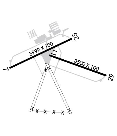
| Rwy | Rwy | |||||||
| 4001x100 | 4001' | 4001x100 | 4001' | |||||
| 3500x100 | 3500' | 3500x100 | 3500' | |||||
| Runway ID | Single Wheel | Double Wheel | Double Tandem Wheel | Dual Double Wheel |
| 07/25 | 30,000 | N/A | N/A | N/A |
| 11/29 | 30,000 | N/A | N/A | N/A |
| These numbers are Advisory and are not limits. The Airport Manager should have more accurate Weight Limits | ||||
 Airport Diagram might not be current. | |
| Facility Name: | HERLONG RECREATIONAL |
| City Name: | JACKSONVILLE |
| County: | DUVAL |
| State abbrev: | FL |
| State Name: | FLORIDA |
| Ownership: | PUBLICLY OWNED |
| Use: | OPEN TO THE PUBLIC |
| Owner's Name: | JACKSONVILLE AVIATION AUTHORITY; 904-741-2040. |
| Address: | 14201 PECAN PARK ROAD |
| JACKSONVILLE, FL 32218 | |
| Owner's Phone: | 904-741-2069 |
| Manager's Name: | ROLF RIECHMANN |
| Address: | 9300 NORMANDY BLVD., SUITE 4 |
| JACKSONVILLE, FL 32221-5522 | |
| Phone: | 904-783-2805; FBO (904) 783-2805. |
| FAA Region: | SOUTHERN |
| FAA Field Office: | ORL |
| Date | Sunrise | Sunset |
|---|---|---|
| 06/08/26 Monday | 6:25 | 20:28 |
| 06/09/26 Tuesday | 6:25 | 20:28 |
| 06/10/26 Wednesday | 6:25 | 20:29 |
| 06/11/26 Thursday | 6:25 | 20:29 |
| 06/12/26 Friday | 6:25 | 20:29 |
| 06/13/26 Saturday | 6:25 | 20:30 |
| 06/14/26 Sunday | 6:25 | 20:30 |
| 06/15/26 Monday | 6:25 | 20:30 |
| 06/16/26 Tuesday | 6:25 | 20:31 |
| 06/17/26 Wednesday | 6:25 | 20:31 |
| 06/18/26 Thursday | 6:25 | 20:31 |
| 06/19/26 Friday | 6:25 | 20:32 |
| 06/20/26 Saturday | 6:26 | 20:32 |
| 06/21/26 Sunday | 6:26 | 20:32 |
| Airport Attendance Schedule | MON-FRI 0630-1930, SAT-SUN 0700-1700 |
| Airport Status | OPERATIONAL (This Status can change at any time - please check NOTAMS) |
| Airport Lighting Schedule | ACTVT MIRL RWY 07/25 & 11/29 - CTAF. |
| Airport Storage Available | Tie Downs, Hanger |
| Extra Services Available | Avionics, Charter, Glider, Flight Instruction, Parachute Jumping, Aircraft Rental, Aircraft Sales, Glider Towing |
| Wind Indicator | YES - (lighted) |
| Control Tower | NO |
| CTAF Frequency | 123.000 |
| Unicom Frequency | 123.000 |
| Rotating Beacon Color | WG |
| Segmented Circle | Y-L |
| Landing Fee | NO |
| Airport Inspected | STATE - performed by STATE AERONAUTICAL PERSONNEL |
| Inspection Date | 02/11/2026 |
| Type of Fuel Available | Grade 100LL, JET A (freeze point -40C) |
| Airframe Repair Service | MAJOR |
| Power Plant Repair Service | MAJOR |
| Latitude | N3016.7 |
| Longitude | W08148.4 (ESTIMATED) |
| Arpt Elevation | 85ft (SURVEYED) |
| Magnetic Variation | 06W |
| 8 miles SW | of JACKSONVILLE |
| Traffic Pattern Altitude | |
| Sectional Chart | JACKSONVILLE |
| Operations (Reported) | Yearly | Avg. Daily |
|---|---|---|
| General Aviation Transient | 0 | 0 |
| General Aviation Local | 0 | 0 |
| Air Taxi | 0 | 0 |
| Commerical | 0 | 0 |
| Commuter | 0 | 0 |
| Military | 0 | 0 |
| Aircraft based on Field | |
|---|---|
| General Aviation Singles | 0 |
| General Aviation Multi | 0 |
| Jet Aircraft | 0 |
| General Aviation Helicopters | 0 |
| Military Aircraft | 0 |
| Gliders | 0 |
| Ultralights | 0 |
| FSS on field | NO |
| FSS tie-in | GAINESVILLE |
| FSS Phone | 1-800-WX-BRIEF |
| Who issues Notams | GNV |
| Notam D service at airport | YES |
| ARTCC Name | JACKSONVILLE |
| Airport Certification | |
| Aircraft Rescue & Firefighting Index | None |
| Airport of Entry | No |
| Custom Landing Rights | No |
| Joint Civil/Military | No |
| Military Landing rights | YES |
| NATIONAL PLAN OF INTEGRATED AIRPORT SYSTEMS (NPIAS) |
| GRANT AGREEMENTS UNDER FAAP/ADAP/AIP |
| SURPLUS PROPERTY AGREEMENT UNDER REGULATION 16-WAA |
| ASSURANCES PURSUANT TO TITLE VI, CIVIL RIGHTS ACT OF 1964 |
| ULTRALIGHT & GLIDER ACTIVITY ON & INVOF ARPT. |
| GCO AVBL ON FREQ 121.725 THRU JACKSONVILLE ARTCC CD AND GAINESVILLE FSS. |
| FOR CD IF UNA VIA GCO CTC JACKSONVILLE ARTCC AT 904-741-0284. |
| 24-HOUR PPR FOR ACFT EQUIPPED WITH WEATHER MODIFICATION OR GEOENGINEERING EQPT 904-741-2020. |
Airport Communications & Frequencies:
| ||||||||||||||
| Runway: 07 | Runway: 25 | ||
| Mag heading: | 71° | Mag heading: | 251° |
| Rwy Slope: | .16% Up | Rwy Slope: | -.16% Down |
| Approach: | Approach: | ||
| Pattern: | Left Traffic | Pattern: | Left Traffic |
| Markings: | BASIC | Markings: | NONPRECISION INSTRUMENT |
| Marking Condition: | GOOD | Marking Condition: | GOOD |
| Arresting Dev: | Arresting Dev: | ||
| Lat & Long: | N3016.6 W08148.9 | Lat. & Long.: | N3016.9 W08148.2 |
| Elev: | 73.4 ft. MSL | Elev: | 79.9 ft. MSL |
| TCH: | 40 ft. AGL | TCH: | 40 ft. AGL |
| Visual Glide Path: | 3.00 degrees | Visual Glide Path: | 3.00 degrees |
| Displaced Threshold: | No | Displaced Threshold: | No |
| Touchdown Zone: | YES | Touchdown Zone: | YES |
| Touchdown Elev.: | 85.9 feet | Touchdown Elev.: | 85.9 feet |
| Visual Glide Slope: | 2-Light PAPI on LEFT side of Runway | Visual Glide Slope: | 2-Light PAPI on LEFT side of Runway |
| RVR Equipment: | RVR Equipment: | ||
| RVV Equipment: | NO | RVV Equipment: | NO |
| Approach Lights: | Approach Lights: | ||
| REIL: | NO | REIL: | NO |
| Centerline Lights: | NO | Centerline Lights: | NO |
| Touchdown lights: | NO | Touchdown lights: | NO |
| Runway Category: | Runway with a Visual Approach | Runway Category: | Runway with a Non-precision Approach having visibility minimums greater than 3/4 mile |
| Declared Distances: | Declared Distances: | ||
| Obstructions: | TREE | Obstructions: | TREES |
| Marked: | NOT Marked/Lighted | Marked: | NOT Marked/Lighted |
| Clearance slope: | 24:1 | Clearance slope: | 34:1 |
| Obstruction height: | 50 feet AGL | Obstruction height: | 60 feet AGL |
| Dist. from runway: | 1395 feet | Dist. from runway: | 2215 feet |
| Centerline offset: | 210 right of centerline | Centerline offset: | 50 feet right of centerline |
| Comments: | Comments: |
| Runway: 11 | Runway: 29 | ||
| Mag heading: | 116° | Mag heading: | 296° |
| Rwy Slope: | -.05% Down | Rwy Slope: | .05% Up |
| Approach: | Approach: | ||
| Pattern: | Left Traffic | Pattern: | Left Traffic |
| Markings: | BASIC | Markings: | BASIC |
| Marking Condition: | GOOD | Marking Condition: | GOOD |
| Arresting Dev: | Arresting Dev: | ||
| Lat & Long: | N3016.7 W08148.4 | Lat. & Long.: | N3016.5 W08147.8 |
| Elev: | 84.6 ft. MSL | Elev: | 82.7 ft. MSL |
| TCH: | 40 ft. AGL | TCH: | 40 ft. AGL |
| Visual Glide Path: | 3.00 degrees | Visual Glide Path: | 3.00 degrees |
| Displaced Threshold: | No | Displaced Threshold: | No |
| Touchdown Zone: | YES | Touchdown Zone: | YES |
| Touchdown Elev.: | 84.6 feet | Touchdown Elev.: | 83.1 feet |
| Visual Glide Slope: | 2-Light PAPI on LEFT side of Runway | Visual Glide Slope: | 2-Light PAPI on LEFT side of Runway |
| RVR Equipment: | RVR Equipment: | ||
| RVV Equipment: | NO | RVV Equipment: | NO |
| Approach Lights: | Approach Lights: | ||
| REIL: | NO | REIL: | NO |
| Centerline Lights: | NO | Centerline Lights: | NO |
| Touchdown lights: | NO | Touchdown lights: | NO |
| Runway Category: | Runway with a Visual Approach | Runway Category: | Runway with a Visual Approach |
| Declared Distances: | Declared Distances: | ||
| Obstructions: | TREES | Obstructions: | TREES |
| Marked: | NOT Marked/Lighted | Marked: | NOT Marked/Lighted |
| Clearance slope: | 27:1 | Clearance slope: | 20:1 |
| Obstruction height: | 76 feet AGL | Obstruction height: | 50 feet AGL |
| Dist. from runway: | 2235 feet | Dist. from runway: | 1035 feet |
| Centerline offset: | Centerline offset: | 65 feet right of centerline | |
| Comments: | Comments: |
Thanks for using FltPlan.com
all rights reserved © 1999-2026 by Flight Plan LLC
