
| HONDO MUNI HONDO TX |
| |
| Lat: N 2921.5 Long: W 09910.6 Elev: 930 Var: -08 Longest Runway: 6002 | ||
| AWOS: 119.67 CTAF: 122.72 | ||
| |||||||||||||||||||||||||||||||||||||||||||||||||||||||||||||
| |||||||||||||||||||||||||||||||||||||||||||||||||||||||||||||
| |||||||||||||||||||||||||||||||||||||||||||||||||||||||||||||
| Rwy | Rwy | |||||||
| 3451x75 | 3451' | 3451x75 | 3451' | |||||
| 5545x150 | 5447' | 5545x150 | 5545' | |||||
| 6002x100 | 6002' | 6002x100 | 6002' | |||||
| 3224x140 | 3224' | 3224x140 | 3224' | |||||
| Runway ID | Single Wheel | Double Wheel | Double Tandem Wheel | Dual Double Wheel |
| 08/26 | 30,000 | 45,000 | 90,000 | N/A |
| 13/31 | 30,000 | 45,000 | 90,000 | N/A |
| 17L/35R | 30,000 | 45,000 | 90,000 | N/A |
| 17R/35L | 30,000 | 45,000 | 90,000 | N/A |
| These numbers are Advisory and are not limits. The Airport Manager should have more accurate Weight Limits | ||||
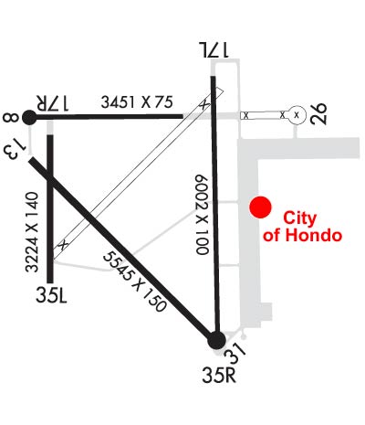 Airport Diagram might not be current. | |
| Facility Name: | SOUTH TEXAS RGNL AT HONDO |
| City Name: | HONDO |
| County: | MEDINA |
| State abbrev: | TX |
| State Name: | TEXAS |
| Ownership: | PUBLICLY OWNED |
| Use: | OPEN TO THE PUBLIC |
| Owner's Name: | CITY OF HONDO |
| Address: | 1600 AVENUE M |
| HONDO, TX 78861 | |
| Owner's Phone: | 830-426-3378 |
| Manager's Name: | RYAN ELDER |
| Address: | 700 VANDENBERG RD |
| HONDO, TX 78861 | |
| Phone: | 830-426-3810 |
| FAA Region: | SOUTHWEST |
| FAA Field Office: | TEX |
| Date | Sunrise | Sunset |
|---|---|---|
| 09/24/21 Friday | 7:26 | 19:31 |
| 09/25/21 Saturday | 7:27 | 19:30 |
| 09/26/21 Sunday | 7:27 | 19:29 |
| 09/27/21 Monday | 7:28 | 19:27 |
| 09/28/21 Tuesday | 7:28 | 19:26 |
| 09/29/21 Wednesday | 7:29 | 19:25 |
| 09/30/21 Thursday | 7:29 | 19:24 |
| 10/01/21 Friday | 7:30 | 19:23 |
| 10/02/21 Saturday | 7:30 | 19:21 |
| 10/03/21 Sunday | 7:31 | 19:20 |
| 10/04/21 Monday | 7:31 | 19:19 |
| 10/05/21 Tuesday | 7:32 | 19:18 |
| 10/06/21 Wednesday | 7:33 | 19:17 |
| 10/07/21 Thursday | 7:33 | 19:15 |
| Airport Attendance Schedule | MON-FRI 0730-1700 |
| Airport Status | OPERATIONAL (This Status can change at any time - please check NOTAMS) |
| Airport Lighting Schedule | SS-SR |
| Airport Storage Available | Tie Downs, Hanger |
| Extra Services Available | Avionics, Flight Instruction, Aircraft Sales |
| Wind Indicator | YES - (lighted) |
| Control Tower | NO |
| CTAF Frequency | 122.725 |
| Unicom Frequency | 122.725 |
| Rotating Beacon Color | CLEAR-GREEN (Light Land Airport) |
| Segmented Circle | YES |
| Landing Fee | NO |
| Airport Inspected | STATE - performed by STATE AERONAUTICAL PERSONNEL |
| Inspection Date | 02/15/2017 |
| Type of Fuel Available | Grade 100LL, JET A (freeze point -40C); -10SELF SERVICE FUEL AVBL 24 HRS. FULL SERVICE JET A AND AVGAS AVBL UPON REQUEST; CALL 830-426-3810. 2 HRS PN AFT HRS. |
| Airframe Repair Service | MINOR |
| Power Plant Repair Service | MINOR |
| Latitude | N2921.5 |
| Longitude | W09910.6 (ESTIMATED) |
| Arpt Elevation | 930ft (SURVEYED) |
| Magnetic Variation | 08E |
| 2 miles NW | of HONDO |
| Traffic Pattern Altitude | 800 |
| Sectional Chart | SAN ANTONIO |
| Operations (Reported) | Yearly | Avg. Daily |
|---|---|---|
| General Aviation Transient | 5000 | 14 |
| General Aviation Local | 20000 | 55 |
| Air Taxi | 0 | 0 |
| Commerical | 0 | 0 |
| Commuter | 0 | 0 |
| Military | 0 | 0 |
| Aircraft based on Field | |
|---|---|
| General Aviation Singles | 55 |
| General Aviation Multi | 4 |
| Jet Aircraft | 2 |
| General Aviation Helicopters | 3 |
| Military Aircraft | 0 |
| Gliders | 0 |
| Ultralights | 0 |
| FSS on field | NO |
| FSS tie-in | SAN ANGELO |
| FSS Phone | 1-800-WX-BRIEF |
| Who issues Notams | HDO |
| Notam D service at airport | YES |
| ARTCC Name | HOUSTON |
| Airport Certification | |
| Aircraft Rescue & Firefighting Index | None |
| Airport of Entry | No |
| Custom Landing Rights | No |
| Joint Civil/Military | No |
| Military Landing rights | No |
| NATIONAL PLAN OF INTEGRATED AIRPORT SYSTEMS (NPIAS) |
| SURPLUS PROPERTY AGREEMENT UNDER PUBLIC LAW 289 |
| DEER ON & INVOF ARPT. |
| CTC ARPT OPNS ON 121.95/123.3/123.5. |
| FOR CD CTC HOUSTON ARTCC AT 281-230-5622. |
| RWY 17R/ 35LCLSD TO ACFT OVER 12500 LBS. |
| RWY 08/2 6 RWY WID IS 75 FT WIDE AND UNMKD; OVERALL PAVEMENT WID IS 150 FT. |
Airport Communications & Frequencies:
| |||||||||
| Runway: 08 | Runway: 26 | ||
| Mag heading: | 82° | Mag heading: | 262° |
| Rwy Slope: | -.12% Down | Rwy Slope: | .12% Up |
| Approach: | Approach: | ||
| Pattern: | Left Traffic | Pattern: | Left Traffic |
| Markings: | BASIC | Markings: | BASIC |
| Marking Condition: | GOOD | Marking Condition: | GOOD |
| Arresting Dev: | Arresting Dev: | ||
| Lat & Long: | N2921.8 W09911.1 | Lat. & Long.: | N2921.8 W09910.4 |
| Elev: | 930.1 ft. MSL | Elev: | 926.0 ft. MSL |
| TCH: | TCH: | ||
| Visual Glide Path: | Visual Glide Path: | ||
| Displaced Threshold: | No | Displaced Threshold: | No |
| Touchdown Zone: | YES | Touchdown Zone: | YES |
| Touchdown Elev.: | 930.1 feet | Touchdown Elev.: | 927.5 feet |
| Visual Glide Slope: | Visual Glide Slope: | ||
| RVR Equipment: | RVR Equipment: | ||
| RVV Equipment: | NO | RVV Equipment: | NO |
| Approach Lights: | Approach Lights: | ||
| REIL: | NO | REIL: | NO |
| Centerline Lights: | NO | Centerline Lights: | NO |
| Touchdown lights: | NO | Touchdown lights: | NO |
| Runway Category: | Runway with a Visual Approach | Runway Category: | Runway with a Visual Approach |
| Declared Distances: | Declared Distances: |
| Runway: 13 | Runway: 31 | ||
| Mag heading: | 127° | Mag heading: | 307° |
| Rwy Slope: | -.28% Down | Rwy Slope: | .28% Up |
| Approach: | Approach: | ||
| Pattern: | Right Traffic | Pattern: | Left Traffic |
| Markings: | NONPRECISION INSTRUMENT | Markings: | NONPRECISION INSTRUMENT |
| Marking Condition: | GOOD | Marking Condition: | GOOD |
| Arresting Dev: | Arresting Dev: | ||
| Lat & Long: | N2921.7 W09911.1 | Lat. & Long.: | N2921.1 W09910.4 |
| Elev: | 927.3 ft. MSL | Elev: | 912.0 ft. MSL |
| TCH: | TCH: | ||
| Visual Glide Path: | Visual Glide Path: | ||
| Displaced Threshold: | 98 feet | Displaced Threshold: | No |
| Touchdown Zone: | YES | Touchdown Zone: | YES |
| Touchdown Elev.: | 927.2 feet | Touchdown Elev.: | 921.2 feet |
| Visual Glide Slope: | Visual Glide Slope: | ||
| RVR Equipment: | RVR Equipment: | ||
| RVV Equipment: | NO | RVV Equipment: | NO |
| Approach Lights: | Approach Lights: | ||
| REIL: | NO | REIL: | NO |
| Centerline Lights: | NO | Centerline Lights: | NO |
| Touchdown lights: | NO | Touchdown lights: | NO |
| Runway Category: | Runway with a Visual Approach | Runway Category: | Runway with a Visual Approach |
| Declared Distances: | Declared Distances: |
| Runway: 17L | Runway: 35R | ||
| Mag heading: | 172° | Mag heading: | 352° |
| Rwy Slope: | -.29% Down | Rwy Slope: | .29% Up |
| Approach: | Approach: | ||
| Pattern: | Left Traffic | Pattern: | Right Traffic |
| Markings: | NONPRECISION INSTRUMENT | Markings: | NONPRECISION INSTRUMENT |
| Marking Condition: | GOOD | Marking Condition: | GOOD |
| Arresting Dev: | Arresting Dev: | ||
| Lat & Long: | N2922.0 W09910.3 | Lat. & Long.: | N2921.1 W09910.3 |
| Elev: | 929.4 ft. MSL | Elev: | 911.7 ft. MSL |
| TCH: | 45 ft. AGL | TCH: | 45 ft. AGL |
| Visual Glide Path: | 3.00 degrees | Visual Glide Path: | 3.00 degrees |
| Displaced Threshold: | No | Displaced Threshold: | No |
| Touchdown Zone: | YES | Touchdown Zone: | YES |
| Touchdown Elev.: | 929.4 feet | Touchdown Elev.: | 917.3 feet |
| Visual Glide Slope: | 4-Light PAPI on LEFT side of Runway | Visual Glide Slope: | 4-Light PAPI on LEFT side of Runway |
| RVR Equipment: | RVR Equipment: | ||
| RVV Equipment: | NO | RVV Equipment: | NO |
| Approach Lights: | Approach Lights: | ||
| REIL: | NO | REIL: | NO |
| Centerline Lights: | NO | Centerline Lights: | NO |
| Touchdown lights: | NO | Touchdown lights: | NO |
| Runway Category: | Runway with a Non-precision Approach having visibility minimums greater than 3/4 mile | Runway Category: | Runway with a Non-precision Approach having visibility minimums greater than 3/4 mile |
| Declared Distances: | Declared Distances: |
| Runway: 17R | Runway: 35L | ||
| Mag heading: | 172° | Mag heading: | 352° |
| Rwy Slope: | -.34% Down | Rwy Slope: | .34% Up |
| Approach: | Approach: | ||
| Pattern: | Right Traffic | Pattern: | Left Traffic |
| Markings: | NONPRECISION INSTRUMENT | Markings: | NONPRECISION INSTRUMENT |
| Marking Condition: | GOOD | Marking Condition: | GOOD |
| Arresting Dev: | Arresting Dev: | ||
| Lat & Long: | N2921.8 W09911.0 | Lat. & Long.: | N2921.2 W09911.0 |
| Elev: | 927.9 ft. MSL | Elev: | 916.9 ft. MSL |
| TCH: | TCH: | ||
| Visual Glide Path: | Visual Glide Path: | ||
| Displaced Threshold: | No | Displaced Threshold: | No |
| Touchdown Zone: | YES | Touchdown Zone: | YES |
| Touchdown Elev.: | 927.9 feet | Touchdown Elev.: | 927.6 feet |
| Visual Glide Slope: | Visual Glide Slope: | ||
| RVR Equipment: | RVR Equipment: | ||
| RVV Equipment: | NO | RVV Equipment: | NO |
| Approach Lights: | Approach Lights: | ||
| REIL: | NO | REIL: | NO |
| Centerline Lights: | NO | Centerline Lights: | NO |
| Touchdown lights: | NO | Touchdown lights: | NO |
| Runway Category: | Runway with a Visual Approach | Runway Category: | Runway with a Visual Approach |
| Declared Distances: | Declared Distances: |
Thanks for using FltPlan.com
all rights reserved © 1999-2021 by Flight Plan LLC

