
| YAMPA VALLEY HAYDEN CO |
| |
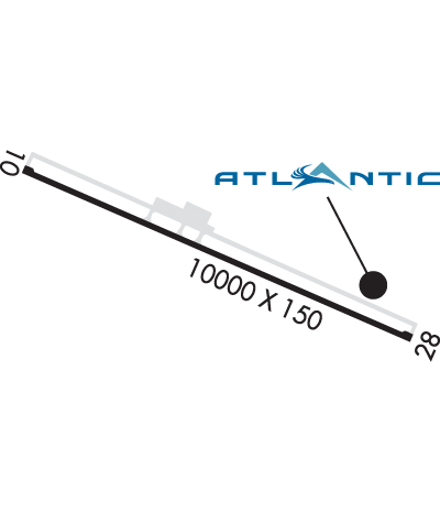
| Lat: N 4028.9 Long: W 10713.1 Elev: 6606 Var: -10 Longest Runway: 10000 | ||
| AWOS: 119.27 CTAF: 123.0 | ||
| |||||||||||||||||||||||||||||||||||||||||||||||||||||||||||||
| |||||||||||||||||||||||||||||||||||||||||||||||||||||||||||||
| |||||||||||||||||||||||||||||||||||||||||||||||||||||||||||||
| |||||||||||||||||||||||||||||||||||||||||||||||||||||||||||||
| Rwy | Rwy | |||||||
| 10000x150 | 9490' | 109.90 - 103° | 10000x150 | 10000' | ||||
| Runway ID | Single Wheel | Double Wheel | Double Tandem Wheel | Dual Double Wheel |
| 10/28 | 75,000 | 170,000 | 260,000 | N/A |
| These numbers are Advisory and are not limits. The Airport Manager should have more accurate Weight Limits | ||||
 Airport Diagram might not be current. | |
| Facility Name: | YAMPA VALLEY |
| City Name: | HAYDEN |
| County: | ROUTT |
| State abbrev: | CO |
| State Name: | COLORADO |
| Ownership: | PUBLICLY OWNED |
| Use: | OPEN TO THE PUBLIC |
| Owner's Name: | ROUTT COUNTY |
| Address: | PO BOX 773598 |
| STEAMBOAT SPRNGS 80477 | |
| Owner's Phone: | 970-879-0108 |
| Manager's Name: | TINNEAL GERBER |
| Address: | 11005 RCR 51A, PO BOX 1060 |
| HAYDEN, CO 81639 | |
| Phone: | 970-276-5021 |
| FAA Region: | NORTHWEST MOUNTAIN |
| FAA Field Office: | DEN |
| Date | Sunrise | Sunset |
|---|---|---|
| 06/08/26 Monday | 5:38 | 20:38 |
| 06/09/26 Tuesday | 5:38 | 20:38 |
| 06/10/26 Wednesday | 5:38 | 20:39 |
| 06/11/26 Thursday | 5:38 | 20:39 |
| 06/12/26 Friday | 5:38 | 20:40 |
| 06/13/26 Saturday | 5:38 | 20:40 |
| 06/14/26 Sunday | 5:38 | 20:41 |
| 06/15/26 Monday | 5:38 | 20:41 |
| 06/16/26 Tuesday | 5:38 | 20:41 |
| 06/17/26 Wednesday | 5:38 | 20:42 |
| 06/18/26 Thursday | 5:38 | 20:42 |
| 06/19/26 Friday | 5:38 | 20:42 |
| 06/20/26 Saturday | 5:38 | 20:42 |
| 06/21/26 Sunday | 5:39 | 20:43 |
| Airport Attendance Schedule | 7 Days A Week 0600-2100 |
| Airport Status | OPERATIONAL (This Status can change at any time - please check NOTAMS) |
| Airport Lighting Schedule | ACTVT MALSF RWY 10; REIL RWY 28; PAPI RWY 10; HIRL RWY 10/28 - CTAF. |
| Airport Storage Available | Tie Downs, Hanger |
| Extra Services Available | Air Freight, Air Ambulance |
| Wind Indicator | YES - (lighted) |
| Control Tower | NO |
| CTAF Frequency | 123.000 |
| Unicom Frequency | 123.000; BTN 0600 - 2000 CTC UNICOM PRIOR TO ALL TKFS AND LNDGS FOR PAEW ADVISORIES. |
| Rotating Beacon Color | WG |
| Segmented Circle | YES |
| Landing Fee | YES; LANDING FEE FOR ACFT 12,500 LBS & OVER. |
| Airport Inspected | FEDERAL - performed by FAA AIRPORTS FIELD PERSONNEL |
| Inspection Date | 07/30/2025 |
| Type of Fuel Available | Grade 100LL, JET A (freeze point -40C) |
| Airframe Repair Service | NONE |
| Power Plant Repair Service | NONE |
| Latitude | N4028.9 |
| Longitude | W10713.1 (ESTIMATED) |
| Arpt Elevation | 6606ft (SURVEYED) |
| Magnetic Variation | 10E |
| 2 miles SE | of HAYDEN |
| Traffic Pattern Altitude | |
| Sectional Chart | CHEYENNE |
| Operations (Reported) | Yearly | Avg. Daily |
|---|---|---|
| General Aviation Transient | 0 | 0 |
| General Aviation Local | 0 | 0 |
| Air Taxi | 0 | 0 |
| Commerical | 0 | 0 |
| Commuter | 0 | 0 |
| Military | 0 | 0 |
| Aircraft based on Field | |
|---|---|
| General Aviation Singles | 0 |
| General Aviation Multi | 0 |
| Jet Aircraft | 0 |
| General Aviation Helicopters | 0 |
| Military Aircraft | 0 |
| Gliders | 0 |
| Ultralights | 0 |
| FSS on field | NO |
| FSS tie-in | DENVER |
| FSS Phone | 1-800-WX-BRIEF |
| Who issues Notams | HDN |
| Notam D service at airport | YES |
| ARTCC Name | DENVER |
| Airport Certification | AIRPORT RECEIVING SCHEDULED AIR CARRIER SERVICE FROM CARRIERS CERTIFICATED BY THE CIVIL AERONAUTICS BOARD; CLSD TO UNSKED ACR OPNS WITH MORE THAN 30 PSGR SEATS EXCP PPR; CALL UNICOM 970-819-1333. |
| Aircraft Rescue & Firefighting Index | AIRPORT HAS A CERTIFICATE UNDER CFR PART 139 |
| Airport of Entry | No |
| Custom Landing Rights | No |
| Joint Civil/Military | No |
| Military Landing rights | YES |
| NATIONAL PLAN OF INTEGRATED AIRPORT SYSTEMS (NPIAS) |
| GRANT AGREEMENTS UNDER FAAP/ADAP/AIP |
| ASSURANCES PURSUANT TO TITLE VI, CIVIL RIGHTS ACT OF 1964 |
| REQ ALL ACFT DEPG RWY 28 MAKE RGT OR LEFT TURNOUT AS SOON AS SAFETY PERMITS AFTER TAKEOFF TO AVOID TOWN OF HAYDEN & COMPLY WITH NOISE ABATEMENT PROCS. |
| NO ARFF INDEX 2100-0600 UNLESS EXTN APVD BY ARPT NLT 2300. |
| ARFF INDEX B APR 16-DEC 14 0600-2100. ARFF INDEX C DEC 15-APR 15 0600-2100. |
| LARGE FLOCKS OF SANDHILL CRANES AROUND ARPT IN SPRING AND FALL. |
| ALL ACFT REPORT 10 MINUTES PRIOR TO TKOF/LNDG ON 123.0 - MONITOR FREQ 24 HRS, PAEW ON RWY. |
| POSSIBLE SEVERE WINTER CONDITIONS FROM OCT-APR. CHECK NOTAMS FOR ARPT CONDITIONS. NO ARPT INFORMATION NOR SNOW REMOVAL GUARANTEED DURING HOURS OF NONATTENDANCE. |
| RWY 28 PAPI DOES NOT PROVIDE OBST CLEARANCE BEYOND 4.0 NM FROM THRESHOLD. |
| RWY 10/2 8 PCR VALUE: 600/F/D/X/T |
Airport Communications & Frequencies:
| |||||||||
| Runway: 10 | Runway: 28 | ||
| Mag heading: | 104° | Mag heading: | 284° |
| Rwy Slope: | .26% Up | Rwy Slope: | -.26% Down |
| Approach: | ILS/DME | Approach: | |
| Pattern: | Right Traffic | Pattern: | Left Traffic |
| Markings: | PRECISION INSTRUMENT | Markings: | PRECISION INSTRUMENT |
| Marking Condition: | GOOD | Marking Condition: | GOOD |
| Arresting Dev: | Arresting Dev: | ||
| Lat & Long: | N4029.2 W10714.0 | Lat. & Long.: | N4028.5 W10712.1 |
| Elev: | 6580.4 ft. MSL | Elev: | 6606.2 ft. MSL |
| TCH: | 52 ft. AGL | TCH: | 54 ft. AGL |
| Visual Glide Path: | 3.00 degrees | Visual Glide Path: | 3.50 degrees |
| Displaced Threshold: | 510 feet | Displaced Threshold: | No |
| Touchdown Zone: | YES | Touchdown Zone: | YES |
| Touchdown Elev.: | 6591.4 feet | Touchdown Elev.: | 6606.3 feet |
| Visual Glide Slope: | 4-Light PAPI on LEFT side of Runway | Visual Glide Slope: | 4-Light PAPI on LEFT side of Runway |
| RVR Equipment: | RVR Equipment: | ||
| RVV Equipment: | NO | RVV Equipment: | NO |
| Approach Lights: | MALSF - 1,400 foot medium intensity approach lighting system with sequenced flashers | Approach Lights: | |
| REIL: | NO | REIL: | YES |
| Centerline Lights: | NO | Centerline Lights: | NO |
| Touchdown lights: | NO | Touchdown lights: | NO |
| Runway Category: | Precision Instrument Runway | Runway Category: | Runway with a Non-precision Approach having visibility minimums greater than 3/4 mile |
| Declared Distances: | TORA:10000' TODA:10000' ASDA:10000' LDA:9490' | Declared Distances: | TORA:10000' TODA:10000' ASDA:10000' LDA:10000' |
| Obstructions: | Obstructions: | PLINE | |
| Marked: | Marked: | MARKED | |
| Clearance slope: | 50:1; OBSTRUCTION CLNC SLOPE 50:1 TO DSPLCD THLD. | Clearance slope: | 34:1 |
| Obstruction height: | Obstruction height: | 110 feet AGL | |
| Dist. from runway: | Dist. from runway: | 3850 feet | |
| Centerline offset: | Centerline offset: | ||
| Comments: | Comments: |
Thanks for using FltPlan.com
all rights reserved © 1999-2026 by Flight Plan LLC


