
| BREWSTER FIELD HOLDREGE NE |
| |
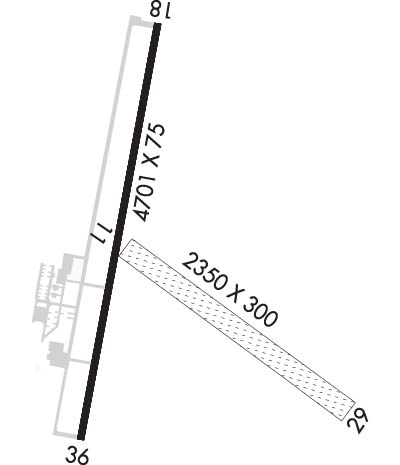
| Lat: N 4027.1 Long: W 09920.2 Elev: 2313 Var: -07 Longest Runway: 4701 | ||
| AWOS: 121.32 CTAF: 122.8 | ||
| ||||||
| ||||||
|
| Rwy | Rwy | |||||||
| 2350x300 | 2350' | 2350x300 | 2350' | |||||
| 4701x75 | 4701' | 4701x75 | 4701' | |||||
| Runway ID | Single Wheel | Double Wheel | Double Tandem Wheel | Dual Double Wheel |
| 11/29 | N/A | N/A | N/A | N/A |
| 18/36 | 30,000 | N/A | N/A | N/A |
| These numbers are Advisory and are not limits. The Airport Manager should have more accurate Weight Limits | ||||
 Airport Diagram might not be current. | |
| Facility Name: | BREWSTER FLD |
| City Name: | HOLDREGE |
| County: | PHELPS |
| State abbrev: | NE |
| State Name: | NEBRASKA |
| Ownership: | PUBLICLY OWNED |
| Use: | OPEN TO THE PUBLIC |
| Owner's Name: | HOLDREGE AIRPORT AUTHORITY |
| Address: | 1320 BREWSTER ROAD |
| HOLDREGE, NE 68949-1571 | |
| Owner's Phone: | 308-991-1455; DOROTHY ANDERSON CHAIRMAN. |
| Manager's Name: | DAN POWERS |
| Address: | 1320 BREWSTER ROAD |
| HOLDREGE, NE 68949-1571 | |
| Phone: | (308) 991-3641 |
| FAA Region: | CENTRAL |
| FAA Field Office: | NONE |
| Date | Sunrise | Sunset |
|---|---|---|
| 09/24/21 Friday | 7:27 | 19:31 |
| 09/25/21 Saturday | 7:28 | 19:30 |
| 09/26/21 Sunday | 7:29 | 19:28 |
| 09/27/21 Monday | 7:30 | 19:26 |
| 09/28/21 Tuesday | 7:31 | 19:25 |
| 09/29/21 Wednesday | 7:32 | 19:23 |
| 09/30/21 Thursday | 7:33 | 19:21 |
| 10/01/21 Friday | 7:34 | 19:20 |
| 10/02/21 Saturday | 7:35 | 19:18 |
| 10/03/21 Sunday | 7:36 | 19:17 |
| 10/04/21 Monday | 7:37 | 19:15 |
| 10/05/21 Tuesday | 7:38 | 19:13 |
| 10/06/21 Wednesday | 7:39 | 19:12 |
| 10/07/21 Thursday | 7:40 | 19:10 |
| Airport Attendance Schedule | MON-FRI 0800-1700 |
| Airport Status | OPERATIONAL (This Status can change at any time - please check NOTAMS) |
| Airport Lighting Schedule | MIRL RWY 18/36 PRESET LOW INTST; TO INCR INTST & ACTVT REIL & PAPI RWYS 18 & 36 - CTAF. |
| Airport Storage Available | Tie Downs, Hanger |
| Extra Services Available | Crop Dusting, Flight Instruction, Parachute Jumping, Aircraft Rental, Annual Surveying |
| Wind Indicator | YES - (lighted) |
| Control Tower | NO |
| CTAF Frequency | 122.800 |
| Unicom Frequency | 122.800 |
| Rotating Beacon Color | CLEAR-GREEN (Light Land Airport) |
| Segmented Circle | YES |
| Landing Fee | NO |
| Airport Inspected | STATE - performed by STATE AERONAUTICAL PERSONNEL |
| Inspection Date | 07/21/2020 |
| Type of Fuel Available | Grade 100LL, JET A (freeze point -40C); -10100LL 24 HR SELF SVC FUEL AVBL VIA CREDIT CARD SYSTEM.; -A CALL FOR JET A SERVICE. FOR SERVICE AND ATTENDANT AFTER HOURS CALL 308-995-7895. IF NO ANSWER, CALL 308-991-5803. |
| Airframe Repair Service | MAJOR |
| Power Plant Repair Service | MAJOR |
| Latitude | N4027.1 |
| Longitude | W09920.2 (ESTIMATED) |
| Arpt Elevation | 2313ft (ESTIMATED) |
| Magnetic Variation | 07E |
| 2 miles NE | of HOLDREGE |
| Traffic Pattern Altitude | |
| Sectional Chart | OMAHA |
| Operations (Reported) | Yearly | Avg. Daily |
|---|---|---|
| General Aviation Transient | 6000 | 16 |
| General Aviation Local | 10000 | 27 |
| Air Taxi | 0 | 0 |
| Commerical | 0 | 0 |
| Commuter | 0 | 0 |
| Military | 0 | 0 |
| Aircraft based on Field | |
|---|---|
| General Aviation Singles | 20 |
| General Aviation Multi | 2 |
| Jet Aircraft | 2 |
| General Aviation Helicopters | 1 |
| Military Aircraft | 0 |
| Gliders | 0 |
| Ultralights | 0 |
| FSS on field | NO |
| FSS tie-in | COLUMBUS |
| FSS Phone | 1-800-WX-BRIEF |
| Who issues Notams | HDE |
| Notam D service at airport | YES |
| ARTCC Name | DENVER |
| Airport Certification | |
| Aircraft Rescue & Firefighting Index | None |
| Airport of Entry | No |
| Custom Landing Rights | No |
| Joint Civil/Military | No |
| Military Landing rights | YES |
| NATIONAL PLAN OF INTEGRATED AIRPORT SYSTEMS (NPIAS) |
| GRANT AGREEMENTS UNDER FAAP/ADAP/AIP |
| ASSURANCES PURSUANT TO TITLE VI, CIVIL RIGHTS ACT OF 1964 |
| WATERFOWL INVOF ARPT. |
| EXTENSIVE CROP SPRAYING OPNS INVOF ARPT APR THRU AUG. |
| RWY 11/29 NOT PLOWED WINT MONTHS. |
| RWY 18 DSGND CALM WND RWY. |
| PRCHT JUMPING |
| FOR CD CTC DENVER ARTCC AT 303-651-4257. |
| RWY 18/3 6 S 3100 FT & CENTER 50 FT ASPH. |
Airport Communications & Frequencies:
| |||||||||
| Runway: 11 | Runway: 29 | ||
| Mag heading: | 119° | Mag heading: | 299° |
| Rwy Slope: | .27% Up | Rwy Slope: | -.27% Down |
| Approach: | Approach: | ||
| Pattern: | Left Traffic | Pattern: | Left Traffic |
| Markings: | Markings: | ||
| Marking Condition: | RWY 11 /29 MKD; BOUNDARY CONES ON RWY ENDS. | Marking Condition: | |
| Arresting Dev: | Arresting Dev: | ||
| Lat & Long: | N4027.1 W09920.2 | Lat. & Long.: | N4026.9 W09919.8 |
| Elev: | 2306.8 ft. MSL | Elev: | 2313.1 ft. MSL |
| TCH: | TCH: | ||
| Visual Glide Path: | Visual Glide Path: | ||
| Displaced Threshold: | No | Displaced Threshold: | No |
| Touchdown Zone: | YES | Touchdown Zone: | YES |
| Touchdown Elev.: | 2313.0 feet | Touchdown Elev.: | 2313.1 feet |
| Visual Glide Slope: | Visual Glide Slope: | ||
| RVR Equipment: | RVR Equipment: | ||
| RVV Equipment: | NO | RVV Equipment: | NO |
| Approach Lights: | Approach Lights: | ||
| REIL: | NO | REIL: | NO |
| Centerline Lights: | NO | Centerline Lights: | NO |
| Touchdown lights: | NO | Touchdown lights: | NO |
| Runway Category: | Runway with a Visual Approach | Runway Category: | Runway with a Visual Approach |
| Declared Distances: | Declared Distances: | ||
| Obstructions: | TREE | Obstructions: | TREE |
| Marked: | NOT Marked/Lighted | Marked: | NOT Marked/Lighted |
| Clearance slope: | 30:1 | Clearance slope: | 47:1 |
| Obstruction height: | 38 feet AGL | Obstruction height: | 27 feet AGL |
| Dist. from runway: | 1151 feet | Dist. from runway: | 1278 feet |
| Centerline offset: | 211 right of centerline | Centerline offset: | 104 feet left of centerline |
| Comments: | Comments: |
| Runway: 18 | Runway: 36 | ||
| Mag heading: | 183° | Mag heading: | 3° |
| Rwy Slope: | .04% Up | Rwy Slope: | -.04% Down |
| Approach: | Approach: | ||
| Pattern: | Left Traffic | Pattern: | Left Traffic |
| Markings: | NONPRECISION INSTRUMENT | Markings: | NONPRECISION INSTRUMENT |
| Marking Condition: | GOOD | Marking Condition: | GOOD |
| Arresting Dev: | Arresting Dev: | ||
| Lat & Long: | N4027.5 W09920.2 | Lat. & Long.: | N4026.8 W09920.3 |
| Elev: | 2305.9 ft. MSL | Elev: | 2307.8 ft. MSL |
| TCH: | 40 ft. AGL | TCH: | 40 ft. AGL |
| Visual Glide Path: | 3.00 degrees | Visual Glide Path: | 3.00 degrees |
| Displaced Threshold: | No | Displaced Threshold: | No |
| Touchdown Zone: | YES | Touchdown Zone: | YES |
| Touchdown Elev.: | 2309.3 feet | Touchdown Elev.: | 2309.3 feet |
| Visual Glide Slope: | 2-Light PAPI on LEFT side of Runway | Visual Glide Slope: | 2-Light PAPI on LEFT side of Runway |
| RVR Equipment: | RVR Equipment: | ||
| RVV Equipment: | NO | RVV Equipment: | NO |
| Approach Lights: | Approach Lights: | ||
| REIL: | YES | REIL: | YES |
| Centerline Lights: | NO | Centerline Lights: | NO |
| Touchdown lights: | NO | Touchdown lights: | NO |
| Runway Category: | Runway with a Non-precision Approach having visibility minimums greater than 3/4 mile | Runway Category: | Runway with a Non-precision Approach having visibility minimums greater than 3/4 mile |
| Declared Distances: | Declared Distances: | ||
| Obstructions: | RWY 18 CTLG OBSTN CENTER PIVOT IRRIGATOR ROTATES THROUGH APCH DURING IRRIGATION SEASON | Obstructions: | RR |
| Marked: | NOT Marked/Lighted; RWY 18 CNTR PIVOTS ROTN THRU APCH CAN CREATE SLOPE AS LOW AS 15:1 DURG IRRIGATION SEASON. | Marked: | NOT Marked/Lighted |
| Clearance slope: | 34:1 | Clearance slope: | 35:1 |
| Obstruction height: | Obstruction height: | 26 feet AGL | |
| Dist. from runway: | Dist. from runway: | 1115 feet | |
| Centerline offset: | Centerline offset: | ||
| Comments: | Comments: |
Thanks for using FltPlan.com
all rights reserved © 1999-2021 by Flight Plan LLC
