
| JIM HOGG COUNTY HEBBRONVILLE TX |
| |
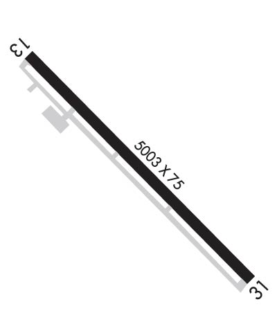
| Lat: N 2721.0 Long: W 09844.2 Elev: 663 Var: -06 Longest Runway: 5003 | ||
| AWOS: 118.07 CTAF: 122.8 | ||
| ||||||
| ||||||
|
| Rwy | Rwy | |||||||
| 5003x75 | 5003' | 5003x75 | 5003' | |||||
| Runway ID | Single Wheel | Double Wheel | Double Tandem Wheel | Dual Double Wheel |
| 13/31 | 30,000 | 72,000 | N/A | N/A |
| These numbers are Advisory and are not limits. The Airport Manager should have more accurate Weight Limits | ||||
 Airport Diagram might not be current. | |
| Facility Name: | JIM HOGG COUNTY |
| City Name: | HEBBRONVILLE |
| County: | JIM HOGG |
| State abbrev: | TX |
| State Name: | TEXAS |
| Ownership: | PUBLICLY OWNED |
| Use: | OPEN TO THE PUBLIC |
| Owner's Name: | JIM HOGG COUNTY; HUMBERTO GONZALES, COUNTY JUDGE |
| Address: | PO BOX 729 |
| HEBBRONVILLE, TX 78361 | |
| Owner's Phone: | 361-527-3015 |
| Manager's Name: | CLARK ROSSI |
| Address: | PO BOX 24 |
| HEBBRONVILLE, TX 78361 | |
| Phone: | 956-693-7751; OR 361-527-4461 |
| FAA Region: | SOUTHWEST |
| FAA Field Office: | TEX |
| Date | Sunrise | Sunset |
|---|---|---|
| 09/24/21 Friday | 7:24 | 19:29 |
| 09/25/21 Saturday | 7:25 | 19:28 |
| 09/26/21 Sunday | 7:25 | 19:27 |
| 09/27/21 Monday | 7:26 | 19:26 |
| 09/28/21 Tuesday | 7:26 | 19:25 |
| 09/29/21 Wednesday | 7:27 | 19:24 |
| 09/30/21 Thursday | 7:27 | 19:22 |
| 10/01/21 Friday | 7:28 | 19:21 |
| 10/02/21 Saturday | 7:28 | 19:20 |
| 10/03/21 Sunday | 7:28 | 19:19 |
| 10/04/21 Monday | 7:29 | 19:18 |
| 10/05/21 Tuesday | 7:29 | 19:17 |
| 10/06/21 Wednesday | 7:30 | 19:16 |
| 10/07/21 Thursday | 7:30 | 19:15 |
| Airport Attendance Schedule | UNATTENDED; ATTENDANT ON CALL. |
| Airport Status | OPERATIONAL (This Status can change at any time - please check NOTAMS) |
| Airport Lighting Schedule | MIRL RWY 13/31 PRESET LOW INTST; TO INCR INTST ACTVT - CTAF. PAPI RWY 13 OPRS CONSLY. |
| Airport Storage Available | Tie Downs |
| Extra Services Available | NONE |
| Wind Indicator | YES - (lighted) |
| Control Tower | NO |
| CTAF Frequency | 122.800 |
| Unicom Frequency | 122.800 |
| Rotating Beacon Color | CLEAR-GREEN (Light Land Airport) |
| Segmented Circle | YES |
| Landing Fee | NO |
| Airport Inspected | STATE - performed by PRIVATE CONTRACT PERSONNEL |
| Inspection Date | 05/07/2020 |
| Type of Fuel Available | JET A (freeze point -40C); -A FOR JET A, CALL 361-850-3430. |
| Airframe Repair Service | NONE |
| Power Plant Repair Service | NONE |
| Latitude | N2721.0 |
| Longitude | W09844.2 (ESTIMATED) |
| Arpt Elevation | 662ft (SURVEYED) |
| Magnetic Variation | 06E |
| 3 miles NW | of HEBBRONVILLE |
| Traffic Pattern Altitude | |
| Sectional Chart | BROWNSVILLE |
| Operations (Reported) | Yearly | Avg. Daily |
|---|---|---|
| General Aviation Transient | 350 | 1 |
| General Aviation Local | 120 | 0 |
| Air Taxi | 0 | 0 |
| Commerical | 0 | 0 |
| Commuter | 0 | 0 |
| Military | 0 | 0 |
| Aircraft based on Field | |
|---|---|
| General Aviation Singles | 2 |
| General Aviation Multi | 0 |
| Jet Aircraft | 0 |
| General Aviation Helicopters | 0 |
| Military Aircraft | 0 |
| Gliders | 0 |
| Ultralights | 0 |
| FSS on field | NO |
| FSS tie-in | SAN ANGELO |
| FSS Phone | 1-800-WX-BRIEF |
| Who issues Notams | HBV |
| Notam D service at airport | YES |
| ARTCC Name | HOUSTON |
| Airport Certification | |
| Aircraft Rescue & Firefighting Index | None |
| Airport of Entry | No |
| Custom Landing Rights | No |
| Joint Civil/Military | No |
| Military Landing rights | No |
| NATIONAL PLAN OF INTEGRATED AIRPORT SYSTEMS (NPIAS) |
| GRANT AGREEMENTS UNDER FAAP/ADAP/AIP |
| ASSURANCES PURSUANT TO TITLE VI, CIVIL RIGHTS ACT OF 1964 |
| THIS AIRPORT HAS BEEN SURVEYED BY THE NATIONAL GEODETIC SURVEY. |
| LRG ACFT EXITING RWY 31 SHOULD BACK TAXI ON RWY DUE TO OBSTN ON TWY. |
| FOR CD CTC HOUSTON ARTCC AT 281-230-5622. |
| RWY 13/3 1 GWT PAVEMENT STRENGTH PRVDD BY ARPT MGR. |
Airport Communications & Frequencies:
| |||||||||
| Runway: 13 | Runway: 31 | ||
| Mag heading: | 128° | Mag heading: | 308° |
| Rwy Slope: | .04% Up | Rwy Slope: | -.04% Down |
| Approach: | Approach: | ||
| Pattern: | Left Traffic | Pattern: | Left Traffic |
| Markings: | NONPRECISION INSTRUMENT | Markings: | NONPRECISION INSTRUMENT |
| Marking Condition: | GOOD | Marking Condition: | GOOD |
| Arresting Dev: | Arresting Dev: | ||
| Lat & Long: | N2721.3 W09844.5 | Lat. & Long.: | N2720.7 W09843.9 |
| Elev: | 660.9 ft. MSL | Elev: | 662.8 ft. MSL |
| TCH: | 39 ft. AGL | TCH: | 43 ft. AGL |
| Visual Glide Path: | 3.00 degrees | Visual Glide Path: | 3.00 degrees |
| Displaced Threshold: | No | Displaced Threshold: | No |
| Touchdown Zone: | YES | Touchdown Zone: | YES |
| Touchdown Elev.: | 660.9 feet | Touchdown Elev.: | 662.8 feet |
| Visual Glide Slope: | 2-Light PAPI on LEFT side of Runway | Visual Glide Slope: | 2-Light PAPI on LEFT side of Runway |
| RVR Equipment: | RVR Equipment: | ||
| RVV Equipment: | NO | RVV Equipment: | NO |
| Approach Lights: | Approach Lights: | ||
| REIL: | NO | REIL: | NO |
| Centerline Lights: | NO | Centerline Lights: | NO |
| Touchdown lights: | NO | Touchdown lights: | NO |
| Runway Category: | Runway with a Non-precision Approach having visibility minimums greater than 3/4 mile | Runway Category: | Runway with a Visual Approach |
| Declared Distances: | Declared Distances: | ||
| Obstructions: | TREES | Obstructions: | FENCE |
| Marked: | MARKED and LIGHTED | Marked: | MARKED and LIGHTED |
| Clearance slope: | 17:1 | Clearance slope: | 18:1 |
| Obstruction height: | 12 feet AGL | Obstruction height: | 9 feet AGL |
| Dist. from runway: | 405 feet | Dist. from runway: | 365 feet |
| Centerline offset: | 34 right of centerline | Centerline offset: | |
| Comments: | Comments: |
Thanks for using FltPlan.com
all rights reserved © 1999-2021 by Flight Plan LLC
