| HOBART RGNL HOBART OK |
| |
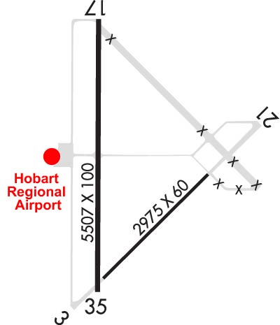
| Lat: N 3459.4 Long: W 09903.2 Elev: 1563 Var: -07 Longest Runway: 5507 | ||
| AWOS: 133.32 CTAF: 122.8 | ||
| ||||||||||||||||||||||||||||||
| ||||||||||||||||||||||||||||||
| ||||||||||||||||||||||||||||||
| Rwy | Rwy | |||||||
| 2975x60 | 2975' | 2975x60 | 2975' | |||||
| 5507x100 | 5507' | 5507x100 | 5507' | |||||
| Runway ID | Single Wheel | Double Wheel | Double Tandem Wheel | Dual Double Wheel |
| 03/21 | 9,400 | N/A | N/A | N/A |
| 17/35 | 20,000 | N/A | N/A | N/A |
| These numbers are Advisory and are not limits. The Airport Manager should have more accurate Weight Limits | ||||
 Airport Diagram might not be current. | |
| Facility Name: | HOBART RGNL |
| City Name: | HOBART |
| County: | KIOWA |
| State abbrev: | OK |
| State Name: | OKLAHOMA |
| Ownership: | PUBLICLY OWNED |
| Use: | OPEN TO THE PUBLIC |
| Owner's Name: | CITY OF HOBART |
| Address: | PO BOX 231 |
| HOBART, OK 73651 | |
| Owner's Phone: | 580-726-3100 |
| Manager's Name: | KEVIN MAGRADY |
| Address: | 22019 E 1396 RD |
| HOBART, OK 73651 | |
| Phone: | 580-726-2719 |
| FAA Region: | SOUTHWEST |
| FAA Field Office: | AOK |
| Date | Sunrise | Sunset |
|---|---|---|
| 06/08/26 Monday | 6:22 | 20:49 |
| 06/09/26 Tuesday | 6:22 | 20:49 |
| 06/10/26 Wednesday | 6:22 | 20:50 |
| 06/11/26 Thursday | 6:22 | 20:50 |
| 06/12/26 Friday | 6:22 | 20:50 |
| 06/13/26 Saturday | 6:22 | 20:51 |
| 06/14/26 Sunday | 6:22 | 20:51 |
| 06/15/26 Monday | 6:22 | 20:52 |
| 06/16/26 Tuesday | 6:22 | 20:52 |
| 06/17/26 Wednesday | 6:22 | 20:52 |
| 06/18/26 Thursday | 6:22 | 20:53 |
| 06/19/26 Friday | 6:22 | 20:53 |
| 06/20/26 Saturday | 6:22 | 20:53 |
| 06/21/26 Sunday | 6:23 | 20:53 |
| Airport Attendance Schedule | MON-FRI 0800-1600 |
| Airport Status | OPERATIONAL (This Status can change at any time - please check NOTAMS) |
| Airport Lighting Schedule | SS-SR |
| Airport Storage Available | Tie Downs |
| Extra Services Available | Crop Dusting |
| Wind Indicator | YES - (lighted) |
| Control Tower | NO |
| CTAF Frequency | 122.800 |
| Unicom Frequency | 122.800 |
| Rotating Beacon Color | WG |
| Segmented Circle | YES |
| Landing Fee | NO |
| Airport Inspected | STATE - performed by STATE AERONAUTICAL PERSONNEL |
| Inspection Date | 04/27/2023 |
| Type of Fuel Available | Grade 100LL, JET A; -10FUEL AVBL 24 HR SELF SERVICE WITH MAJOR CREDIT CARD. |
| Airframe Repair Service | NONE |
| Power Plant Repair Service | NONE |
| Latitude | N3459.4 |
| Longitude | W09903.2 (ESTIMATED) |
| Arpt Elevation | 1563ft (SURVEYED) |
| Magnetic Variation | 07E |
| 3 miles SE | of HOBART |
| Traffic Pattern Altitude | |
| Sectional Chart | DALLAS-FT WORTH |
| Operations (Reported) | Yearly | Avg. Daily |
|---|---|---|
| General Aviation Transient | 0 | 0 |
| General Aviation Local | 0 | 0 |
| Air Taxi | 0 | 0 |
| Commerical | 0 | 0 |
| Commuter | 0 | 0 |
| Military | 0 | 0 |
| Aircraft based on Field | |
|---|---|
| General Aviation Singles | 0 |
| General Aviation Multi | 0 |
| Jet Aircraft | 0 |
| General Aviation Helicopters | 0 |
| Military Aircraft | 0 |
| Gliders | 0 |
| Ultralights | 0 |
| FSS on field | NO |
| FSS tie-in | MC ALESTER |
| FSS Phone | 1-800-WX-BRIEF |
| Who issues Notams | HBR |
| Notam D service at airport | YES |
| ARTCC Name | FORT WORTH |
| Airport Certification | |
| Aircraft Rescue & Firefighting Index | None |
| Airport of Entry | No |
| Custom Landing Rights | No |
| Joint Civil/Military | No |
| Military Landing rights | YES |
| NATIONAL PLAN OF INTEGRATED AIRPORT SYSTEMS (NPIAS) |
| GRANT AGREEMENTS UNDER FAAP/ADAP/AIP |
| SURPLUS PROPERTY AGREEMENT UNDER PUBLIC LAW 289 |
| ASSURANCES PURSUANT TO TITLE VI, CIVIL RIGHTS ACT OF 1964 |
| AGREEMENT UNDER DLAND OR DCLA HAS EXPIRED. |
| FOR CD IF UNA TO CTC ON FSS FREQ, CTC FORT WORTH ARTCC AT 817-858-7584. |
Airport Communications & Frequencies:
| |||||||||||||||||
| Runway: 03 | Runway: 21 | ||
| Mag heading: | 38° | Mag heading: | 218° |
| Rwy Slope: | -.54% Down | Rwy Slope: | .54% Up |
| Approach: | Approach: | ||
| Pattern: | Left Traffic | Pattern: | Left Traffic |
| Markings: | BASIC | Markings: | BASIC |
| Marking Condition: | POOR; RWY 03 MARKINGS SVRLY FADED. | Marking Condition: | POOR; RWY 21 MARKINGS SVRLY FADED. |
| Arresting Dev: | Arresting Dev: | ||
| Lat & Long: | N3459.1 W09903.2 | Lat. & Long.: | N3459.4 W09902.8 |
| Elev: | 1560.8 ft. MSL | Elev: | 1544.7 ft. MSL |
| TCH: | TCH: | ||
| Visual Glide Path: | Visual Glide Path: | ||
| Displaced Threshold: | No | Displaced Threshold: | No |
| Touchdown Zone: | YES | Touchdown Zone: | YES |
| Touchdown Elev.: | 1560.8 feet | Touchdown Elev.: | 1560.8 feet |
| Visual Glide Slope: | Visual Glide Slope: | ||
| RVR Equipment: | RVR Equipment: | ||
| RVV Equipment: | NO | RVV Equipment: | NO |
| Approach Lights: | Approach Lights: | ||
| REIL: | NO | REIL: | NO |
| Centerline Lights: | NO | Centerline Lights: | NO |
| Touchdown lights: | NO | Touchdown lights: | NO |
| Runway Category: | Runway with a Visual Approach | Runway Category: | Runway with a Visual Approach |
| Declared Distances: | Declared Distances: |
| Runway: 17 | Runway: 35 | ||
| Mag heading: | 173° | Mag heading: | 353° |
| Rwy Slope: | .38% Up | Rwy Slope: | -.38% Down |
| Approach: | Approach: | ||
| Pattern: | Left Traffic | Pattern: | Left Traffic |
| Markings: | NONPRECISION INSTRUMENT | Markings: | NONPRECISION INSTRUMENT |
| Marking Condition: | GOOD | Marking Condition: | GOOD |
| Arresting Dev: | Arresting Dev: | ||
| Lat & Long: | N3459.9 W09903.3 | Lat. & Long.: | N3459.0 W09903.3 |
| Elev: | 1540.5 ft. MSL | Elev: | 1561.2 ft. MSL |
| TCH: | 35 ft. AGL | TCH: | 42 ft. AGL |
| Visual Glide Path: | 3.00 degrees | Visual Glide Path: | 3.00 degrees |
| Displaced Threshold: | No | Displaced Threshold: | No |
| Touchdown Zone: | YES | Touchdown Zone: | YES |
| Touchdown Elev.: | 1552.7 feet | Touchdown Elev.: | 1561.2 feet |
| Visual Glide Slope: | 4-Light PAPI on LEFT side of Runway | Visual Glide Slope: | 4-Light PAPI on LEFT side of Runway |
| RVR Equipment: | RVR Equipment: | ||
| RVV Equipment: | NO | RVV Equipment: | NO |
| Approach Lights: | Approach Lights: | ||
| REIL: | NO | REIL: | NO |
| Centerline Lights: | NO | Centerline Lights: | NO |
| Touchdown lights: | NO | Touchdown lights: | NO |
| Runway Category: | Runway with a Non-precision Approach having visibility minimums greater than 3/4 mile | Runway Category: | Runway with a Non-precision Approach having visibility minimums greater than 3/4 mile |
| Declared Distances: | Declared Distances: |
Thanks for using FltPlan.com
all rights reserved © 1999-2026 by Flight Plan LLC