
| THREE RIVERS MUNI DR HAINES THREE RIVERS MI |
| |
| Lat: N 4157.6 Long: W 08535.6 Elev: 823 Var: +04 Longest Runway: 4000 | ||
| AWOS: 119.97 CTAF: 122.8 | ||
| ||||||||||||||||||||||||||||||||||||||||||||
| ||||||||||||||||||||||||||||||||||||||||||||
| ||||||||||||||||||||||||||||||||||||||||||||
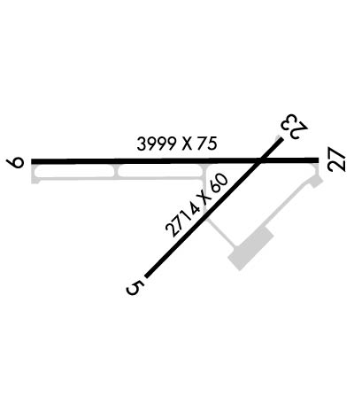
| Rwy | Rwy | |||||||
| 2719x60 | 2719' | 2719x60 | 2719' | |||||
| 4000x75 | 4000' | 4000x75 | 4000' | |||||
| Runway ID | Single Wheel | Double Wheel | Double Tandem Wheel | Dual Double Wheel |
| 05/23 | 16,000 | N/A | N/A | N/A |
| 09/27 | 26,000 | 30,000 | N/A | N/A |
| These numbers are Advisory and are not limits. The Airport Manager should have more accurate Weight Limits | ||||
 Airport Diagram might not be current. | |
| Facility Name: | THREE RIVERS MUNI/DR HAINES |
| City Name: | THREE RIVERS |
| County: | ST JOSEPH |
| State abbrev: | MI |
| State Name: | MICHIGAN |
| Ownership: | PUBLICLY OWNED |
| Use: | OPEN TO THE PUBLIC |
| Owner's Name: | CITY OF THREE RIVERS |
| Address: | MUNICIPAL BLDG, 333 W MICHIGAN AVE |
| THREE RIVERS, MI 49093-2193 | |
| Owner's Phone: | 269-273-1075 |
| Manager's Name: | DAN MILLER |
| Address: | 333 W MICHIGAN AVE |
| THREE RIVERS, MI 49093-2193 | |
| Phone: | 269-273-1845; CELL 269-506-3878. |
| FAA Region: | GREAT LAKES |
| FAA Field Office: | DET |
| Date | Sunrise | Sunset |
|---|---|---|
| 06/08/26 Monday | 6:07 | 21:16 |
| 06/09/26 Tuesday | 6:07 | 21:17 |
| 06/10/26 Wednesday | 6:07 | 21:17 |
| 06/11/26 Thursday | 6:06 | 21:18 |
| 06/12/26 Friday | 6:06 | 21:18 |
| 06/13/26 Saturday | 6:06 | 21:19 |
| 06/14/26 Sunday | 6:06 | 21:19 |
| 06/15/26 Monday | 6:06 | 21:19 |
| 06/16/26 Tuesday | 6:06 | 21:20 |
| 06/17/26 Wednesday | 6:06 | 21:20 |
| 06/18/26 Thursday | 6:06 | 21:21 |
| 06/19/26 Friday | 6:07 | 21:21 |
| 06/20/26 Saturday | 6:07 | 21:21 |
| 06/21/26 Sunday | 6:07 | 21:21 |
| Airport Attendance Schedule | UNATTENDED |
| Airport Status | OPERATIONAL (This Status can change at any time - please check NOTAMS) |
| Airport Lighting Schedule | ACTVT REIL RWY 09 & 27; PAPI RWY 09 & 27; MIRL RWY 05/23 & 09/27 - CTAF. |
| Airport Storage Available | Tie Downs |
| Extra Services Available | Flight Instruction, Aircraft Rental |
| Wind Indicator | YES - (lighted) |
| Control Tower | NO |
| CTAF Frequency | 122.800 |
| Unicom Frequency | 122.800 |
| Rotating Beacon Color | WG |
| Segmented Circle | YES |
| Landing Fee | NO |
| Airport Inspected | STATE - performed by STATE AERONAUTICAL PERSONNEL |
| Inspection Date | 06/13/2023 |
| Type of Fuel Available | Grade 100LL, JET A (freeze point -40C) |
| Airframe Repair Service | MAJOR |
| Power Plant Repair Service | MAJOR |
| Latitude | N4157.6 |
| Longitude | W08535.6 (ESTIMATED) |
| Arpt Elevation | 822ft (SURVEYED) |
| Magnetic Variation | 04W |
| 2 miles NE | of THREE RIVERS |
| Traffic Pattern Altitude | 1000 |
| Sectional Chart | CHICAGO |
| Operations (Reported) | Yearly | Avg. Daily |
|---|---|---|
| General Aviation Transient | 0 | 0 |
| General Aviation Local | 0 | 0 |
| Air Taxi | 0 | 0 |
| Commerical | 0 | 0 |
| Commuter | 0 | 0 |
| Military | 0 | 0 |
| Aircraft based on Field | |
|---|---|
| General Aviation Singles | 0 |
| General Aviation Multi | 0 |
| Jet Aircraft | 0 |
| General Aviation Helicopters | 0 |
| Military Aircraft | 0 |
| Gliders | 0 |
| Ultralights | 0 |
| FSS on field | NO |
| FSS tie-in | LANSING |
| FSS Phone | 1-800-WX-BRIEF |
| Who issues Notams | HAI |
| Notam D service at airport | YES |
| ARTCC Name | CHICAGO |
| Airport Certification | |
| Aircraft Rescue & Firefighting Index | None |
| Airport of Entry | No |
| Custom Landing Rights | No |
| Joint Civil/Military | No |
| Military Landing rights | YES |
| NATIONAL PLAN OF INTEGRATED AIRPORT SYSTEMS (NPIAS) |
| GRANT AGREEMENTS UNDER FAAP/ADAP/AIP |
| ASSURANCES PURSUANT TO TITLE VI, CIVIL RIGHTS ACT OF 1964 |
| ADMIN BLDG ACCESS, 5-3-2-1, OR 1-2-0-0. |
| FOR CD CTC GREAT LAKES APCH AT 269-459-3344, WHEN APCH CLSD CTC CHICAGO ARTCC AT 630-906-8921. |
| PSBL OF CROP IRRIGATION EQUIP OPERG NE APCH TO RWY 23. |
| RWY 23 15 FT VERT CLNC OVR ROAD IS WAIVED BY FAA. |
| RDO CTLD ACFT OPERATE .5 MI NW OF RWY 09. |
| RWY 5 15 FT VERT CLNC OVR ROAD WAIVED BY FAA (10/06/2009 ALP APVL LTR). |
| SNOW PLOWING SRY PRIORITY, CALL 269-273-1845 AMGR TO CFM CONDS. |
| DEER & LARGE BIRDS ON & INVOF ARPT. |
Airport Communications & Frequencies:
| |||||||||||||||||
| Runway: 05 | Runway: 23 | ||
| Mag heading: | 49° | Mag heading: | 229° |
| Rwy Slope: | -.06% Down | Rwy Slope: | .06% Up |
| Approach: | Approach: | ||
| Pattern: | Left Traffic | Pattern: | Left Traffic |
| Markings: | NONPRECISION INSTRUMENT | Markings: | NONPRECISION INSTRUMENT |
| Marking Condition: | GOOD | Marking Condition: | GOOD |
| Arresting Dev: | Arresting Dev: | ||
| Lat & Long: | N4157.4 W08535.7 | Lat. & Long.: | N4157.7 W08535.3 |
| Elev: | 822.5 ft. MSL | Elev: | 821.0 ft. MSL |
| TCH: | TCH: | ||
| Visual Glide Path: | Visual Glide Path: | ||
| Displaced Threshold: | No | Displaced Threshold: | No |
| Touchdown Zone: | YES | Touchdown Zone: | YES |
| Touchdown Elev.: | 822.7 feet | Touchdown Elev.: | 822.7 feet |
| Visual Glide Slope: | Visual Glide Slope: | ||
| RVR Equipment: | RVR Equipment: | ||
| RVV Equipment: | NO | RVV Equipment: | NO |
| Approach Lights: | Approach Lights: | ||
| REIL: | NO | REIL: | NO |
| Centerline Lights: | NO | Centerline Lights: | NO |
| Touchdown lights: | NO | Touchdown lights: | NO |
| Runway Category: | Runway with a Visual Approach | Runway Category: | Runway with a Visual Approach |
| Declared Distances: | Declared Distances: | ||
| Obstructions: | ROAD | Obstructions: | ROAD |
| Marked: | NOT Marked/Lighted | Marked: | NOT Marked/Lighted |
| Clearance slope: | 15:1 | Clearance slope: | 5:1 |
| Obstruction height: | 16 feet AGL | Obstruction height: | 13 feet AGL |
| Dist. from runway: | 450 feet | Dist. from runway: | 275 feet |
| Centerline offset: | 150 right of centerline | Centerline offset: | 130 feet right of centerline |
| Comments: | Comments: |
| Runway: 09 | Runway: 27 | ||
| Mag heading: | 94° | Mag heading: | 274° |
| Rwy Slope: | .06% Up | Rwy Slope: | -.06% Down |
| Approach: | Approach: | ||
| Pattern: | Left Traffic | Pattern: | Left Traffic |
| Markings: | NONPRECISION INSTRUMENT | Markings: | NONPRECISION INSTRUMENT |
| Marking Condition: | GOOD | Marking Condition: | GOOD |
| Arresting Dev: | Arresting Dev: | ||
| Lat & Long: | N4157.6 W08536.1 | Lat. & Long.: | N4157.6 W08535.2 |
| Elev: | 819.9 ft. MSL | Elev: | 822.4 ft. MSL |
| TCH: | 25 ft. AGL | TCH: | 34 ft. AGL |
| Visual Glide Path: | 3.00 degrees | Visual Glide Path: | 4.00 degrees |
| Displaced Threshold: | No | Displaced Threshold: | No |
| Touchdown Zone: | YES | Touchdown Zone: | YES |
| Touchdown Elev.: | 821.2 feet | Touchdown Elev.: | 822.5 feet |
| Visual Glide Slope: | 4-Light PAPI on LEFT side of Runway | Visual Glide Slope: | 4-Light PAPI on LEFT side of Runway |
| RVR Equipment: | RVR Equipment: | ||
| RVV Equipment: | NO | RVV Equipment: | NO |
| Approach Lights: | Approach Lights: | ||
| REIL: | YES | REIL: | YES |
| Centerline Lights: | NO | Centerline Lights: | NO |
| Touchdown lights: | NO | Touchdown lights: | NO |
| Runway Category: | Runway with a Visual Approach | Runway Category: | Runway with a Non-precision Approach |
| Declared Distances: | Declared Distances: | ||
| Obstructions: | TREES | Obstructions: | TREES |
| Marked: | NOT Marked/Lighted | Marked: | NOT Marked/Lighted |
| Clearance slope: | 39:1 | Clearance slope: | 17:1 |
| Obstruction height: | 90 feet AGL | Obstruction height: | 75 feet AGL |
| Dist. from runway: | 3778 feet | Dist. from runway: | 1442 feet |
| Centerline offset: | Centerline offset: | ||
| Comments: | Comments: |
Thanks for using FltPlan.com
all rights reserved © 1999-2026 by Flight Plan LLC
