| HALF MOON BAY HALF MOON BAY CA |
| |
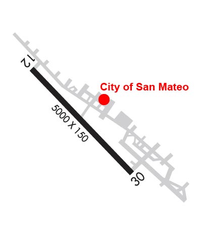
| Lat: N 3730.8 Long: W 12230.1 Elev: 66 Var: -15 Longest Runway: 5000 | ||
| AWOS: 127.27 CTAF: 122.8 | ||
| |||||||||||||||||||||||||||||||||||||||||||||||||||||||||||||
| |||||||||||||||||||||||||||||||||||||||||||||||||||||||||||||
| |||||||||||||||||||||||||||||||||||||||||||||||||||||||||||||
| Rwy | Rwy | |||||||
| 5000x150 | 4248' | 5000x150 | 4238' | |||||
| Runway ID | Single Wheel | Double Wheel | Double Tandem Wheel | Dual Double Wheel |
| 12/30 | 30,000 | 200,000 | 360,000 | N/A |
| These numbers are Advisory and are not limits. The Airport Manager should have more accurate Weight Limits | ||||
 Airport Diagram might not be current. | |
| Facility Name: | HALF MOON BAY |
| City Name: | HALF MOON BAY |
| County: | SAN MATEO |
| State abbrev: | CA |
| State Name: | CALIFORNIA |
| Ownership: | PUBLICLY OWNED |
| Use: | OPEN TO THE PUBLIC |
| Owner's Name: | SAN MATEO COUNTY |
| Address: | 555 COUNTY CENTER, 5TH FLOOR |
| REDWOOD CITY, CA 94063-1665 | |
| Owner's Phone: | 650-573-3700; DIRECTOR OF PUBLIC WORKS: JAMES C. PORTER |
| Manager's Name: | GRETCHEN KELLY; MANAGER LOCATED AT SAN CARLOS AIRPORT. |
| Address: | 620 AIRPORT DRIVE |
| SAN CARLOS, CA 94070 | |
| Phone: | 650-573-3700; MANAGERS OFFICE AIRPORT PHONE 650-573-3701. |
| FAA Region: | WESTERN-PACIFIC |
| FAA Field Office: | SFO |
| Date | Sunrise | Sunset |
|---|---|---|
| 09/24/21 Friday | 6:59 | 19:04 |
| 09/25/21 Saturday | 7:00 | 19:03 |
| 09/26/21 Sunday | 7:01 | 19:01 |
| 09/27/21 Monday | 7:02 | 18:59 |
| 09/28/21 Tuesday | 7:03 | 18:58 |
| 09/29/21 Wednesday | 7:04 | 18:56 |
| 09/30/21 Thursday | 7:04 | 18:55 |
| 10/01/21 Friday | 7:05 | 18:53 |
| 10/02/21 Saturday | 7:06 | 18:52 |
| 10/03/21 Sunday | 7:07 | 18:50 |
| 10/04/21 Monday | 7:08 | 18:49 |
| 10/05/21 Tuesday | 7:09 | 18:47 |
| 10/06/21 Wednesday | 7:10 | 18:46 |
| 10/07/21 Thursday | 7:11 | 18:44 |
| Airport Attendance Schedule | 7 Days A Week 0830-1630 |
| Airport Status | OPERATIONAL (This Status can change at any time - please check NOTAMS) |
| Airport Lighting Schedule | ACTVT MIRL RY 12/30, REIL RY 30, PAPI RYS 12 AND 30 - 122.8. |
| Airport Storage Available | Tie Downs |
| Extra Services Available | NONE |
| Wind Indicator | YES - (lighted) |
| Control Tower | NO |
| CTAF Frequency | 122.800 |
| Unicom Frequency | 122.800 |
| Rotating Beacon Color | CLEAR-GREEN (Light Land Airport) |
| Segmented Circle | YES |
| Landing Fee | NO |
| Airport Inspected | STATE - performed by STATE AERONAUTICAL PERSONNEL |
| Inspection Date | 01/15/2020 |
| Type of Fuel Available | Grade 100LL; -10FUEL AVBL 24 HRS SELF SERVICE. |
| Airframe Repair Service | MINOR |
| Power Plant Repair Service | MINOR |
| Latitude | N3730.8 |
| Longitude | W12230.1 (ESTIMATED) |
| Arpt Elevation | 66ft (SURVEYED) |
| Magnetic Variation | 15E |
| 5 miles NW | of HALF MOON BAY |
| Traffic Pattern Altitude | 933 |
| Sectional Chart | SAN FRANCISCO |
| Operations (Reported) | Yearly | Avg. Daily |
|---|---|---|
| General Aviation Transient | 25000 | 68 |
| General Aviation Local | 25000 | 68 |
| Air Taxi | 150 | 0 |
| Commerical | 0 | 0 |
| Commuter | 0 | 0 |
| Military | 0 | 0 |
| Aircraft based on Field | |
|---|---|
| General Aviation Singles | 12 |
| General Aviation Multi | 1 |
| Jet Aircraft | 0 |
| General Aviation Helicopters | 0 |
| Military Aircraft | 0 |
| Gliders | 0 |
| Ultralights | 0 |
| FSS on field | NO |
| FSS tie-in | OAKLAND |
| FSS Phone | 1-800-WX-BRIEF |
| Who issues Notams | OAK |
| Notam D service at airport | YES |
| ARTCC Name | OAKLAND |
| Airport Certification | |
| Aircraft Rescue & Firefighting Index | None |
| Airport of Entry | No |
| Custom Landing Rights | No |
| Joint Civil/Military | No |
| Military Landing rights | YES |
| NATIONAL PLAN OF INTEGRATED AIRPORT SYSTEMS (NPIAS) |
| GRANT AGREEMENTS UNDER FAAP/ADAP/AIP |
| SURPLUS PROPERTY AGREEMENT UNDER REGULATION 16-WAA |
| ASSURANCES PURSUANT TO TITLE VI, CIVIL RIGHTS ACT OF 1964 |
| THIS AIRPORT HAS BEEN SURVEYED BY THE NATIONAL GEODETIC SURVEY. |
| FLD CONDS-RWY, TWY & APRON GOOD. |
| AVOID FLYING DIRECTLY OVER THE PILLAR POINT AIR FORCE STATION. |
| ARPT NOISE SENSITIVE AREAS NW THRU NE. |
| TWYS, APRONS AND TIEDOWNS: 12,500 LBS MAXIMUM. |
| FOR CD CTC NORCAL APCH AT 916-361-0519. |
| UNEXPECTED TURBULENT CONDS MAY BE ENCTRD WHILE ON FNA TO RWY 12. |
Airport Communications & Frequencies:
| ||||||||||||||
| Runway: 12 | Runway: 30 | ||
| Mag heading: | 122° | Mag heading: | 302° |
| Rwy Slope: | -.68% Down | Rwy Slope: | .68% Up |
| Approach: | Approach: | ||
| Pattern: | Left Traffic | Pattern: | Right Traffic |
| Markings: | NONPRECISION INSTRUMENT | Markings: | NONPRECISION INSTRUMENT |
| Marking Condition: | GOOD | Marking Condition: | GOOD |
| Arresting Dev: | Arresting Dev: | ||
| Lat & Long: | N3731.1 W12230.4 | Lat. & Long.: | N3730.5 W12229.7 |
| Elev: | 66.3 ft. MSL | Elev: | 32.5 ft. MSL |
| TCH: | 24 ft. AGL | TCH: | 24 ft. AGL |
| Visual Glide Path: | 3.00 degrees | Visual Glide Path: | 3.00 degrees |
| Displaced Threshold: | 752 feet | Displaced Threshold: | 762 feet |
| Touchdown Zone: | YES | Touchdown Zone: | YES |
| Touchdown Elev.: | 58.8 feet | Touchdown Elev.: | 53.7 feet |
| Visual Glide Slope: | 2-Light PAPI on LEFT side of Runway | Visual Glide Slope: | 2-Light PAPI on LEFT side of Runway |
| RVR Equipment: | RVR Equipment: | ||
| RVV Equipment: | NO | RVV Equipment: | NO |
| Approach Lights: | Approach Lights: | ||
| REIL: | NO | REIL: | YES |
| Centerline Lights: | NO | Centerline Lights: | NO |
| Touchdown lights: | NO | Touchdown lights: | NO |
| Runway Category: | Runway with a Non-precision Approach | Runway Category: | Runway with a Non-precision Approach |
| Declared Distances: | Declared Distances: | ||
| Obstructions: | TREES | Obstructions: | TREES |
| Marked: | NOT Marked/Lighted | Marked: | NOT Marked/Lighted |
| Clearance slope: | 17:1; APCH RATIO TO DSPLCD THR 50:1. | Clearance slope: | 32:1; APCH RATIO TO DSPLCD THR 50:1. |
| Obstruction height: | 70 feet AGL | Obstruction height: | 70 feet AGL |
| Dist. from runway: | 1390 feet | Dist. from runway: | 2478 feet |
| Centerline offset: | 270 right of centerline | Centerline offset: | 180 feet right of centerline |
| Comments: | Comments: |
Thanks for using FltPlan.com
all rights reserved © 1999-2021 by Flight Plan LLC