
| BOWLING GREEN MUNI BOWLING GREEN MO |
| |
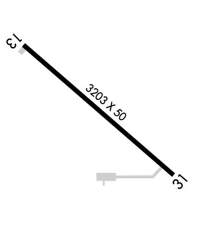
| Lat: N 3922.2 Long: W 09113.2 Elev: 886 Var: -01 Longest Runway: 3203 | ||
| CTAF: 122.8 | ||
| ||||||||||||||||||||||||||||||||||||||||||||
| ||||||||||||||||||||||||||||||||||||||||||||
| Rwy | Rwy | |||||||
| 3203x50 | 3203' | 3203x50 | 3203' | |||||
| Runway ID | Single Wheel | Double Wheel | Double Tandem Wheel | Dual Double Wheel |
| 13/31 | 12,500 | N/A | N/A | N/A |
| These numbers are Advisory and are not limits. The Airport Manager should have more accurate Weight Limits | ||||
 Airport Diagram might not be current. | |
| Facility Name: | BOWLING GREEN MUNI |
| City Name: | BOWLING GREEN |
| County: | PIKE |
| State abbrev: | MO |
| State Name: | MISSOURI |
| Ownership: | PUBLICLY OWNED |
| Use: | OPEN TO THE PUBLIC |
| Owner's Name: | CITY OF BOWLING GREEN |
| Address: | 16 W CHURCH ST |
| BOWLING GREEN, MO 63334 | |
| Owner's Phone: | 573-324-5451 |
| Manager's Name: | JAKE MCDONALD; EMAIL: IAMJAKEMCDONALD@GMAIL.COM. |
| Address: | 16 W CHURCH ST |
| BOWLING GREEN, MO 63334 | |
| Phone: | (573) 213-2174; AIRPORT PHONE (830) 423-2169 |
| FAA Region: | CENTRAL |
| FAA Field Office: | NONE |
| Date | Sunrise | Sunset |
|---|---|---|
| 09/24/21 Friday | 6:54 | 18:59 |
| 09/25/21 Saturday | 6:55 | 18:57 |
| 09/26/21 Sunday | 6:56 | 18:56 |
| 09/27/21 Monday | 6:57 | 18:54 |
| 09/28/21 Tuesday | 6:58 | 18:53 |
| 09/29/21 Wednesday | 6:59 | 18:51 |
| 09/30/21 Thursday | 7:00 | 18:49 |
| 10/01/21 Friday | 7:01 | 18:48 |
| 10/02/21 Saturday | 7:02 | 18:46 |
| 10/03/21 Sunday | 7:03 | 18:45 |
| 10/04/21 Monday | 7:04 | 18:43 |
| 10/05/21 Tuesday | 7:05 | 18:41 |
| 10/06/21 Wednesday | 7:06 | 18:40 |
| 10/07/21 Thursday | 7:07 | 18:38 |
| Airport Attendance Schedule | CONTINUOUS |
| Airport Status | OPERATIONAL (This Status can change at any time - please check NOTAMS) |
| Airport Lighting Schedule | DUSK-DAWN. ACTVT LIRL RWY 13/31 AFT 2100 - CTAF. REIL RWYS 13 AND 31; PAPI RWYS 13 AND 31 - CTAF. |
| Airport Storage Available | Tie Downs |
| Extra Services Available | NONE |
| Wind Indicator | YES - (lighted) |
| Control Tower | NO |
| CTAF Frequency | 122.800 |
| Unicom Frequency | 122.800; UNICOM IREG MNTD. |
| Rotating Beacon Color | CLEAR-GREEN (Light Land Airport) |
| Segmented Circle | YES |
| Landing Fee | NO |
| Airport Inspected | STATE - performed by STATE AERONAUTICAL PERSONNEL |
| Inspection Date | 06/25/2018 |
| Type of Fuel Available | Grade 100LL |
| Airframe Repair Service | None |
| Power Plant Repair Service | None |
| Latitude | N3922.2 |
| Longitude | W09113.2 (ESTIMATED) |
| Arpt Elevation | 886ft (SURVEYED) |
| Magnetic Variation | 01E |
| 2 miles NW | of BOWLING GREEN |
| Traffic Pattern Altitude | |
| Sectional Chart | KANSAS CITY |
| Operations (Reported) | Yearly | Avg. Daily |
|---|---|---|
| General Aviation Transient | 500 | 1 |
| General Aviation Local | 1925 | 5 |
| Air Taxi | 50 | 0 |
| Commerical | 0 | 0 |
| Commuter | 0 | 0 |
| Military | 60 | 0 |
| Aircraft based on Field | |
|---|---|
| General Aviation Singles | 8 |
| General Aviation Multi | 1 |
| Jet Aircraft | 0 |
| General Aviation Helicopters | 0 |
| Military Aircraft | 0 |
| Gliders | 0 |
| Ultralights | 0 |
| FSS on field | NO |
| FSS tie-in | SAINT LOUIS |
| FSS Phone | 1-800-WX-BRIEF |
| Who issues Notams | STL |
| Notam D service at airport | YES |
| ARTCC Name | KANSAS CITY |
| Airport Certification | |
| Aircraft Rescue & Firefighting Index | None |
| Airport of Entry | No |
| Custom Landing Rights | No |
| Joint Civil/Military | No |
| Military Landing rights | YES |
| NATIONAL PLAN OF INTEGRATED AIRPORT SYSTEMS (NPIAS) |
| ASSURANCES PURSUANT TO TITLE VI, CIVIL RIGHTS ACT OF 1964 |
| GRANT AGREEMENT HAS EXPIRED; HOWEVER, AGREEMENT REMAINS IN EFFECT FOR THIS FACILITY AS LONG AS IT IS PUBLIC USE. |
| DO NOT OVERFLY PRISON AREA. |
| FOR CD CTC KANSAS CITY ARTCC AT 913-254-8508. |
| RWY 13/3 1 RWY 13/31 NSTD LIRL; INCORRECT NUMBER OF THLD LGTS AT EACH RWY END, AMBER/WHITE SPLIT LENS MISSING LAST 1602 FT OF EACH RWY. |
Airport Communications & Frequencies:
| |||||||||
| Runway: 13 | Runway: 31 | ||
| Mag heading: | 133° | Mag heading: | 313° |
| Rwy Slope: | .42% Up | Rwy Slope: | -.42% Down |
| Approach: | Approach: | ||
| Pattern: | Left Traffic | Pattern: | Left Traffic |
| Markings: | NONPRECISION INSTRUMENT | Markings: | NONPRECISION INSTRUMENT |
| Marking Condition: | GOOD | Marking Condition: | GOOD |
| Arresting Dev: | Arresting Dev: | ||
| Lat & Long: | N3922.4 W09113.4 | Lat. & Long.: | N3922.0 W09112.9 |
| Elev: | 872.5 ft. MSL | Elev: | 886.0 ft. MSL |
| TCH: | 43 ft. AGL | TCH: | 45 ft. AGL |
| Visual Glide Path: | 3.00 degrees | Visual Glide Path: | 3.00 degrees |
| Displaced Threshold: | No | Displaced Threshold: | No |
| Touchdown Zone: | YES | Touchdown Zone: | YES |
| Touchdown Elev.: | 885.8 feet | Touchdown Elev.: | 886.0 feet |
| Visual Glide Slope: | 2-Light PAPI on LEFT side of Runway | Visual Glide Slope: | 2-Light PAPI on LEFT side of Runway |
| RVR Equipment: | RVR Equipment: | ||
| RVV Equipment: | NO | RVV Equipment: | NO |
| Approach Lights: | Approach Lights: | ||
| REIL: | YES | REIL: | YES |
| Centerline Lights: | NO | Centerline Lights: | NO |
| Touchdown lights: | NO | Touchdown lights: | NO |
| Runway Category: | Runway with a Non-precision Approach | Runway Category: | Runway with a Non-precision Approach |
| Declared Distances: | Declared Distances: | ||
| Obstructions: | TREES | Obstructions: | TREES |
| Marked: | NOT Marked/Lighted | Marked: | NOT Marked/Lighted |
| Clearance slope: | 5:1 | Clearance slope: | 1:1 |
| Obstruction height: | 39 feet AGL | Obstruction height: | 30 feet AGL |
| Dist. from runway: | 423 feet | Dist. from runway: | 250 feet |
| Centerline offset: | 158 right of centerline | Centerline offset: | 130 feet left of centerline |
| Comments: | Comments: | RWY 31 +1-3 FT HI GND; 0-200 FT FROM RWY END 35-250 FT LEFT; +1-4 FT HIGH GND, 0-100 FT FM RWY END, 78-250 FT L. ROAD 184 FT FROM RY END, 175 FT L. |
Thanks for using FltPlan.com
all rights reserved © 1999-2021 by Flight Plan LLC
