
| ABERNATHY FIELD PULASKI TN |
| |
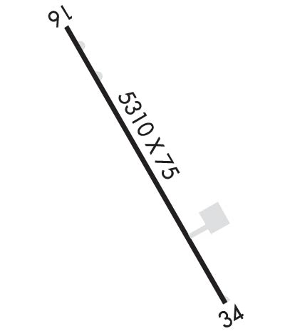
| Lat: N 3509.2 Long: W 08703.4 Elev: 689 Var: +02 Longest Runway: 5310 | ||
| AWOS: 118.27 CTAF: 122.8 | ||
| ||||||
| ||||||
|
| Rwy | Rwy | |||||||
| 5310x75 | 5310' | 5310x75 | 5010' | |||||
| Runway ID | Single Wheel | Double Wheel | Double Tandem Wheel | Dual Double Wheel |
| 16/34 | 54,000 | 75,000 | N/A | N/A |
| These numbers are Advisory and are not limits. The Airport Manager should have more accurate Weight Limits | ||||
 Airport Diagram might not be current. | |
| Facility Name: | ABERNATHY FLD |
| City Name: | PULASKI |
| County: | GILES |
| State abbrev: | TN |
| State Name: | TENNESSEE |
| Ownership: | PUBLICLY OWNED |
| Use: | OPEN TO THE PUBLIC |
| Owner's Name: | CITY OF PULASKI & GILES COUNTY |
| Address: | SOUTH FIRST ST PO BOX 633 |
| PULASKI, TN 38478 | |
| Owner's Phone: | 931-363-2516 |
| Manager's Name: | RANDY JONES |
| Address: | 1736 BETHEL RD |
| PULASKI, TN 38478 | |
| Phone: | 931-363-6827 |
| FAA Region: | SOUTHERN |
| FAA Field Office: | MEM |
| Date | Sunrise | Sunset |
|---|---|---|
| 09/24/21 Friday | 6:37 | 18:42 |
| 09/25/21 Saturday | 6:38 | 18:41 |
| 09/26/21 Sunday | 6:39 | 18:40 |
| 09/27/21 Monday | 6:40 | 18:38 |
| 09/28/21 Tuesday | 6:41 | 18:37 |
| 09/29/21 Wednesday | 6:41 | 18:35 |
| 09/30/21 Thursday | 6:42 | 18:34 |
| 10/01/21 Friday | 6:43 | 18:32 |
| 10/02/21 Saturday | 6:44 | 18:31 |
| 10/03/21 Sunday | 6:44 | 18:30 |
| 10/04/21 Monday | 6:45 | 18:28 |
| 10/05/21 Tuesday | 6:46 | 18:27 |
| 10/06/21 Wednesday | 6:47 | 18:25 |
| 10/07/21 Thursday | 6:48 | 18:24 |
| Airport Attendance Schedule | MON-SAT 0800-1900, SUN 1300-1800; CLSD CHRISTMAS. |
| Airport Status | OPERATIONAL (This Status can change at any time - please check NOTAMS) |
| Airport Lighting Schedule | SS-SR |
| Airport Storage Available | Tie Downs |
| Extra Services Available | Flight Instruction, Aircraft Rental |
| Wind Indicator | YES - (lighted) |
| Control Tower | NO |
| CTAF Frequency | 122.800 |
| Unicom Frequency | 122.800 |
| Rotating Beacon Color | CLEAR-GREEN (Light Land Airport) |
| Segmented Circle | YES |
| Landing Fee | NO |
| Airport Inspected | STATE - performed by STATE AERONAUTICAL PERSONNEL |
| Inspection Date | 06/27/2019 |
| Type of Fuel Available | Grade 100LL, JET A |
| Airframe Repair Service | MAJOR |
| Power Plant Repair Service | MAJOR |
| Latitude | N3509.2 |
| Longitude | W08703.4 (ESTIMATED) |
| Arpt Elevation | 688ft (SURVEYED) |
| Magnetic Variation | 02W |
| 3 miles SW | of PULASKI |
| Traffic Pattern Altitude | |
| Sectional Chart | ATLANTA |
| Operations (Reported) | Yearly | Avg. Daily |
|---|---|---|
| General Aviation Transient | 4180 | 11 |
| General Aviation Local | 3650 | 10 |
| Air Taxi | 650 | 2 |
| Commerical | 0 | 0 |
| Commuter | 0 | 0 |
| Military | 150 | 0 |
| Aircraft based on Field | |
|---|---|
| General Aviation Singles | 12 |
| General Aviation Multi | 6 |
| Jet Aircraft | 1 |
| General Aviation Helicopters | 0 |
| Military Aircraft | 0 |
| Gliders | 0 |
| Ultralights | 0 |
| FSS on field | NO |
| FSS tie-in | JACKSON |
| FSS Phone | 1-800-WX-BRIEF |
| Who issues Notams | MKL |
| Notam D service at airport | YES |
| ARTCC Name | MEMPHIS |
| Airport Certification | |
| Aircraft Rescue & Firefighting Index | None |
| Airport of Entry | No |
| Custom Landing Rights | No |
| Joint Civil/Military | No |
| Military Landing rights | YES |
| NATIONAL PLAN OF INTEGRATED AIRPORT SYSTEMS (NPIAS) |
| GRANT AGREEMENTS UNDER FAAP/ADAP/AIP |
| ASSURANCES PURSUANT TO TITLE VI, CIVIL RIGHTS ACT OF 1964 |
| THIS AIRPORT HAS BEEN SURVEYED BY THE NATIONAL GEODETIC SURVEY. |
| ROCK QUARRY APROX 1000' FM RWY 34, ADV NTC GIVEN TO ARPT WHEN EXPLOSIVES ARE SCHED. |
| FOR CD CTC MEMPHIS ARTCC AT 901-368-8453/8449. |
Airport Communications & Frequencies:
| |||||||||
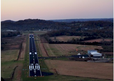
| Runway: 16 | Runway: 34 | ||
| Mag heading: | 155° | Mag heading: | 335° |
| Rwy Slope: | -.82% Down | Rwy Slope: | .82% Up |
| Approach: | Approach: | ||
| Pattern: | Left Traffic | Pattern: | Left Traffic |
| Markings: | NONPRECISION INSTRUMENT | Markings: | NONPRECISION INSTRUMENT |
| Marking Condition: | GOOD | Marking Condition: | GOOD |
| Arresting Dev: | Arresting Dev: | ||
| Lat & Long: | N3509.6 W08703.7 | Lat. & Long.: | N3508.9 W08703.2 |
| Elev: | 688.8 ft. MSL | Elev: | 645.1 ft. MSL |
| TCH: | 23 ft. AGL | TCH: | 28 ft. AGL |
| Visual Glide Path: | 3.80 degrees | Visual Glide Path: | 3.00 degrees |
| Displaced Threshold: | No | Displaced Threshold: | 300 feet |
| Touchdown Zone: | YES | Touchdown Zone: | YES |
| Touchdown Elev.: | 688.8 feet | Touchdown Elev.: | 664.9 feet |
| Visual Glide Slope: | 2-Light PAPI on LEFT side of Runway | Visual Glide Slope: | 2-Light PAPI on LEFT side of Runway |
| RVR Equipment: | RVR Equipment: | ||
| RVV Equipment: | NO | RVV Equipment: | NO |
| Approach Lights: | Approach Lights: | ||
| REIL: | YES | REIL: | YES |
| Centerline Lights: | NO | Centerline Lights: | NO |
| Touchdown lights: | NO | Touchdown lights: | NO |
| Runway Category: | Runway with a Non-precision Approach having visibility minimums greater than 3/4 mile | Runway Category: | Runway with a Non-precision Approach having visibility minimums greater than 3/4 mile |
| Declared Distances: | Declared Distances: | ||
| Obstructions: | TREE | Obstructions: | TREE; ROCK QUARRY MATERIAL HANDLING TOWER. |
| Marked: | NOT Marked/Lighted | Marked: | NOT Marked/Lighted |
| Clearance slope: | 18:1 | Clearance slope: | 44:1; OBSRUCTION CLEARANCE SLOPE ON RY 34 IS 51:1 TO THE DISPLACED THRESHOLD. |
| Obstruction height: | 314 feet AGL | Obstruction height: | 72 feet AGL |
| Dist. from runway: | 6008 feet | Dist. from runway: | 3373 feet |
| Centerline offset: | 438 right of centerline | Centerline offset: | 274 feet right of centerline |
| Comments: | Comments: |
Thanks for using FltPlan.com
all rights reserved © 1999-2021 by Flight Plan LLC