
| GARY/CHICAGO INTL GARY IN |
| |
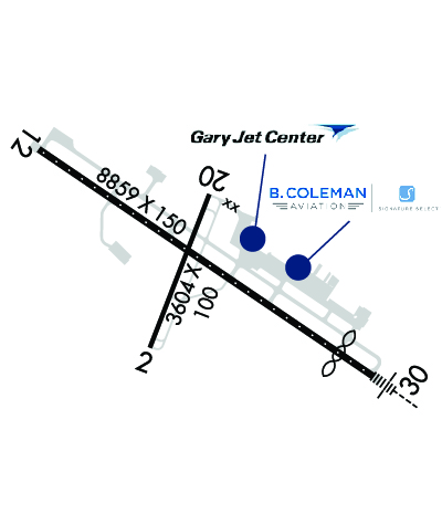
| Lat: N 4137.0 Long: W 08724.9 Elev: 597 Var: +02 Longest Runway: 8859 | ||
| Dept. ATIS: 134.57 Arr. ATIS: 134.57 AWOS: 134.57 Ground: 121.9 Tower: 125.6 | ||
| |||||||||||||||||||||||||||||||||||||||||||||||||||||||||||||||||||||
| |||||||||||||||||||||||||||||||||||||||||||||||||||||||||||||||||||||
| |||||||||||||||||||||||||||||||||||||||||||||||||||||||||||||||||||||
| |||||||||||||||||||||||||||||||||||||||||||||||||||||||||||||||||||||
| Rwy | Rwy | |||||||
| 3604x100 | 3604' | 3604x100 | 3604' | |||||
| 8859x150 | 8859' | 8859x150 | 7959' | 108.75 - 306° | ||||
| Runway ID | Single Wheel | Double Wheel | Double Tandem Wheel | Dual Double Wheel |
| 02/20 | 18,000 | 28,000 | N/A | N/A |
| 12/30 | 75,000 | 157,000 | 175,000 | 250,000 |
| These numbers are Advisory and are not limits. The Airport Manager should have more accurate Weight Limits | ||||
 Airport Diagram might not be current. | |
| Facility Name: | GARY/CHICAGO INTL |
| City Name: | GARY/CHICAGO |
| County: | LAKE |
| State abbrev: | IN |
| State Name: | INDIANA |
| Ownership: | PUBLICLY OWNED |
| Use: | OPEN TO THE PUBLIC |
| Owner's Name: | GARY/CHICAGO ARPT AUTH DIST |
| Address: | 6001 INDUSTRIAL HWY |
| GARY, IN 46406 | |
| Owner's Phone: | 219-949-9722 |
| Manager's Name: | DANIEL VICARI |
| Address: | 6001-C AIRPORT RD |
| GARY, IN 46406 | |
| Phone: | 219-949-4925 |
| FAA Region: | GREAT LAKES |
| FAA Field Office: | CHI |
| Date | Sunrise | Sunset |
|---|---|---|
| 06/08/26 Monday | 5:15 | 20:22 |
| 06/09/26 Tuesday | 5:15 | 20:23 |
| 06/10/26 Wednesday | 5:15 | 20:23 |
| 06/11/26 Thursday | 5:15 | 20:24 |
| 06/12/26 Friday | 5:15 | 20:24 |
| 06/13/26 Saturday | 5:15 | 20:25 |
| 06/14/26 Sunday | 5:15 | 20:25 |
| 06/15/26 Monday | 5:15 | 20:26 |
| 06/16/26 Tuesday | 5:15 | 20:26 |
| 06/17/26 Wednesday | 5:15 | 20:26 |
| 06/18/26 Thursday | 5:15 | 20:27 |
| 06/19/26 Friday | 5:15 | 20:27 |
| 06/20/26 Saturday | 5:15 | 20:27 |
| 06/21/26 Sunday | 5:15 | 20:27 |
| Airport Attendance Schedule | CONTINUOUS |
| Airport Status | OPERATIONAL (This Status can change at any time - please check NOTAMS) |
| Airport Lighting Schedule | WHEN ATCT CLSD ACTVT MALSR RWY 30; REIL RWY 02, 12 & 20; MIRL RWY 02/20; HIRL RWY 12/30 - CTAF. |
| Airport Storage Available | Tie Downs, Hanger |
| Extra Services Available | Cargo Handling, Charter, Flight Instruction, Aircraft Rental |
| Wind Indicator | YES - (lighted) |
| Control Tower | YES |
| CTAF Frequency | 125.600 |
| Unicom Frequency | |
| Rotating Beacon Color | WG |
| Segmented Circle | NO |
| Landing Fee | YES |
| Airport Inspected | FEDERAL - performed by FAA AIRPORTS FIELD PERSONNEL |
| Inspection Date | 11/13/2024 |
| Type of Fuel Available | Grade 100LL, JET A (freeze point -40C) |
| Airframe Repair Service | MAJOR |
| Power Plant Repair Service | MAJOR |
| Latitude | N4137.0 |
| Longitude | W08724.9 (ESTIMATED) |
| Arpt Elevation | 596ft (SURVEYED) |
| Magnetic Variation | 02W |
| 3 miles NW | of GARY/CHICAGO |
| Traffic Pattern Altitude | |
| Sectional Chart | CHICAGO |
| Operations (Reported) | Yearly | Avg. Daily |
|---|---|---|
| General Aviation Transient | 0 | 0 |
| General Aviation Local | 0 | 0 |
| Air Taxi | 0 | 0 |
| Commerical | 0 | 0 |
| Commuter | 0 | 0 |
| Military | 0 | 0 |
| Aircraft based on Field | |
|---|---|
| General Aviation Singles | 0 |
| General Aviation Multi | 0 |
| Jet Aircraft | 0 |
| General Aviation Helicopters | 0 |
| Military Aircraft | 0 |
| Gliders | 0 |
| Ultralights | 0 |
| FSS on field | NO |
| FSS tie-in | TERRE HAUTE |
| FSS Phone | 1-800-WX-BRIEF |
| Who issues Notams | GYY |
| Notam D service at airport | YES |
| ARTCC Name | CHICAGO |
| Airport Certification | CLSD TO SKED ACR OPS GTR THAN 9 PAX SEATS; UNSKED ACR OPS GTR THAN 30 PAX SEATS 1 HR PPR; INDEX B ARFF 1 HR PPR; INDEX C ARFF 4 HR PPR - 219-949-4910. |
| Aircraft Rescue & Firefighting Index | AIRPORT HAS A CERTIFICATE UNDER CFR PART 139 |
| Airport of Entry | No |
| Custom Landing Rights | YES |
| Joint Civil/Military | No |
| Military Landing rights | YES |
| NATIONAL PLAN OF INTEGRATED AIRPORT SYSTEMS (NPIAS) |
| GRANT AGREEMENTS UNDER FAAP/ADAP/AIP |
| CONVEYANCE UNDER SCETION 16, FEDERAL AIRPORT ACT OF 1946 OR SECTION 23, AIRPORT AND AIRWAY DEVELOPMENT ACT OF 1970 |
| ASSURANCES PURSUANT TO TITLE VI, CIVIL RIGHTS ACT OF 1964 |
| BIRDS & WILDLIFE ON & INVOF ARPT. |
| UNCTLD VEHICLES N SIDE RAMPS. |
| TWY A, A1-A8 & C NORTH OF RWY 12/30 AVBL TO ACR MORE THAN 9 PAX SEATS. |
| TWY F MIL USE ONLY. |
| LINE OF SIGHT NA BTN INTERSECTING RWY ENDS. |
| ARNG: OPS 1230Z-2330Z++ TUES-FRI. MIL F/W OR R/W PRKG OR SVC ON ARNG RAMP 24 HR PPR - 219-977-2017. |
| FOR CD WHEN ATCT IS CLSD CTC CHICAGO APCH AT 847-289-0926. |
| RWY 02/2 0 RWY 02/20 NOT AVBL FOR PART 121/PART 380 OPS WITH SKED PAX CARRYING OPS MORE THAN 9 PAX SEATS AND NON-SKED PAX CARRYING OPS MORE THAN 30 PAX SEATS. |
| RWY 02/2 0 PCR VALUE: 121/R/C/X/U |
| RWY 12/3 0 PCR VALUE: 706/R/C/X/U |
Airport Communications & Frequencies:
| |||||||||||||||||||||
| Runway: 02 | Runway: 20 | ||
| Mag heading: | 23° | Mag heading: | 203° |
| Rwy Slope: | .01% Up | Rwy Slope: | -.01% Down |
| Approach: | Approach: | ||
| Pattern: | Left Traffic | Pattern: | Left Traffic |
| Markings: | NONPRECISION INSTRUMENT | Markings: | NONPRECISION INSTRUMENT |
| Marking Condition: | GOOD | Marking Condition: | GOOD |
| Arresting Dev: | Arresting Dev: | ||
| Lat & Long: | N4136.7 W08725.1 | Lat. & Long.: | N4137.3 W08724.8 |
| Elev: | 589.1 ft. MSL | Elev: | 589.3 ft. MSL |
| TCH: | 40 ft. AGL | TCH: | 42 ft. AGL |
| Visual Glide Path: | 3.00 degrees | Visual Glide Path: | 3.00 degrees |
| Displaced Threshold: | No | Displaced Threshold: | No |
| Touchdown Zone: | YES | Touchdown Zone: | YES |
| Touchdown Elev.: | 590.8 feet | Touchdown Elev.: | 590.8 feet |
| Visual Glide Slope: | 2-Light PAPI on LEFT side of Runway | Visual Glide Slope: | 2-Light PAPI on LEFT side of Runway |
| RVR Equipment: | RVR Equipment: | ||
| RVV Equipment: | NO | RVV Equipment: | NO |
| Approach Lights: | Approach Lights: | ||
| REIL: | YES | REIL: | YES |
| Centerline Lights: | NO | Centerline Lights: | NO |
| Touchdown lights: | NO | Touchdown lights: | NO |
| Runway Category: | Runway with a Non-precision Approach | Runway Category: | Runway with a Non-precision Approach |
| Declared Distances: | TORA:3604' TODA:3604' ASDA:3604' LDA:3604' | Declared Distances: | TORA:3604' TODA:3604' ASDA:3604' LDA:3604' |
| Obstructions: | ROAD | Obstructions: | POLE |
| Marked: | NOT Marked/Lighted | Marked: | NOT Marked/Lighted |
| Clearance slope: | 20:1 | Clearance slope: | 17:1 |
| Obstruction height: | 42 feet AGL | Obstruction height: | 37 feet AGL |
| Dist. from runway: | 1050 feet | Dist. from runway: | 833 feet |
| Centerline offset: | Centerline offset: | 289 feet right of centerline | |
| Comments: | Comments: |
| Runway: 12 | Runway: 30 | ||
| Mag heading: | 126° | Mag heading: | 306° |
| Rwy Slope: | -.06% Down | Rwy Slope: | .06% Up |
| Approach: | Approach: | ILS/DME | |
| Pattern: | Left Traffic | Pattern: | Left Traffic |
| Markings: | PRECISION INSTRUMENT | Markings: | PRECISION INSTRUMENT |
| Marking Condition: | GOOD | Marking Condition: | GOOD |
| Arresting Dev: | Arresting Dev: | ||
| Lat & Long: | N4137.5 W08725.6 | Lat. & Long.: | N4136.6 W08724.0 |
| Elev: | 596.8 ft. MSL | Elev: | 591.3 ft. MSL |
| TCH: | 50 ft. AGL | TCH: | 57 ft. AGL |
| Visual Glide Path: | 3.00 degrees | Visual Glide Path: | 3.00 degrees |
| Displaced Threshold: | No | Displaced Threshold: | 900 feet |
| Touchdown Zone: | YES | Touchdown Zone: | YES |
| Touchdown Elev.: | 596.8 feet | Touchdown Elev.: | 591.2 feet |
| Visual Glide Slope: | 4-Light PAPI on LEFT side of Runway | Visual Glide Slope: | 4-Light PAPI on LEFT side of Runway |
| RVR Equipment: | ROLLOUT | RVR Equipment: | TOUCHDOWN |
| RVV Equipment: | NO | RVV Equipment: | NO |
| Approach Lights: | Approach Lights: | MALSR - 1,400 foot medium intensity approach lighting system with runway alignment indicator lights | |
| REIL: | YES | REIL: | NO |
| Centerline Lights: | YES | Centerline Lights: | YES |
| Touchdown lights: | NO | Touchdown lights: | NO |
| Runway Category: | Runway with a Non-precision Approach having visibility minimums greater than 3/4 mile | Runway Category: | Precision Instrument Runway |
| Declared Distances: | TORA:8859' TODA:8859' ASDA:7959' LDA:7959' | Declared Distances: | TORA:8859' TODA:8859' ASDA:8859' LDA:7959' |
| Obstructions: | ANT | Obstructions: | POLE |
| Marked: | NOT Marked/Lighted | Marked: | LIGHTED |
| Clearance slope: | 38:1 | Clearance slope: | 47:1 |
| Obstruction height: | 93 feet AGL | Obstruction height: | 68 feet AGL |
| Dist. from runway: | 3777 feet | Dist. from runway: | 3422 feet |
| Centerline offset: | 1248 left of centerline | Centerline offset: | 220 feet left of centerline |
| Comments: | Comments: |
Thanks for using FltPlan.com
all rights reserved © 1999-2026 by Flight Plan LLC


