
| GLENCOE MUNI GLENCOE MN |
| |
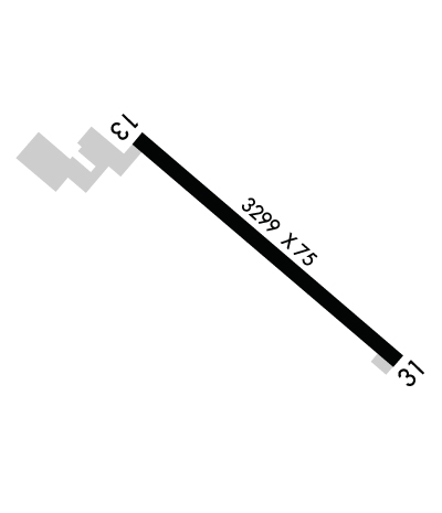
| Lat: N 4445.4 Long: W 09404.9 Elev: 993 Var: -03 Longest Runway: 3300 | ||
| AWOS: 407 CTAF: 122.8 | ||
| ||||||
| ||||||
|
| Rwy | Rwy | |||||||
| 3300x75 | 3300' | 3300x75 | 3300' | |||||
| Runway ID | Single Wheel | Double Wheel | Double Tandem Wheel | Dual Double Wheel |
| 13/31 | N/A | N/A | N/A | N/A |
| These numbers are Advisory and are not limits. The Airport Manager should have more accurate Weight Limits | ||||
 Airport Diagram might not be current. | |
| Facility Name: | GLENCOE MUNI |
| City Name: | GLENCOE |
| County: | MC LEOD |
| State abbrev: | MN |
| State Name: | MINNESOTA |
| Ownership: | PUBLICLY OWNED |
| Use: | OPEN TO THE PUBLIC |
| Owner's Name: | CITY OF GLENCOE |
| Address: | 1107 11TH ST E STE 107 |
| GLENCOE, MN 55336-2327 | |
| Owner's Phone: | 320-864-5586 |
| Manager's Name: | MARK LARSON |
| Address: | 1107 11TH ST E STE 107 |
| GLENCOE, MN 55336-2327 | |
| Phone: | 320-864-5586 |
| FAA Region: | GREAT LAKES |
| FAA Field Office: | DMA |
| Date | Sunrise | Sunset |
|---|---|---|
| 06/08/26 Monday | 5:31 | 21:00 |
| 06/09/26 Tuesday | 5:31 | 21:01 |
| 06/10/26 Wednesday | 5:30 | 21:01 |
| 06/11/26 Thursday | 5:30 | 21:02 |
| 06/12/26 Friday | 5:30 | 21:02 |
| 06/13/26 Saturday | 5:30 | 21:03 |
| 06/14/26 Sunday | 5:30 | 21:03 |
| 06/15/26 Monday | 5:30 | 21:04 |
| 06/16/26 Tuesday | 5:30 | 21:04 |
| 06/17/26 Wednesday | 5:30 | 21:05 |
| 06/18/26 Thursday | 5:30 | 21:05 |
| 06/19/26 Friday | 5:30 | 21:05 |
| 06/20/26 Saturday | 5:30 | 21:05 |
| 06/21/26 Sunday | 5:30 | 21:06 |
| Airport Attendance Schedule | UNATTENDED |
| Airport Status | OPERATIONAL (This Status can change at any time - please check NOTAMS) |
| Airport Lighting Schedule | ACTVT OR INCR INTST REIL RWY 13 & 31; PAPI RWY 13 & 31; MIRL RWY 13/31 - CTAF. MIRL RWY 13/31 PRESET LOW INTST. |
| Airport Storage Available | Tie Downs |
| Extra Services Available | NONE |
| Wind Indicator | YES - (lighted) |
| Control Tower | NO |
| CTAF Frequency | 122.800 |
| Unicom Frequency | 122.800 |
| Rotating Beacon Color | WG |
| Segmented Circle | NO |
| Landing Fee | NO |
| Airport Inspected | STATE - performed by STATE AERONAUTICAL PERSONNEL |
| Inspection Date | 04/11/2024 |
| Type of Fuel Available | Grade 100LL; -10FUEL AVBL H24 VIA CREDIT CARD. |
| Airframe Repair Service | NONE |
| Power Plant Repair Service | NONE |
| Latitude | N4445.4 |
| Longitude | W09404.9 (ESTIMATED) |
| Arpt Elevation | 992ft (SURVEYED) |
| Magnetic Variation | 03E |
| 3 miles SE | of GLENCOE |
| Traffic Pattern Altitude | |
| Sectional Chart | TWIN CITIES |
| Operations (Reported) | Yearly | Avg. Daily |
|---|---|---|
| General Aviation Transient | 0 | 0 |
| General Aviation Local | 0 | 0 |
| Air Taxi | 0 | 0 |
| Commerical | 0 | 0 |
| Commuter | 0 | 0 |
| Military | 0 | 0 |
| Aircraft based on Field | |
|---|---|
| General Aviation Singles | 0 |
| General Aviation Multi | 0 |
| Jet Aircraft | 0 |
| General Aviation Helicopters | 0 |
| Military Aircraft | 0 |
| Gliders | 0 |
| Ultralights | 0 |
| FSS on field | NO |
| FSS tie-in | PRINCETON |
| FSS Phone | 1-800-WX-BRIEF |
| Who issues Notams | GYL |
| Notam D service at airport | YES |
| ARTCC Name | MINNEAPOLIS |
| Airport Certification | |
| Aircraft Rescue & Firefighting Index | None |
| Airport of Entry | No |
| Custom Landing Rights | No |
| Joint Civil/Military | No |
| Military Landing rights | No |
| NATIONAL PLAN OF INTEGRATED AIRPORT SYSTEMS (NPIAS) |
| DEER ON & INVOF ARPT. |
| ULTRALIGHT ACT ON & INVOF ARPT. |
| FOR CD CTC MINNEAPOLIS APCH AT 612-713-4016. |
Airport Communications & Frequencies:
| ||||||||||||||
| Runway: 13 | Runway: 31 | ||
| Mag heading: | 124° | Mag heading: | 304° |
| Rwy Slope: | -.03% Down | Rwy Slope: | .03% Up |
| Approach: | Approach: | ||
| Pattern: | Left Traffic | Pattern: | Left Traffic |
| Markings: | NONPRECISION INSTRUMENT | Markings: | NONPRECISION INSTRUMENT |
| Marking Condition: | GOOD | Marking Condition: | GOOD |
| Arresting Dev: | Arresting Dev: | ||
| Lat & Long: | N4445.5 W09405.2 | Lat. & Long.: | N4445.2 W09404.6 |
| Elev: | 992.4 ft. MSL | Elev: | 991.3 ft. MSL |
| TCH: | 28 ft. AGL | TCH: | 28 ft. AGL |
| Visual Glide Path: | 3.00 degrees | Visual Glide Path: | 3.00 degrees |
| Displaced Threshold: | No | Displaced Threshold: | No |
| Touchdown Zone: | YES | Touchdown Zone: | YES |
| Touchdown Elev.: | 992.5 feet | Touchdown Elev.: | 992.4 feet |
| Visual Glide Slope: | 4-Light PAPI on LEFT side of Runway | Visual Glide Slope: | 4-Light PAPI on LEFT side of Runway |
| RVR Equipment: | RVR Equipment: | ||
| RVV Equipment: | NO | RVV Equipment: | NO |
| Approach Lights: | Approach Lights: | ||
| REIL: | YES | REIL: | YES |
| Centerline Lights: | NO | Centerline Lights: | NO |
| Touchdown lights: | NO | Touchdown lights: | NO |
| Runway Category: | Runway with a Non-precision Approach | Runway Category: | Runway with a Non-precision Approach |
| Declared Distances: | Declared Distances: | ||
| Comments: | 3 FT POLE, 0 FT DIST, 225 FT L. | Comments: |
Thanks for using FltPlan.com
all rights reserved © 1999-2026 by Flight Plan LLC
