
| GWINNER-ROGER MELROE FIELD GWINNER ND |
| |
| Lat: N 4613.1 Long: W 09738.6 Elev: 1266 Var: -04 Longest Runway: 5000 | ||
| AWOS: 118.32 CTAF: 122.7 | ||
| ||||||
| ||||||
|
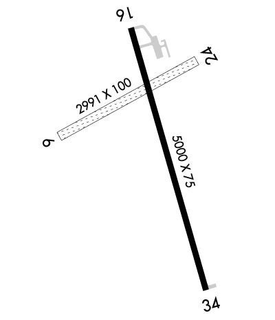
| Rwy | Rwy | |||||||
| 2991x100 | 2991' | 2991x100 | 2991' | |||||
| 5000x75 | 5000' | 5000x75 | 5000' | |||||
| Runway ID | Single Wheel | Double Wheel | Double Tandem Wheel | Dual Double Wheel |
| 06/24 | N/A | N/A | N/A | N/A |
| 16/34 | 14,000 | 19,000 | N/A | N/A |
| These numbers are Advisory and are not limits. The Airport Manager should have more accurate Weight Limits | ||||
 Airport Diagram might not be current. | |
| Facility Name: | GWINNER/ROGER MELROE FLD |
| City Name: | GWINNER |
| County: | SARGENT |
| State abbrev: | ND |
| State Name: | NORTH DAKOTA |
| Ownership: | PUBLICLY OWNED |
| Use: | OPEN TO THE PUBLIC |
| Owner's Name: | GWINNER ARPT AUTH; ADDITIONAL CONTACT GROVER RIEBE 701-680-0605 |
| Address: | 400 4TH AVE SE |
| GWINNER, ND 58040 | |
| Owner's Phone: | 701-680-8000; APT AUTHORITY CHRMN RICK HOISTAD |
| Manager's Name: | RICK HOISTAD |
| Address: | BOX 221 |
| FORMAN, ND 58032 | |
| Phone: | 701-680-8000 |
| FAA Region: | GREAT LAKES |
| FAA Field Office: | DMA |
| Date | Sunrise | Sunset |
|---|---|---|
| 06/08/26 Monday | 5:39 | 21:20 |
| 06/09/26 Tuesday | 5:39 | 21:21 |
| 06/10/26 Wednesday | 5:39 | 21:21 |
| 06/11/26 Thursday | 5:39 | 21:22 |
| 06/12/26 Friday | 5:38 | 21:22 |
| 06/13/26 Saturday | 5:38 | 21:23 |
| 06/14/26 Sunday | 5:38 | 21:24 |
| 06/15/26 Monday | 5:38 | 21:24 |
| 06/16/26 Tuesday | 5:38 | 21:24 |
| 06/17/26 Wednesday | 5:38 | 21:25 |
| 06/18/26 Thursday | 5:38 | 21:25 |
| 06/19/26 Friday | 5:38 | 21:25 |
| 06/20/26 Saturday | 5:39 | 21:26 |
| 06/21/26 Sunday | 5:39 | 21:26 |
| Airport Attendance Schedule | UNATTENDED |
| Airport Status | OPERATIONAL (This Status can change at any time - please check NOTAMS) |
| Airport Lighting Schedule | ACTVT REIL RY 16/34; PAPI RY 16/34 AND MIRL RY 16/34 - CTAF. |
| Airport Storage Available | Tie Downs, Hanger |
| Extra Services Available | Crop Dusting, Flight Instruction |
| Wind Indicator | YES - (lighted) |
| Control Tower | NO |
| CTAF Frequency | 122.700 |
| Unicom Frequency | 122.700 |
| Rotating Beacon Color | WG |
| Segmented Circle | NO |
| Landing Fee | NO |
| Airport Inspected | STATE - performed by STATE AERONAUTICAL PERSONNEL |
| Inspection Date | 09/07/2023 |
| Type of Fuel Available | Grade 100LL, JET A (freeze point -40C); -10SELF SERVICE FUEL AVAILABLE 24 HRS WITH CREDIT CARD. |
| Airframe Repair Service | NONE |
| Power Plant Repair Service | NONE |
| Latitude | N4613.1 |
| Longitude | W09738.6 (ESTIMATED) |
| Arpt Elevation | 1265ft (SURVEYED) |
| Magnetic Variation | 04E |
| 1 miles SE | of GWINNER |
| Traffic Pattern Altitude | |
| Sectional Chart | TWIN CITIES |
| Operations (Reported) | Yearly | Avg. Daily |
|---|---|---|
| General Aviation Transient | 0 | 0 |
| General Aviation Local | 0 | 0 |
| Air Taxi | 0 | 0 |
| Commerical | 0 | 0 |
| Commuter | 0 | 0 |
| Military | 0 | 0 |
| Aircraft based on Field | |
|---|---|
| General Aviation Singles | 0 |
| General Aviation Multi | 0 |
| Jet Aircraft | 0 |
| General Aviation Helicopters | 0 |
| Military Aircraft | 0 |
| Gliders | 0 |
| Ultralights | 0 |
| FSS on field | NO |
| FSS tie-in | GRAND FORKS |
| FSS Phone | 1-800-WX-BRIEF |
| Who issues Notams | GFK |
| Notam D service at airport | YES |
| ARTCC Name | MINNEAPOLIS |
| Airport Certification | |
| Aircraft Rescue & Firefighting Index | None |
| Airport of Entry | No |
| Custom Landing Rights | No |
| Joint Civil/Military | No |
| Military Landing rights | YES |
| NATIONAL PLAN OF INTEGRATED AIRPORT SYSTEMS (NPIAS) |
| GRANT AGREEMENTS UNDER FAAP/ADAP/AIP |
| ASSURANCES PURSUANT TO TITLE VI, CIVIL RIGHTS ACT OF 1964 |
| RY 06/24 CLSD WINTER MONTHS. |
| CFM WINTER CONDS & RWY 16/34 SN REMOVAL CALL 701-680-8000; 701-308-0169;CITY MAINT 701-680-0081. |
| RY 16 +480 FT LGTD TOWER 17500 FT FM THLD 3000 FT R OF EXTDD CNTRLN. |
| DEER & BIRDS ON & INVOF ARPT. |
| FOR CD CTC MINNEAPOLIS ARTCC AT 651-463-5588. |
Airport Communications & Frequencies:
| |||||||||
| Runway: 06 | Runway: 24 | ||
| Mag heading: | 57° | Mag heading: | 237° |
| Rwy Slope: | -.53% Down | Rwy Slope: | .53% Up |
| Approach: | Approach: | ||
| Pattern: | Left Traffic | Pattern: | Left Traffic |
| Markings: | Markings: | ||
| Marking Condition: | RWY 06/24 NO EDGE MKRS. | Marking Condition: | |
| Arresting Dev: | Arresting Dev: | ||
| Lat & Long: | N4613.1 W09739.0 | Lat. & Long.: | N4613.3 W09738.4 |
| Elev: | 1265.1 ft. MSL | Elev: | 1249.1 ft. MSL |
| TCH: | TCH: | ||
| Visual Glide Path: | Visual Glide Path: | ||
| Displaced Threshold: | No | Displaced Threshold: | No |
| Touchdown Zone: | YES | Touchdown Zone: | YES |
| Touchdown Elev.: | 1265.5 feet | Touchdown Elev.: | 1265.5 feet |
| Visual Glide Slope: | Visual Glide Slope: | ||
| RVR Equipment: | RVR Equipment: | ||
| RVV Equipment: | NO | RVV Equipment: | NO |
| Approach Lights: | Approach Lights: | ||
| REIL: | NO | REIL: | NO |
| Centerline Lights: | NO | Centerline Lights: | NO |
| Touchdown lights: | NO | Touchdown lights: | NO |
| Runway Category: | Runway with a Visual Approach | Runway Category: | Runway with a Visual Approach |
| Declared Distances: | Declared Distances: |
| Runway: 16 | Runway: 34 | ||
| Mag heading: | 160° | Mag heading: | 340° |
| Rwy Slope: | .00% Down | Rwy Slope: | .00% Up |
| Approach: | Approach: | ||
| Pattern: | Left Traffic | Pattern: | Left Traffic |
| Markings: | NONPRECISION INSTRUMENT | Markings: | NONPRECISION INSTRUMENT |
| Marking Condition: | GOOD | Marking Condition: | GOOD |
| Arresting Dev: | Arresting Dev: | ||
| Lat & Long: | N4613.4 W09738.7 | Lat. & Long.: | N4612.6 W09738.4 |
| Elev: | 1255.2 ft. MSL | Elev: | 1255.1 ft. MSL |
| TCH: | 25 ft. AGL | TCH: | 25 ft. AGL |
| Visual Glide Path: | 3.00 degrees | Visual Glide Path: | 3.00 degrees |
| Displaced Threshold: | No | Displaced Threshold: | No |
| Touchdown Zone: | YES | Touchdown Zone: | YES |
| Touchdown Elev.: | 1256.6 feet | Touchdown Elev.: | 1256.5 feet |
| Visual Glide Slope: | 2-Light PAPI on LEFT side of Runway | Visual Glide Slope: | 2-Light PAPI on LEFT side of Runway |
| RVR Equipment: | RVR Equipment: | ||
| RVV Equipment: | NO | RVV Equipment: | NO |
| Approach Lights: | Approach Lights: | ||
| REIL: | YES | REIL: | YES |
| Centerline Lights: | NO | Centerline Lights: | NO |
| Touchdown lights: | NO | Touchdown lights: | NO |
| Runway Category: | Runway with a Non-precision Approach having visibility minimums greater than 3/4 mile | Runway Category: | Runway with a Non-precision Approach having visibility minimums greater than 3/4 mile |
| Declared Distances: | Declared Distances: | ||
| Obstructions: | +42 FT PLINE 2680 FT FM THLD ON CNTRLN APCH RATIO 50:1. | Obstructions: | |
| Marked: | NOT Marked/Lighted | Marked: | |
| Clearance slope: | 34:1 | Clearance slope: | 34:1 |
| Obstruction height: | Obstruction height: | ||
| Dist. from runway: | Dist. from runway: | ||
| Centerline offset: | Centerline offset: | ||
| Comments: | Comments: |
Thanks for using FltPlan.com
all rights reserved © 1999-2026 by Flight Plan LLC
