
| GREENWOOD-LEFLORE GREENWOOD MS |
| |
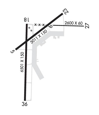
| Lat: N 3329.6 Long: W 09005.2 Elev: 162 Var: +01 Longest Runway: 6501 | ||
| Clr Del: 125.55 AWOS: 119.97 Ground: 125.55 Tower: 118.35 | ||
| ||||||
| ||||||
|
| Rwy | Rwy | |||||||
| 5011x150 | 5011' | 5011x150 | 5011' | |||||
| 6501x150 | 6501' | 111.30 - 182° | 6501x150 | 6501' | ||||
| Runway ID | Single Wheel | Double Wheel | Double Tandem Wheel | Dual Double Wheel |
| 05/23 | 30,000 | N/A | N/A | N/A |
| 18/36 | 100,000 | 176,000 | 300,000 | 560,000 |
| These numbers are Advisory and are not limits. The Airport Manager should have more accurate Weight Limits | ||||
 Airport Diagram might not be current. | |
| Facility Name: | GREENWOOD-LEFLORE |
| City Name: | GREENWOOD |
| County: | CARROLL |
| State abbrev: | MS |
| State Name: | MISSISSIPPI |
| Ownership: | PUBLICLY OWNED |
| Use: | OPEN TO THE PUBLIC |
| Owner's Name: | GREENWOOD CITY & LEFLORE CO |
| Address: | PO BOX 907 |
| GREENWOOD, MS 38930 | |
| Owner's Phone: | 662-453-2246 |
| Manager's Name: | BOBBY NORWOOD |
| Address: | 502-A AIRPORT RD |
| GREENWOOD, MS 38930 | |
| Phone: | 662-453-1526; FBO 662-455-4111/455-3000/455-5700/453-9406/455-1826/453-1080. |
| FAA Region: | SOUTHERN |
| FAA Field Office: | JAN |
| Date | Sunrise | Sunset |
|---|---|---|
| 06/08/26 Monday | 5:50 | 20:09 |
| 06/09/26 Tuesday | 5:50 | 20:09 |
| 06/10/26 Wednesday | 5:50 | 20:10 |
| 06/11/26 Thursday | 5:50 | 20:10 |
| 06/12/26 Friday | 5:50 | 20:11 |
| 06/13/26 Saturday | 5:50 | 20:11 |
| 06/14/26 Sunday | 5:50 | 20:11 |
| 06/15/26 Monday | 5:50 | 20:12 |
| 06/16/26 Tuesday | 5:50 | 20:12 |
| 06/17/26 Wednesday | 5:50 | 20:12 |
| 06/18/26 Thursday | 5:50 | 20:13 |
| 06/19/26 Friday | 5:50 | 20:13 |
| 06/20/26 Saturday | 5:51 | 20:13 |
| 06/21/26 Sunday | 5:51 | 20:13 |
| Airport Attendance Schedule | MON-FRI 0800-1800; CLSD 2 DAYS EACH AT THANKSGIVING & CHRISTMAS, 1 DAY FOR NEW YEAR'S. |
| Airport Status | OPERATIONAL (This Status can change at any time - please check NOTAMS) |
| Airport Lighting Schedule | WHEN TWR CLSD, ACTVT MALSR RWY 18; PAPI RWY 36; MIRL RWY 05/23; HIRL RWY 18/36 - CTAF. VASI RWY 05 OPR CONSLY. |
| Airport Storage Available | Tie Downs |
| Extra Services Available | Crop Dusting, Flight Instruction |
| Wind Indicator | YES - (lighted) |
| Control Tower | YES |
| CTAF Frequency | 118.350 |
| Unicom Frequency | 122.950 |
| Rotating Beacon Color | WG |
| Segmented Circle | YES |
| Landing Fee | NO |
| Airport Inspected | STATE - performed by STATE AERONAUTICAL PERSONNEL |
| Inspection Date | 03/26/2026 |
| Type of Fuel Available | Grade 100LL, JET A (freeze point -40C), JET A-1 (icing inhibitor, freeze point -50C); -10FUEL AVBL MON-FRI 0900-1800, SAT-SUN 1000-1600. FEE FOR FUEL AFT HRS CALL 662-392-3988, 662-392-8899 OR 662-455-5530 FOR SVC AFT HRS. |
| Airframe Repair Service | MAJOR; IN EMERG OR BY APPT. |
| Power Plant Repair Service | MAJOR; IN EMERG OR BY APPT. |
| Latitude | N3329.6 |
| Longitude | W09005.2 (ESTIMATED) |
| Arpt Elevation | 162ft (SURVEYED) |
| Magnetic Variation | 01W |
| 6 miles E | of GREENWOOD |
| Traffic Pattern Altitude | |
| Sectional Chart | MEMPHIS |
| Operations (Reported) | Yearly | Avg. Daily |
|---|---|---|
| General Aviation Transient | 0 | 0 |
| General Aviation Local | 0 | 0 |
| Air Taxi | 0 | 0 |
| Commerical | 0 | 0 |
| Commuter | 0 | 0 |
| Military | 0 | 0 |
| Aircraft based on Field | |
|---|---|
| General Aviation Singles | 0 |
| General Aviation Multi | 0 |
| Jet Aircraft | 0 |
| General Aviation Helicopters | 0 |
| Military Aircraft | 0 |
| Gliders | 0 |
| Ultralights | 0 |
| FSS on field | NO |
| FSS tie-in | GREENWOOD |
| FSS Phone | 1-800-WX-BRIEF |
| Who issues Notams | GWO |
| Notam D service at airport | YES |
| ARTCC Name | MEMPHIS |
| Airport Certification | |
| Aircraft Rescue & Firefighting Index | None |
| Airport of Entry | No |
| Custom Landing Rights | No |
| Joint Civil/Military | No |
| Military Landing rights | YES |
| NATIONAL PLAN OF INTEGRATED AIRPORT SYSTEMS (NPIAS) |
| GRANT AGREEMENTS UNDER FAAP/ADAP/AIP |
| SURPLUS PROPERTY AGREEMENT UNDER PUBLIC LAW 289 |
| ASSURANCES PURSUANT TO TITLE VI, CIVIL RIGHTS ACT OF 1964 |
| AGREEMENT UNDER DLAND OR DCLA HAS EXPIRED. |
| FOR CD CTC MEMPHIS ARTCC AT 901-368-8453/8449. |
| RWY 05/2 3 AMGR LIMITS GWT RWY 05/23 TO S42, D60 IN UNUSUAL SITUATIONS. |
Airport Communications & Frequencies:
| |||||||||||||||||||||||
| Runway: 05 | Runway: 23 | ||
| Mag heading: | 53° | Mag heading: | 233° |
| Rwy Slope: | .28% Up | Rwy Slope: | -.28% Down |
| Approach: | Approach: | ||
| Pattern: | Left Traffic | Pattern: | Left Traffic |
| Markings: | NONPRECISION INSTRUMENT | Markings: | BASIC |
| Marking Condition: | GOOD | Marking Condition: | GOOD |
| Arresting Dev: | Arresting Dev: | ||
| Lat & Long: | N3329.6 W09005.5 | Lat. & Long.: | N3330.1 W09004.7 |
| Elev: | 140.1 ft. MSL | Elev: | 154.2 ft. MSL |
| TCH: | 33 ft. AGL | TCH: | |
| Visual Glide Path: | 3.00 degrees | Visual Glide Path: | |
| Displaced Threshold: | No | Displaced Threshold: | No |
| Touchdown Zone: | YES | Touchdown Zone: | YES |
| Touchdown Elev.: | 148.5 feet | Touchdown Elev.: | 154.5 feet |
| Visual Glide Slope: | 4-BOX VASI ON LEFT SIDE OF RUNWAY | Visual Glide Slope: | PULSATING/STEADY BURNING VASI ON RIGHT SIDE OF RUNWAY |
| RVR Equipment: | RVR Equipment: | ||
| RVV Equipment: | NO | RVV Equipment: | NO |
| Approach Lights: | Approach Lights: | ||
| REIL: | NO | REIL: | YES |
| Centerline Lights: | NO | Centerline Lights: | NO |
| Touchdown lights: | NO | Touchdown lights: | NO |
| Runway Category: | Runway with a Non-precision Approach having visibility minimums greater than 3/4 mile | Runway Category: | Runway with a Visual Approach |
| Declared Distances: | Declared Distances: | ||
| Obstructions: | TREES | Obstructions: | TREES |
| Marked: | NOT Marked/Lighted | Marked: | NOT Marked/Lighted |
| Clearance slope: | 14:1 | Clearance slope: | 15:1 |
| Obstruction height: | 53 feet AGL | Obstruction height: | 60 feet AGL |
| Dist. from runway: | 963 feet | Dist. from runway: | 1100 feet |
| Centerline offset: | 100 left of centerline | Centerline offset: | 200B |
| Comments: | Comments: |
| Runway: 18 | Runway: 36 | ||
| Mag heading: | 182° | Mag heading: | 2° |
| Rwy Slope: | -.09% Down | Rwy Slope: | .09% Up |
| Approach: | ILS | Approach: | |
| Pattern: | Left Traffic | Pattern: | Left Traffic |
| Markings: | PRECISION INSTRUMENT | Markings: | PRECISION INSTRUMENT |
| Marking Condition: | GOOD | Marking Condition: | GOOD |
| Arresting Dev: | Arresting Dev: | ||
| Lat & Long: | N3329.9 W09005.3 | Lat. & Long.: | N3328.9 W09005.3 |
| Elev: | 145.0 ft. MSL | Elev: | 139.0 ft. MSL |
| TCH: | TCH: | 50 ft. AGL | |
| Visual Glide Path: | Visual Glide Path: | 3.00 degrees | |
| Displaced Threshold: | No | Displaced Threshold: | No |
| Touchdown Zone: | YES | Touchdown Zone: | YES |
| Touchdown Elev.: | 145.1 feet | Touchdown Elev.: | 142.2 feet |
| Visual Glide Slope: | Visual Glide Slope: | 4-Light PAPI on LEFT side of Runway | |
| RVR Equipment: | RVR Equipment: | ||
| RVV Equipment: | NO | RVV Equipment: | NO |
| Approach Lights: | MALSR - 1,400 foot medium intensity approach lighting system with runway alignment indicator lights | Approach Lights: | |
| REIL: | NO | REIL: | YES |
| Centerline Lights: | NO | Centerline Lights: | NO |
| Touchdown lights: | NO | Touchdown lights: | NO |
| Runway Category: | Precision Instrument Runway | Runway Category: | Runway with a Non-precision Approach having visibility minimums greater than 3/4 mile |
| Declared Distances: | Declared Distances: |
Thanks for using FltPlan.com
all rights reserved © 1999-2026 by Flight Plan LLC
