| LEE GILMER MEMORIAL GAINESVILLE GA |
| |
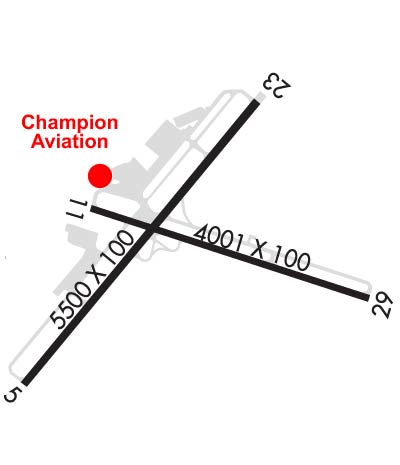
| Lat: N 3416.4 Long: W 08349.8 Elev: 1277 Var: +03 Longest Runway: 5496 | ||
| Clr Del: 121.72 (GCO) AWOS: 126.47 CTAF: 123.07 | ||
| |||||||||||||||||||||||||||||||||||||||||||||||||||||||||||||
| |||||||||||||||||||||||||||||||||||||||||||||||||||||||||||||
| |||||||||||||||||||||||||||||||||||||||||||||||||||||||||||||
| |||||||||||||||||||||||||||||||||||||||||||||||||||||||||||||
| Rwy | Rwy | |||||||
| 5496x100 | 5496' | 110.55 - 044° | 5496x100 | 5100' | ||||
| 4003x100 | 3883' | 4003x100 | 3892' | |||||
| Runway ID | Single Wheel | Double Wheel | Double Tandem Wheel | Dual Double Wheel |
| 05/23 | 45,000 | 100,000 | N/A | N/A |
| 11/29 | 20,000 | 35,000 | N/A | N/A |
| These numbers are Advisory and are not limits. The Airport Manager should have more accurate Weight Limits | ||||
 Airport Diagram might not be current. | |
| Facility Name: | LEE GILMER MEML |
| City Name: | GAINESVILLE |
| County: | HALL |
| State abbrev: | GA |
| State Name: | GEORGIA |
| Ownership: | PUBLICLY OWNED |
| Use: | OPEN TO THE PUBLIC |
| Owner's Name: | CITY OF GAINESVILLE |
| Address: | P.O. BOX 2496 |
| GAINESVILLE, GA 30501 | |
| Owner's Phone: | 770-535-6882 |
| Manager's Name: | LISA POOLE |
| Address: | PO BOX 2496 |
| GAINESVILLE, GA 30503-2496 | |
| Phone: | 770-535-6882 |
| FAA Region: | SOUTHERN |
| FAA Field Office: | ATL |

| Date | Sunrise | Sunset |
|---|---|---|
| 09/24/21 Friday | 7:25 | 19:30 |
| 09/25/21 Saturday | 7:25 | 19:28 |
| 09/26/21 Sunday | 7:26 | 19:27 |
| 09/27/21 Monday | 7:27 | 19:25 |
| 09/28/21 Tuesday | 7:27 | 19:24 |
| 09/29/21 Wednesday | 7:28 | 19:23 |
| 09/30/21 Thursday | 7:29 | 19:21 |
| 10/01/21 Friday | 7:30 | 19:20 |
| 10/02/21 Saturday | 7:30 | 19:18 |
| 10/03/21 Sunday | 7:31 | 19:17 |
| 10/04/21 Monday | 7:32 | 19:16 |
| 10/05/21 Tuesday | 7:33 | 19:14 |
| 10/06/21 Wednesday | 7:33 | 19:13 |
| 10/07/21 Thursday | 7:34 | 19:12 |
| Airport Attendance Schedule | 7 Days A Week DALGT |
| Airport Status | OPERATIONAL (This Status can change at any time - please check NOTAMS) |
| Airport Lighting Schedule | DUSK-DAWN. ACTVT HIRL RY 05/23 AND MALSR RY 05 - CTAF. |
| Airport Storage Available | Tie Downs |
| Extra Services Available | Charter, Flight Instruction, Aircraft Rental, Aircraft Sales |
| Wind Indicator | YES - (lighted) |
| Control Tower | NO |
| CTAF Frequency | 123.075 |
| Unicom Frequency | 123.075 |
| Rotating Beacon Color | CLEAR-GREEN (Light Land Airport) |
| Segmented Circle | YES |
| Landing Fee | NO |
| Airport Inspected | STATE - performed by STATE AERONAUTICAL PERSONNEL |
| Inspection Date | 04/23/2021 |
| Type of Fuel Available | Grade 100LL, JET A; -1024 HOUR SELF SERVICE FUEL WITH CREDIT CARD. |
| Airframe Repair Service | MAJOR |
| Power Plant Repair Service | MINOR |
| Latitude | N3416.4 |
| Longitude | W08349.8 (ESTIMATED) |
| Arpt Elevation | 1276ft (SURVEYED) |
| Magnetic Variation | 03W |
| 0 miles S | of GAINESVILLE |
| Traffic Pattern Altitude | |
| Sectional Chart | ATLANTA |
| Operations (Reported) | Yearly | Avg. Daily |
|---|---|---|
| General Aviation Transient | 18000 | 49 |
| General Aviation Local | 20000 | 55 |
| Air Taxi | 0 | 0 |
| Commerical | 0 | 0 |
| Commuter | 0 | 0 |
| Military | 500 | 1 |
| Aircraft based on Field | |
|---|---|
| General Aviation Singles | 113 |
| General Aviation Multi | 15 |
| Jet Aircraft | 7 |
| General Aviation Helicopters | 0 |
| Military Aircraft | 0 |
| Gliders | 0 |
| Ultralights | 0 |
| FSS on field | NO |
| FSS tie-in | MACON |
| FSS Phone | 1-800-WX-BRIEF |
| Who issues Notams | GVL |
| Notam D service at airport | YES |
| ARTCC Name | ATLANTA |
| Airport Certification | |
| Aircraft Rescue & Firefighting Index | None |
| Airport of Entry | No |
| Custom Landing Rights | No |
| Joint Civil/Military | No |
| Military Landing rights | YES |
| NATIONAL PLAN OF INTEGRATED AIRPORT SYSTEMS (NPIAS) |
| GRANT AGREEMENTS UNDER FAAP/ADAP/AIP |
| SURPLUS PROPERTY AGREEMENT UNDER PUBLIC LAW 289 |
| ASSURANCES PURSUANT TO TITLE VI, CIVIL RIGHTS ACT OF 1964 |
| AGREEMENT UNDER DLAND OR DCLA HAS EXPIRED. |
| DEER ON & INVOF ALL RYS. |
| FOR CD IF UNA TO CTC ON FSS FREQ, CTC ATLANTA APCH AT 678-364-6131, WHEN ATCT CLSD CTC ATLANTA ARTCC AT 770-210-7692. |
Airport Communications & Frequencies:
| |||||||||||||||||||||
| Runway: 05 | Runway: 23 | ||
| Mag heading: | 44° | Mag heading: | 224° |
| Rwy Slope: | -.67% Down | Rwy Slope: | .67% Up |
| Approach: | ILS/DME | Approach: | |
| Pattern: | Left Traffic | Pattern: | Left Traffic |
| Markings: | PRECISION INSTRUMENT | Markings: | PRECISION INSTRUMENT |
| Marking Condition: | GOOD | Marking Condition: | GOOD |
| Arresting Dev: | Arresting Dev: | ||
| Lat & Long: | N3416.0 W08350.3 | Lat. & Long.: | N3416.7 W08349.6 |
| Elev: | 1274.3 ft. MSL | Elev: | 1237.5 ft. MSL |
| TCH: | 30 ft. AGL | TCH: | 38 ft. AGL |
| Visual Glide Path: | 3.00 degrees | Visual Glide Path: | 3.00 degrees |
| Displaced Threshold: | No | Displaced Threshold: | 396 feet |
| Touchdown Zone: | YES | Touchdown Zone: | YES |
| Touchdown Elev.: | 1275.3 feet | Touchdown Elev.: | 1273.8 feet |
| Visual Glide Slope: | 2-Light PAPI on RIGHT side of Runway | Visual Glide Slope: | 2-Light PAPI on LEFT side of Runway; UNUSBL BYD 8 DEG L AND R OF RCL. |
| RVR Equipment: | RVR Equipment: | ||
| RVV Equipment: | NO | RVV Equipment: | NO |
| Approach Lights: | MALSR - 1,400 foot medium intensity approach lighting system with runway alignment indicator lights | Approach Lights: | |
| REIL: | NO | REIL: | NO |
| Centerline Lights: | NO | Centerline Lights: | NO |
| Touchdown lights: | NO | Touchdown lights: | NO |
| Runway Category: | Precision Instrument Runway | Runway Category: | Runway with a Non-precision Approach having visibility minimums greater than 3/4 mile |
| Declared Distances: | TORA:5496' TODA:5496' ASDA:5370' LDA:5370' | Declared Distances: | TORA:5496' TODA:5496' ASDA:5496' LDA:5100' |
| Obstructions: | Obstructions: | TREES | |
| Marked: | Marked: | NOT Marked/Lighted | |
| Clearance slope: | 50:1 | Clearance slope: | 17:1; APCH 50:1 TO DSPLCD THLD |
| Obstruction height: | Obstruction height: | 41 feet AGL | |
| Dist. from runway: | Dist. from runway: | 897 feet | |
| Centerline offset: | Centerline offset: | 500 feet left of centerline | |
| Comments: | Comments: | BUILDING 360' LEFT 0'-80' FROM EOR |
| Runway: 11 | Runway: 29 | ||
| Mag heading: | 111° | Mag heading: | 291° |
| Rwy Slope: | -.32% Down | Rwy Slope: | .32% Up |
| Approach: | Approach: | ||
| Pattern: | Left Traffic | Pattern: | Left Traffic |
| Markings: | BASIC | Markings: | BASIC |
| Marking Condition: | GOOD | Marking Condition: | GOOD |
| Arresting Dev: | Arresting Dev: | ||
| Lat & Long: | N3416.4 W08350.0 | Lat. & Long.: | N3416.2 W08349.3 |
| Elev: | 1272.8 ft. MSL | Elev: | 1259.9 ft. MSL |
| TCH: | TCH: | ||
| Visual Glide Path: | Visual Glide Path: | ||
| Displaced Threshold: | 120 feet | Displaced Threshold: | 111 feet |
| Touchdown Zone: | YES | Touchdown Zone: | YES |
| Touchdown Elev.: | 1276.9 feet | Touchdown Elev.: | 1276.9 feet |
| Visual Glide Slope: | Visual Glide Slope: | ||
| RVR Equipment: | RVR Equipment: | ||
| RVV Equipment: | NO | RVV Equipment: | NO |
| Approach Lights: | Approach Lights: | ||
| REIL: | NO | REIL: | NO |
| Centerline Lights: | NO | Centerline Lights: | NO |
| Touchdown lights: | NO | Touchdown lights: | NO |
| Runway Category: | Runway with a Visual Approach | Runway Category: | Runway with a Visual Approach |
| Declared Distances: | TORA:4001' TODA:4001' ASDA:3881' LDA:3770' | Declared Distances: | TORA:4001' TODA:4001' ASDA:3890' LDA:3770' |
| Obstructions: | TREES | Obstructions: | TREES |
| Marked: | NOT Marked/Lighted | Marked: | NOT Marked/Lighted |
| Clearance slope: | 6:1 | Clearance slope: | 11:1 |
| Obstruction height: | 10 feet AGL | Obstruction height: | 27 feet AGL |
| Dist. from runway: | 260 feet | Dist. from runway: | 497 feet |
| Centerline offset: | 100 left of centerline | Centerline offset: | 138 feet right of centerline |
| Comments: | Comments: |
Thanks for using FltPlan.com
all rights reserved © 1999-2021 by Flight Plan LLC