| GUYMON MUNI GUYMON OK |
| |
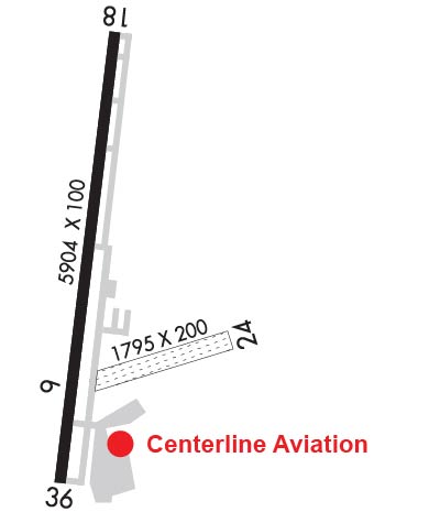
| Lat: N 3641.0 Long: W 10130.4 Elev: 3125 Var: -09 Longest Runway: 5904 | ||
| AWOS: 119.92 CTAF: 122.7 | ||
| |||||||||||||||||||||||||||||||||||||||||||||||||||||||||||||
| |||||||||||||||||||||||||||||||||||||||||||||||||||||||||||||
| |||||||||||||||||||||||||||||||||||||||||||||||||||||||||||||
| Rwy | Rwy | |||||||
| 1795x200 | 1795' | 1795x200 | 1795' | |||||
| 5904x100 | 5904' | 5904x100 | 5904' | |||||
| Runway ID | Single Wheel | Double Wheel | Double Tandem Wheel | Dual Double Wheel |
| 06/24 | N/A | N/A | N/A | N/A |
| 18/36 | 10,000 | N/A | N/A | N/A |
| These numbers are Advisory and are not limits. The Airport Manager should have more accurate Weight Limits | ||||
 Airport Diagram might not be current. | |
| Facility Name: | GUYMON MUNI |
| City Name: | GUYMON |
| County: | TEXAS |
| State abbrev: | OK |
| State Name: | OKLAHOMA |
| Ownership: | PUBLICLY OWNED |
| Use: | OPEN TO THE PUBLIC |
| Owner's Name: | CITY OF GUYMON |
| Address: | 424 N MAIN |
| GUYMON, OK 73942 | |
| Owner's Phone: | 580-338-3396 |
| Manager's Name: | GREGG R DOWNING |
| Address: | PO BOX 1510 |
| GUYMON, OK 73942 | |
| Phone: | 580-338-7700 |
| FAA Region: | SOUTHWEST |
| FAA Field Office: | AOK |
| Date | Sunrise | Sunset |
|---|---|---|
| 06/08/26 Monday | 6:27 | 21:03 |
| 06/09/26 Tuesday | 6:27 | 21:04 |
| 06/10/26 Wednesday | 6:27 | 21:04 |
| 06/11/26 Thursday | 6:27 | 21:05 |
| 06/12/26 Friday | 6:27 | 21:05 |
| 06/13/26 Saturday | 6:27 | 21:06 |
| 06/14/26 Sunday | 6:27 | 21:06 |
| 06/15/26 Monday | 6:27 | 21:06 |
| 06/16/26 Tuesday | 6:27 | 21:07 |
| 06/17/26 Wednesday | 6:27 | 21:07 |
| 06/18/26 Thursday | 6:27 | 21:07 |
| 06/19/26 Friday | 6:27 | 21:08 |
| 06/20/26 Saturday | 6:27 | 21:08 |
| 06/21/26 Sunday | 6:28 | 21:08 |
| Airport Attendance Schedule | MON-SAT 0700-1800, SUN 0800-1700; FOR ATTENDANT AFT HRS CALL 580-338-0481/7700. |
| Airport Status | OPERATIONAL (This Status can change at any time - please check NOTAMS) |
| Airport Lighting Schedule | ACTVT ODALS RWY 18; VASI RWY 18; PAPI RWY 36; MIRL RWY 18/36 - CTAF. MIRL RWY 18/36 PRESET LOW INTST, INCR INTST - CTAF. |
| Airport Storage Available | Tie Downs, Hanger |
| Extra Services Available | Crop Dusting, Air Ambulance, Cargo Handling, Flight Instruction, Aircraft Rental |
| Wind Indicator | YES - (lighted) |
| Control Tower | NO |
| CTAF Frequency | 122.700 |
| Unicom Frequency | 122.700 |
| Rotating Beacon Color | WG |
| Segmented Circle | YES |
| Landing Fee | NO |
| Airport Inspected | STATE - performed by STATE AERONAUTICAL PERSONNEL |
| Inspection Date | 09/03/2025 |
| Type of Fuel Available | Grade 100LL, JET A |
| Airframe Repair Service | MAJOR |
| Power Plant Repair Service | MAJOR |
| Latitude | N3641.0 |
| Longitude | W10130.4 (ESTIMATED) |
| Arpt Elevation | 3125ft (SURVEYED) |
| Magnetic Variation | 09E |
| 1 miles W | of GUYMON |
| Traffic Pattern Altitude | |
| Sectional Chart | WICHITA |
| Operations (Reported) | Yearly | Avg. Daily |
|---|---|---|
| General Aviation Transient | 0 | 0 |
| General Aviation Local | 0 | 0 |
| Air Taxi | 0 | 0 |
| Commerical | 0 | 0 |
| Commuter | 0 | 0 |
| Military | 0 | 0 |
| Aircraft based on Field | |
|---|---|
| General Aviation Singles | 0 |
| General Aviation Multi | 0 |
| Jet Aircraft | 0 |
| General Aviation Helicopters | 0 |
| Military Aircraft | 0 |
| Gliders | 0 |
| Ultralights | 0 |
| FSS on field | NO |
| FSS tie-in | MC ALESTER |
| FSS Phone | 1-800-WX-BRIEF |
| Who issues Notams | GUY |
| Notam D service at airport | YES |
| ARTCC Name | KANSAS CITY |
| Airport Certification | |
| Aircraft Rescue & Firefighting Index | None |
| Airport of Entry | No |
| Custom Landing Rights | No |
| Joint Civil/Military | No |
| Military Landing rights | YES |
| NATIONAL PLAN OF INTEGRATED AIRPORT SYSTEMS (NPIAS) |
| GRANT AGREEMENTS UNDER FAAP/ADAP/AIP |
| ASSURANCES PURSUANT TO TITLE VI, CIVIL RIGHTS ACT OF 1964 |
| ARPT COURTESY CAR AVBL. |
| NUMEROUS WATERFOWL INVOF ARPT SR & SS. |
| FOR CD CTC KANSAS CITY ARTCC AT 913-254-8508. |
| RWY 06/2 4 RWY 06 DEP NA. |
| RWY 18/3 6 PCR VALUE: 130/F/D/X/T |
Airport Communications & Frequencies:
| |||||||||
| Runway: 06 | Runway: 24 | ||
| Mag heading: | 65° | Mag heading: | 245° |
| Rwy Slope: | -1.28% Down | Rwy Slope: | 1.28% Up |
| Approach: | Approach: | ||
| Pattern: | Left Traffic | Pattern: | Left Traffic |
| Markings: | NONE | Markings: | NONE |
| Marking Condition: | FAIR; EDGES MARKED W/ RAISED WOODEN MRKRS. | Marking Condition: | FAIR |
| Arresting Dev: | Arresting Dev: | ||
| Lat & Long: | N3640.8 W10130.4 | Lat. & Long.: | N3640.9 W10130.1 |
| Elev: | 3115.0 ft. MSL | Elev: | 3092.0 ft. MSL |
| TCH: | TCH: | ||
| Visual Glide Path: | Visual Glide Path: | ||
| Displaced Threshold: | No | Displaced Threshold: | No |
| Touchdown Zone: | YES | Touchdown Zone: | YES |
| Touchdown Elev.: | 3115.0 feet | Touchdown Elev.: | 3115.0 feet |
| Visual Glide Slope: | Visual Glide Slope: | ||
| RVR Equipment: | RVR Equipment: | ||
| RVV Equipment: | NO | RVV Equipment: | NO |
| Approach Lights: | Approach Lights: | ||
| REIL: | NO | REIL: | NO |
| Centerline Lights: | NO | Centerline Lights: | NO |
| Touchdown lights: | NO | Touchdown lights: | NO |
| Runway Category: | Runway with a Visual Approach | Runway Category: | Runway with a Visual Approach |
| Declared Distances: | Declared Distances: |
| Runway: 18 | Runway: 36 | ||
| Mag heading: | 177° | Mag heading: | 357° |
| Rwy Slope: | .11% Up | Rwy Slope: | -.11% Down |
| Approach: | Approach: | ||
| Pattern: | Right Traffic | Pattern: | Left Traffic |
| Markings: | NONPRECISION INSTRUMENT | Markings: | NONPRECISION INSTRUMENT |
| Marking Condition: | GOOD | Marking Condition: | GOOD |
| Arresting Dev: | Arresting Dev: | ||
| Lat & Long: | N3641.6 W10130.4 | Lat. & Long.: | N3640.6 W10130.5 |
| Elev: | 3102.8 ft. MSL | Elev: | 3109.4 ft. MSL |
| TCH: | 25 ft. AGL | TCH: | 35 ft. AGL |
| Visual Glide Path: | 3.00 degrees | Visual Glide Path: | 3.00 degrees |
| Displaced Threshold: | No | Displaced Threshold: | No |
| Touchdown Zone: | YES | Touchdown Zone: | YES |
| Touchdown Elev.: | 3124.8 feet | Touchdown Elev.: | 3125.4 feet |
| Visual Glide Slope: | 4-BOX VASI ON LEFT SIDE OF RUNWAY | Visual Glide Slope: | 4-Light PAPI on LEFT side of Runway |
| RVR Equipment: | RVR Equipment: | ||
| RVV Equipment: | NO | RVV Equipment: | NO |
| Approach Lights: | ODALS - omnidirectional approach lighting system | Approach Lights: | |
| REIL: | NO | REIL: | NO |
| Centerline Lights: | NO | Centerline Lights: | NO |
| Touchdown lights: | NO | Touchdown lights: | NO |
| Runway Category: | Runway with a Non-precision Approach having visibility minimums greater than 3/4 mile | Runway Category: | Runway with a Non-precision Approach having visibility minimums greater than 3/4 mile |
| Declared Distances: | Declared Distances: | ||
| Obstructions: | Obstructions: | TREE | |
| Marked: | Marked: | NOT Marked/Lighted | |
| Clearance slope: | 34:1 | Clearance slope: | 8:1 |
| Obstruction height: | Obstruction height: | 19 feet AGL | |
| Dist. from runway: | Dist. from runway: | 368 feet | |
| Centerline offset: | Centerline offset: | 156 feet left of centerline | |
| Comments: | Comments: |
Thanks for using FltPlan.com
all rights reserved © 1999-2026 by Flight Plan LLC