
| GUNNISON-CRESTED BUTTE RGNL GUNNISON CO |
| |
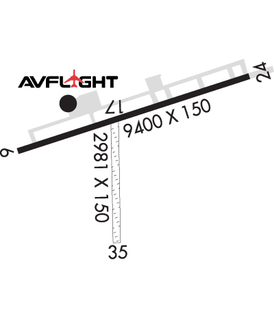
| Lat: N 3832.1 Long: W 10655.9 Elev: 7680 Var: -12 Longest Runway: 9400 | ||
| AWOS: 135.07 CTAF: 122.7 | ||
| ||||||||||||||||||||||||||||||||||||||||||||
| ||||||||||||||||||||||||||||||||||||||||||||
| ||||||||||||||||||||||||||||||||||||||||||||
| ||||||||||||||||||||||||||||||||||||||||||||
| Rwy | Rwy | |||||||
| 9400x150 | 9400' | 110.50 - 061° | 9400x150 | 9400' | ||||
| 2981x150 | 2981' | 2981x150 | 2748' | |||||
| Runway ID | Single Wheel | Double Wheel | Double Tandem Wheel | Dual Double Wheel |
| 06/24 | 75,000 | 160,000 | 250,000 | N/A |
| 17/35 | N/A | N/A | N/A | N/A |
| These numbers are Advisory and are not limits. The Airport Manager should have more accurate Weight Limits | ||||
 Airport Diagram might not be current. | |
| Facility Name: | GUNNISON-CRESTED BUTTE RGNL |
| City Name: | GUNNISON |
| County: | GUNNISON |
| State abbrev: | CO |
| State Name: | COLORADO |
| Ownership: | PUBLICLY OWNED |
| Use: | OPEN TO THE PUBLIC |
| Owner's Name: | COUNTY OF GUNNISON |
| Address: | 519 RIO GRANDE |
| GUNNISON, CO 81230 | |
| Owner's Phone: | 970-641-2304 |
| Manager's Name: | RICHARD LAMPORT |
| Address: | 519 RIO GRANDE |
| GUNNISON, CO 81230 | |
| Phone: | (970) 642-7388 |
| FAA Region: | NORTHWEST MOUNTAIN |
| FAA Field Office: | DEN |
| Date | Sunrise | Sunset |
|---|---|---|
| 06/08/26 Monday | 5:43 | 20:30 |
| 06/09/26 Tuesday | 5:43 | 20:31 |
| 06/10/26 Wednesday | 5:43 | 20:31 |
| 06/11/26 Thursday | 5:43 | 20:32 |
| 06/12/26 Friday | 5:43 | 20:32 |
| 06/13/26 Saturday | 5:43 | 20:33 |
| 06/14/26 Sunday | 5:43 | 20:33 |
| 06/15/26 Monday | 5:43 | 20:34 |
| 06/16/26 Tuesday | 5:43 | 20:34 |
| 06/17/26 Wednesday | 5:43 | 20:34 |
| 06/18/26 Thursday | 5:43 | 20:35 |
| 06/19/26 Friday | 5:43 | 20:35 |
| 06/20/26 Saturday | 5:43 | 20:35 |
| 06/21/26 Sunday | 5:44 | 20:35 |
| Airport Attendance Schedule | 7 Days A Week 0600-2100; ARPT CONDS UNMON AT NGT FM LAST ACR ARR/DEP TIL 0530 LCL. SEE NOTAMS FOR MOST UP-TO-DATE CONDS. |
| Airport Status | OPERATIONAL (This Status can change at any time - please check NOTAMS) |
| Airport Lighting Schedule | ACTVT MALSF RWY 06; PAPI RWY 06 & 24 - CTAF. REIL RWY 24; HIRL RWY 06/24 OPER 0600-2230.; ROTG BCN OPERS SS-2230 & 0600-SR. |
| Airport Storage Available | Tie Downs, Hanger |
| Extra Services Available | Air Freight, Air Ambulance, Flight Instruction, Annual Surveying |
| Wind Indicator | YES - (lighted) |
| Control Tower | NO |
| CTAF Frequency | 122.700 |
| Unicom Frequency | 122.700 |
| Rotating Beacon Color | WG |
| Segmented Circle | YES |
| Landing Fee | NO |
| Airport Inspected | FEDERAL - performed by FAA AIRPORTS FIELD PERSONNEL |
| Inspection Date | 07/14/2025 |
| Type of Fuel Available | Grade 100LL, JET A |
| Airframe Repair Service | NONE |
| Power Plant Repair Service | NONE |
| Latitude | N3832.1 |
| Longitude | W10655.9 (ESTIMATED) |
| Arpt Elevation | 7679ft (SURVEYED) |
| Magnetic Variation | 12E |
| 1 miles SW | of GUNNISON |
| Traffic Pattern Altitude | |
| Sectional Chart | DENVER |
| Operations (Reported) | Yearly | Avg. Daily |
|---|---|---|
| General Aviation Transient | 0 | 0 |
| General Aviation Local | 0 | 0 |
| Air Taxi | 0 | 0 |
| Commerical | 0 | 0 |
| Commuter | 0 | 0 |
| Military | 0 | 0 |
| Aircraft based on Field | |
|---|---|
| General Aviation Singles | 0 |
| General Aviation Multi | 0 |
| Jet Aircraft | 0 |
| General Aviation Helicopters | 0 |
| Military Aircraft | 0 |
| Gliders | 0 |
| Ultralights | 0 |
| FSS on field | NO |
| FSS tie-in | DENVER |
| FSS Phone | 1-800-WX-BRIEF |
| Who issues Notams | GUC |
| Notam D service at airport | YES |
| ARTCC Name | DENVER |
| Airport Certification | AIRPORT RECEIVING SCHEDULED AIR CARRIER SERVICE FROM CARRIERS CERTIFICATED BY THE CIVIL AERONAUTICS BOARD; CLSD TO UNSKED ACR OPS WITH MORE THAN 30 PAX SEATS EXCP PPR. CALL AMGR 970-641-2304. |
| Aircraft Rescue & Firefighting Index | AIRPORT HAS A CERTIFICATE UNDER CFR PART 139 |
| Airport of Entry | No |
| Custom Landing Rights | No |
| Joint Civil/Military | No |
| Military Landing rights | YES |
| NATIONAL PLAN OF INTEGRATED AIRPORT SYSTEMS (NPIAS) |
| GRANT AGREEMENTS UNDER FAAP/ADAP/AIP |
| ASSURANCES PURSUANT TO TITLE VI, CIVIL RIGHTS ACT OF 1964 |
| HIGH TRRN ALL QUADS. |
| RWY 17/35 CLSD 1 DEC - 1 MAY. |
| COLD TEMPERATURE AIRPORT. ALTITUDE CORRECTION REQUIRED AT OR BELOW -25C. |
| MIGRATORY BIRD ACT 1 JAN -THRU- 1 JUN. |
| RWY 06/2 4 PCR VALUE: 410/F/B/X/T |
Airport Communications & Frequencies:
| |||||||||
| Runway: 06 | Runway: 24 | ||
| Mag heading: | 62° | Mag heading: | 242° |
| Rwy Slope: | .23% Up | Rwy Slope: | -.23% Down |
| Approach: | ILS/DME | Approach: | |
| Pattern: | Right Traffic | Pattern: | Left Traffic |
| Markings: | PRECISION INSTRUMENT | Markings: | NONPRECISION INSTRUMENT |
| Marking Condition: | GOOD | Marking Condition: | GOOD |
| Arresting Dev: | Arresting Dev: | ||
| Lat & Long: | N3831.9 W10656.7 | Lat. & Long.: | N3832.4 W10654.8 |
| Elev: | 7658.0 ft. MSL | Elev: | 7679.5 ft. MSL |
| TCH: | 49 ft. AGL | TCH: | 71 ft. AGL |
| Visual Glide Path: | 3.20 degrees | Visual Glide Path: | 3.60 degrees |
| Displaced Threshold: | No | Displaced Threshold: | No |
| Touchdown Zone: | YES | Touchdown Zone: | YES |
| Touchdown Elev.: | 7667.2 feet | Touchdown Elev.: | 7679.6 feet |
| Visual Glide Slope: | 4-Light PAPI on LEFT side of Runway | Visual Glide Slope: | 4-Light PAPI on LEFT side of Runway; PAPI UNUSBL BYD 2.5 NM; DOES NOT PRVD OBST CLNC BYD 2.5 NM FROM THR. |
| RVR Equipment: | RVR Equipment: | ||
| RVV Equipment: | NO | RVV Equipment: | NO |
| Approach Lights: | MALSF - 1,400 foot medium intensity approach lighting system with sequenced flashers | Approach Lights: | |
| REIL: | NO | REIL: | YES |
| Centerline Lights: | NO | Centerline Lights: | NO |
| Touchdown lights: | NO | Touchdown lights: | NO |
| Runway Category: | Precision Instrument Runway | Runway Category: | Runway with a Visual Approach |
| Declared Distances: | TORA:9400' TODA:9400' ASDA:9400' LDA:9400' | Declared Distances: | TORA:9400' TODA:9400' ASDA:9400' LDA:9400' |
| Runway: 17 | Runway: 35 | ||
| Mag heading: | 168° | Mag heading: | 348° |
| Rwy Slope: | -.46% Down | Rwy Slope: | .46% Up |
| Approach: | Approach: | ||
| Pattern: | Right Traffic | Pattern: | Left Traffic |
| Markings: | NONE | Markings: | NONE |
| Marking Condition: | FAIR | Marking Condition: | FAIR |
| Arresting Dev: | Arresting Dev: | ||
| Lat & Long: | N3832.0 W10656.4 | Lat. & Long.: | N3831.5 W10656.4 |
| Elev: | 7660.9 ft. MSL | Elev: | 7647.3 ft. MSL |
| TCH: | TCH: | ||
| Visual Glide Path: | Visual Glide Path: | ||
| Displaced Threshold: | No | Displaced Threshold: | 233 feet |
| Touchdown Zone: | YES | Touchdown Zone: | YES |
| Touchdown Elev.: | 7660.9 feet | Touchdown Elev.: | 7660.9 feet |
| Visual Glide Slope: | Visual Glide Slope: | ||
| RVR Equipment: | RVR Equipment: | ||
| RVV Equipment: | NO | RVV Equipment: | NO |
| Approach Lights: | Approach Lights: | ||
| REIL: | NO | REIL: | NO |
| Centerline Lights: | NO | Centerline Lights: | NO |
| Touchdown lights: | NO | Touchdown lights: | NO |
| Runway Category: | Runway with a Visual Approach | Runway Category: | Runway with a Visual Approach |
| Declared Distances: | TORA:2981' TODA:2981' ASDA:2981' LDA:2981' | Declared Distances: | TORA:2981' TODA:2981' ASDA:2981' LDA:2748' |
Thanks for using FltPlan.com
all rights reserved © 1999-2026 by Flight Plan LLC
