
| GRANTSBURG MUNI GRANTSBURG WI |
| |
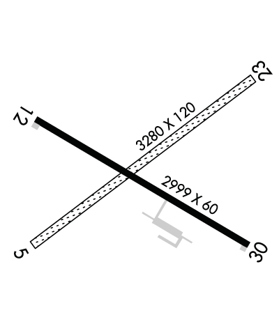
| Lat: N 4547.9 Long: W 09239.9 Elev: 927 Var: -00 Longest Runway: 3280 | ||
| CTAF: 122.9 | ||
| ||||||||||||||||||||||||||||||||
| ||||||||||||||||||||||||||||||||
| Rwy | Rwy | |||||||
| 3280x120 | 3280' | 3280x120 | 3280' | |||||
| 2999x60 | 2999' | 2999x60 | 2999' | |||||
| Runway ID | Single Wheel | Double Wheel | Double Tandem Wheel | Dual Double Wheel |
| 05/23 | N/A | N/A | N/A | N/A |
| 12/30 | N/A | N/A | N/A | N/A |
| These numbers are Advisory and are not limits. The Airport Manager should have more accurate Weight Limits | ||||
 Airport Diagram might not be current. | |
| Facility Name: | GRANTSBURG MUNI |
| City Name: | GRANTSBURG |
| County: | BURNETT |
| State abbrev: | WI |
| State Name: | WISCONSIN |
| Ownership: | PUBLICLY OWNED |
| Use: | OPEN TO THE PUBLIC |
| Owner's Name: | VILLAGE OF GRANTSBURG |
| Address: | 316 S. BRAD ST |
| GRANTSBURG, WI 54840 | |
| Owner's Phone: | 715-463-2405 |
| Manager's Name: | SHEILA MEYER |
| Address: | 316 S. BRAD ST; EMAIL ADDRESS: OFFICE@VILLAGEOFGRANTSBURG.GOV |
| GRANTSBURG, WI 54840 | |
| Phone: | 715-463-2405 |
| FAA Region: | GREAT LAKES |
| FAA Field Office: | CHI |
| Date | Sunrise | Sunset |
|---|---|---|
| 06/08/26 Monday | 5:21 | 20:58 |
| 06/09/26 Tuesday | 5:21 | 20:59 |
| 06/10/26 Wednesday | 5:21 | 21:00 |
| 06/11/26 Thursday | 5:20 | 21:00 |
| 06/12/26 Friday | 5:20 | 21:01 |
| 06/13/26 Saturday | 5:20 | 21:01 |
| 06/14/26 Sunday | 5:20 | 21:02 |
| 06/15/26 Monday | 5:20 | 21:02 |
| 06/16/26 Tuesday | 5:20 | 21:03 |
| 06/17/26 Wednesday | 5:20 | 21:03 |
| 06/18/26 Thursday | 5:20 | 21:03 |
| 06/19/26 Friday | 5:20 | 21:04 |
| 06/20/26 Saturday | 5:20 | 21:04 |
| 06/21/26 Sunday | 5:21 | 21:04 |
| Airport Attendance Schedule | UNATTENDED |
| Airport Status | OPERATIONAL (This Status can change at any time - please check NOTAMS) |
| Airport Lighting Schedule | ACTVT MIRL RWY 12/30 - CTAF. |
| Airport Storage Available | Tie Downs |
| Extra Services Available | NONE |
| Wind Indicator | YES - (lighted) |
| Control Tower | NO |
| CTAF Frequency | 122.900 |
| Unicom Frequency | |
| Rotating Beacon Color | WG |
| Segmented Circle | YES |
| Landing Fee | NO |
| Airport Inspected | STATE - performed by STATE AERONAUTICAL PERSONNEL |
| Inspection Date | 07/18/2024 |
| Type of Fuel Available | None |
| Airframe Repair Service | None |
| Power Plant Repair Service | None |
| Latitude | N4547.9 |
| Longitude | W09239.9 (ESTIMATED) |
| Arpt Elevation | 927ft (SURVEYED) |
| Magnetic Variation | 00E |
| 2 miles NE | of GRANTSBURG |
| Traffic Pattern Altitude | |
| Sectional Chart | GREEN BAY |
| Operations (Reported) | Yearly | Avg. Daily |
|---|---|---|
| General Aviation Transient | 0 | 0 |
| General Aviation Local | 0 | 0 |
| Air Taxi | 0 | 0 |
| Commerical | 0 | 0 |
| Commuter | 0 | 0 |
| Military | 0 | 0 |
| Aircraft based on Field | |
|---|---|
| General Aviation Singles | 0 |
| General Aviation Multi | 0 |
| Jet Aircraft | 0 |
| General Aviation Helicopters | 0 |
| Military Aircraft | 0 |
| Gliders | 0 |
| Ultralights | 0 |
| FSS on field | NO |
| FSS tie-in | GREEN BAY |
| FSS Phone | 1-800-WX-BRIEF |
| Who issues Notams | GRB |
| Notam D service at airport | YES |
| ARTCC Name | MINNEAPOLIS |
| Airport Certification | |
| Aircraft Rescue & Firefighting Index | None |
| Airport of Entry | No |
| Custom Landing Rights | No |
| Joint Civil/Military | No |
| Military Landing rights | YES |
| NATIONAL PLAN OF INTEGRATED AIRPORT SYSTEMS (NPIAS) |
| GRANT AGREEMENTS UNDER FAAP/ADAP/AIP |
| ASSURANCES PURSUANT TO TITLE VI, CIVIL RIGHTS ACT OF 1964 |
| DEER & WATERFOWL ON AND INVOF ARPT. |
| 1100 FT MSL/182 FT AGL WATER TWR LCTD 5060 FT SW RWY 05. |
| FOR CD CTC MINNEAPOLIS ARTCC AT 651-463-5588. |
| RWY 05/2 3 CLSD NOV 1 - APR 15. |
| RWY 12/3 0 NUMEROUS CRACKS AND VEGETATION IN PAVEMENT. |
Airport Communications & Frequencies:
| |||||||
| Runway: 05 | Runway: 23 | ||
| Mag heading: | 56° | Mag heading: | 236° |
| Rwy Slope: | .00% Up | Rwy Slope: | .00% Down |
| Approach: | Approach: | ||
| Pattern: | Left Traffic | Pattern: | Left Traffic |
| Markings: | Markings: | ||
| Marking Condition: | RWY 05/23 MKD WITH YELLOW CONES. | Marking Condition: | |
| Arresting Dev: | Arresting Dev: | ||
| Lat & Long: | N4547.8 W09240.2 | Lat. & Long.: | N4548.1 W09239.5 |
| Elev: | 924.1 ft. MSL | Elev: | 924.2 ft. MSL |
| TCH: | TCH: | ||
| Visual Glide Path: | Visual Glide Path: | ||
| Displaced Threshold: | No | Displaced Threshold: | No |
| Touchdown Zone: | YES | Touchdown Zone: | YES |
| Touchdown Elev.: | 927.1 feet | Touchdown Elev.: | 927.1 feet |
| Visual Glide Slope: | Visual Glide Slope: | ||
| RVR Equipment: | RVR Equipment: | ||
| RVV Equipment: | NO | RVV Equipment: | NO |
| Approach Lights: | Approach Lights: | ||
| REIL: | NO | REIL: | NO |
| Centerline Lights: | NO | Centerline Lights: | NO |
| Touchdown lights: | NO | Touchdown lights: | NO |
| Runway Category: | Runway with a Visual Approach | Runway Category: | Runway with a Visual Approach |
| Declared Distances: | Declared Distances: | ||
| Obstructions: | Obstructions: | TREES | |
| Marked: | Marked: | NOT Marked/Lighted | |
| Clearance slope: | 20:1 | Clearance slope: | 7:1 |
| Obstruction height: | Obstruction height: | 30 feet AGL | |
| Dist. from runway: | Dist. from runway: | 225 feet | |
| Centerline offset: | Centerline offset: | 125 feet right of centerline | |
| Comments: | Comments: |
| Runway: 12 | Runway: 30 | ||
| Mag heading: | 121° | Mag heading: | 301° |
| Rwy Slope: | -.02% Down | Rwy Slope: | .02% Up |
| Approach: | Approach: | ||
| Pattern: | Left Traffic | Pattern: | Left Traffic |
| Markings: | NONPRECISION INSTRUMENT | Markings: | NONPRECISION INSTRUMENT |
| Marking Condition: | POOR; MARKINGS FADED. | Marking Condition: | POOR; MARKINGS FADED. |
| Arresting Dev: | Arresting Dev: | ||
| Lat & Long: | N4548.0 W09240.2 | Lat. & Long.: | N4547.8 W09239.6 |
| Elev: | 924.2 ft. MSL | Elev: | 923.6 ft. MSL |
| TCH: | TCH: | ||
| Visual Glide Path: | Visual Glide Path: | ||
| Displaced Threshold: | No | Displaced Threshold: | No |
| Touchdown Zone: | YES | Touchdown Zone: | YES |
| Touchdown Elev.: | 926.7 feet | Touchdown Elev.: | 926.7 feet |
| Visual Glide Slope: | Visual Glide Slope: | ||
| RVR Equipment: | RVR Equipment: | ||
| RVV Equipment: | NO | RVV Equipment: | NO |
| Approach Lights: | Approach Lights: | ||
| REIL: | NO | REIL: | NO |
| Centerline Lights: | NO | Centerline Lights: | NO |
| Touchdown lights: | NO | Touchdown lights: | NO |
| Runway Category: | Runway with a Non-precision Approach | Runway Category: | Runway with a Non-precision Approach |
| Declared Distances: | Declared Distances: | ||
| Obstructions: | TREES | Obstructions: | TREES |
| Marked: | NOT Marked/Lighted | Marked: | NOT Marked/Lighted |
| Clearance slope: | 6:1 | Clearance slope: | 10:1 |
| Obstruction height: | 20 feet AGL | Obstruction height: | 50 feet AGL |
| Dist. from runway: | 330 feet | Dist. from runway: | 700 feet |
| Centerline offset: | 225 left of centerline | Centerline offset: | 300 feet left of centerline |
| Comments: | Comments: |
Thanks for using FltPlan.com
all rights reserved © 1999-2026 by Flight Plan LLC
