
| GREAT FALLS INTL GREAT FALLS MT |
| |
| Lat: N 4728.9 Long: W 11122.2 Elev: 3680 Var: -13 Longest Runway: 10502 | ||
| Clr Del: 121.7 Dept. ATIS: 126.6 Arr. ATIS: 126.6 Ground: 121.7 Tower: 118.7 | ||
| |||||||||||||||||||||||||||||||||||||||||||||||||||||||||||||||||||||
| |||||||||||||||||||||||||||||||||||||||||||||||||||||||||||||||||||||
| |||||||||||||||||||||||||||||||||||||||||||||||||||||||||||||||||||||
| |||||||||||||||||||||||||||||||||||||||||||||||||||||||||||||||||||||
| FBOs at nearby airports who want your business: | |||||||||||||||||
| |||||||||||||||||
| Rwy | Rwy | |||||||
| 10502x150 | 10502' | 111.30 - 032° | 10502x150 | 10502' | ||||
| 6030x150 | 5800' | 6030x150 | 6030' | |||||
| Runway ID | Single Wheel | Double Wheel | Double Tandem Wheel | Dual Double Wheel |
| 03/21 | 116,000 | 225,000 | 424,000 | 915,000 |
| 17/35 | 87,000 | 140,000 | 245,000 | 245,000 |
| These numbers are Advisory and are not limits. The Airport Manager should have more accurate Weight Limits | ||||
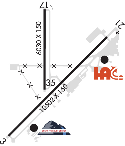 Airport Diagram might not be current. | |
| Facility Name: | GREAT FALLS INTL |
| City Name: | GREAT FALLS |
| County: | CASCADE |
| State abbrev: | MT |
| State Name: | MONTANA |
| Ownership: | PUBLICLY OWNED |
| Use: | OPEN TO THE PUBLIC |
| Owner's Name: | GREAT FALLS INTL ARPT AUTH |
| Address: | 2800 TERMINAL DR |
| GREAT FALLS, MT 59404-5599 | |
| Owner's Phone: | 406-727-3404 |
| Manager's Name: | JOHN FAULKNER |
| Address: | 2800 TERMINAL DRIVE |
| GREAT FALLS, MT 59404-5599 | |
| Phone: | 406-727-3404 |
| FAA Region: | NORTHWEST MOUNTAIN |
| FAA Field Office: | HLN |
| Date | Sunrise | Sunset |
|---|---|---|
| 06/08/26 Monday | 5:29 | 21:20 |
| 06/09/26 Tuesday | 5:29 | 21:21 |
| 06/10/26 Wednesday | 5:28 | 21:22 |
| 06/11/26 Thursday | 5:28 | 21:22 |
| 06/12/26 Friday | 5:28 | 21:23 |
| 06/13/26 Saturday | 5:28 | 21:23 |
| 06/14/26 Sunday | 5:28 | 21:24 |
| 06/15/26 Monday | 5:28 | 21:24 |
| 06/16/26 Tuesday | 5:28 | 21:25 |
| 06/17/26 Wednesday | 5:28 | 21:25 |
| 06/18/26 Thursday | 5:28 | 21:26 |
| 06/19/26 Friday | 5:28 | 21:26 |
| 06/20/26 Saturday | 5:28 | 21:26 |
| 06/21/26 Sunday | 5:28 | 21:26 |
| Airport Attendance Schedule | CONTINUOUS |
| Airport Status | OPERATIONAL (This Status can change at any time - please check NOTAMS) |
| Airport Lighting Schedule | REIL RWY 21 OPR CONSLY WHEN RWY LGTS ARE ON. RWY LGTS CTLD BY TWR. |
| Airport Storage Available | Tie Downs, Hanger |
| Extra Services Available | Air Freight, Crop Dusting, Avionics, Cargo Handling, Charter, Flight Instruction, Aircraft Rental, Aircraft Sales |
| Wind Indicator | YES - (unlit) |
| Control Tower | YES |
| CTAF Frequency | |
| Unicom Frequency | 122.950 |
| Rotating Beacon Color | WG |
| Segmented Circle | YES |
| Landing Fee | NO |
| Airport Inspected | FEDERAL - performed by FAA AIRPORTS FIELD PERSONNEL |
| Inspection Date | 03/19/2025 |
| Type of Fuel Available | Grade 100LL, JET A (freeze point -40C) |
| Airframe Repair Service | MAJOR |
| Power Plant Repair Service | MAJOR |
| Latitude | N4728.9 |
| Longitude | W11122.2 (ESTIMATED) |
| Arpt Elevation | 3680ft (SURVEYED) |
| Magnetic Variation | 13E |
| 3 miles SW | of GREAT FALLS |
| Traffic Pattern Altitude | |
| Sectional Chart | GREAT FALLS |
| Operations (Reported) | Yearly | Avg. Daily |
|---|---|---|
| General Aviation Transient | 0 | 0 |
| General Aviation Local | 0 | 0 |
| Air Taxi | 0 | 0 |
| Commerical | 0 | 0 |
| Commuter | 0 | 0 |
| Military | 0 | 0 |
| Aircraft based on Field | |
|---|---|
| General Aviation Singles | 0 |
| General Aviation Multi | 0 |
| Jet Aircraft | 0 |
| General Aviation Helicopters | 0 |
| Military Aircraft | 0 |
| Gliders | 0 |
| Ultralights | 0 |
| FSS on field | NO |
| FSS tie-in | GREAT FALLS |
| FSS Phone | 1-800-WX-BRIEF |
| Who issues Notams | GTF |
| Notam D service at airport | YES |
| ARTCC Name | SALT LAKE CITY |
| Airport Certification | AIRPORT RECEIVING SCHEDULED AIR CARRIER SERVICE FROM CARRIERS CERTIFICATED BY THE CIVIL AERONAUTICS BOARD; INDEX LEVEL C ARFF CAPABILITY IS AVBL AT ALL TIMES. |
| Aircraft Rescue & Firefighting Index | AIRPORT HAS A CERTIFICATE UNDER CFR PART 139 |
| Airport of Entry | YES |
| Custom Landing Rights | No |
| Joint Civil/Military | No |
| Military Landing rights | YES |
| NATIONAL PLAN OF INTEGRATED AIRPORT SYSTEMS (NPIAS) |
| GRANT AGREEMENTS UNDER FAAP/ADAP/AIP |
| SURPLUS PROPERTY AGREEMENT UNDER PUBLIC LAW 289 |
| ASSURANCES PURSUANT TO TITLE VI, CIVIL RIGHTS ACT OF 1964 |
| AGREEMENT UNDER DLAND OR DCLA HAS EXPIRED. |
| TWY C UNRSTD WT AND AVBL FOR TAXIING ACFT. |
| MILITARY: ANG: OPR 1400-2330Z++ MON-THU, LTD FRI, CLOSED SAT-SUN AND HOL. BASE OPS DSN 791-0192, C406-791-0192. NO TRAN SVC SAT, SUN, HOL OR AFTER 2300Z++ MON-FRI. ACFT RQR ASSISTANCE CTC 288.9. RCR INFO AVBL FR BASE OPS. |
| MILITARY: ANG: LTD TRAN SVC ONLY AVBL FOR ACFT PARTICIPATING IN ANG OPS WITH PRIOR COORDINATION (PPR). |
| BIRDS ON AND INVOF ARPT. |
| MILITARY: ANG: USAF BASH - EXP INCREASED MIGRATORY WATERFOWL ACT (PHASE II) MAR-MAY AND SEP-DEC, SR-.5 TO SS+.5. |
| MILITARY: ANG: NSTD WHITE EQPT TOOL BOX LCTN PAINTED ON RAMP. |
| MILITARY: ANG: FUEL: A++ AVBL AT ANG. |
| RWY 03/2 1 FOR DC-10-40 AND B747. |
| RWY 03/2 1 PCR VALUE: 5290/F/B/X/T |
| RWY 17/3 5 PCR VALUE: 300/F/B/X/U |
Airport Communications & Frequencies:
| ||||||||||||||||||||||||||||||||||||||||
| Runway: 03 | Runway: 21 | ||
| Mag heading: | 32° | Mag heading: | 212° |
| Rwy Slope: | -.20% Down | Rwy Slope: | .20% Up |
| Approach: | ILS/DME | Approach: | |
| Pattern: | Left Traffic | Pattern: | Left Traffic |
| Markings: | PRECISION INSTRUMENT | Markings: | PRECISION INSTRUMENT |
| Marking Condition: | GOOD | Marking Condition: | GOOD |
| Arresting Dev: | Arresting Dev: | ||
| Lat & Long: | N4728.2 W11123.0 | Lat. & Long.: | N4729.4 W11121.2 |
| Elev: | 3680.0 ft. MSL | Elev: | 3659.3 ft. MSL |
| TCH: | 70 ft. AGL | TCH: | 75 ft. AGL |
| Visual Glide Path: | 3.00 degrees | Visual Glide Path: | 3.00 degrees |
| Displaced Threshold: | No | Displaced Threshold: | No |
| Touchdown Zone: | YES | Touchdown Zone: | YES |
| Touchdown Elev.: | 3680.0 feet | Touchdown Elev.: | 3669.2 feet |
| Visual Glide Slope: | 4-Light PAPI on LEFT side of Runway; PAPI UNUSBL BYD 9 DEGS RIGHT OF CNTRLN. | Visual Glide Slope: | 4-Light PAPI on RIGHT side of Runway |
| RVR Equipment: | TOUCHDOWN-MIDFIELD-ROLLOUT | RVR Equipment: | TOUCHDOWN-MIDFIELD-ROLLOUT |
| RVV Equipment: | NO | RVV Equipment: | NO |
| Approach Lights: | ALSF2 - standard 2,400 foot high intensity approach lighting system with sequenced flashers, Category II or III | Approach Lights: | |
| REIL: | NO | REIL: | YES |
| Centerline Lights: | YES | Centerline Lights: | YES |
| Touchdown lights: | YES | Touchdown lights: | NO |
| Runway Category: | Precision Instrument Runway | Runway Category: | D |
| Declared Distances: | TORA:10502' TODA:10502' ASDA:10502' LDA:10502' | Declared Distances: | TORA:10502' TODA:10502' ASDA:10502' LDA:10502' |
| Obstructions: | ROAD | Obstructions: | |
| Marked: | NOT Marked/Lighted | Marked: | |
| Clearance slope: | 43:1 | Clearance slope: | 34:1 |
| Obstruction height: | 25 feet AGL | Obstruction height: | |
| Dist. from runway: | 1300 feet | Dist. from runway: | |
| Centerline offset: | 645 right of centerline | Centerline offset: | |
| Comments: | Comments: |
| Runway: 17 | Runway: 35 | ||
| Mag heading: | 167° | Mag heading: | 347° |
| Rwy Slope: | .46% Up | Rwy Slope: | -.46% Down |
| Approach: | Approach: | ||
| Pattern: | Left Traffic | Pattern: | Left Traffic |
| Markings: | NONPRECISION INSTRUMENT | Markings: | NONPRECISION INSTRUMENT |
| Marking Condition: | GOOD | Marking Condition: | GOOD |
| Arresting Dev: | Arresting Dev: | ||
| Lat & Long: | N4729.7 W11122.4 | Lat. & Long.: | N4728.7 W11122.4 |
| Elev: | 3640.2 ft. MSL | Elev: | 3667.9 ft. MSL |
| TCH: | 47 ft. AGL | TCH: | 48 ft. AGL |
| Visual Glide Path: | 3.00 degrees | Visual Glide Path: | 3.00 degrees |
| Displaced Threshold: | 230 feet | Displaced Threshold: | No |
| Touchdown Zone: | YES | Touchdown Zone: | YES |
| Touchdown Elev.: | 3659.8 feet | Touchdown Elev.: | 3667.9 feet |
| Visual Glide Slope: | 4-Light PAPI on LEFT side of Runway | Visual Glide Slope: | 4-Light PAPI on LEFT side of Runway |
| RVR Equipment: | RVR Equipment: | ||
| RVV Equipment: | NO | RVV Equipment: | NO |
| Approach Lights: | Approach Lights: | ||
| REIL: | NO | REIL: | NO |
| Centerline Lights: | NO | Centerline Lights: | NO |
| Touchdown lights: | NO | Touchdown lights: | NO |
| Runway Category: | Runway with a Non-precision Approach having visibility minimums greater than 3/4 mile | Runway Category: | Runway with a Non-precision Approach having visibility minimums greater than 3/4 mile |
| Declared Distances: | TORA:6030' TODA:6030' ASDA:6030' LDA:5800' | Declared Distances: | TORA:5400' TODA:5400' ASDA:5400' LDA:5400' |
| Obstructions: | ROAD | Obstructions: | |
| Marked: | NOT Marked/Lighted | Marked: | |
| Clearance slope: | 14:1 | Clearance slope: | 34:1 |
| Obstruction height: | 10 feet AGL | Obstruction height: | |
| Dist. from runway: | 345 feet | Dist. from runway: | |
| Centerline offset: | 266 left of centerline | Centerline offset: | |
| Comments: | Comments: |
Thanks for using FltPlan.com
all rights reserved © 1999-2026 by Flight Plan LLC