
| WHEELER-SACK AAF (PRIVATE) FORT DRUM NY |
| |
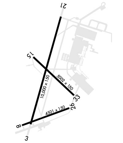
| Lat: N 4403.3 Long: W 07543.2 Elev: 690 Var: +13 Longest Runway: 10000 | ||
| Clr Del: 123.65 Dept. ATIS: 119.52 Arr. ATIS: 119.52 Ground: 123.45 Tower: 118.75 | ||
| ||||||
|
| Rwy | Rwy | |||||||
| 10000x150 | 8637' | 108.50 - 029° | 10000x150 | 10000' | 108.50 - 209° | |||
| 4501x150 | 4501' | 4501x150 | 4501' | |||||
| 5002x144 | 5002' | 5002x144 | 5002' | |||||
| Runway ID | Single Wheel | Double Wheel | Double Tandem Wheel | Dual Double Wheel |
| 03/21 | N/A | N/A | N/A | N/A |
| 08/26 | N/A | N/A | N/A | N/A |
| 15/33 | N/A | N/A | N/A | N/A |
| These numbers are Advisory and are not limits. The Airport Manager should have more accurate Weight Limits | ||||
 Airport Diagram might not be current. | |
| Facility Name: | WHEELER-SACK AAF |
| City Name: | FORT DRUM |
| County: | JEFFERSON |
| State abbrev: | NY |
| State Name: | NEW YORK |
| Ownership: | ARMY OWNED |
| Use: | PRIVATE |
| Owner's Name: | US ARMY AERONAUTICAL SVCS AGENCY |
| Address: | |
| FORT BELVOIR, VA 22060 | |
| Owner's Phone: | |
| Manager's Name: | |
| Address: | |
| Phone: | |
| FAA Region: | EASTERN |
| FAA Field Office: | NYC |
| Date | Sunrise | Sunset |
|---|---|---|
| 06/07/26 Sunday | 5:20 | 20:43 |
| 06/08/26 Monday | 5:20 | 20:44 |
| 06/09/26 Tuesday | 5:20 | 20:45 |
| 06/10/26 Wednesday | 5:20 | 20:45 |
| 06/11/26 Thursday | 5:19 | 20:46 |
| 06/12/26 Friday | 5:19 | 20:46 |
| 06/13/26 Saturday | 5:19 | 20:47 |
| 06/14/26 Sunday | 5:19 | 20:47 |
| 06/15/26 Monday | 5:19 | 20:48 |
| 06/16/26 Tuesday | 5:19 | 20:48 |
| 06/17/26 Wednesday | 5:19 | 20:48 |
| 06/18/26 Thursday | 5:19 | 20:49 |
| 06/19/26 Friday | 5:19 | 20:49 |
| 06/20/26 Saturday | 5:20 | 20:49 |
| Airport Attendance Schedule | MON-FRI 0700-2200; OTR TIMES PPR. ARPT CLSD HOLS. |
| Airport Status | OPERATIONAL (This Status can change at any time - please check NOTAMS) |
| Airport Lighting Schedule | SS-SR |
| Airport Storage Available | NONE |
| Extra Services Available | NONE |
| Wind Indicator | NONE |
| Control Tower | YES |
| CTAF Frequency | |
| Unicom Frequency | |
| Rotating Beacon Color | SWG; LCTD ON 847'MSL TOWER WEST OF RWY 8. |
| Segmented Circle | NO |
| Landing Fee |
| Airport Inspected | No Inspection Data Available performed by the OWNER |
| Inspection Date | Unknown |
| Type of Fuel Available | None |
| Airframe Repair Service | None |
| Power Plant Repair Service | None |
| Latitude | N4403.3 |
| Longitude | W07543.2 (ESTIMATED) |
| Arpt Elevation | 689ft (SURVEYED) |
| Magnetic Variation | 13W |
| 1 miles NE | of FORT DRUM |
| Traffic Pattern Altitude | R/W 1400 FT, F/W 2000 FT TURBO JET 2500 FT, OVERHEAD 3000 FT. |
| Sectional Chart | MONTREAL |
| Operations (Reported) | Yearly | Avg. Daily |
|---|---|---|
| General Aviation Transient | 0 | 0 |
| General Aviation Local | 0 | 0 |
| Air Taxi | 0 | 0 |
| Commerical | 0 | 0 |
| Commuter | 0 | 0 |
| Military | 0 | 0 |
| Aircraft based on Field | |
|---|---|
| General Aviation Singles | 0 |
| General Aviation Multi | 0 |
| Jet Aircraft | 0 |
| General Aviation Helicopters | 0 |
| Military Aircraft | 0 |
| Gliders | 0 |
| Ultralights | 0 |
| FSS on field | NO |
| FSS tie-in | BURLINGTON |
| FSS Phone | 1-800-WX-BRIEF |
| Who issues Notams | GTB |
| Notam D service at airport | YES |
| ARTCC Name | BOSTON |
| Airport Certification | |
| Aircraft Rescue & Firefighting Index | None |
| Airport of Entry | No |
| Custom Landing Rights | No |
| Joint Civil/Military | No |
| Military Landing rights | No |
| SERVICE-L-AOE JASU-3(ASU600-270-DDP). FUEL-A++ (MIL); AVBL 1400-0300Z++MON-FRI, EXC HOL, OT PN. |
| MISC: WX SVC AVBL 24/7. DSN 772-6065, C315-772-6065. BACK-UP WX BRIEF AVBL FR 15 OWS SCOTT AFB DSN 576-9755/9702, C618-256-9755/9702. PRI WX SENSORS AUTOMATED H24. DRG AUGMENTATION/BACK-UP WX OBSERVATION PT IS OBST 033 DEGS-162 DEGS. PMSV FREQ NOT MONITORED SAT, SUN, AND FEDERAL HOL. |
| NS ABTMT - QUIET HRS 0300-1100Z++. |
| CUST/AG/IMG: 24 HR PN, CONSULT FCG. AERIAL PORT MSN ACFT PLAN ARR BTN 1300-0300Z++ MON-FRI EXC HOL, OT RQR ADVANCED COORD AND APVL. |
| RWY 03/21 ACLT STOP AND TKOF RUN DIST AVBL 10000 FT. |
| TFC PAT - R/W 1400 FT, F/W 2000 FT. TURBO JET 2500 FT. OVHD 3000 FT. |
| TWY G RSTD TO C130 OR SMALLER, MAX ACN 25. |
| SECTION OF RWY 08/26 BTN RWY 03/21 AND TWY D RATED CONC PCN 54 R/B/W/T. |
| TRAN ALERT: NO CATERING, CLEANING, LAV, TRASH REMOVAL, WATER, OR CREW TRNSP SVC AVBL. |
| BASE OPS OPR 1200-0400Z++ MON-FRI; CLSD SAT, SUN AND FEDERAL HOL. ALL TRAN ACFT INBD FOR PRK CTC BASE OPS 10 NM PRIOR TO LDG, MIL AIRCREWS MUST REGISTER WITH BASE OPS IF RON. TRAN R/W PRK SOUTH END OF NORTH RAMP. TWY G, N, P, R AND TWY L EAST OF TWY B DESIGNATED NONMOVEMENT AREA. ACFT INBD FOR AVN FLD MAINT ACT (AFMA) MUST ARR NO LATER THAN 1900Z++ CTC DSN 772-7536 C315-772-7536. EMERG CTC MT OPS CNTR DSN 772-8620 C315-772-8620. |
| FLUID - SP DE-ICE TYPE I AND IV AVBL WITH 3 HR PN. |
| RSTD: PPR CTC BASE OPS DSN 772-5681 C315-772-5681/5682. TENANT ACFT HAVE PRIORITY FOR LCL PAT OPS, TRAN MAY BE LTD. RWY 15-33.TWY G RSTD TO C130 OR SMALLER. SOD LDG/OPS RSTD TO CNTR, SOD. OASIS RST TO TENANT R/W HOT REFUL OPS, LDG/DEP PROHIBITED WHEN CLSD. TWY B BTN TWY A AND N RAMP CLSD. |
| CTN: UAS OPR WI 20NM KGTB SFC-FL290. EXTSY MIL ACFT ACTIVITY VCNTY ARPT MIL ACFT REFER TO FLIP AP/1 PRIOR TO OPS ON FORT DRUM OR WI R-5201. NARROW TWY A,B INT ARC 40 FT WIDE. N RAMP EDGE LGT US. TWY B EDGE LGT US BTN TWY A AND SABRE HELIPAD. W RAMP UNLGTD. RSC NOT MNTN WHEN BASE OPS IS CLSD. WILDLIFE HAZ, REFER TO AP/1. |
| RWY 08/2 6 RWY 08/26 CNTR 75 FT CONC BTN RWY 03 AND TWY D, PCN 54, REMAINDER ASPH. |
Airport Communications & Frequencies:
| |||||||||||||||||||||||||||
| Runway: 03 | Runway: 21 | ||
| Mag heading: | N/A | Mag heading: | N/A |
| Rwy Slope: | -.19% Down | Rwy Slope: | .19% Up |
| Approach: | ILS/DME | Approach: | ILS/DME |
| Pattern: | Left Traffic | Pattern: | Right Traffic |
| Markings: | PRECISION INSTRUMENT | Markings: | PRECISION INSTRUMENT |
| Marking Condition: | GOOD | Marking Condition: | GOOD |
| Arresting Dev: | Arresting Dev: | ||
| Lat & Long: | N4402.7 W07543.5 | Lat. & Long.: | N4404.3 W07542.9 |
| Elev: | 679.3 ft. MSL | Elev: | 660.5 ft. MSL |
| TCH: | 64 ft. AGL | TCH: | 72 ft. AGL |
| Visual Glide Path: | 3.00 degrees | Visual Glide Path: | 3.00 degrees |
| Displaced Threshold: | 1363 feet | Displaced Threshold: | No |
| Touchdown Zone: | YES | Touchdown Zone: | YES |
| Touchdown Elev.: | 685.4 feet | Touchdown Elev.: | 677.3 feet |
| Visual Glide Slope: | 4-Light PAPI on LEFT side of Runway | Visual Glide Slope: | 4-Light PAPI on LEFT side of Runway |
| RVR Equipment: | TOUCHDOWN-ROLLOUT | RVR Equipment: | TOUCHDOWN-ROLLOUT |
| RVV Equipment: | NO | RVV Equipment: | NO |
| Approach Lights: | ALSF1 - standard 2,400 foot high intensity approach lighting system with sequenced flashers, Category I | Approach Lights: | ALSF1 - standard 2,400 foot high intensity approach lighting system with sequenced flashers, Category I |
| REIL: | NO | REIL: | NO |
| Centerline Lights: | NO | Centerline Lights: | NO |
| Touchdown lights: | NO | Touchdown lights: | NO |
| Runway Category: | Runway Category: | ||
| Declared Distances: | Declared Distances: |
| Runway: 08 | Runway: 26 | ||
| Mag heading: | N/A | Mag heading: | N/A |
| Rwy Slope: | .22% Up | Rwy Slope: | -.22% Down |
| Approach: | Approach: | ||
| Pattern: | Right Traffic | Pattern: | Left Traffic |
| Markings: | BASIC | Markings: | BASIC |
| Marking Condition: | POOR | Marking Condition: | POOR |
| Arresting Dev: | Arresting Dev: | ||
| Lat & Long: | N4402.7 W07543.7 | Lat. & Long.: | N4403.0 W07542.8 |
| Elev: | 675.3 ft. MSL | Elev: | 685.4 ft. MSL |
| TCH: | TCH: | ||
| Visual Glide Path: | Visual Glide Path: | ||
| Displaced Threshold: | No | Displaced Threshold: | No |
| Touchdown Zone: | YES | Touchdown Zone: | YES |
| Touchdown Elev.: | 683.4 feet | Touchdown Elev.: | 685.4 feet |
| Visual Glide Slope: | Visual Glide Slope: | ||
| RVR Equipment: | RVR Equipment: | ||
| RVV Equipment: | NO | RVV Equipment: | NO |
| Approach Lights: | Approach Lights: | ||
| REIL: | NO | REIL: | NO |
| Centerline Lights: | NO | Centerline Lights: | NO |
| Touchdown lights: | NO | Touchdown lights: | NO |
| Runway Category: | Runway Category: | ||
| Declared Distances: | Declared Distances: |
| Runway: 15 | Runway: 33 | ||
| Mag heading: | N/A | Mag heading: | N/A |
| Rwy Slope: | .48% Up | Rwy Slope: | -.48% Down |
| Approach: | Approach: | ||
| Pattern: | Right Traffic | Pattern: | Left Traffic |
| Markings: | PRECISION INSTRUMENT | Markings: | PRECISION INSTRUMENT |
| Marking Condition: | POOR | Marking Condition: | POOR |
| Arresting Dev: | Arresting Dev: | ||
| Lat & Long: | N4403.7 W07543.5 | Lat. & Long.: | N4403.1 W07542.7 |
| Elev: | 665.9 ft. MSL | Elev: | 689.9 ft. MSL |
| TCH: | TCH: | ||
| Visual Glide Path: | Visual Glide Path: | ||
| Displaced Threshold: | No | Displaced Threshold: | No |
| Touchdown Zone: | YES | Touchdown Zone: | YES |
| Touchdown Elev.: | 687.1 feet | Touchdown Elev.: | 689.9 feet |
| Visual Glide Slope: | Visual Glide Slope: | ||
| RVR Equipment: | TOUCHDOWN-ROLLOUT | RVR Equipment: | TOUCHDOWN-ROLLOUT |
| RVV Equipment: | NO | RVV Equipment: | NO |
| Approach Lights: | MALSR - 1,400 foot medium intensity approach lighting system with runway alignment indicator lights | Approach Lights: | |
| REIL: | NO | REIL: | NO |
| Centerline Lights: | NO | Centerline Lights: | NO |
| Touchdown lights: | NO | Touchdown lights: | NO |
| Runway Category: | Runway Category: | ||
| Declared Distances: | Declared Distances: |
Thanks for using FltPlan.com
all rights reserved © 1999-2026 by Flight Plan LLC
