
| GOSHEN MUNI GOSHEN IN |
| |
| Lat: N 4131.6 Long: W 08547.7 Elev: 827 Var: +04 Longest Runway: 6050 | ||
| Clr Del: 125.25 AWOS: 121.45 CTAF: 123.05 | ||
| ||||||||||||||||||||||||||||||||||||||||||||
| ||||||||||||||||||||||||||||||||||||||||||||
| ||||||||||||||||||||||||||||||||||||||||||||
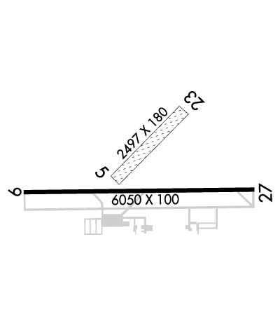
| Rwy | Rwy | |||||||
| 2267x180 | 2267' | 2267x180 | 2267' | |||||
| 6050x100 | 6050' | 6050x100 | 6050' | 108.30 - 273° | ||||
| Runway ID | Single Wheel | Double Wheel | Double Tandem Wheel | Dual Double Wheel |
| 05/23 | N/A | N/A | N/A | N/A |
| 09/27 | 45,000 | 60,000 | 100,000 | N/A |
| These numbers are Advisory and are not limits. The Airport Manager should have more accurate Weight Limits | ||||
 Airport Diagram might not be current. | |
| Facility Name: | GOSHEN MUNI |
| City Name: | GOSHEN |
| County: | ELKHART |
| State abbrev: | IN |
| State Name: | INDIANA |
| Ownership: | PUBLICLY OWNED |
| Use: | OPEN TO THE PUBLIC |
| Owner's Name: | GOSHEN BOAC |
| Address: | 202 S 5TH ST |
| GOSHEN, IN 46526 | |
| Owner's Phone: | (574) 533-8245 |
| Manager's Name: | RANDY SHARKEY |
| Address: | 17229 CR 42 |
| GOSHEN, IN 46526 | |
| Phone: | 574-533-8245; OR 574-538-8179. ALSO, A 24-HR PHONE AVBL. |
| FAA Region: | GREAT LAKES |
| FAA Field Office: | CHI |
| Date | Sunrise | Sunset |
|---|---|---|
| 09/24/21 Friday | 7:32 | 19:37 |
| 09/25/21 Saturday | 7:33 | 19:36 |
| 09/26/21 Sunday | 7:34 | 19:34 |
| 09/27/21 Monday | 7:36 | 19:32 |
| 09/28/21 Tuesday | 7:37 | 19:30 |
| 09/29/21 Wednesday | 7:38 | 19:29 |
| 09/30/21 Thursday | 7:39 | 19:27 |
| 10/01/21 Friday | 7:40 | 19:25 |
| 10/02/21 Saturday | 7:41 | 19:24 |
| 10/03/21 Sunday | 7:42 | 19:22 |
| 10/04/21 Monday | 7:43 | 19:20 |
| 10/05/21 Tuesday | 7:44 | 19:19 |
| 10/06/21 Wednesday | 7:45 | 19:17 |
| 10/07/21 Thursday | 7:46 | 19:15 |
| Airport Attendance Schedule | MON-SAT 0700-1800, SUN 0900-1700 |
| Airport Status | OPERATIONAL (This Status can change at any time - please check NOTAMS) |
| Airport Lighting Schedule | HIRL RY 09/27 PRESET LOW INTST; TO INCR INTST & ACTVT REIL RYS 09 & 27, PAPI RYS 09 & 27 - CTAF. |
| Airport Storage Available | Tie Downs, Hanger |
| Extra Services Available | Air Freight, Cargo Handling, Charter, Flight Instruction, Aircraft Rental |
| Wind Indicator | YES - (lighted) |
| Control Tower | NO |
| CTAF Frequency | 123.050 |
| Unicom Frequency | 123.050 |
| Rotating Beacon Color | CLEAR-GREEN (Light Land Airport) |
| Segmented Circle | NO |
| Landing Fee | NO |
| Airport Inspected | STATE - performed by STATE AERONAUTICAL PERSONNEL |
| Inspection Date | 10/08/2020 |
| Type of Fuel Available | Grade 100LL, JET A (freeze point -40C) |
| Airframe Repair Service | MAJOR |
| Power Plant Repair Service | MAJOR |
| Latitude | N4131.6 |
| Longitude | W08547.7 (ESTIMATED) |
| Arpt Elevation | 826ft (SURVEYED) |
| Magnetic Variation | 04W |
| 3 miles SE | of GOSHEN |
| Traffic Pattern Altitude | |
| Sectional Chart | CHICAGO |
| Operations (Reported) | Yearly | Avg. Daily |
|---|---|---|
| General Aviation Transient | 4922 | 13 |
| General Aviation Local | 15833 | 43 |
| Air Taxi | 642 | 2 |
| Commerical | 0 | 0 |
| Commuter | 0 | 0 |
| Military | 0 | 0 |
| Aircraft based on Field | |
|---|---|
| General Aviation Singles | 46 |
| General Aviation Multi | 8 |
| Jet Aircraft | 9 |
| General Aviation Helicopters | 6 |
| Military Aircraft | 0 |
| Gliders | 0 |
| Ultralights | 0 |
| FSS on field | NO |
| FSS tie-in | TERRE HAUTE |
| FSS Phone | 1-800-WX-BRIEF |
| Who issues Notams | GSH |
| Notam D service at airport | YES |
| ARTCC Name | CHICAGO |
| Airport Certification | |
| Aircraft Rescue & Firefighting Index | None |
| Airport of Entry | No |
| Custom Landing Rights | No |
| Joint Civil/Military | No |
| Military Landing rights | YES |
| NATIONAL PLAN OF INTEGRATED AIRPORT SYSTEMS (NPIAS) |
| GRANT AGREEMENTS UNDER FAAP/ADAP/AIP |
| ASSURANCES PURSUANT TO TITLE VI, CIVIL RIGHTS ACT OF 1964 |
Airport Communications & Frequencies:
| |||||||||||||||||||
| Runway: 05 | Runway: 23 | ||
| Mag heading: | 48° | Mag heading: | 228° |
| Rwy Slope: | .36% Up | Rwy Slope: | -.36% Down |
| Approach: | Approach: | ||
| Pattern: | Left Traffic | Pattern: | Left Traffic |
| Markings: | Markings: | ||
| Marking Condition: | RY 05 & 23 HAS YELLOW CONES. | Marking Condition: | |
| Arresting Dev: | Arresting Dev: | ||
| Lat & Long: | N4131.6 W08547.8 | Lat. & Long.: | N4131.8 W08547.4 |
| Elev: | 814.1 ft. MSL | Elev: | 822.3 ft. MSL |
| TCH: | TCH: | ||
| Visual Glide Path: | Visual Glide Path: | ||
| Displaced Threshold: | No | Displaced Threshold: | No |
| Touchdown Zone: | YES | Touchdown Zone: | YES |
| Touchdown Elev.: | 822.3 feet | Touchdown Elev.: | 822.3 feet |
| Visual Glide Slope: | Visual Glide Slope: | ||
| RVR Equipment: | RVR Equipment: | ||
| RVV Equipment: | NO | RVV Equipment: | NO |
| Approach Lights: | Approach Lights: | ||
| REIL: | NO | REIL: | NO |
| Centerline Lights: | NO | Centerline Lights: | NO |
| Touchdown lights: | NO | Touchdown lights: | NO |
| Runway Category: | Runway with a Visual Approach | Runway Category: | Runway with a Visual Approach |
| Declared Distances: | Declared Distances: | ||
| Obstructions: | Obstructions: | PLINE | |
| Marked: | Marked: | NOT Marked/Lighted | |
| Clearance slope: | 20:1 | Clearance slope: | 38:1 |
| Obstruction height: | Obstruction height: | 105 feet AGL | |
| Dist. from runway: | Dist. from runway: | 4020 feet | |
| Centerline offset: | Centerline offset: | ||
| Comments: | Comments: |
| Runway: 09 | Runway: 27 | ||
| Mag heading: | 93° | Mag heading: | 273° |
| Rwy Slope: | .11% Up | Rwy Slope: | -.11% Down |
| Approach: | Approach: | ILS | |
| Pattern: | Left Traffic | Pattern: | Left Traffic |
| Markings: | NONPRECISION INSTRUMENT | Markings: | PRECISION INSTRUMENT |
| Marking Condition: | FAIR | Marking Condition: | FAIR |
| Arresting Dev: | Arresting Dev: | ||
| Lat & Long: | N4131.5 W08548.3 | Lat. & Long.: | N4131.5 W08547.0 |
| Elev: | 819.6 ft. MSL | Elev: | 826.4 ft. MSL |
| TCH: | 40 ft. AGL | TCH: | 51 ft. AGL |
| Visual Glide Path: | 3.50 degrees | Visual Glide Path: | 3.00 degrees |
| Displaced Threshold: | No | Displaced Threshold: | No |
| Touchdown Zone: | YES | Touchdown Zone: | YES |
| Touchdown Elev.: | 820.4 feet | Touchdown Elev.: | 826.6 feet |
| Visual Glide Slope: | 2-Light PAPI on LEFT side of Runway | Visual Glide Slope: | 4-Light PAPI on LEFT side of Runway |
| RVR Equipment: | RVR Equipment: | ||
| RVV Equipment: | NO | RVV Equipment: | NO |
| Approach Lights: | Approach Lights: | ||
| REIL: | YES | REIL: | YES |
| Centerline Lights: | NO | Centerline Lights: | NO |
| Touchdown lights: | NO | Touchdown lights: | NO |
| Runway Category: | Runway with a Non-precision Approach having visibility minimums greater than 3/4 mile | Runway Category: | Precision Instrument Runway |
| Declared Distances: | Declared Distances: | ||
| Obstructions: | TREE | Obstructions: | TREE |
| Marked: | NOT Marked/Lighted | Marked: | NOT Marked/Lighted |
| Clearance slope: | 30:1 | Clearance slope: | 44:1 |
| Obstruction height: | 59 feet AGL | Obstruction height: | 83 feet AGL |
| Dist. from runway: | 1976 feet | Dist. from runway: | 3630 feet |
| Centerline offset: | 117 right of centerline | Centerline offset: | 210 feet right of centerline |
| Comments: | Comments: |
Thanks for using FltPlan.com
all rights reserved © 1999-2021 by Flight Plan LLC
