
| GORDON MUNI GORDON NE |
| |
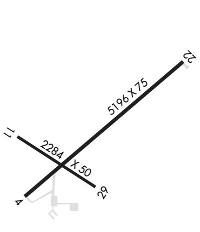
| Lat: N 4248.4 Long: W 10210.5 Elev: 3562 Var: -09 Longest Runway: 5196 | ||
| CTAF: 122.8 | ||
| ||||||
|
| Rwy | Rwy | |||||||
| 5196x75 | 5196' | 5196x75 | 5196' | |||||
| 2284x50 | 2284' | 2284x50 | 2284' | |||||
| Runway ID | Single Wheel | Double Wheel | Double Tandem Wheel | Dual Double Wheel |
| 04/22 | 12,000 | N/A | N/A | N/A |
| 11/29 | 12,000 | N/A | N/A | N/A |
| These numbers are Advisory and are not limits. The Airport Manager should have more accurate Weight Limits | ||||
 Airport Diagram might not be current. | |
| Facility Name: | GORDON MUNI |
| City Name: | GORDON |
| County: | SHERIDAN |
| State abbrev: | NE |
| State Name: | NEBRASKA |
| Ownership: | PUBLICLY OWNED |
| Use: | OPEN TO THE PUBLIC |
| Owner's Name: | GORDON ARPT AUTH; MARK KRUGER (605) 840-0177. |
| Address: | PO BOX 310 |
| GORDON, NE 69343-0310 | |
| Owner's Phone: | 308-360-0746 |
| Manager's Name: | GLENN SPAUGH |
| Address: | PO BOX 310 |
| GORDON, NE 69343-0310 | |
| Phone: | 308-282-0837 |
| FAA Region: | CENTRAL |
| FAA Field Office: | NONE |
| Date | Sunrise | Sunset |
|---|---|---|
| 09/24/21 Friday | 6:38 | 18:43 |
| 09/25/21 Saturday | 6:39 | 18:41 |
| 09/26/21 Sunday | 6:40 | 18:39 |
| 09/27/21 Monday | 6:41 | 18:37 |
| 09/28/21 Tuesday | 6:42 | 18:36 |
| 09/29/21 Wednesday | 6:43 | 18:34 |
| 09/30/21 Thursday | 6:45 | 18:32 |
| 10/01/21 Friday | 6:46 | 18:30 |
| 10/02/21 Saturday | 6:47 | 18:29 |
| 10/03/21 Sunday | 6:48 | 18:27 |
| 10/04/21 Monday | 6:49 | 18:25 |
| 10/05/21 Tuesday | 6:50 | 18:23 |
| 10/06/21 Wednesday | 6:51 | 18:22 |
| 10/07/21 Thursday | 6:52 | 18:20 |
| Airport Attendance Schedule | MON-FRI 0800-1700; FOR SVC AFTER HRS CALL 308-360-1906 OR 308-360-2120. |
| Airport Status | OPERATIONAL (This Status can change at any time - please check NOTAMS) |
| Airport Lighting Schedule | ACTVT MIRL RWY 4/22 & 11/29 - CTAF; PAPI RWY 04 & 22 ON 24 HRS. |
| Airport Storage Available | Tie Downs, Hanger |
| Extra Services Available | Flight Instruction |
| Wind Indicator | YES - (lighted) |
| Control Tower | NO |
| CTAF Frequency | 122.800 |
| Unicom Frequency | 122.800 |
| Rotating Beacon Color | CLEAR-GREEN (Light Land Airport) |
| Segmented Circle | NO |
| Landing Fee | NO |
| Airport Inspected | STATE - performed by STATE AERONAUTICAL PERSONNEL |
| Inspection Date | 06/23/2020 |
| Type of Fuel Available | Grade 100LL; -10AVGAS AVBL. |
| Airframe Repair Service | None |
| Power Plant Repair Service | None |
| Latitude | N4248.4 |
| Longitude | W10210.5 (ESTIMATED) |
| Arpt Elevation | 3562ft (SURVEYED) |
| Magnetic Variation | 09E |
| 1 miles E | of GORDON |
| Traffic Pattern Altitude | |
| Sectional Chart | CHEYENNE |
| Operations (Reported) | Yearly | Avg. Daily |
|---|---|---|
| General Aviation Transient | 600 | 2 |
| General Aviation Local | 900 | 2 |
| Air Taxi | 0 | 0 |
| Commerical | 0 | 0 |
| Commuter | 0 | 0 |
| Military | 0 | 0 |
| Aircraft based on Field | |
|---|---|
| General Aviation Singles | 11 |
| General Aviation Multi | 1 |
| Jet Aircraft | 0 |
| General Aviation Helicopters | 0 |
| Military Aircraft | 0 |
| Gliders | 0 |
| Ultralights | 0 |
| FSS on field | NO |
| FSS tie-in | COLUMBUS |
| FSS Phone | 1-800-WX-BRIEF |
| Who issues Notams | OLU |
| Notam D service at airport | YES |
| ARTCC Name | DENVER |
| Airport Certification | |
| Aircraft Rescue & Firefighting Index | None |
| Airport of Entry | No |
| Custom Landing Rights | No |
| Joint Civil/Military | No |
| Military Landing rights | YES |
| NATIONAL PLAN OF INTEGRATED AIRPORT SYSTEMS (NPIAS) |
| GRANT AGREEMENTS UNDER FAAP/ADAP/AIP |
| ASSURANCES PURSUANT TO TITLE VI, CIVIL RIGHTS ACT OF 1964 |
| FOR CD CTC DENVER ARTCC AT 303-651-4257. |
| RWY 11/2 9 MARKINGS FADED. |
| RWY 11/2 9 WEEDS IN PAVEMENT; MED & HIGH SEVERITY CRACKS IN PAVEMENT. |
Airport Communications & Frequencies:
| |||||||||
| Runway: 04 | Runway: 22 | ||
| Mag heading: | 40° | Mag heading: | 220° |
| Rwy Slope: | .36% Up | Rwy Slope: | -.36% Down |
| Approach: | Approach: | ||
| Pattern: | Left Traffic | Pattern: | Left Traffic |
| Markings: | NONPRECISION INSTRUMENT | Markings: | NONPRECISION INSTRUMENT |
| Marking Condition: | GOOD | Marking Condition: | GOOD |
| Arresting Dev: | Arresting Dev: | ||
| Lat & Long: | N4248.1 W10210.9 | Lat. & Long.: | N4248.7 W10210.0 |
| Elev: | 3543.5 ft. MSL | Elev: | 3562.1 ft. MSL |
| TCH: | 39 ft. AGL | TCH: | 39 ft. AGL |
| Visual Glide Path: | 3.00 degrees | Visual Glide Path: | 3.00 degrees |
| Displaced Threshold: | No | Displaced Threshold: | No |
| Touchdown Zone: | YES | Touchdown Zone: | YES |
| Touchdown Elev.: | 3545.3 feet | Touchdown Elev.: | 3562.1 feet |
| Visual Glide Slope: | 2-Light PAPI on LEFT side of Runway | Visual Glide Slope: | 2-Light PAPI on LEFT side of Runway |
| RVR Equipment: | RVR Equipment: | ||
| RVV Equipment: | NO | RVV Equipment: | NO |
| Approach Lights: | Approach Lights: | ||
| REIL: | NO | REIL: | NO |
| Centerline Lights: | NO | Centerline Lights: | NO |
| Touchdown lights: | NO | Touchdown lights: | NO |
| Runway Category: | Runway with a Non-precision Approach | Runway Category: | Runway with a Non-precision Approach |
| Declared Distances: | Declared Distances: | ||
| Obstructions: | TREES | Obstructions: | ROAD |
| Marked: | NOT Marked/Lighted | Marked: | NOT Marked/Lighted |
| Clearance slope: | 17:1 | Clearance slope: | 22:1 |
| Obstruction height: | 57 feet AGL | Obstruction height: | 21 feet AGL |
| Dist. from runway: | 1213 feet | Dist. from runway: | 673 feet |
| Centerline offset: | 197 right of centerline | Centerline offset: | |
| Comments: | Comments: |
| Runway: 11 | Runway: 29 | ||
| Mag heading: | 114° | Mag heading: | 294° |
| Rwy Slope: | -.30% Down | Rwy Slope: | .30% Up |
| Approach: | Approach: | ||
| Pattern: | Left Traffic | Pattern: | Left Traffic |
| Markings: | BASIC | Markings: | BASIC |
| Marking Condition: | FAIR | Marking Condition: | FAIR |
| Arresting Dev: | Arresting Dev: | ||
| Lat & Long: | N4248.4 W10210.9 | Lat. & Long.: | N4248.2 W10210.5 |
| Elev: | 3548.9 ft. MSL | Elev: | 3542.1 ft. MSL |
| TCH: | TCH: | ||
| Visual Glide Path: | Visual Glide Path: | ||
| Displaced Threshold: | No | Displaced Threshold: | No |
| Touchdown Zone: | YES | Touchdown Zone: | YES |
| Touchdown Elev.: | 3548.9 feet | Touchdown Elev.: | 3548.9 feet |
| Visual Glide Slope: | Visual Glide Slope: | ||
| RVR Equipment: | RVR Equipment: | ||
| RVV Equipment: | NO | RVV Equipment: | NO |
| Approach Lights: | Approach Lights: | ||
| REIL: | NO | REIL: | NO |
| Centerline Lights: | NO | Centerline Lights: | NO |
| Touchdown lights: | NO | Touchdown lights: | NO |
| Runway Category: | Runway with a Visual Approach | Runway Category: | Runway with a Visual Approach |
| Declared Distances: | Declared Distances: | ||
| Obstructions: | ROAD | Obstructions: | FENCE |
| Marked: | NOT Marked/Lighted | Marked: | NOT Marked/Lighted |
| Clearance slope: | 15:1 | Clearance slope: | 7:1 |
| Obstruction height: | 15 feet AGL | Obstruction height: | 3 feet AGL |
| Dist. from runway: | 433 feet | Dist. from runway: | 222 feet |
| Centerline offset: | Centerline offset: | 127 feet right of centerline | |
| Comments: | Comments: |
Thanks for using FltPlan.com
all rights reserved © 1999-2021 by Flight Plan LLC
