
| CENTRAL NEBRASKA RGNL GRAND ISLAND NE |
| |
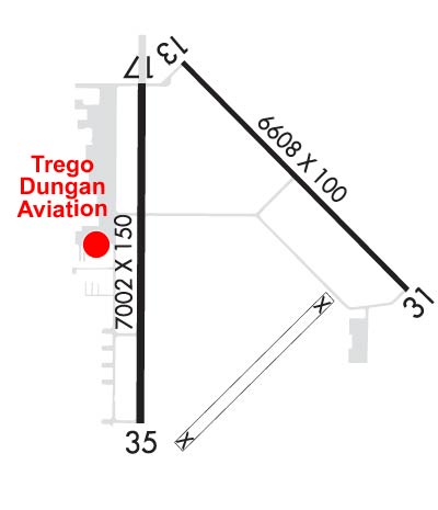
| Lat: N 4058.1 Long: W 09818.6 Elev: 1847 Var: -07 Longest Runway: 7002 | ||
| Clr Del: 121.9 Dept. ATIS: 127.4 Arr. ATIS: 127.4 AWOS: 127.4 Ground: 121.9 Tower: 118.2 | ||
| ||||||||||||||||||||||||||||||
| ||||||||||||||||||||||||||||||
| ||||||||||||||||||||||||||||||
| Rwy | Rwy | |||||||
| 6608x100 | 6608' | 6608x100 | 6608' | |||||
| 7002x150 | 7002' | 7002x150 | 7002' | 111.90 - 353° | ||||
| Runway ID | Single Wheel | Double Wheel | Double Tandem Wheel | Dual Double Wheel |
| 13/31 | 45,000 | 59,000 | N/A | N/A |
| 17/35 | 75,000 | 110,000 | 185,000 | N/A |
| These numbers are Advisory and are not limits. The Airport Manager should have more accurate Weight Limits | ||||
 Airport Diagram might not be current. | |
| Facility Name: | CENTRAL NEBRASKA RGNL |
| City Name: | GRAND ISLAND |
| County: | HALL |
| State abbrev: | NE |
| State Name: | NEBRASKA |
| Ownership: | PUBLICLY OWNED |
| Use: | OPEN TO THE PUBLIC |
| Owner's Name: | HALL COUNTY ARPT AUTH |
| Address: | 3579 SKY PARK ROAD |
| GRAND ISLAND, NE 68801 | |
| Owner's Phone: | 308-385-5170 |
| Manager's Name: | MR. MICHAEL OLSON, A.A.E. |
| Address: | 3855 SKY PARK ROAD |
| GRAND ISLAND, NE 68801 | |
| Phone: | 308-385-5170; OR 308-385-5172. |
| FAA Region: | CENTRAL |
| FAA Field Office: | NONE |
| Date | Sunrise | Sunset |
|---|---|---|
| 09/24/21 Friday | 7:22 | 19:27 |
| 09/25/21 Saturday | 7:24 | 19:26 |
| 09/26/21 Sunday | 7:25 | 19:24 |
| 09/27/21 Monday | 7:26 | 19:22 |
| 09/28/21 Tuesday | 7:27 | 19:21 |
| 09/29/21 Wednesday | 7:28 | 19:19 |
| 09/30/21 Thursday | 7:29 | 19:17 |
| 10/01/21 Friday | 7:30 | 19:16 |
| 10/02/21 Saturday | 7:31 | 19:14 |
| 10/03/21 Sunday | 7:32 | 19:12 |
| 10/04/21 Monday | 7:33 | 19:11 |
| 10/05/21 Tuesday | 7:34 | 19:09 |
| 10/06/21 Wednesday | 7:35 | 19:07 |
| 10/07/21 Thursday | 7:36 | 19:06 |
| Airport Attendance Schedule | CONTINUOUS |
| Airport Status | OPERATIONAL (This Status can change at any time - please check NOTAMS) |
| Airport Lighting Schedule | ACTVT PAPI RWY 31 & 35 - CTAF. WHEN TWR CLSD ACTVT MALS RWY 13 & 17; MALSR RWY 35; REIL RWY 31; PAPI RWY 13 & 17; MIRL RWY 13/31; HIRL RWY 17/35 - CTAF. |
| Airport Storage Available | Tie Downs, Hanger |
| Extra Services Available | Air Freight, Air Ambulance, Avionics, Cargo Handling, Charter, Flight Instruction |
| Wind Indicator | YES - (lighted) |
| Control Tower | YES |
| CTAF Frequency | 118.200 |
| Unicom Frequency | 122.950 |
| Rotating Beacon Color | CLEAR-GREEN (Light Land Airport) |
| Segmented Circle | NO |
| Landing Fee | NO |
| Airport Inspected | FEDERAL - performed by FAA AIRPORTS FIELD PERSONNEL |
| Inspection Date | 08/16/2019 |
| Type of Fuel Available | Grade 100LL, JET A (freeze point -40C) |
| Airframe Repair Service | MAJOR |
| Power Plant Repair Service | MAJOR |
| Latitude | N4058.1 |
| Longitude | W09818.6 (ESTIMATED) |
| Arpt Elevation | 1847ft (ESTIMATED) |
| Magnetic Variation | 07E |
| 3 miles NE | of GRAND ISLAND |
| Traffic Pattern Altitude | |
| Sectional Chart | OMAHA |
| Operations (Reported) | Yearly | Avg. Daily |
|---|---|---|
| General Aviation Transient | 7925 | 22 |
| General Aviation Local | 4750 | 13 |
| Air Taxi | 2712 | 7 |
| Commerical | 448 | 1 |
| Commuter | 0 | 0 |
| Military | 1444 | 4 |
| Aircraft based on Field | |
|---|---|
| General Aviation Singles | 23 |
| General Aviation Multi | 3 |
| Jet Aircraft | 2 |
| General Aviation Helicopters | 0 |
| Military Aircraft | 10 |
| Gliders | 0 |
| Ultralights | 0 |
| FSS on field | NO |
| FSS tie-in | FORT WORTH |
| FSS Phone | 1-800-WX-BRIEF |
| Who issues Notams | GRI |
| Notam D service at airport | YES |
| ARTCC Name | MINNEAPOLIS |
| Airport Certification | AIRPORT RECEIVING SCHEDULED AIR CARRIER SERVICE FROM CARRIERS CERTIFICATED BY THE CIVIL AERONAUTICS BOARD; PPR 24 HRS FOR UNSKED ACR OPNS WITH MORE THAN 30 PSGR SEATS CALL AMGR (308) 385-5170. INDEX C LEVEL ARFF IS AVBL UPON REQUEST. ACR OPNS OVER 9 PSGR SEATS NOT AUTHORIZED IN EXCESS OF 15 MINS BEFORE OR AFT SKED ARR/DEP TIMES EXCEPT WITH PRIOR COORDINATION WITH AMGR. |
| Aircraft Rescue & Firefighting Index | AIRPORT HAS A CERTIFICATE UNDER CFR PART 139 |
| Airport of Entry | No |
| Custom Landing Rights | No |
| Joint Civil/Military | No |
| Military Landing rights | YES |
| NATIONAL PLAN OF INTEGRATED AIRPORT SYSTEMS (NPIAS) |
| GRANT AGREEMENTS UNDER FAAP/ADAP/AIP |
| SURPLUS PROPERTY AGREEMENT UNDER PUBLIC LAW 289 |
| ASSURANCES PURSUANT TO TITLE VI, CIVIL RIGHTS ACT OF 1964 |
| AGREEMENT UNDER DLAND OR DCLA HAS EXPIRED. |
| THIS AIRPORT HAS BEEN SURVEYED BY THE NATIONAL GEODETIC SURVEY. |
| COMPRESSED NITROGEN FOR STRUT INFLATION AVBL. |
| INBOUND ACFT CTC OPS 10 MIN PRIOR TO LNDG. |
| ARNG: OPR 0730-1600++MON-FRI; OCNL WKEND. PPR TO PRK ARNG RAMP. DSN 279-8691, C402-309-8691. |
| MIGRATORY WATERFOWL ON & INVOF ARPT. |
| TWY DELTA EXIT OFF RY 17/35 CLSD TO LARGE ACFT DUE TO INADEQUATE TURNING RADIUS. |
Airport Communications & Frequencies:
| |||||||||||||||||||||
| Runway: 13 | Runway: 31 | ||
| Mag heading: | 128° | Mag heading: | 308° |
| Rwy Slope: | .05% Up | Rwy Slope: | -.05% Down |
| Approach: | Approach: | ||
| Pattern: | Left Traffic | Pattern: | Left Traffic |
| Markings: | NONPRECISION INSTRUMENT | Markings: | NONPRECISION INSTRUMENT |
| Marking Condition: | GOOD | Marking Condition: | GOOD |
| Arresting Dev: | Arresting Dev: | ||
| Lat & Long: | N4058.7 W09818.7 | Lat. & Long.: | N4057.9 W09817.7 |
| Elev: | 1840.0 ft. MSL | Elev: | 1843.0 ft. MSL |
| TCH: | 35 ft. AGL | TCH: | 42 ft. AGL |
| Visual Glide Path: | 3.00 degrees | Visual Glide Path: | 3.00 degrees |
| Displaced Threshold: | No | Displaced Threshold: | No |
| Touchdown Zone: | YES | Touchdown Zone: | YES |
| Touchdown Elev.: | 1842.4 feet | Touchdown Elev.: | 1843.7 feet |
| Visual Glide Slope: | 4-Light PAPI on LEFT side of Runway | Visual Glide Slope: | 4-Light PAPI on LEFT side of Runway |
| RVR Equipment: | RVR Equipment: | ||
| RVV Equipment: | NO | RVV Equipment: | NO |
| Approach Lights: | MALS - 1,400 foot medium intensity approach lighting system | Approach Lights: | |
| REIL: | NO | REIL: | YES |
| Centerline Lights: | NO | Centerline Lights: | NO |
| Touchdown lights: | NO | Touchdown lights: | NO |
| Runway Category: | D | Runway Category: | Runway with a Non-precision Approach having visibility minimums greater than 3/4 mile |
| Declared Distances: | TORA:6608' TODA:6608' ASDA:6608' LDA:6608' | Declared Distances: | TORA:6608' TODA:6608' ASDA:6608' LDA:6608' |
| Runway: 17 | Runway: 35 | ||
| Mag heading: | 173° | Mag heading: | 353° |
| Rwy Slope: | .04% Up | Rwy Slope: | -.04% Down |
| Approach: | Approach: | ILS | |
| Pattern: | Left Traffic | Pattern: | Left Traffic |
| Markings: | NONPRECISION INSTRUMENT | Markings: | PRECISION INSTRUMENT |
| Marking Condition: | GOOD | Marking Condition: | GOOD |
| Arresting Dev: | Arresting Dev: | ||
| Lat & Long: | N4058.6 W09818.9 | Lat. & Long.: | N4057.5 W09818.9 |
| Elev: | 1843.7 ft. MSL | Elev: | 1846.7 ft. MSL |
| TCH: | 38 ft. AGL | TCH: | 55 ft. AGL |
| Visual Glide Path: | 3.00 degrees | Visual Glide Path: | 2.60 degrees |
| Displaced Threshold: | No | Displaced Threshold: | No |
| Touchdown Zone: | YES | Touchdown Zone: | YES |
| Touchdown Elev.: | 1844.1 feet | Touchdown Elev.: | 1846.8 feet |
| Visual Glide Slope: | 4-Light PAPI on LEFT side of Runway | Visual Glide Slope: | 4-Light PAPI on LEFT side of Runway; PAPI RESTRICTED BYD 6 DEG RIGHT OF CNTRL. |
| RVR Equipment: | ROLLOUT | RVR Equipment: | TOUCHDOWN |
| RVV Equipment: | NO | RVV Equipment: | NO |
| Approach Lights: | MALS - 1,400 foot medium intensity approach lighting system | Approach Lights: | MALSR - 1,400 foot medium intensity approach lighting system with runway alignment indicator lights |
| REIL: | NO | REIL: | NO |
| Centerline Lights: | NO | Centerline Lights: | NO |
| Touchdown lights: | NO | Touchdown lights: | NO |
| Runway Category: | D | Runway Category: | Precision Instrument Runway |
| Declared Distances: | TORA:7002' TODA:7002' ASDA:7002' LDA:7002' | Declared Distances: | TORA:7002' TODA:7002' ASDA:7002' LDA:7002' |
Thanks for using FltPlan.com
all rights reserved © 1999-2021 by Flight Plan LLC