
| GRAY AAF (JOINT BASE LEWIS-MCC FORT LEWIS/TACOMA WA |
| |
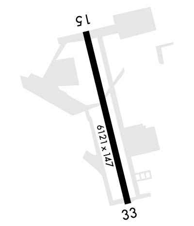
| Lat: N 4704.8 Long: W 12234.8 Elev: 301 Var: -16 Longest Runway: 6124 | ||
| Clr Del: 121.9 Dept. ATIS: 124.65 Arr. ATIS: 124.65 Ground: 121.9 Tower: 119.32 | ||
| ||||||||||||||||||||||||||||||||
| ||||||||||||||||||||||||||||||||
| ||||||||||||||||||||||||||||||||
| Rwy | Rwy | |||||||
| 6124x150 | 6124' | 108.30 - 151° | 6124x150 | 6124' | ||||
| Runway ID | Single Wheel | Double Wheel | Double Tandem Wheel | Dual Double Wheel |
| 15/33 | N/A | N/A | N/A | N/A |
| H2 | N/A | N/A | N/A | N/A |
| H3 | N/A | N/A | N/A | N/A |
| H4 | N/A | N/A | N/A | N/A |
| These numbers are Advisory and are not limits. The Airport Manager should have more accurate Weight Limits | ||||
 Airport Diagram might not be current. | |
| Facility Name: | GRAY AAF (JOINT BASE LEWIS-MCCHORD) |
| City Name: | FORT LEWIS/TACOMA |
| County: | PIERCE |
| State abbrev: | WA |
| State Name: | WASHINGTON |
| Ownership: | ARMY OWNED |
| Use: | PRIVATE |
| Owner's Name: | US ARMY AERONAUTICAL SVCS AGENCY |
| Address: | |
| FT BELVOIR, VA 22060 | |
| Owner's Phone: | 703 806 4864 |
| Manager's Name: | NATHAN QUICK |
| Address: | |
| Phone: | 253 967 6628; OTR CTC: 253-967-6676. |
| FAA Region: | NORTHWEST MOUNTAIN |
| FAA Field Office: | SEA |
| Date | Sunrise | Sunset |
|---|---|---|
| 06/07/26 Sunday | 5:16 | 21:03 |
| 06/08/26 Monday | 5:16 | 21:03 |
| 06/09/26 Tuesday | 5:15 | 21:04 |
| 06/10/26 Wednesday | 5:15 | 21:05 |
| 06/11/26 Thursday | 5:15 | 21:05 |
| 06/12/26 Friday | 5:15 | 21:06 |
| 06/13/26 Saturday | 5:14 | 21:06 |
| 06/14/26 Sunday | 5:14 | 21:07 |
| 06/15/26 Monday | 5:14 | 21:07 |
| 06/16/26 Tuesday | 5:14 | 21:08 |
| 06/17/26 Wednesday | 5:14 | 21:08 |
| 06/18/26 Thursday | 5:14 | 21:09 |
| 06/19/26 Friday | 5:14 | 21:09 |
| 06/20/26 Saturday | 5:15 | 21:09 |
| Airport Attendance Schedule | CONTINUOUS |
| Airport Status | OPERATIONAL (This Status can change at any time - please check NOTAMS) |
| Airport Lighting Schedule | |
| Airport Storage Available | NONE |
| Extra Services Available | NONE |
| Wind Indicator | YES - (unlit) |
| Control Tower | YES |
| CTAF Frequency | 119.325 |
| Unicom Frequency | |
| Rotating Beacon Color | SWG |
| Segmented Circle | NO |
| Landing Fee |
| Airport Inspected | No Inspection Data Available performed by the OWNER |
| Inspection Date | Unknown |
| Type of Fuel Available | ++; -A+MIL; LTD SUPPLY; NATO F24 AVBL; TRANS ALERT 1400-2200++. |
| Airframe Repair Service | None |
| Power Plant Repair Service | None |
| Latitude | N4704.8 |
| Longitude | W12234.8 (ESTIMATED) |
| Arpt Elevation | 301ft (SURVEYED) |
| Magnetic Variation | 16E |
| 1 miles E | of FORT LEWIS/TACOMA |
| Traffic Pattern Altitude | E/W TFC, F/W 1800 FT, R/W 800 FT. |
| Sectional Chart | SEATTLE |
| Operations (Reported) | Yearly | Avg. Daily |
|---|---|---|
| General Aviation Transient | 0 | 0 |
| General Aviation Local | 0 | 0 |
| Air Taxi | 0 | 0 |
| Commerical | 0 | 0 |
| Commuter | 0 | 0 |
| Military | 0 | 0 |
| Aircraft based on Field | |
|---|---|
| General Aviation Singles | 0 |
| General Aviation Multi | 0 |
| Jet Aircraft | 0 |
| General Aviation Helicopters | 0 |
| Military Aircraft | 0 |
| Gliders | 0 |
| Ultralights | 0 |
| FSS on field | NO |
| FSS tie-in | SEATTLE |
| FSS Phone | 1-800-WX-BRIEF |
| Who issues Notams | GRF |
| Notam D service at airport | YES |
| ARTCC Name | SEATTLE |
| Airport Certification | |
| Aircraft Rescue & Firefighting Index | None |
| Airport of Entry | No |
| Custom Landing Rights | No |
| Joint Civil/Military | No |
| Military Landing rights | No |
| SEE FLIP AP/1 SUPPLEMENTARY ARPT |
| RSTD: 72 HR PPR TRAN ACFT. NO TRAN ACFT WKEND & HOL. |
| PJE INVOF ARPT. |
| MISC: SVFR DAY F/W 700-1, R/W 300- 1/2. NGT F/W NA, R/W 500-1. TACTICAL OPS ON JBLM MIL RSVN - CTC OPS PRIOR. CTC GRAY TFC ON CTAF WHEN TWR CLSD. CLASS D ASP WHEN ATCT OPEN; OTR TIMES CLASS E. TSNT HNGR NA. BASE OPS, TWR & WX MON-FRI H24; CLSD WKEND; CLSD HOL. |
| AR - CTC USAR OPS - D357-6628/C253-967-6628. |
| ARNG: OPR 1430-0100Z++ TUE-FRI EXC HOL. TRAN ALERT SVC NA. |
| CTN: NON RDO PAEW ON GND CTL XNG TWY G & H. |
| BULLSEYE RDO OPR MON-FRI H24; CLSD WKND CLSD HOL. R/W CTC BULLSEYE RDO PRIOR TO ENTRY R6703A-J - 34.6 141.5 379.1. RANGE STATUS - 384.525 & 142.7. |
| MISC: ADD RCR RPTD MON-FR 0700-1500 VIA NOTAM & ATIS DURG INCLEMENT WINTER WX. |
| NGT VISION TRNG ON ARPT; LGT MAY BE DIM OR OFF; R/W CTC GRAY ATCT ON INITIAL CTC IF UNAIDED. |
| MISC: BASE OPS, ATCT, & WX MON-FRI H24. CLSD WKEND; CLSD HOL. NO SPACE A PAX PPR WITHOUT PRIOR COORDINATION WITH AF MANAGER. |
| NO DE-ICE |
| FOR CD WHEN ATCT IS CLSD CTC SEATTLE APCH AT 206-214-4723. 120.1/290.9. |
| SMALL ARMS RANGE 0.8 NM E. |
Airport Communications & Frequencies:
| |||||||||||||||||||||||||||||||||
| Runway: 15 | Runway: 33 | ||
| Mag heading: | N/A | Mag heading: | N/A |
| Rwy Slope: | .18% Up | Rwy Slope: | -.18% Down |
| Approach: | ILS/DME | Approach: | |
| Pattern: | Left Traffic | Pattern: | Left Traffic |
| Markings: | PRECISION INSTRUMENT | Markings: | PRECISION INSTRUMENT |
| Marking Condition: | GOOD | Marking Condition: | GOOD |
| Arresting Dev: | Arresting Dev: | ||
| Lat & Long: | N4705.2 W12235.0 | Lat. & Long.: | N4704.3 W12234.7 |
| Elev: | 289.2 ft. MSL | Elev: | 300.4 ft. MSL |
| TCH: | 58 ft. AGL | TCH: | |
| Visual Glide Path: | 3.00 degrees | Visual Glide Path: | |
| Displaced Threshold: | No | Displaced Threshold: | No |
| Touchdown Zone: | YES | Touchdown Zone: | YES |
| Touchdown Elev.: | 299.5 feet | Touchdown Elev.: | 301.0 feet |
| Visual Glide Slope: | 4-Light PAPI on LEFT side of Runway; PAPI RWY 15 UNUSBL BYD 8 DEGS RIGHT OF CNTRLN. | Visual Glide Slope: | |
| RVR Equipment: | TOUCHDOWN | RVR Equipment: | ROLLOUT |
| RVV Equipment: | NO | RVV Equipment: | NO |
| Approach Lights: | SSALR - simplified short approach lighting system with runway alignment indicator lights | Approach Lights: | SSALR - simplified short approach lighting system with runway alignment indicator lights |
| REIL: | NO | REIL: | NO |
| Centerline Lights: | NO | Centerline Lights: | NO |
| Touchdown lights: | NO | Touchdown lights: | NO |
| Runway Category: | Runway Category: | ||
| Declared Distances: | Declared Distances: | ||
| Obstructions: | TOWER | Obstructions: | |
| Marked: | LIGHTED | Marked: | |
| Clearance slope: | Clearance slope: | ||
| Obstruction height: | 114 feet AGL | Obstruction height: | |
| Dist. from runway: | 2613 feet | Dist. from runway: | 3528 feet |
| Centerline offset: | Centerline offset: | ||
| Comments: | Comments: |
Thanks for using FltPlan.com
all rights reserved © 1999-2026 by Flight Plan LLC
