
| AUSTIN STRAUBEL INTL GREEN BAY WI |
| |
| Lat: N 4429.1 Long: W 08807.8 Elev: 695 Var: +02 Longest Runway: 8700 | ||
| Clr Del: 121.75 Dept. ATIS: 124.1 Arr. ATIS: 124.1 Ground: 121.9 Tower: 118.7 | ||
| |||||||||||||||||||||||||||||||||||||||||||||||||||||||||||||||||||||
| |||||||||||||||||||||||||||||||||||||||||||||||||||||||||||||||||||||
| |||||||||||||||||||||||||||||||||||||||||||||||||||||||||||||||||||||
| |||||||||||||||||||||||||||||||||||||||||||||||||||||||||||||||||||||
| Rwy | Rwy | |||||||
| 7700x150 | 7700' | 109.50 - 061° | 7700x150 | 7700' | ||||
| 8700x150 | 8201' | 8700x150 | 8700' | 109.90 - 001° | ||||
| Runway ID | Single Wheel | Double Wheel | Double Tandem Wheel | Dual Double Wheel |
| 06/24 | 120,000 | 170,000 | 290,000 | N/A |
| 18/36 | 120,000 | 170,000 | 290,000 | N/A |
| These numbers are Advisory and are not limits. The Airport Manager should have more accurate Weight Limits | ||||
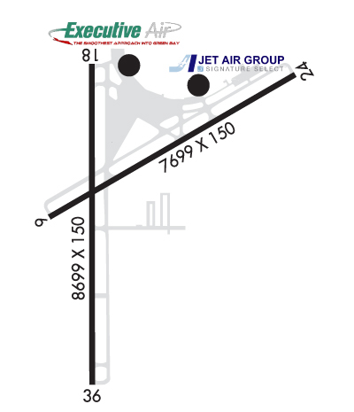 Airport Diagram might not be current. | |
| Facility Name: | GREEN BAY/AUSTIN STRAUBEL INTL |
| City Name: | GREEN BAY |
| County: | BROWN |
| State abbrev: | WI |
| State Name: | WISCONSIN |
| Ownership: | PUBLICLY OWNED |
| Use: | OPEN TO THE PUBLIC |
| Owner's Name: | BROWN COUNTY |
| Address: | 2077 AIRPORT DRIVE, STE #18 |
| GREEN BAY, WI 54313-5596 | |
| Owner's Phone: | 920-498-4800 |
| Manager's Name: | MARTY PIETTE |
| Address: | 2077 AIRPORT DRIVE |
| GREEN BAY, WI 54313-5596 | |
| Phone: | 920-498-4800 |
| FAA Region: | GREAT LAKES |
| FAA Field Office: | CHI |

| Date | Sunrise | Sunset |
|---|---|---|
| 06/08/26 Monday | 5:08 | 20:35 |
| 06/09/26 Tuesday | 5:08 | 20:36 |
| 06/10/26 Wednesday | 5:08 | 20:36 |
| 06/11/26 Thursday | 5:07 | 20:37 |
| 06/12/26 Friday | 5:07 | 20:37 |
| 06/13/26 Saturday | 5:07 | 20:38 |
| 06/14/26 Sunday | 5:07 | 20:38 |
| 06/15/26 Monday | 5:07 | 20:39 |
| 06/16/26 Tuesday | 5:07 | 20:39 |
| 06/17/26 Wednesday | 5:07 | 20:40 |
| 06/18/26 Thursday | 5:07 | 20:40 |
| 06/19/26 Friday | 5:07 | 20:40 |
| 06/20/26 Saturday | 5:08 | 20:41 |
| 06/21/26 Sunday | 5:08 | 20:41 |
| Airport Attendance Schedule | 7 Days A Week 0500-2200 |
| Airport Status | OPERATIONAL (This Status can change at any time - please check NOTAMS) |
| Airport Lighting Schedule | ACTVT MALSR RWY 06 & 36; REIL RWY 18; HIRL RWY 06/24 & 18/36 - CTAF. PAPI RWY 06, 18, 24 & 36 OPR CONSLY. WHEN ATCT CLSD PREFERRED RWY PRESET ON LOW OR MED INTST; INCR INTST - CTAF. |
| Airport Storage Available | Tie Downs, Hanger |
| Extra Services Available | NONE |
| Wind Indicator | YES - (lighted) |
| Control Tower | YES |
| CTAF Frequency | 118.700 |
| Unicom Frequency | |
| Rotating Beacon Color | WG |
| Segmented Circle | NO |
| Landing Fee |
| Airport Inspected | FEDERAL - performed by FAA AIRPORTS FIELD PERSONNEL |
| Inspection Date | 06/21/2024 |
| Type of Fuel Available | Grade 100LL, JET A (freeze point -40C) |
| Airframe Repair Service | MAJOR |
| Power Plant Repair Service | MAJOR |
| Latitude | N4429.1 |
| Longitude | W08807.8 (ESTIMATED) |
| Arpt Elevation | 695ft (SURVEYED) |
| Magnetic Variation | 02W |
| 7 miles SW | of GREEN BAY |
| Traffic Pattern Altitude | |
| Sectional Chart | GREEN BAY |
| Operations (Reported) | Yearly | Avg. Daily |
|---|---|---|
| General Aviation Transient | 0 | 0 |
| General Aviation Local | 0 | 0 |
| Air Taxi | 0 | 0 |
| Commerical | 0 | 0 |
| Commuter | 0 | 0 |
| Military | 0 | 0 |
| Aircraft based on Field | |
|---|---|
| General Aviation Singles | 0 |
| General Aviation Multi | 0 |
| Jet Aircraft | 0 |
| General Aviation Helicopters | 0 |
| Military Aircraft | 0 |
| Gliders | 0 |
| Ultralights | 0 |
| FSS on field | NO |
| FSS tie-in | GREEN BAY |
| FSS Phone | 1-800-WX-BRIEF |
| Who issues Notams | GRB |
| Notam D service at airport | YES |
| ARTCC Name | MINNEAPOLIS |
| Airport Certification | AIRPORT RECEIVING SCHEDULED AIR CARRIER SERVICE FROM CARRIERS CERTIFICATED BY THE CIVIL AERONAUTICS BOARD |
| Aircraft Rescue & Firefighting Index | AIRPORT HAS A CERTIFICATE UNDER CFR PART 139 |
| Airport of Entry | No |
| Custom Landing Rights | YES |
| Joint Civil/Military | No |
| Military Landing rights | YES |
| NATIONAL PLAN OF INTEGRATED AIRPORT SYSTEMS (NPIAS) |
| GRANT AGREEMENTS UNDER FAAP/ADAP/AIP |
| ASSURANCES PURSUANT TO TITLE VI, CIVIL RIGHTS ACT OF 1964 |
| BIRDS ON & INVOF ARPT. |
| TWY D BTN TWY H & RWY 24 APCH END CLSD TO WINGSPAN GTR THAN 118 FT. |
| AVOID NOISE SENSITIVE AREAS N & E OF ARPT 2400-0600. |
| TWY C NOT AVBL FOR ACR MORE THAN 30 PAX SEATS. |
| TWY D WBND NO TURN ONTO TWY J. |
| TWY J SWB NO TURN ONTO NBND TWY M. |
| TWY M SBND NO TURN ONTO TWY J. |
| TWY J SWB NO TURN ONTO EB TWY D. |
| WHEN ATC CLSD FOR CD IF UNA TO CTC ON FSS FREQ, CTC MINNEAPOLIS ARTCC AT 651-463-5588. |
| RWY 06/2 4 PCR VALUE: 520/R/B/W/T |
| RWY 18/3 6 PCR VALUE: 520/R/B/W/T |
Airport Communications & Frequencies:
| |||||||||||||||||||||||||||||||
| Runway: 06 | Runway: 24 | ||
| Mag heading: | 62° | Mag heading: | 242° |
| Rwy Slope: | -.14% Down | Rwy Slope: | .14% Up |
| Approach: | ILS/DME | Approach: | |
| Pattern: | Left Traffic | Pattern: | Left Traffic |
| Markings: | PRECISION INSTRUMENT | Markings: | PRECISION INSTRUMENT |
| Marking Condition: | GOOD | Marking Condition: | GOOD |
| Arresting Dev: | Arresting Dev: | ||
| Lat & Long: | N4428.9 W08808.3 | Lat. & Long.: | N4429.6 W08806.8 |
| Elev: | 692.0 ft. MSL | Elev: | 681.6 ft. MSL |
| TCH: | 40 ft. AGL | TCH: | 50 ft. AGL |
| Visual Glide Path: | 3.00 degrees | Visual Glide Path: | 3.00 degrees |
| Displaced Threshold: | No | Displaced Threshold: | No |
| Touchdown Zone: | YES | Touchdown Zone: | YES |
| Touchdown Elev.: | 692.1 feet | Touchdown Elev.: | 681.7 feet |
| Visual Glide Slope: | 4-Light PAPI on LEFT side of Runway | Visual Glide Slope: | 4-Light PAPI on LEFT side of Runway |
| RVR Equipment: | TOUCHDOWN | RVR Equipment: | ROLLOUT |
| RVV Equipment: | YES | RVV Equipment: | NO |
| Approach Lights: | MALSR - 1,400 foot medium intensity approach lighting system with runway alignment indicator lights | Approach Lights: | |
| REIL: | NO | REIL: | NO |
| Centerline Lights: | NO | Centerline Lights: | NO |
| Touchdown lights: | NO | Touchdown lights: | NO |
| Runway Category: | Precision Instrument Runway | Runway Category: | Runway with a Non-precision Approach having visibility minimums greater than 3/4 mile |
| Declared Distances: | TORA:7699' TODA:7699' ASDA:7699' LDA:7699' | Declared Distances: | TORA:7699' TODA:7699' ASDA:7699' LDA:7699' |
| Runway: 18 | Runway: 36 | ||
| Mag heading: | 182° | Mag heading: | 2° |
| Rwy Slope: | -.12% Down | Rwy Slope: | .12% Up |
| Approach: | Approach: | ILS | |
| Pattern: | Right Traffic | Pattern: | Left Traffic |
| Markings: | PRECISION INSTRUMENT | Markings: | PRECISION INSTRUMENT |
| Marking Condition: | GOOD | Marking Condition: | GOOD |
| Arresting Dev: | Arresting Dev: | ||
| Lat & Long: | N4429.6 W08808.0 | Lat. & Long.: | N4428.2 W08808.0 |
| Elev: | 695.0 ft. MSL | Elev: | 684.2 ft. MSL |
| TCH: | 54 ft. AGL | TCH: | 50 ft. AGL |
| Visual Glide Path: | 3.00 degrees | Visual Glide Path: | 3.00 degrees |
| Displaced Threshold: | 499 feet | Displaced Threshold: | No |
| Touchdown Zone: | YES | Touchdown Zone: | YES |
| Touchdown Elev.: | 695.1 feet | Touchdown Elev.: | 684.2 feet |
| Visual Glide Slope: | 4-Light PAPI on RIGHT side of Runway | Visual Glide Slope: | 4-Light PAPI on LEFT side of Runway |
| RVR Equipment: | ROLLOUT | RVR Equipment: | TOUCHDOWN |
| RVV Equipment: | NO | RVV Equipment: | NO |
| Approach Lights: | Approach Lights: | MALSR - 1,400 foot medium intensity approach lighting system with runway alignment indicator lights | |
| REIL: | YES | REIL: | NO |
| Centerline Lights: | NO | Centerline Lights: | NO |
| Touchdown lights: | NO | Touchdown lights: | NO |
| Runway Category: | Runway with a Non-precision Approach having visibility minimums greater than 3/4 mile | Runway Category: | Precision Instrument Runway |
| Declared Distances: | TORA:8700' TODA:8700' ASDA:8700' LDA:8201' | Declared Distances: | TORA:8201' TODA:8201' ASDA:8201' LDA:8201' |
| Obstructions: | ROAD | Obstructions: | |
| Marked: | NOT Marked/Lighted | Marked: | |
| Clearance slope: | 31:1; APCH RATIO 50:1 TO THE DTHR. | Clearance slope: | 50:1 |
| Obstruction height: | 12 feet AGL | Obstruction height: | |
| Dist. from runway: | 580 feet | Dist. from runway: | |
| Centerline offset: | 540 left of centerline | Centerline offset: | |
| Comments: | Comments: |
Thanks for using FltPlan.com
all rights reserved © 1999-2026 by Flight Plan LLC