| GULFPORT-BILOXI INTL GULFPORT MS |
| |
| Lat: N 3024.4 Long: W 08904.2 Elev: 28 Var: +02 Longest Runway: 9002 | ||
| Dept. ATIS: 119.45 Arr. ATIS: 119.45 Ground: 120.4 Tower: 123.7 | ||
| |||||||||||||||||||||||||||||||||||||||||||||||||||||||||||||||||||||
| |||||||||||||||||||||||||||||||||||||||||||||||||||||||||||||||||||||
| |||||||||||||||||||||||||||||||||||||||||||||||||||||||||||||||||||||
| Rwy | Rwy | |||||||
| 9002x150 | 9002' | 110.90 - 136° | 9002x150 | 9002' | 108.30 - 316° | |||
| 4935x150 | 4935' | 4935x150 | 4935' | |||||
| Runway ID | Single Wheel | Double Wheel | Double Tandem Wheel | Dual Double Wheel |
| 14/32 | 81,000 | 300,000 | 555,000 | 870,000 |
| 18/36 | 20,000 | N/A | 115,000 | N/A |
| These numbers are Advisory and are not limits. The Airport Manager should have more accurate Weight Limits | ||||
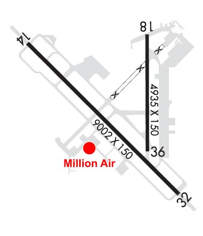 Airport Diagram might not be current. | |
| Facility Name: | GULFPORT-BILOXI INTL |
| City Name: | GULFPORT |
| County: | HARRISON |
| State abbrev: | MS |
| State Name: | MISSISSIPPI |
| Ownership: | PUBLICLY OWNED |
| Use: | OPEN TO THE PUBLIC |
| Owner's Name: | GULFPORT-BILOXI RGNL APT AUTH |
| Address: | 14035-L AIRPORT RD |
| GULFPORT, MS 39503 | |
| Owner's Phone: | 228-863-5951 |
| Manager's Name: | CLAY WILLIAMS |
| Address: | 14035-L AIRPORT RD |
| GULFPORT, MS 39503 | |
| Phone: | 228-863-5951 |
| FAA Region: | SOUTHERN |
| FAA Field Office: | JAN |
| Date | Sunrise | Sunset |
|---|---|---|
| 09/24/21 Friday | 6:46 | 18:51 |
| 09/25/21 Saturday | 6:46 | 18:49 |
| 09/26/21 Sunday | 6:47 | 18:48 |
| 09/27/21 Monday | 6:47 | 18:47 |
| 09/28/21 Tuesday | 6:48 | 18:46 |
| 09/29/21 Wednesday | 6:48 | 18:44 |
| 09/30/21 Thursday | 6:49 | 18:43 |
| 10/01/21 Friday | 6:50 | 18:42 |
| 10/02/21 Saturday | 6:50 | 18:41 |
| 10/03/21 Sunday | 6:51 | 18:39 |
| 10/04/21 Monday | 6:51 | 18:38 |
| 10/05/21 Tuesday | 6:52 | 18:37 |
| 10/06/21 Wednesday | 6:53 | 18:36 |
| 10/07/21 Thursday | 6:53 | 18:35 |
| Airport Attendance Schedule | CONTINUOUS |
| Airport Status | OPERATIONAL (This Status can change at any time - please check NOTAMS) |
| Airport Lighting Schedule | WHEN ATCT CLSD ACTVT MALSR RWY 14 & 32; HIRL RWY 14/32; MIRL RWY 18/36 - CTAF. MIRL RWY 18/36 NOT AVBL WHEN ATCT CLSD & RWY 14/32 ACTV. |
| Airport Storage Available | Tie Downs, Hanger |
| Extra Services Available | Air Freight, Air Ambulance, Avionics, Cargo Handling, Charter, Flight Instruction, Aircraft Rental, Aircraft Sales, Annual Surveying |
| Wind Indicator | YES - (lighted) |
| Control Tower | YES |
| CTAF Frequency | 123.700 |
| Unicom Frequency | 122.950 |
| Rotating Beacon Color | CLEAR-GREEN (Light Land Airport) |
| Segmented Circle | YES |
| Landing Fee | NO |
| Airport Inspected | FEDERAL - performed by FAA AIRPORTS FIELD PERSONNEL |
| Inspection Date | 02/23/2021 |
| Type of Fuel Available | Grade 100LL, JET A (freeze point -40C) |
| Airframe Repair Service | MAJOR |
| Power Plant Repair Service | MAJOR |
| Latitude | N3024.4 |
| Longitude | W08904.2 (ESTIMATED) |
| Arpt Elevation | 28ft (SURVEYED) |
| Magnetic Variation | 02W |
| 3 miles NE | of GULFPORT |
| Traffic Pattern Altitude | 800; TPA: 800 FT AGL LGT SNGL-ENG, 1200 FT AGL CONVENTIONAL, 1500 FT AGL JETS. |
| Sectional Chart | NEW ORLEANS |
| Operations (Reported) | Yearly | Avg. Daily |
|---|---|---|
| General Aviation Transient | 7462 | 20 |
| General Aviation Local | 5428 | 15 |
| Air Taxi | 3508 | 10 |
| Commerical | 5786 | 16 |
| Commuter | 0 | 0 |
| Military | 25605 | 70 |
| Aircraft based on Field | |
|---|---|
| General Aviation Singles | 33 |
| General Aviation Multi | 3 |
| Jet Aircraft | 2 |
| General Aviation Helicopters | 3 |
| Military Aircraft | 0 |
| Gliders | 0 |
| Ultralights | 0 |
| FSS on field | NO |
| FSS tie-in | GREENWOOD |
| FSS Phone | 1-800-WX-BRIEF |
| Who issues Notams | GPT |
| Notam D service at airport | YES |
| ARTCC Name | HOUSTON |
| Airport Certification | AIRPORT RECEIVING SCHEDULED AIR CARRIER SERVICE FROM CARRIERS CERTIFICATED BY THE CIVIL AERONAUTICS BOARD |
| Aircraft Rescue & Firefighting Index | AIRPORT HAS A CERTIFICATE UNDER CFR PART 139 |
| Airport of Entry | No |
| Custom Landing Rights | YES |
| Joint Civil/Military | No |
| Military Landing rights | YES |
| NATIONAL PLAN OF INTEGRATED AIRPORT SYSTEMS (NPIAS) |
| GRANT AGREEMENTS UNDER FAAP/ADAP/AIP |
| SURPLUS PROPERTY AGREEMENT UNDER PUBLIC LAW 289 |
| ASSURANCES PURSUANT TO TITLE VI, CIVIL RIGHTS ACT OF 1964 |
| AGREEMENT UNDER DLAND OR DCLA HAS EXPIRED. |
| NMRS LOW FLYING FISH SPOTTER ACFT OPERG THE SHORELINE BTN PASCAGOULA & GULFPORT SR-SS. |
| ACFT OPERG AS SKED OR CHARTER PSGR SVC SHALL NOT TAXI ON TWY 'A' NORTH OF TWY 'B' INTXN WO ESCORT FROM GND HANDLING AGENT OR ARPT AUTH. |
| CIVIL ACFT WITH WING SPAN OF 132 FT OR GREATER AND ALL ACR ACFT MUST BE ESCORTED ALONG TWY 'A' NORTH OF TWY 'C' BY GND HANDLING AGENT. |
| MILITARY ACFT OR ACFT SUPPORTING A MIL MISSION WITH WING SPAN OF 132 FT OR GREATER MUST HAVE ESCORT OR COORD TAXI PROCS WITH GND HANDLING AGENT PRIOR TO TXG ON TWY 'A'. |
| MAVERICK PAD APRON AREA ON N END OF TWY C RSTRD TO MIL ARCFT USE ONLY. |
| ARRESTING GEAR AVBL DURING ANG OPNS WITH 30 MIN PRIOR NOTICE. |
| CSTMS/AG/IMG: REQR OF PPR RESPONSIBLE FOR NTFYG CSTMS 48 HRS PRIOR NOTICE. |
| RSTD: C-5 ACFT PRK RSTD TO 1 ACFT AT A TIME DUE TO TXY WIDTH UNLESS COORD. |
| MILITARY: ANG: NO COMSEC STOR. CRTC AFLD MGMT OPS OPR 1300-2130Z++ MON; 1300-2230Z++ TUES-FRI & UNIT TRNG ASSEMBLY (UTA) WKNDS, NORMALLY FIRST WKND OF MONTH; CLSD HOL. 48 HR PN PPR RQR CTC CRTC AM OPS. CTC GUARD OPS 15 MIN PRIOR TO ARR 377.800. DSN 363-6027; C228-214-6027; FAX DSN 363-6031; C228-214-6031. |
| MILITARY: CAUTION: BASH PHASE II IN EFCT APR-MAY AND AUG-OCT. CTC AFLD MGMT FOR CURRENT BIRD WATCH COND. |
| PWR CHK PAD BTN RWY 18/36 AND TWY A RSTD TO MIL ACFT ONLY. |
| TAXILANE F20 BTN FBO AND TAXILANE G CLSD TO ACFT WITH WINGSPAN GREATER THAN 49 FT. POLE ADJ TAXILANE F20 NOT LGTD. |
| FUEL A+ (MIL) A (MILLION AIR GULFPORT, (C228-701-0400). |
| MILITARY: RSTD: PRK RSTD WI 100 FT LOX FAC LCTD NE CORNER APRON 1. |
| MILITARY: ANG: LTD SVC AVBL SPACE A PERS, NO PAX TERMINAL. |
| MILITARY: ARNG: MSTASMG OPS OPR 1300-2130Z++ MON; 1300-2230Z++ TUE-FRI & UNIT TRNG ASSEMBLY (UTA) WKND. PPR RQR CTC ARNG OPS, DSN 293-1378/1312, C228-214-1378/1312. ACFT INBD TO ARNG RAMP CTC BLACKJACK OPS (241.0/41.6) 10 MIN PRIOR TO LDG FOR PRK INSTR. |
| RWY 18/36 NOT AVBL FOR SKEDD ACR OPS WITH MORE THAN 9 PAX SEATS OR UNSKED ACR OPS AT LEAST 31 PAX SEATS. |
| ACFT OVER 115,000 LBS ARE RSTRD FROM 180 DEG TURNS ON RWY 18/36. ACFT WITH WINGSPAN GREATER THAN 223 FT ARE RSTRD FM OPRG ON TWY 'C' BTN TWY 'A' AND AER 32. |
| ACFT OVER 155000 LBS ARE RSTRD FM USING THE N PART OF TWY 'A' AT RY 18/36. ACFT OVER 316000 LBS ARE RSTRD FM USING THE S PART OF TWY 'A' BTN TWY 'C' & RY 14/32. |
| DUE TO APRON ACTVTY ACFT WITH WINGSPAN GREATER THAN 170 FT SHOULD BE ALERT ON TWY 'A' BTN TWY 'C' & TWY 'B'. |
| 150 FT AGL CRANE 4600 FT N OF RWY 18 THLD. |
| RWY 14/3 2 2S-175. |
Airport Communications & Frequencies:
| |||||||||||||||||||||||||||||||||||||||
| Runway: 14 | Runway: 32 | ||
| Mag heading: | 137° | Mag heading: | 317° |
| Rwy Slope: | .03% Up | Rwy Slope: | -.03% Down |
| Approach: | ILS | Approach: | ILS |
| Pattern: | Left Traffic | Pattern: | Left Traffic |
| Markings: | PRECISION INSTRUMENT | Markings: | PRECISION INSTRUMENT |
| Marking Condition: | GOOD | Marking Condition: | GOOD |
| Arresting Dev: | BAK-14; BAK-14 BAK-12B(B) (1800'). | Arresting Dev: | BAK-14; BAK-14 BAK-12B(B) (1300'). |
| Lat & Long: | N3024.9 W08904.9 | Lat. & Long.: | N3023.8 W08903.7 |
| Elev: | 18.9 ft. MSL | Elev: | 22.0 ft. MSL |
| TCH: | 73 ft. AGL | TCH: | 72 ft. AGL |
| Visual Glide Path: | 3.00 degrees | Visual Glide Path: | 3.00 degrees |
| Displaced Threshold: | No | Displaced Threshold: | No |
| Touchdown Zone: | YES | Touchdown Zone: | YES |
| Touchdown Elev.: | 26.5 feet | Touchdown Elev.: | 27.2 feet |
| Visual Glide Slope: | 4-Light PAPI on RIGHT side of Runway | Visual Glide Slope: | 4-Light PAPI on LEFT side of Runway |
| RVR Equipment: | TOUCHDOWN | RVR Equipment: | TOUCHDOWN |
| RVV Equipment: | NO | RVV Equipment: | NO |
| Approach Lights: | MALSR - 1,400 foot medium intensity approach lighting system with runway alignment indicator lights | Approach Lights: | MALSR - 1,400 foot medium intensity approach lighting system with runway alignment indicator lights |
| REIL: | NO | REIL: | NO |
| Centerline Lights: | NO | Centerline Lights: | NO |
| Touchdown lights: | NO | Touchdown lights: | NO |
| Runway Category: | Precision Instrument Runway | Runway Category: | Precision Instrument Runway |
| Declared Distances: | Declared Distances: | ||
| Obstructions: | TREES | Obstructions: | TOWER |
| Marked: | NOT Marked/Lighted | Marked: | LIGHTED |
| Clearance slope: | 34:1 | Clearance slope: | 27:1 |
| Obstruction height: | 50 feet AGL | Obstruction height: | 70 feet AGL |
| Dist. from runway: | 1900 feet | Dist. from runway: | 2100 feet |
| Centerline offset: | 300 right of centerline | Centerline offset: | |
| Comments: | Comments: |
| Runway: 18 | Runway: 36 | ||
| Mag heading: | 182° | Mag heading: | 2° |
| Rwy Slope: | .04% Up | Rwy Slope: | -.04% Down |
| Approach: | Approach: | ||
| Pattern: | Left Traffic | Pattern: | Left Traffic |
| Markings: | NONPRECISION INSTRUMENT | Markings: | NONPRECISION INSTRUMENT |
| Marking Condition: | GOOD | Marking Condition: | GOOD |
| Arresting Dev: | Arresting Dev: | ||
| Lat & Long: | N3025.0 W08904.0 | Lat. & Long.: | N3024.1 W08904.0 |
| Elev: | 23.5 ft. MSL | Elev: | 25.5 ft. MSL |
| TCH: | 50 ft. AGL | TCH: | 50 ft. AGL |
| Visual Glide Path: | 3.00 degrees | Visual Glide Path: | 3.00 degrees |
| Displaced Threshold: | No | Displaced Threshold: | No |
| Touchdown Zone: | YES | Touchdown Zone: | YES |
| Touchdown Elev.: | 26.7 feet | Touchdown Elev.: | 27.0 feet |
| Visual Glide Slope: | 4-Light PAPI on RIGHT side of Runway | Visual Glide Slope: | 4-Light PAPI on LEFT side of Runway |
| RVR Equipment: | RVR Equipment: | ||
| RVV Equipment: | NO | RVV Equipment: | NO |
| Approach Lights: | Approach Lights: | ||
| REIL: | NO | REIL: | NO |
| Centerline Lights: | NO | Centerline Lights: | NO |
| Touchdown lights: | NO | Touchdown lights: | NO |
| Runway Category: | Runway with a Non-precision Approach having visibility minimums greater than 3/4 mile | Runway Category: | Runway with a Non-precision Approach having visibility minimums greater than 3/4 mile |
| Declared Distances: | Declared Distances: | ||
| Obstructions: | TREE | Obstructions: | TREES |
| Marked: | NOT Marked/Lighted | Marked: | NOT Marked/Lighted |
| Clearance slope: | 25:1 | Clearance slope: | 40:1 |
| Obstruction height: | 42 feet AGL | Obstruction height: | 40 feet AGL |
| Dist. from runway: | 1300 feet | Dist. from runway: | 1800 feet |
| Centerline offset: | 200 right of centerline | Centerline offset: | |
| Comments: | Comments: |
Thanks for using FltPlan.com
all rights reserved © 1999-2021 by Flight Plan LLC