| GLACIER PARK INTL KALISPELL MT |
| |
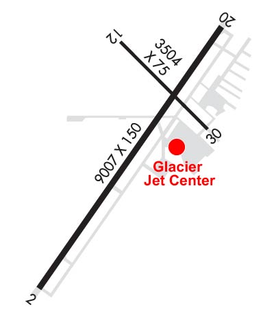
| Lat: N 4818.6 Long: W 11415.4 Elev: 2977 Var: -15 Longest Runway: 9007 | ||
| Dept. ATIS: 132.62 Arr. ATIS: 132.62 AWOS: 135.27 Ground: 121.6 Tower: 124.55 | ||
| ||||||||||||||||||||||||||||||||||||||||||||||||||||||||||||||||||||
| ||||||||||||||||||||||||||||||||||||||||||||||||||||||||||||||||||||
| ||||||||||||||||||||||||||||||||||||||||||||||||||||||||||||||||||||
| Rwy | Rwy | |||||||
| 9007x150 | 9007' | 111.50 - 019° | 9007x150 | 9007' | ||||
| 3510x75 | 3510' | 3510x75 | 3510' | |||||
| Runway ID | Single Wheel | Double Wheel | Double Tandem Wheel | Dual Double Wheel |
| 02/20 | 115,000 | 198,000 | 321,000 | N/A |
| 12/30 | 25,000 | 40,000 | N/A | N/A |
| These numbers are Advisory and are not limits. The Airport Manager should have more accurate Weight Limits | ||||
 Airport Diagram might not be current. | |
| Facility Name: | GLACIER PARK INTL |
| City Name: | KALISPELL |
| County: | FLATHEAD |
| State abbrev: | MT |
| State Name: | MONTANA |
| Ownership: | PUBLICLY OWNED |
| Use: | OPEN TO THE PUBLIC |
| Owner's Name: | FLATHEAD MUNI ARPT AUTHORITY |
| Address: | 4170 HWY 2 |
| KALISPELL, MT 59901 | |
| Owner's Phone: | 406-257-5994 |
| Manager's Name: | ROB RATKOWSKI |
| Address: | 4170 HWY 2 |
| KALISPELL, MT 59901 | |
| Phone: | 406-257-5994 |
| FAA Region: | NORTHWEST MOUNTAIN |
| FAA Field Office: | HLN |
| Date | Sunrise | Sunset |
|---|---|---|
| 09/24/21 Friday | 7:26 | 19:31 |
| 09/25/21 Saturday | 7:28 | 19:29 |
| 09/26/21 Sunday | 7:29 | 19:27 |
| 09/27/21 Monday | 7:30 | 19:25 |
| 09/28/21 Tuesday | 7:32 | 19:23 |
| 09/29/21 Wednesday | 7:33 | 19:21 |
| 09/30/21 Thursday | 7:35 | 19:18 |
| 10/01/21 Friday | 7:36 | 19:16 |
| 10/02/21 Saturday | 7:38 | 19:14 |
| 10/03/21 Sunday | 7:39 | 19:12 |
| 10/04/21 Monday | 7:40 | 19:10 |
| 10/05/21 Tuesday | 7:42 | 19:08 |
| 10/06/21 Wednesday | 7:43 | 19:06 |
| 10/07/21 Thursday | 7:45 | 19:04 |
| Airport Attendance Schedule | CONTINUOUS |
| Airport Status | OPERATIONAL (This Status can change at any time - please check NOTAMS) |
| Airport Lighting Schedule | ACTVT HIRL RY 02/20, MIRL RY 12/30, MALSR RY 02, & REIL RY 20 - CTAF. RY 02, RY 20 AND RY 30 PAPIS OPR CONTINUOUSLY. |
| Airport Storage Available | Tie Downs, Hanger |
| Extra Services Available | Avionics, Charter, Flight Instruction, Aircraft Rental, Annual Surveying |
| Wind Indicator | YES - (lighted) |
| Control Tower | YES |
| CTAF Frequency | 124.550 |
| Unicom Frequency | 122.950 |
| Rotating Beacon Color | CLEAR-GREEN (Light Land Airport) |
| Segmented Circle | YES |
| Landing Fee | NO |
| Airport Inspected | FEDERAL - performed by FAA AIRPORTS FIELD PERSONNEL |
| Inspection Date | 07/26/2019 |
| Type of Fuel Available | Grade 100LL, JET A (freeze point -40C) |
| Airframe Repair Service | MAJOR |
| Power Plant Repair Service | MAJOR |
| Latitude | N4818.6 |
| Longitude | W11415.4 (ESTIMATED) |
| Arpt Elevation | 2976ft (SURVEYED) |
| Magnetic Variation | 15E |
| 6 miles NE | of KALISPELL |
| Traffic Pattern Altitude | |
| Sectional Chart | GREAT FALLS |
| Operations (Reported) | Yearly | Avg. Daily |
|---|---|---|
| General Aviation Transient | 12359 | 34 |
| General Aviation Local | 4429 | 12 |
| Air Taxi | 5603 | 15 |
| Commerical | 7083 | 19 |
| Commuter | 0 | 0 |
| Military | 1867 | 5 |
| Aircraft based on Field | |
|---|---|
| General Aviation Singles | 124 |
| General Aviation Multi | 26 |
| Jet Aircraft | 5 |
| General Aviation Helicopters | 4 |
| Military Aircraft | 0 |
| Gliders | 0 |
| Ultralights | 0 |
| FSS on field | NO |
| FSS tie-in | GREAT FALLS |
| FSS Phone | 1-800-WX-BRIEF |
| Who issues Notams | GPI |
| Notam D service at airport | YES |
| ARTCC Name | SALT LAKE CITY |
| Airport Certification | AIRPORT RECEIVING SCHEDULED AIR CARRIER SERVICE FROM CARRIERS CERTIFICATED BY THE CIVIL AERONAUTICS BOARD; CLSD TO UNSKED ACR OPNS WITH MORE THAN 30 PSGR SEATS EXCP PPR CALL AMGR 406-257-5994. |
| Aircraft Rescue & Firefighting Index | AIRPORT HAS A CERTIFICATE UNDER CFR PART 139 |
| Airport of Entry | No |
| Custom Landing Rights | YES |
| Joint Civil/Military | No |
| Military Landing rights | YES |
| NATIONAL PLAN OF INTEGRATED AIRPORT SYSTEMS (NPIAS) |
| GRANT AGREEMENTS UNDER FAAP/ADAP/AIP |
| ASSURANCES PURSUANT TO TITLE VI, CIVIL RIGHTS ACT OF 1964 |
| AGREEMENT UNDER DLAND OR DCLA HAS EXPIRED. |
| COLD TEMPERATURE AIRPORT. ALTITUDE CORRECTION REQUIRED AT OR BELOW -15C. |
Airport Communications & Frequencies:
| |||||||||||||||
| Runway: 02 | Runway: 20 | ||
| Mag heading: | 20° | Mag heading: | 200° |
| Rwy Slope: | .16% Up | Rwy Slope: | -.16% Down |
| Approach: | ILS | Approach: | |
| Pattern: | Left Traffic | Pattern: | Left Traffic |
| Markings: | PRECISION INSTRUMENT | Markings: | PRECISION INSTRUMENT |
| Marking Condition: | GOOD | Marking Condition: | GOOD |
| Arresting Dev: | Arresting Dev: | ||
| Lat & Long: | N4817.9 W11416.1 | Lat. & Long.: | N4819.1 W11414.8 |
| Elev: | 2962.3 ft. MSL | Elev: | 2976.7 ft. MSL |
| TCH: | 50 ft. AGL | TCH: | 45 ft. AGL |
| Visual Glide Path: | 3.00 degrees | Visual Glide Path: | 3.00 degrees |
| Displaced Threshold: | No | Displaced Threshold: | No |
| Touchdown Zone: | YES | Touchdown Zone: | YES |
| Touchdown Elev.: | 2965.9 feet | Touchdown Elev.: | 2976.8 feet |
| Visual Glide Slope: | 4-Light PAPI on LEFT side of Runway | Visual Glide Slope: | 4-Light PAPI on LEFT side of Runway |
| RVR Equipment: | RVR Equipment: | ||
| RVV Equipment: | NO | RVV Equipment: | NO |
| Approach Lights: | MALSR - 1,400 foot medium intensity approach lighting system with runway alignment indicator lights | Approach Lights: | |
| REIL: | NO | REIL: | YES |
| Centerline Lights: | NO | Centerline Lights: | NO |
| Touchdown lights: | NO | Touchdown lights: | NO |
| Runway Category: | Precision Instrument Runway | Runway Category: | D |
| Declared Distances: | TORA:9007' TODA:9007' ASDA:9007' LDA:9007' | Declared Distances: | TORA:9007' TODA:9007' ASDA:9007' LDA:9007' |
| Runway: 12 | Runway: 30 | ||
| Mag heading: | 121° | Mag heading: | 301° |
| Rwy Slope: | -.04% Down | Rwy Slope: | .04% Up |
| Approach: | Approach: | ||
| Pattern: | Left Traffic | Pattern: | Left Traffic |
| Markings: | NONPRECISION INSTRUMENT | Markings: | NONPRECISION INSTRUMENT |
| Marking Condition: | GOOD | Marking Condition: | GOOD |
| Arresting Dev: | Arresting Dev: | ||
| Lat & Long: | N4819.1 W11415.5 | Lat. & Long.: | N4818.7 W11414.9 |
| Elev: | 2972.9 ft. MSL | Elev: | 2971.4 ft. MSL |
| TCH: | TCH: | 26 ft. AGL | |
| Visual Glide Path: | Visual Glide Path: | 3.50 degrees | |
| Displaced Threshold: | No | Displaced Threshold: | No |
| Touchdown Zone: | YES | Touchdown Zone: | YES |
| Touchdown Elev.: | 2973.7 feet | Touchdown Elev.: | 2973.6 feet |
| Visual Glide Slope: | Visual Glide Slope: | 2-Light PAPI on LEFT side of Runway | |
| RVR Equipment: | RVR Equipment: | ||
| RVV Equipment: | NO | RVV Equipment: | NO |
| Approach Lights: | Approach Lights: | ||
| REIL: | NO | REIL: | NO |
| Centerline Lights: | NO | Centerline Lights: | NO |
| Touchdown lights: | NO | Touchdown lights: | NO |
| Runway Category: | Runway with a Visual Approach | Runway Category: | Runway with a Non-precision Approach |
| Declared Distances: | TORA:3510' TODA:3510' ASDA:3510' LDA:3510' | Declared Distances: | TORA:3510' TODA:3510' ASDA:3510' LDA:3510' |
Thanks for using FltPlan.com
all rights reserved © 1999-2021 by Flight Plan LLC