
| GRAYLING AAF GRAYLING MI |
| |
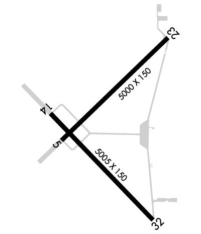
| Lat: N 4440.8 Long: W 08443.7 Elev: 1158 Var: +06 Longest Runway: 5005 | ||
| Dept. ATIS: 119.07 Arr. ATIS: 119.07 AWOS: 119.07 Ground: 121.9 Tower: 124.65 | ||
| ||||||
| ||||||
|
| Rwy | Rwy | |||||||
| 5000x150 | 5000' | 5000x150 | 5000' | |||||
| 5005x150 | 5005' | 5005x150 | 4712' | |||||
| Runway ID | Single Wheel | Double Wheel | Double Tandem Wheel | Dual Double Wheel |
| 05/23 | N/A | N/A | N/A | N/A |
| 14/32 | N/A | N/A | N/A | N/A |
| These numbers are Advisory and are not limits. The Airport Manager should have more accurate Weight Limits | ||||
 Airport Diagram might not be current. | |
| Facility Name: | GRAYLING AAF |
| City Name: | GRAYLING |
| County: | CRAWFORD |
| State abbrev: | MI |
| State Name: | MICHIGAN |
| Ownership: | ARMY OWNED |
| Use: | OPEN TO THE PUBLIC |
| Owner's Name: | US ARMY |
| Address: | MI DEPT OF MILITARY & VETERANS AFF, 3411 N MLK BLVD |
| LANSING, MI 48906-2934 | |
| Owner's Phone: | 517-483-5645 |
| Manager's Name: | SCOTT KARNER |
| Address: | JMTC GAAF BLDG 1160, CAMP GRAYLING |
| GRAYLING, MI 49738 | |
| Phone: | 989-344-4301; C989-344-4301 (FLT OPS) OR C517-897-8266 (FLT OPS SUPVR CELL); C989-344-4310 (AMGR CELL). |
| FAA Region: | GREAT LAKES |
| FAA Field Office: | DET |
| Date | Sunrise | Sunset |
|---|---|---|
| 07/28/26 Tuesday | 6:20 | 21:10 |
| 07/29/26 Wednesday | 6:22 | 21:09 |
| 07/30/26 Thursday | 6:23 | 21:07 |
| 07/31/26 Friday | 6:24 | 21:06 |
| 08/01/26 Saturday | 6:25 | 21:05 |
| 08/02/26 Sunday | 6:26 | 21:04 |
| 08/03/26 Monday | 6:27 | 21:02 |
| 08/04/26 Tuesday | 6:28 | 21:01 |
| 08/05/26 Wednesday | 6:29 | 21:00 |
| 08/06/26 Thursday | 6:31 | 20:58 |
| 08/07/26 Friday | 6:32 | 20:57 |
| 08/08/26 Saturday | 6:33 | 20:56 |
| 08/09/26 Sunday | 6:34 | 20:54 |
| 08/10/26 Monday | 6:35 | 20:53 |
| Airport Attendance Schedule | TUE-FRI 1200-2200Z; EXC FEDERAL HOLS OR BY NOTAM. |
| Airport Status | OPERATIONAL (This Status can change at any time - please check NOTAMS) |
| Airport Lighting Schedule | ACTVT REIL RWY 14, 32, 05, & 23; PAPI RWY 14, 32, 05, & 23; MIRL RWY 14/32 & 05/23 - CTAF. |
| Airport Storage Available | Tie Downs |
| Extra Services Available | NONE |
| Wind Indicator | YES - (lighted) |
| Control Tower | YES |
| CTAF Frequency | 124.650 |
| Unicom Frequency | |
| Rotating Beacon Color | SWG |
| Segmented Circle | YES |
| Landing Fee | NO |
| Airport Inspected | STATE - performed by STATE AERONAUTICAL PERSONNEL |
| Inspection Date | 05/18/2023 |
| Type of Fuel Available | Grade 100LL, JET A; -10100LL & JET A+ AVBL H24 SELF SVC VIA CREDIT CARD. FOR FUEL SUPPORT CTC BASOPS AT 989-344-4301, 24 HR PN FOR FUEL SUPPORT OUTSIDE OPRG HRS. |
| Airframe Repair Service | None |
| Power Plant Repair Service | None |
| Latitude | N4440.8 |
| Longitude | W08443.7 (ESTIMATED) |
| Arpt Elevation | 1158ft (SURVEYED) |
| Magnetic Variation | 06W |
| 1 miles NW | of GRAYLING |
| Traffic Pattern Altitude | ROTOR WING 1700 FT MSL; FIXED WING 2200 FT MSL; OVHD 2700 FT MSL. |
| Sectional Chart | LAKE HURON |
| Operations (Reported) | Yearly | Avg. Daily |
|---|---|---|
| General Aviation Transient | 0 | 0 |
| General Aviation Local | 0 | 0 |
| Air Taxi | 0 | 0 |
| Commerical | 0 | 0 |
| Commuter | 0 | 0 |
| Military | 0 | 0 |
| Aircraft based on Field | |
|---|---|
| General Aviation Singles | 0 |
| General Aviation Multi | 0 |
| Jet Aircraft | 0 |
| General Aviation Helicopters | 0 |
| Military Aircraft | 0 |
| Gliders | 0 |
| Ultralights | 0 |
| FSS on field | NO |
| FSS tie-in | LANSING |
| FSS Phone | 1-800-WX-BRIEF |
| Who issues Notams | GOV |
| Notam D service at airport | YES |
| ARTCC Name | MINNEAPOLIS |
| Airport Certification | ARFF CAPABILITIES LTD OCT-MAY. |
| Aircraft Rescue & Firefighting Index | None |
| Airport of Entry | No |
| Custom Landing Rights | No |
| Joint Civil/Military | YES |
| Military Landing rights | No |
| NATIONAL PLAN OF INTEGRATED AIRPORT SYSTEMS (NPIAS) |
| MILITARY: ALL HAZUS CARGO MUST BE APVD BY AIRFIELD MGR. |
| ALL AFLD SIGNS UNLGTD. ALL TWYS UNLGTD. |
| EXP CLOSURE OR RDCD SVC PER NOTAM. |
| PAVEMENT EVAL NOT CURRENT. ALL AMC ACFT CTC MGMT FOR WAIVERS & RSTRNS. |
| NO RWY SHOULDERS. NO RWY OVRNS. NO TWY SHOULDERS. ALL TWY SFC MRKGS NSTD & FADED. ALL MIL RAMP SFCS NSTD & FADED. GA RAMP SFC MRKGS NSTD & FADED. GA FUEL FARM RAMP SFC MRKGS NSTD & FADED. |
| BIRD & WILDLIFE HAZ. NATIVE RAVENS & CROWS IN & ARND AFLD YEAR-ROUND. |
| EXTSV MIL HEL TFC JUN THRU AUG. |
| PARTS OF THE AIRFIELD CLSD DRG WINTER MONTHS - CK NOTAMS. |
| CIV TRML BLDG ACES: 5-4-3-2-1. |
| FOR FICON C989-344-4301, UNMON OUTSIDE OPRG HRS. |
| MILITARY: SVC: UNAVBL EXC 24 HR PPR 989-344-4301, ACFT MUST MEET PPR TIME WI 30 MINS. |
| RWY 05 OPEN TO VFR LDGS SR-SS. |
| RWY 05/2 3 IREG SFC; FOD LCTD THRUT RWY. |
| RWY 05/2 3 PCN 18 DRG FROST CONDS. |
| RWY 14/3 2 PCN 59 DRG FROST CONDS. |
Airport Communications & Frequencies:
| |||||||||||||||||
| Runway: 05 | Runway: 23 | ||
| Mag heading: | 52° | Mag heading: | 232° |
| Rwy Slope: | .13% Up | Rwy Slope: | -.13% Down |
| Approach: | Approach: | ||
| Pattern: | Left Traffic | Pattern: | Right Traffic |
| Markings: | NONPRECISION INSTRUMENT | Markings: | NONPRECISION INSTRUMENT |
| Marking Condition: | FAIR | Marking Condition: | FAIR |
| Arresting Dev: | Arresting Dev: | ||
| Lat & Long: | N4440.8 W08444.1 | Lat. & Long.: | N4441.3 W08443.3 |
| Elev: | 1151.4 ft. MSL | Elev: | 1158.0 ft. MSL |
| TCH: | 41 ft. AGL | TCH: | 30 ft. AGL |
| Visual Glide Path: | 4.00 degrees | Visual Glide Path: | 3.00 degrees |
| Displaced Threshold: | No | Displaced Threshold: | No |
| Touchdown Zone: | YES | Touchdown Zone: | YES |
| Touchdown Elev.: | 1156.4 feet | Touchdown Elev.: | 1158.1 feet |
| Visual Glide Slope: | 4-Light PAPI on LEFT side of Runway | Visual Glide Slope: | 4-Light PAPI on LEFT side of Runway |
| RVR Equipment: | RVR Equipment: | ||
| RVV Equipment: | NO | RVV Equipment: | NO |
| Approach Lights: | Approach Lights: | ||
| REIL: | YES | REIL: | YES |
| Centerline Lights: | NO | Centerline Lights: | NO |
| Touchdown lights: | NO | Touchdown lights: | NO |
| Runway Category: | Runway with a Visual Approach | Runway Category: | Runway with a Visual Approach |
| Declared Distances: | Declared Distances: | ||
| Obstructions: | TREES | Obstructions: | TREES |
| Marked: | NOT Marked/Lighted | Marked: | NOT Marked/Lighted |
| Clearance slope: | 15:1 | Clearance slope: | 18:1 |
| Obstruction height: | 75 feet AGL | Obstruction height: | 58 feet AGL |
| Dist. from runway: | 1362 feet | Dist. from runway: | 1277 feet |
| Centerline offset: | 25 right of centerline | Centerline offset: | 125 feet left of centerline |
| Comments: | Comments: |
| Runway: 14 | Runway: 32 | ||
| Mag heading: | 142° | Mag heading: | 322° |
| Rwy Slope: | -.08% Down | Rwy Slope: | .08% Up |
| Approach: | Approach: | ||
| Pattern: | Right Traffic | Pattern: | Left Traffic |
| Markings: | NONPRECISION INSTRUMENT | Markings: | NONPRECISION INSTRUMENT |
| Marking Condition: | FAIR | Marking Condition: | FAIR |
| Arresting Dev: | Arresting Dev: | ||
| Lat & Long: | N4440.9 W08444.2 | Lat. & Long.: | N4440.3 W08443.4 |
| Elev: | 1152.9 ft. MSL | Elev: | 1149.1 ft. MSL |
| TCH: | 29 ft. AGL | TCH: | 33 ft. AGL |
| Visual Glide Path: | 3.00 degrees | Visual Glide Path: | 3.50 degrees |
| Displaced Threshold: | No | Displaced Threshold: | 293 feet |
| Touchdown Zone: | YES | Touchdown Zone: | YES |
| Touchdown Elev.: | 1153.8 feet | Touchdown Elev.: | 1153.8 feet |
| Visual Glide Slope: | 4-Light PAPI on LEFT side of Runway | Visual Glide Slope: | 4-Light PAPI on LEFT side of Runway |
| RVR Equipment: | RVR Equipment: | ||
| RVV Equipment: | NO | RVV Equipment: | NO |
| Approach Lights: | Approach Lights: | ||
| REIL: | YES | REIL: | YES |
| Centerline Lights: | NO | Centerline Lights: | NO |
| Touchdown lights: | NO | Touchdown lights: | NO |
| Runway Category: | Runway with a Non-precision Approach having visibility minimums greater than 3/4 mile | Runway Category: | Runway with a Visual Approach |
| Declared Distances: | Declared Distances: | ||
| Obstructions: | TREE | Obstructions: | TREES; +26 FT PLINE, 488 FT DIST, 11:1; +15 FT ROAD, 250 FT DIST, 250 FT L, 3:1. |
| Marked: | NOT Marked/Lighted | Marked: | NOT Marked/Lighted |
| Clearance slope: | 20:1 | Clearance slope: | 12:1; APCH RATIO 20:1 TO DTHR OVR 68 FT TREES, 1423 FT DIST, 125 FT R. |
| Obstruction height: | 60 feet AGL | Obstruction height: | 61 feet AGL |
| Dist. from runway: | 1438 feet | Dist. from runway: | 939 feet |
| Centerline offset: | 435 right of centerline | Centerline offset: | 200 feet right of centerline |
| Comments: | Comments: |
Thanks for using FltPlan.com
all rights reserved © 1999-2026 by Flight Plan LLC
