
| NEVADA COUNTY AIR PARK GRASS VALLEY CA |
| |
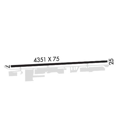
| Lat: N 3913.4 Long: W 12100.2 Elev: 3158 Var: -16 Longest Runway: 4657 | ||
| AWOS: 121.32 CTAF: 122.72 | ||
| ||||||||||||||||||||||||||||||||||||||||||||
| ||||||||||||||||||||||||||||||||||||||||||||
| ||||||||||||||||||||||||||||||||||||||||||||
| Rwy | Rwy | |||||||
| 4657x75 | 4657' | 4657x75 | 4353' | |||||
| Runway ID | Single Wheel | Double Wheel | Double Tandem Wheel | Dual Double Wheel |
| 07/25 | 30,000 | N/A | N/A | N/A |
| These numbers are Advisory and are not limits. The Airport Manager should have more accurate Weight Limits | ||||
 Airport Diagram might not be current. | |
| Facility Name: | NEVADA COUNTY |
| City Name: | GRASS VALLEY |
| County: | NEVADA |
| State abbrev: | CA |
| State Name: | CALIFORNIA |
| Ownership: | PUBLICLY OWNED |
| Use: | OPEN TO THE PUBLIC |
| Owner's Name: | NEVADA COUNTY |
| Address: | 950 MAIDU AVE |
| NEVADA CITY, CA 95959 | |
| Owner's Phone: | 530-273-3374 |
| Manager's Name: | KEVIN EDWARDS; KEVIN.EDWARDS2@CO.NEVADA.CA.US |
| Address: | 950 MAIDU AVENUE |
| NEVADA CITY, CA 95959-8617 | |
| Phone: | 530-273-3374 |
| FAA Region: | WESTERN-PACIFIC |
| FAA Field Office: | SFO |
| Date | Sunrise | Sunset |
|---|---|---|
| 09/24/21 Friday | 6:53 | 18:58 |
| 09/25/21 Saturday | 6:54 | 18:56 |
| 09/26/21 Sunday | 6:55 | 18:55 |
| 09/27/21 Monday | 6:56 | 18:53 |
| 09/28/21 Tuesday | 6:57 | 18:52 |
| 09/29/21 Wednesday | 6:58 | 18:50 |
| 09/30/21 Thursday | 6:59 | 18:48 |
| 10/01/21 Friday | 7:00 | 18:47 |
| 10/02/21 Saturday | 7:01 | 18:45 |
| 10/03/21 Sunday | 7:02 | 18:44 |
| 10/04/21 Monday | 7:03 | 18:42 |
| 10/05/21 Tuesday | 7:04 | 18:41 |
| 10/06/21 Wednesday | 7:05 | 18:39 |
| 10/07/21 Thursday | 7:06 | 18:37 |
| Airport Attendance Schedule | 7 Days A Week 0800-2000 |
| Airport Status | OPERATIONAL (This Status can change at any time - please check NOTAMS) |
| Airport Lighting Schedule | ACTVT VASI RWY 07 & 25; MIRL RWY 07/25 - CTAF. |
| Airport Storage Available | Tie Downs |
| Extra Services Available | Air Freight, Charter, Flight Instruction, Aircraft Rental |
| Wind Indicator | YES - (lighted) |
| Control Tower | NO |
| CTAF Frequency | 122.725 |
| Unicom Frequency | 122.725 |
| Rotating Beacon Color | CLEAR-GREEN (Light Land Airport) |
| Segmented Circle | YES |
| Landing Fee | NO |
| Airport Inspected | STATE - performed by STATE AERONAUTICAL PERSONNEL |
| Inspection Date | 08/29/2019 |
| Type of Fuel Available | Grade 100LL, JET A (freeze point -40C) |
| Airframe Repair Service | MAJOR |
| Power Plant Repair Service | MAJOR |
| Latitude | N3913.4 |
| Longitude | W12100.2 (ESTIMATED) |
| Arpt Elevation | 3157ft (SURVEYED) |
| Magnetic Variation | 16E |
| 3 miles E | of GRASS VALLEY |
| Traffic Pattern Altitude | |
| Sectional Chart | SAN FRANCISCO |
| Operations (Reported) | Yearly | Avg. Daily |
|---|---|---|
| General Aviation Transient | 12000 | 33 |
| General Aviation Local | 14750 | 40 |
| Air Taxi | 1000 | 3 |
| Commerical | 0 | 0 |
| Commuter | 0 | 0 |
| Military | 0 | 0 |
| Aircraft based on Field | |
|---|---|
| General Aviation Singles | 133 |
| General Aviation Multi | 7 |
| Jet Aircraft | 0 |
| General Aviation Helicopters | 0 |
| Military Aircraft | 0 |
| Gliders | 2 |
| Ultralights | 0 |
| FSS on field | NO |
| FSS tie-in | RANCHO MURIETA |
| FSS Phone | 1-800-WX-BRIEF |
| Who issues Notams | GOO |
| Notam D service at airport | YES |
| ARTCC Name | OAKLAND |
| Airport Certification | |
| Aircraft Rescue & Firefighting Index | None |
| Airport of Entry | No |
| Custom Landing Rights | No |
| Joint Civil/Military | No |
| Military Landing rights | YES |
| NATIONAL PLAN OF INTEGRATED AIRPORT SYSTEMS (NPIAS) |
| GRANT AGREEMENTS UNDER FAAP/ADAP/AIP |
| ASSURANCES PURSUANT TO TITLE VI, CIVIL RIGHTS ACT OF 1964 |
| RWY 07/25 SLOPES DOWNHILL TO WEST; RECOMMEND TKOF RWY 25. |
| FOR CD CTC NORCAL APCH AT 916-361-6874. |
Airport Communications & Frequencies:
| ||||||||||||||
| Runway: 07 | Runway: 25 | ||
| Mag heading: | 71° | Mag heading: | 251° |
| Rwy Slope: | 1.87% Up | Rwy Slope: | -1.87% Down |
| Approach: | Approach: | ||
| Pattern: | Left Traffic | Pattern: | Left Traffic |
| Markings: | NONPRECISION INSTRUMENT | Markings: | NONPRECISION INSTRUMENT |
| Marking Condition: | GOOD | Marking Condition: | GOOD |
| Arresting Dev: | Arresting Dev: | ||
| Lat & Long: | N3913.4 W12100.6 | Lat. & Long.: | N3913.5 W12059.7 |
| Elev: | 3070.7 ft. MSL | Elev: | 3157.6 ft. MSL |
| TCH: | 40 ft. AGL | TCH: | 37 ft. AGL |
| Visual Glide Path: | 3.00 degrees | Visual Glide Path: | 3.50 degrees |
| Displaced Threshold: | No | Displaced Threshold: | 304 feet |
| Touchdown Zone: | YES | Touchdown Zone: | YES |
| Touchdown Elev.: | 3130.7 feet | Touchdown Elev.: | 3154.2 feet |
| Visual Glide Slope: | 4-BOX VASI ON LEFT SIDE OF RUNWAY | Visual Glide Slope: | 2-Box VASI on LEFT side of Runway; OTS INDEFLY. |
| RVR Equipment: | RVR Equipment: | ||
| RVV Equipment: | NO | RVV Equipment: | NO |
| Approach Lights: | Approach Lights: | ||
| REIL: | YES; OTS INDEFLY. | REIL: | YES; OTS INDEFLY. |
| Centerline Lights: | NO | Centerline Lights: | NO |
| Touchdown lights: | NO | Touchdown lights: | NO |
| Runway Category: | Runway with a Non-precision Approach having visibility minimums greater than 3/4 mile | Runway Category: | Runway with a Visual Approach |
| Declared Distances: | Declared Distances: | ||
| Obstructions: | TREES | Obstructions: | POLE |
| Marked: | NOT Marked/Lighted | Marked: | MARKED and LIGHTED |
| Clearance slope: | 20:1 | Clearance slope: | 24:1 |
| Obstruction height: | 20 feet AGL | Obstruction height: | 100 feet AGL |
| Dist. from runway: | 612 feet | Dist. from runway: | 2600 feet |
| Centerline offset: | 190 left of centerline | Centerline offset: | 235 feet right of centerline |
| Comments: | Comments: |
Thanks for using FltPlan.com
all rights reserved © 1999-2021 by Flight Plan LLC