
| GROTON-NEW LONDON GROTON (NEW LONDON) CT |
| |
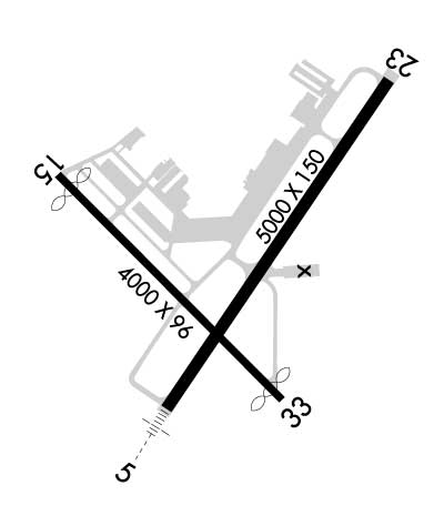
| Lat: N 4119.8 Long: W 07202.7 Elev: 9 Var: +14 Longest Runway: 5000 | ||
| Clr Del: 119.85 tw cld Dept. ATIS: 127.0 Arr. ATIS: 127.0 AWOS: 127.0 Ground: 121.65 Tower: 125.6 | ||
| |||||||||||||||||||||||||||||||||||||||||||||||||||||||||||||||||||||
| |||||||||||||||||||||||||||||||||||||||||||||||||||||||||||||||||||||
| |||||||||||||||||||||||||||||||||||||||||||||||||||||||||||||||||||||
| Rwy | Rwy | |||||||
| 5000x150 | 5000' | 111.30 - 048° | 5000x150 | 5000' | ||||
| 4000x96 | 3693' | 4000x96 | 3795' | |||||
| Runway ID | Single Wheel | Double Wheel | Double Tandem Wheel | Dual Double Wheel |
| 05/23 | 90,000 | 113,000 | 200,000 | N/A |
| 15/33 | 90,000 | 113,000 | N/A | N/A |
| These numbers are Advisory and are not limits. The Airport Manager should have more accurate Weight Limits | ||||
 Airport Diagram might not be current. | |
| Facility Name: | GROTON-NEW LONDON |
| City Name: | GROTON (NEW LONDON) |
| County: | NEW LONDON |
| State abbrev: | CT |
| State Name: | CONNECTICUT |
| Ownership: | PUBLICLY OWNED |
| Use: | OPEN TO THE PUBLIC |
| Owner's Name: | CONNECTICUT AIRPORT AUTHORITY |
| Address: | BRADLEY INTERNATIONAL AIRPORT, ADMIN OFFICES TERMINAL A 3RD FLOOR |
| WINDSOR LOCKS, CT 06096 | |
| Owner's Phone: | 860-292-2083 |
| Manager's Name: | JOHN MOODY |
| Address: | 155 TOWER AVE |
| GROTON, CT 06340 | |
| Phone: | 860-539-0021 |
| FAA Region: | NEW ENGLAND |
| FAA Field Office: | NONE |

| Date | Sunrise | Sunset |
|---|---|---|
| 09/24/21 Friday | 6:37 | 18:42 |
| 09/25/21 Saturday | 6:38 | 18:41 |
| 09/26/21 Sunday | 6:39 | 18:39 |
| 09/27/21 Monday | 6:40 | 18:37 |
| 09/28/21 Tuesday | 6:41 | 18:36 |
| 09/29/21 Wednesday | 6:43 | 18:34 |
| 09/30/21 Thursday | 6:44 | 18:32 |
| 10/01/21 Friday | 6:45 | 18:30 |
| 10/02/21 Saturday | 6:46 | 18:29 |
| 10/03/21 Sunday | 6:47 | 18:27 |
| 10/04/21 Monday | 6:48 | 18:25 |
| 10/05/21 Tuesday | 6:49 | 18:24 |
| 10/06/21 Wednesday | 6:50 | 18:22 |
| 10/07/21 Thursday | 6:51 | 18:20 |
| Airport Attendance Schedule | 7 Days A Week 0600- 2100 |
| Airport Status | OPERATIONAL (This Status can change at any time - please check NOTAMS) |
| Airport Lighting Schedule | WHEN ATCT CLSD, ACTVT MALSR RWY 05; HIRL RWYS 05/23 & 15/33 - CTAF. |
| Airport Storage Available | Tie Downs |
| Extra Services Available | Air Freight, Avionics, Cargo Handling, Charter, Flight Instruction, Aircraft Rental, Annual Surveying |
| Wind Indicator | YES - (lighted) |
| Control Tower | YES |
| CTAF Frequency | 125.600 |
| Unicom Frequency | |
| Rotating Beacon Color | CLEAR-GREEN (Light Land Airport) |
| Segmented Circle | YES |
| Landing Fee | YES; LDG FEE FOR BUS/CORPORATE & REVENUE PRODUCING ACFT. |
| Airport Inspected | FEDERAL - performed by FAA AIRPORTS FIELD PERSONNEL |
| Inspection Date | 04/20/2018 |
| Type of Fuel Available | Grade 100LL, JET A (freeze point -40C) |
| Airframe Repair Service | MAJOR |
| Power Plant Repair Service | MAJOR |
| Latitude | N4119.8 |
| Longitude | W07202.7 (ESTIMATED) |
| Arpt Elevation | 9ft (SURVEYED) |
| Magnetic Variation | 14W |
| 3 miles SE | of GROTON (NEW LONDON) |
| Traffic Pattern Altitude | 1000 FT LGT ACFT; 1500 FT ALL TURBINE PWRD ACFT. |
| Sectional Chart | NEW YORK |
| Operations (Reported) | Yearly | Avg. Daily |
|---|---|---|
| General Aviation Transient | 6052 | 17 |
| General Aviation Local | 13146 | 36 |
| Air Taxi | 1107 | 3 |
| Commerical | 1 | 0 |
| Commuter | 0 | 0 |
| Military | 1801 | 5 |
| Aircraft based on Field | |
|---|---|
| General Aviation Singles | 29 |
| General Aviation Multi | 9 |
| Jet Aircraft | 4 |
| General Aviation Helicopters | 1 |
| Military Aircraft | 2 |
| Gliders | 0 |
| Ultralights | 0 |
| FSS on field | NO |
| FSS tie-in | BRIDGEPORT |
| FSS Phone | 1-800-WX-BRIEF |
| Who issues Notams | GON |
| Notam D service at airport | YES |
| ARTCC Name | BOSTON |
| Airport Certification | CLSD TO UNSKED ACR OPNS WITH MORE THAN 30 PSGR SEATS EXC 48 HR PPR, CALL 860-250-4701. |
| Aircraft Rescue & Firefighting Index | AIRPORT HAS A CERTIFICATE UNDER CFR PART 139 |
| Airport of Entry | No |
| Custom Landing Rights | YES; U.S. CUST SVC AVBL WITH 6 HR PPR CALL MON-FRI 0800-1600 ON 203-773-2040 (OR TOLL FREE IN THE U.S. 1-800-973-2867) & FM CANADA 407- 975-1740. CALL BFR 1500 ON FRIDAY FOR WKEND OR HOL SVC REQS. |
| Joint Civil/Military | No |
| Military Landing rights | YES |
| NATIONAL PLAN OF INTEGRATED AIRPORT SYSTEMS (NPIAS) |
| GRANT AGREEMENTS UNDER FAAP/ADAP/AIP |
| SURPLUS PROPERTY AGREEMENT UNDER PUBLIC LAW 289 |
| ASSURANCES PURSUANT TO TITLE VI, CIVIL RIGHTS ACT OF 1964 |
| AGREEMENT UNDER DLAND OR DCLA HAS EXPIRED. |
| NOISE ABATEMENT PROCS IN EFCT ARE AS FLWS: RWY 05: TURN LEFT HDG 020 TIL RCHG 1000 FT, THEN ON CRS; RWY 23: TURN LEFT HDG 210 TIL RCHG 1000 FT, THEN ON CRS; RWY 33: FLY RWY HDG TIL RCHG 1000 FT, THEN ON CRS. |
| NO TGL OPNS PMTD BTN 2200-0600. |
| TRML AERODROME FCST SVC AVBL. |
| FOR FUEL AFT HRS CALL BFR 2100 LCL DAY OF ARR 860-715-8800. |
| TSNT PILOTS AT GA RAMP EXIT & RE-ENTER ARPT VIA PILOT PEDESTRIAN GATE ADJ TO MAIN TERM WITH POSTED GATE LOCK COMBINATION. THIS GATE IS LGTD WITH ELECTRONIC SURVEILLANCE 24 HRS DLY. |
| ARNG: PPR FOR PARKING AT THE ARNG FACILITY, 860-441-2918, DSN 636-0918 0630-1600L WEEKDAYS. ACFT INBD TO ARNG RAMP CTC BLACKJACK OPS (304.6) 10 MIN PRIOR TO LANDING FOR STATUS OF PARKING. |
| ARNG: GENERAL SUPPORT FAC OPR 1130-2100Z++ MON-FRI EXC HOL. |
| CONDS NOT MNT FM 1800 LCL TO 0600 LCL, MON THRU FRIDAY AND FM 1500 LCL TO 0700 LCL, SAT THRU SUN. |
| FOR CD WHEN APCH CLSD CTC BOSTON ARTCC AT 603-879-6859. |
| DEER, BIRDS & WATERFOWL ON & INVOF ARPT. |
| PRACTICE APCHS/FULL-STOP/TGLS PROHIBITED BY PURE JET ACFT & ACFT WEIGHING 12500 LBS & OVR EXC BY WRITTEN APVL FM THE CONNECTICUT ARPT AUTH. |
Airport Communications & Frequencies:
| |||||||||||||||||||||||||||||||
| Runway: 05 | Runway: 23 | ||
| Mag heading: | 48° | Mag heading: | 228° |
| Rwy Slope: | .02% Up | Rwy Slope: | -.02% Down |
| Approach: | ILS/DME | Approach: | |
| Pattern: | Left Traffic | Pattern: | Left Traffic |
| Markings: | PRECISION INSTRUMENT | Markings: | NONPRECISION INSTRUMENT |
| Marking Condition: | GOOD | Marking Condition: | GOOD; RWY NR NOT STD. |
| Arresting Dev: | EMAS; ENGINEERED MATERIALS ARRESTING SYSTEM (EMAS) 130 FT LENGTH BY 162 FT WIDTH LCTD AT DER 05. | Arresting Dev: | EMAS; ENGINEERED MATERIALS ARRESTING SYSTEM (EMAS) 340 FT LENGTH BY 162 FT WIDTH LCTD AT DER 23. |
| Lat & Long: | N4119.5 W07202.9 | Lat. & Long.: | N4120.2 W07202.3 |
| Elev: | 5.2 ft. MSL | Elev: | 6.3 ft. MSL |
| TCH: | 40 ft. AGL | TCH: | 49 ft. AGL |
| Visual Glide Path: | 3.00 degrees | Visual Glide Path: | 3.00 degrees |
| Displaced Threshold: | No | Displaced Threshold: | No |
| Touchdown Zone: | YES | Touchdown Zone: | YES |
| Touchdown Elev.: | 7.5 feet | Touchdown Elev.: | 7.6 feet |
| Visual Glide Slope: | 4-Light PAPI on LEFT side of Runway | Visual Glide Slope: | 4-BOX VASI ON LEFT SIDE OF RUNWAY |
| RVR Equipment: | TOUCHDOWN | RVR Equipment: | ROLLOUT |
| RVV Equipment: | NO | RVV Equipment: | NO |
| Approach Lights: | MALSR - 1,400 foot medium intensity approach lighting system with runway alignment indicator lights | Approach Lights: | |
| REIL: | NO | REIL: | YES |
| Centerline Lights: | NO | Centerline Lights: | NO |
| Touchdown lights: | NO | Touchdown lights: | NO |
| Runway Category: | Precision Instrument Runway | Runway Category: | Runway with a Non-precision Approach having visibility minimums greater than 3/4 mile |
| Declared Distances: | TORA:5000' TODA:5000' ASDA:5000' LDA:5000' | Declared Distances: | TORA:5000' TODA:5000' ASDA:5000' LDA:5000' |
| Obstructions: | Obstructions: | TREE | |
| Marked: | Marked: | NOT Marked/Lighted | |
| Clearance slope: | 50:1 | Clearance slope: | 34:1 |
| Obstruction height: | Obstruction height: | 48 feet AGL | |
| Dist. from runway: | Dist. from runway: | 1800 feet | |
| Centerline offset: | Centerline offset: | B | |
| Comments: | Comments: |
| Runway: 15 | Runway: 33 | ||
| Mag heading: | 149° | Mag heading: | 329° |
| Rwy Slope: | -.07% Down | Rwy Slope: | .07% Up |
| Approach: | Approach: | ||
| Pattern: | Left Traffic | Pattern: | Left Traffic |
| Markings: | BASIC | Markings: | NONPRECISION INSTRUMENT |
| Marking Condition: | GOOD | Marking Condition: | GOOD |
| Arresting Dev: | Arresting Dev: | ||
| Lat & Long: | N4120.0 W07203.2 | Lat. & Long.: | N4119.5 W07202.6 |
| Elev: | 8.7 ft. MSL | Elev: | 5.8 ft. MSL |
| TCH: | 45 ft. AGL | TCH: | 34 ft. AGL |
| Visual Glide Path: | 4.00 degrees | Visual Glide Path: | 3.75 degrees |
| Displaced Threshold: | 307 feet | Displaced Threshold: | 205 feet; TREES 34:1 TO DSPLCD THR. |
| Touchdown Zone: | YES | Touchdown Zone: | YES |
| Touchdown Elev.: | 8.7 feet | Touchdown Elev.: | 8.3 feet |
| Visual Glide Slope: | 4-Light PAPI on RIGHT side of Runway | Visual Glide Slope: | 4-Light PAPI on LEFT side of Runway |
| RVR Equipment: | RVR Equipment: | ||
| RVV Equipment: | NO | RVV Equipment: | NO |
| Approach Lights: | Approach Lights: | ||
| REIL: | NO | REIL: | YES |
| Centerline Lights: | NO | Centerline Lights: | NO |
| Touchdown lights: | NO | Touchdown lights: | NO |
| Runway Category: | Runway with a Visual Approach | Runway Category: | Runway with a Non-precision Approach |
| Declared Distances: | TORA:4000' TODA:4000' ASDA:3798' LDA:3491' | Declared Distances: | TORA:4000' TODA:4000' ASDA:3871' LDA:3666' |
| Obstructions: | TREE; RAILROAD. | Obstructions: | TREES |
| Marked: | LIGHTED | Marked: | NOT Marked/Lighted |
| Clearance slope: | 20:1; APCH RATIO 25:1 TO DSPLCD THR. | Clearance slope: | 31:1 |
| Obstruction height: | 12 feet AGL | Obstruction height: | 44 feet AGL |
| Dist. from runway: | 450 feet | Dist. from runway: | 1600 feet |
| Centerline offset: | Centerline offset: | 150 feet right of centerline | |
| Comments: | Comments: |
Thanks for using FltPlan.com
all rights reserved © 1999-2021 by Flight Plan LLC