
| GRENADA MUNI GRENADA MS |
| |
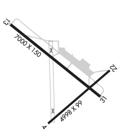
| Lat: N 3349.9 Long: W 08947.9 Elev: 208 Var: -01 Longest Runway: 7000 | ||
| Clr Del: 121.72 GCO AWOS: 118.02 CTAF: 122.8 | ||
| ||||||||||||||||||||||||||||||||||||||||||||
| ||||||||||||||||||||||||||||||||||||||||||||
| ||||||||||||||||||||||||||||||||||||||||||||
| Rwy | Rwy | |||||||
| 4998x99 | 4998' | 4998x99 | 4726' | |||||
| 7000x150 | 7000' | 110.90 - 131° | 7000x150 | 7000' | ||||
| Runway ID | Single Wheel | Double Wheel | Double Tandem Wheel | Dual Double Wheel |
| 04/22 | 60,000 | 200,000 | 300,000 | N/A |
| 13/31 | 60,000 | 200,000 | 300,000 | N/A |
| These numbers are Advisory and are not limits. The Airport Manager should have more accurate Weight Limits | ||||
 Airport Diagram might not be current. | |
| Facility Name: | GRENADA MUNI |
| City Name: | GRENADA |
| County: | GRENADA |
| State abbrev: | MS |
| State Name: | MISSISSIPPI |
| Ownership: | PUBLICLY OWNED |
| Use: | OPEN TO THE PUBLIC |
| Owner's Name: | CITY OF GRENADA |
| Address: | PO BOX 310 |
| GRENADA, MS 38902 | |
| Owner's Phone: | 662-226-8820 |
| Manager's Name: | RANDY ADAMS |
| Address: | PO BOX 310 |
| GRENADA, MS 38902 | |
| Phone: | 662-227-8402 |
| FAA Region: | SOUTHERN |
| FAA Field Office: | JAN |
| Date | Sunrise | Sunset |
|---|---|---|
| 06/08/26 Monday | 5:48 | 20:09 |
| 06/09/26 Tuesday | 5:48 | 20:09 |
| 06/10/26 Wednesday | 5:48 | 20:09 |
| 06/11/26 Thursday | 5:48 | 20:10 |
| 06/12/26 Friday | 5:48 | 20:10 |
| 06/13/26 Saturday | 5:48 | 20:11 |
| 06/14/26 Sunday | 5:48 | 20:11 |
| 06/15/26 Monday | 5:48 | 20:11 |
| 06/16/26 Tuesday | 5:48 | 20:12 |
| 06/17/26 Wednesday | 5:48 | 20:12 |
| 06/18/26 Thursday | 5:48 | 20:12 |
| 06/19/26 Friday | 5:48 | 20:13 |
| 06/20/26 Saturday | 5:49 | 20:13 |
| 06/21/26 Sunday | 5:49 | 20:13 |
| Airport Attendance Schedule | SUN 1300-1700, MON-SAT ON CALL; 662-230-3646. |
| Airport Status | OPERATIONAL (This Status can change at any time - please check NOTAMS) |
| Airport Lighting Schedule | SS-SR |
| Airport Storage Available | Tie Downs |
| Extra Services Available | Crop Dusting |
| Wind Indicator | YES - (lighted) |
| Control Tower | NO |
| CTAF Frequency | 122.800 |
| Unicom Frequency | 122.800 |
| Rotating Beacon Color | WG |
| Segmented Circle | YES |
| Landing Fee | NO |
| Airport Inspected | STATE - performed by STATE AERONAUTICAL PERSONNEL |
| Inspection Date | 01/07/2026 |
| Type of Fuel Available | Grade 100LL, JET A (freeze point -40C) |
| Airframe Repair Service | None |
| Power Plant Repair Service | None |
| Latitude | N3349.9 |
| Longitude | W08947.9 (ESTIMATED) |
| Arpt Elevation | 207ft (SURVEYED) |
| Magnetic Variation | 01E |
| 3 miles N | of GRENADA |
| Traffic Pattern Altitude | |
| Sectional Chart | MEMPHIS |
| Operations (Reported) | Yearly | Avg. Daily |
|---|---|---|
| General Aviation Transient | 0 | 0 |
| General Aviation Local | 0 | 0 |
| Air Taxi | 0 | 0 |
| Commerical | 0 | 0 |
| Commuter | 0 | 0 |
| Military | 0 | 0 |
| Aircraft based on Field | |
|---|---|
| General Aviation Singles | 0 |
| General Aviation Multi | 0 |
| Jet Aircraft | 0 |
| General Aviation Helicopters | 0 |
| Military Aircraft | 0 |
| Gliders | 0 |
| Ultralights | 0 |
| FSS on field | NO |
| FSS tie-in | GREENWOOD |
| FSS Phone | 1-800-WX-BRIEF |
| Who issues Notams | GWO |
| Notam D service at airport | YES |
| ARTCC Name | MEMPHIS |
| Airport Certification | |
| Aircraft Rescue & Firefighting Index | None |
| Airport of Entry | No |
| Custom Landing Rights | No |
| Joint Civil/Military | No |
| Military Landing rights | YES |
| NATIONAL PLAN OF INTEGRATED AIRPORT SYSTEMS (NPIAS) |
| GRANT AGREEMENTS UNDER FAAP/ADAP/AIP |
| SURPLUS PROPERTY AGREEMENT UNDER PUBLIC LAW 289 |
| ASSURANCES PURSUANT TO TITLE VI, CIVIL RIGHTS ACT OF 1964 |
| THIS AIRPORT HAS BEEN SURVEYED BY THE NATIONAL GEODETIC SURVEY. |
| EXTSV AGRICULTURE OPS INVOF ARPT SR-SS MAR-OCT. |
| BIRDS & DEER INVOF ARPT. |
| AEROBATIC ACFT DALGT HRS; 7000 FT & BLW WITHIN 3 NM OF ARPT. |
| FOR CD CTC MEMPHIS ARTCC AT 901-368-8453/8449. |
| ILS DCMSND. |
| RWY 13/3 1 200 FT BY 150 FT ASPH OVRN AVBL. |
| RWY 04/2 2 ASPH CRACKED & HAS DEPRESSIONS. |
Airport Communications & Frequencies:
| |||||||||
| Runway: 04 | Runway: 22 | ||
| Mag heading: | 51° | Mag heading: | 231° |
| Rwy Slope: | .17% Up | Rwy Slope: | -.17% Down |
| Approach: | Approach: | ||
| Pattern: | Left Traffic | Pattern: | Left Traffic |
| Markings: | BASIC | Markings: | BASIC |
| Marking Condition: | POOR; FADED. | Marking Condition: | POOR; FADED. |
| Arresting Dev: | Arresting Dev: | ||
| Lat & Long: | N3349.5 W08948.1 | Lat. & Long.: | N3350.0 W08947.4 |
| Elev: | 192.9 ft. MSL | Elev: | 201.3 ft. MSL |
| TCH: | TCH: | ||
| Visual Glide Path: | Visual Glide Path: | ||
| Displaced Threshold: | No | Displaced Threshold: | 272 feet |
| Touchdown Zone: | YES | Touchdown Zone: | YES |
| Touchdown Elev.: | 196.6 feet | Touchdown Elev.: | 201.4 feet |
| Visual Glide Slope: | Visual Glide Slope: | ||
| RVR Equipment: | RVR Equipment: | ||
| RVV Equipment: | NO | RVV Equipment: | NO |
| Approach Lights: | Approach Lights: | ||
| REIL: | NO | REIL: | NO |
| Centerline Lights: | NO | Centerline Lights: | NO |
| Touchdown lights: | NO | Touchdown lights: | NO |
| Runway Category: | Runway with a Visual Approach | Runway Category: | Runway with a Visual Approach |
| Declared Distances: | Declared Distances: | ||
| Obstructions: | TREES | Obstructions: | ROAD |
| Marked: | NOT Marked/Lighted | Marked: | NOT Marked/Lighted |
| Clearance slope: | 19:1 | Clearance slope: | APCH RATIO 28:1 TO DTHR. |
| Obstruction height: | 59 feet AGL | Obstruction height: | 15 feet AGL |
| Dist. from runway: | 1350 feet | Dist. from runway: | 200 feet |
| Centerline offset: | Centerline offset: | 225 feet right of centerline | |
| Comments: | Comments: | PAVED RD 200 FT FM RWY END 225 FT R & 167 FT L. |
| Runway: 13 | Runway: 31 | ||
| Mag heading: | 131° | Mag heading: | 311° |
| Rwy Slope: | -.14% Down | Rwy Slope: | .14% Up |
| Approach: | ILS/DME | Approach: | |
| Pattern: | Left Traffic | Pattern: | Left Traffic |
| Markings: | PRECISION INSTRUMENT | Markings: | PRECISION INSTRUMENT |
| Marking Condition: | FAIR | Marking Condition: | FAIR |
| Arresting Dev: | Arresting Dev: | ||
| Lat & Long: | N3350.5 W08948.5 | Lat. & Long.: | N3349.7 W08947.5 |
| Elev: | 207.6 ft. MSL | Elev: | 197.8 ft. MSL |
| TCH: | 52 ft. AGL | TCH: | 56 ft. AGL |
| Visual Glide Path: | 3.00 degrees | Visual Glide Path: | 3.00 degrees |
| Displaced Threshold: | No | Displaced Threshold: | No |
| Touchdown Zone: | YES | Touchdown Zone: | YES |
| Touchdown Elev.: | 207.9 feet | Touchdown Elev.: | 202.4 feet |
| Visual Glide Slope: | 4-BOX VASI ON LEFT SIDE OF RUNWAY | Visual Glide Slope: | 4-BOX VASI ON LEFT SIDE OF RUNWAY |
| RVR Equipment: | RVR Equipment: | ||
| RVV Equipment: | NO | RVV Equipment: | NO |
| Approach Lights: | MALSR - 1,400 foot medium intensity approach lighting system with runway alignment indicator lights | Approach Lights: | |
| REIL: | NO | REIL: | NO |
| Centerline Lights: | NO | Centerline Lights: | NO |
| Touchdown lights: | NO | Touchdown lights: | NO |
| Runway Category: | Precision Instrument Runway | Runway Category: | D |
| Declared Distances: | Declared Distances: | ||
| Obstructions: | Obstructions: | TREES | |
| Marked: | Marked: | NOT Marked/Lighted | |
| Clearance slope: | 50:1 | Clearance slope: | 27:1 |
| Obstruction height: | Obstruction height: | 76 feet AGL | |
| Dist. from runway: | Dist. from runway: | 2350 feet | |
| Centerline offset: | Centerline offset: | ||
| Comments: | Comments: |
Thanks for using FltPlan.com
all rights reserved © 1999-2026 by Flight Plan LLC
